Deer Park, Wisconsin

Last updated
Deer Park, Wisconsin
Deer Park Wisconsin Downtown WIS46.jpg
Downtown Deer Park
St. Croix County Wisconsin Incorporated and Unincorporated areas Deer Park Highlighted.svg
Location of Deer Park in St. Croix County, Wisconsin.
Coordinates: 45°11′19″N92°23′20″W / 45.18861°N 92.38889°W / 45.18861; -92.38889
Country Flag of the United States.svg  United States
State Flag of Wisconsin.svg  Wisconsin
County St. Croix
Area
[1]
  Total0.95 sq mi (2.45 km2)
  Land0.91 sq mi (2.36 km2)
  Water0.03 sq mi (0.09 km2)
Elevation
[2]
1,056 ft (322 m)
Population
 (2010) [3]
  Total216
  Estimate 
(2019) [4]
213
  Density233.55/sq mi (90.16/km2)
Time zone UTC-6 (Central (CST))
  Summer (DST) UTC-5 (CDT)
Area code(s) 715 & 534
FIPS code 55-19325 [5]
GNIS feature ID1581620 [2]
Website deerparkwi.com

Deer Park is a village in St. Croix County, Wisconsin, United States. The population was 216 at the 2010 census.

Contents

History

Post office Deer Park Wisconsin Post Office.jpg
Post office

Deer Park was founded in 1876. [6] The village was named after an early nature preserve for deer near the town site. [6] A post office has been in operation in Deer Park since 1876. [7]

Geography

Deer Park is located at 45°11′19″N92°23′20″W / 45.18861°N 92.38889°W / 45.18861; -92.38889 (45.188556, -92.388935). [8] The village is located along Highway 46 and shares its Main street with Highway 46. The only other roads accessing the community are South Street West (also known as Gust Road although this name appears on only one road sign, outside the village limits at the junction of 200 Street and 225 Avenue) and 222 Avenue. Deer Park is located near the headwaters of the Willow River.

According to the United States Census Bureau, the village has a total area of 0.97 square miles (2.51 km2), of which, 0.93 square miles (2.41 km2) of it is land and 0.04 square miles (0.10 km2) is water. [9]

Demographics

Historical population
CensusPop.Note
1880 56
1920 233
1930 187−19.7%
1940 2038.6%
1950 22611.3%
1960 221−2.2%
1970 217−1.8%
1980 2326.9%
1990 2372.2%
2000 227−4.2%
2010 216−4.8%
2019 (est.)213 [4] −1.4%
U.S. Decennial Census [10]

2010 census

As of the census [3] of 2010, there were 216 people, 100 households, and 65 families living in the village. The population density was 232.3 inhabitants per square mile (89.7/km2). There were 113 housing units at an average density of 121.5 per square mile (46.9/km2). The racial makeup of the village was 97.7% White, 0.5% African American, 1.4% Asian, and 0.5% from other races. Hispanic or Latino of any race were 1.4% of the population.

There were 100 households, of which 26.0% had children under the age of 18 living with them, 49.0% were married couples living together, 8.0% had a female householder with no husband present, 8.0% had a male householder with no wife present, and 35.0% were non-families. 30.0% of all households were made up of individuals, and 13% had someone living alone who was 65 years of age or older. The average household size was 2.16 and the average family size was 2.65.

The median age in the village was 43.3 years. 19.4% of residents were under the age of 18; 6% were between the ages of 18 and 24; 26.9% were from 25 to 44; 26.4% were from 45 to 64; and 21.3% were 65 years of age or older. The gender makeup of the village was 50.5% male and 49.5% female.

2000 census

The sign for Deer Park Deer Park Wisconsin Sign.jpg
The sign for Deer Park

As of the census [5] of 2000, there were 227 people, 91 households, and 62 families living in the village. The population density was 253.0 inhabitants per square mile (97.7/km2). There were 94 housing units at an average density of 104.8 per square mile (40.5/km2). The racial makeup of the village was 100.00% White.

There were 91 households, out of which 26.4% had children under the age of 18 living with them, 59.3% were married couples living together, 3.3% had a female householder with no husband present, and 30.8% were non-families. 25.3% of all households were made up of individuals, and 11.0% had someone living alone who was 65 years of age or older. The average household size was 2.49 and the average family size was 3.03.

In the village, the population was spread out, with 25.1% under the age of 18, 5.7% from 18 to 24, 32.6% from 25 to 44, 20.3% from 45 to 64, and 16.3% who were 65 years of age or older. The median age was 36 years. For every 100 females, there were 92.4 males. For every 100 females age 18 and over, there were 109.9 males.

The median income for a household in the village was $51,000, and the median income for a family was $54,583. Males had a median income of $40,208 versus $20,000 for females. The per capita income for the village was $17,367. About 2.6% of families and 4.9% of the population were below the poverty line, including none of those under the age of eighteen and 15.9% of those 65 or over.

Notable people

See also

Related Research Articles

<span class="mw-page-title-main">Deer Park, Illinois</span> Village in Illinois, United States

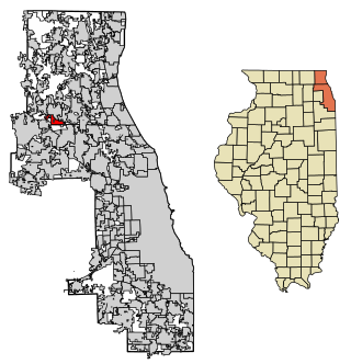
Deer Park is a village in Lake and Cook Counties, Illinois. Per the 2020 census, the population was 3,681. The village is one of the few left in the Chicago area that enjoy a green belt which is bordered by two large natural areas providing outdoor recreation and open space. The village is home to popular shopping and dining destinations: Deer Park Town Center and the Town Center Promenade. The town is also home to the Vehe Farm, an Illinois Centennial Farm.

<span class="mw-page-title-main">Deer Grove, Illinois</span> Village in Illinois, United States

Deer Grove is a village in Whiteside County, Illinois, United States. The population was given as 45 in the 2010 census, down from 48 in 2000.

<span class="mw-page-title-main">Deer Creek, Minnesota</span> City in Minnesota, United States

Deer Creek is a city in Otter Tail County, Minnesota, United States. The population was 330 at the 2020 census.

Deer Township is a township in Roseau County, Minnesota, United States. The population was 92 at the 2000 census.

<span class="mw-page-title-main">Niangua, Missouri</span> City in Missouri, United States

Niangua is a city in Webster County, Missouri, United States. The population was 405 at the 2010 census. Niangua is part of the Springfield, Missouri Metropolitan Statistical Area.

<span class="mw-page-title-main">Deering, North Dakota</span> City in North Dakota, United States

Deering is a city in McHenry County, North Dakota, United States. The population was 94 at the 2020 census. It is part of the Minot Micropolitan Statistical Area. Deering was founded in 1903.

<span class="mw-page-title-main">Jeffersonville, Ohio</span> Village in Ohio, United States

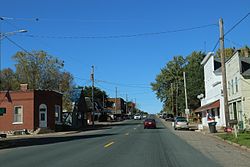
Jeffersonville is a village in Fayette County, Ohio, United States. The population was 1,258 at the 2020 census.

<span class="mw-page-title-main">Mowrystown, Ohio</span> Village in Ohio, United States

Mowrystown is a village in Highland County, Ohio, United States. The population was 385 at the 2020 census.

<span class="mw-page-title-main">Williamsport, Ohio</span> Village in Ohio, United States

Williamsport is a village in Pickaway County, Ohio, United States. The population was 1,023 at the 2010 census.

<span class="mw-page-title-main">Oliver, Wisconsin</span> Village in Wisconsin, United States

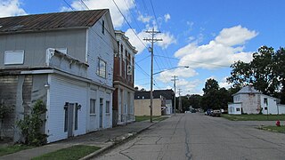
Oliver is a village in Douglas County, Wisconsin, United States. The population was 423 at the 2020 census.

<span class="mw-page-title-main">Deer Creek, Outagamie County, Wisconsin</span> Town in Wisconsin, United States

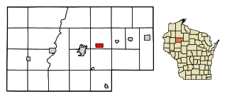
Deer Creek is a town in Outagamie County, Wisconsin, United States. The population was 682 at the 2000 census. Area of the village is 35.5 sq mi (92.0 km2)

<span class="mw-page-title-main">Bay City, Wisconsin</span> Village in Wisconsin, United States

Bay City is a village on the Mississippi River in Pierce County, Wisconsin, United States. The population was 500 at the 2010 census.

<span class="mw-page-title-main">Centuria, Wisconsin</span> Village in Wisconsin, United States

Centuria is a village in Polk County, Wisconsin, United States. The population was 948 at the 2010 census.

<span class="mw-page-title-main">Tony, Wisconsin</span> Village in Wisconsin, United States

Tony is a village in Rusk County, Wisconsin, United States. The population was 113 at the 2010 census.

<span class="mw-page-title-main">Roberts, Wisconsin</span> Village in Wisconsin, United States

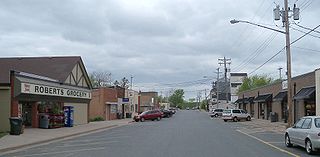
Roberts is a village in St. Croix County, Wisconsin, United States. The population was 1,651 at the 2010 census. The village is surrounded by the town of Warren.

Andes is a hamlet and census-designated place (CDP) in Delaware County, New York, United States. The population was 252 at the 2010 census. It was formerly a village.

<span class="mw-page-title-main">Mount Hope, Wisconsin</span> Village in Wisconsin, United States

Mount Hope is a village in Grant County, Wisconsin, United States. The population was 225 at the 2010 census. The village is located within the Town of Mount Hope.

<span class="mw-page-title-main">Balsam Lake, Wisconsin</span> Village in Wisconsin, United States

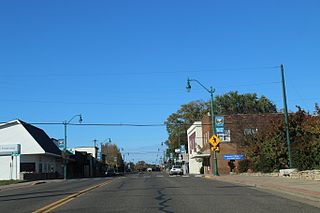
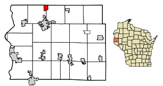
Balsam Lake is a village in, and the county seat of Polk County, Wisconsin, United States. The population was 1,009 at the 2010 census. The village is located within the Town of Balsam Lake.

<span class="mw-page-title-main">Clayton (village), Wisconsin</span> Village in Wisconsin, United States

Clayton is a village in Polk County, Wisconsin, United States. The population was 571 at the 2010 census. The village is located within the Town of Clayton.

<span class="mw-page-title-main">Star Prairie, Wisconsin</span> Village in Wisconsin, United States

Star Prairie is a village in St. Croix County in the U.S. state of Wisconsin. The population was 561 at the 2010 census. The village is located along the Apple River on the boundary between the Town of Star Prairie and the Town of Stanton.

References

  1. "2019 U.S. Gazetteer Files". United States Census Bureau. Retrieved August 7, 2020.
  2. 1 2 "US Board on Geographic Names". United States Geological Survey. 2007-10-25. Retrieved 2008-01-31.
  3. 1 2 "U.S. Census website". United States Census Bureau . Retrieved 2012-11-18.
  4. 1 2 "Population and Housing Unit Estimates". United States Census Bureau. May 24, 2020. Retrieved May 27, 2020.
  5. 1 2 "U.S. Census website". United States Census Bureau . Retrieved 2008-01-31.
  6. 1 2 Chicago and North Western Railway Company (1908). A History of the Origin of the Place Names Connected with the Chicago & North Western and Chicago, St. Paul, Minneapolis & Omaha Railways. p. 172.
  7. "Saint Croix County". Jim Forte Postal History. Retrieved 3 April 2015.
  8. "US Gazetteer files: 2010, 2000, and 1990". United States Census Bureau. 2011-02-12. Retrieved 2011-04-23.
  9. "US Gazetteer files 2010". United States Census Bureau. Archived from the original on 2012-01-25. Retrieved 2012-11-18.
  10. "Census of Population and Housing". Census.gov. Retrieved June 4, 2015.