Kinnickinnic, Wisconsin

Last updated

Kinnickinnic, Wisconsin
WIMap-doton-Kinnickinnic.png
Location of Kinnickinnic, Wisconsin
Coordinates: 44°54′33″N92°33′4″W / 44.90917°N 92.55111°W / 44.90917; -92.55111
Country Flag of the United States.svg  United States
State Flag of Wisconsin.svg  Wisconsin
County St. Croix
Area
  Total35.4 sq mi (91.8 km2)
  Land35.4 sq mi (91.8 km2)
  Water0.0 sq mi (0.0 km2)
Elevation
[1]
938 ft (286 m)
Population
 (2000)
  Total1,400
  Density39.5/sq mi (15.3/km2)
Time zone UTC-6 (Central (CST))
  Summer (DST) UTC-5 (CDT)
Area code(s) 715 & 534
FIPS code 55-39825 [2]
GNIS feature ID1583486 [1]

Kinnickinnic is a town in St. Croix County, Wisconsin, United States. The population was 1,400 at the 2000 census.

Contents

History

The word kinnickinnic is Chippewa and Cree dialects of the Algonquian language in origin. It literally means "what is mixed," when referring to the mixing of indigenous plants and tobaccos. [3]

Geography

According to the United States Census Bureau, the town has a total area of 35.4 square miles (91.8 km2), all of it land.

Demographics

Historical population
CensusPop.Note
2010 1,722
2012 (est.)1,7401.0%

As of the census [2] of 2000, there were 1,400 people, 483 households, and 396 families residing in the town. The population density was 39.5 inhabitants per square mile (15.3/km2). There were 492 housing units at an average density of 13.9 per square mile (5.4/km2). The racial makeup of the town was 98.43% White, 0.64% African American, 0.07% Asian, 0.14% from other races, and 0.71% from two or more races. Hispanic or Latino of any race were 0.14% of the population.

There were 483 households, out of which 41.0% had children under the age of 18 living with them, 76.4% were married couples living together, 3.5% had a female householder with no husband present, and 18.0% were non-families. 14.7% of all households were made up of individuals, and 4.1% had someone living alone who was 65 years of age or older. The average household size was 2.90 and the average family size was 3.23.

In the town, the population was spread out, with 29.2% under the age of 18, 7.2% from 18 to 24, 28.5% from 25 to 44, 27.7% from 45 to 64, and 7.4% who were 65 years of age or older. The median age was 37 years. For every 100 females, there were 98.3 males. For every 100 females age 18 and over, there were 99.8 males.

The median income for a household in the town was $62,727, and the median income for a family was $71,354. Males had a median income of $47,375 versus $34,583 for females. The per capita income for the town was $23,665. About 2.2% of families and 3.6% of the population were below the poverty line, including 2.9% of those under age 18 and 11.7% of those age 65 or over.

Notable people

Buildings and structures

Related Research Articles

<span class="mw-page-title-main">Ashley, Indiana</span> Town in Indiana, United States

Ashley is a town in Indiana located on the border of Smithfield Township, DeKalb County and Steuben Township, Steuben County. The population was 983 at the 2010 census.

<span class="mw-page-title-main">Mecca, Indiana</span> Town in Indiana, United States

Mecca is a town in Wabash Township, Parke County, in the U.S. state of Indiana. The population was 335 at the 2010 census.

<span class="mw-page-title-main">Spurgeon, Indiana</span> Town in Indiana, United States

Spurgeon is a town in Monroe Township, Pike County, in the U.S. state of Indiana. The population was 207 at the 2010 census. It is part of the Jasper Micropolitan Statistical Area.

<span class="mw-page-title-main">Caswell, Maine</span> Town in the state of Maine, United States

Caswell is a town in Aroostook County, Maine, United States. The population was 293 at the 2020 census.

<span class="mw-page-title-main">Washburn, Maine</span> Town in the state of Maine, United States

Washburn is a town in Aroostook County, Maine, United States. It was incorporated on February 25, 1861, and named after Israel Washburn, the governor of Maine at the time. The population was 1,527 at the 2020 census. Benjamin C. Wilder House, which was built in 1852, is located on Main Street in Washburn and predates the town's incorporation by nine years.

<span class="mw-page-title-main">Prairie Rose, North Dakota</span> City in North Dakota, United States

Prairie Rose is a city in Cass County, North Dakota, United States. The population was 56 at the 2020 census. The city is an enclave suburb of Fargo. Prairie Rose was founded in 1975 and it was incorporated in 1978. There are 21 homes in the city.

<span class="mw-page-title-main">Lore City, Ohio</span> Village in Ohio, United States

Lore City is a village in Guernsey County, Ohio, United States. The population was 282 at the 2020 census.

<span class="mw-page-title-main">South Pymatuning Township, Pennsylvania</span> Township in Pennsylvania, United States

South Pymatuning Township is a township in Mercer County, Pennsylvania, United States. The population was 2,650 at the 2020 census, a decrease from 2,695 in 2010.

<span class="mw-page-title-main">Grandview, Wisconsin</span> Town in Wisconsin, United States

Grandview is a town in Bayfield County, Wisconsin, United States. The population was 468 at the 2010 census. The unincorporated community of Grand View is located in the town of Grandview.

<span class="mw-page-title-main">Rockland, Brown County, Wisconsin</span> Town in Wisconsin, United States

Rockland is a town in Brown County in the U.S. state of Wisconsin. The population was 1,734 at the 2010 census.

<span class="mw-page-title-main">Meenon, Wisconsin</span> Town in Wisconsin, United States

Meenon is a town in Burnett County in the U.S. state of Wisconsin. The population was 1,163 at the 2010 census. It is the home of the Burnett County Government Center.

<span class="mw-page-title-main">Westford, Dodge County, Wisconsin</span> Town in Wisconsin, United States

Westford is a town in Dodge County, Wisconsin, United States. The population was 1,400 at the 2000 census. The unincorporated community of South Randolph is located in the town. The unincorporated community of Lost Lake is also located partially in the town.

<span class="mw-page-title-main">Sheridan, Wisconsin</span> Town in Wisconsin, United States

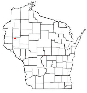
Sheridan is a town in Dunn County, Wisconsin, United States. The population was 483 at the 2000 census.

<span class="mw-page-title-main">Sherman, Iron County, Wisconsin</span> Town in Wisconsin, United States

Sherman is a town in Iron County, Wisconsin, United States. The population was 336 at the 2000 census. The unincorporated communities of Powell and Springstead are located in the town. The Lac du Flambeau Band of Lake Superior Chippewa is located partially in the town.

<span class="mw-page-title-main">Greenfield, Wisconsin</span> City in Wisconsin, United States

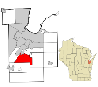
Greenfield is a city in Milwaukee County, Wisconsin, United States. The population was 37,803 as of the 2020 census. Greenfield is one of many bedroom communities in the Milwaukee metropolitan area.

<span class="mw-page-title-main">Grant, Monroe County, Wisconsin</span> Town in Wisconsin, United States

Grant is a town in Monroe County, Wisconsin, United States. The population was 483 at the 2000 census.

<span class="mw-page-title-main">Randolph, Wisconsin</span> Village in Wisconsin, United States

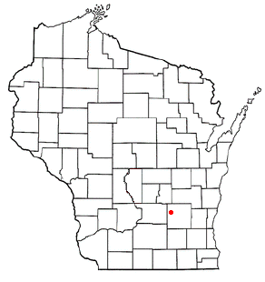
Randolph is a village in Columbia and Dodge Counties in the U.S. state of Wisconsin. The population was 1,811 at the 2010 census. Of this, 1,339 were in Dodge County, and 472 were in Columbia County. The village is located at the southeast corner of the Town of Randolph in Columbia County, although only a tiny portion of the village lies within the town. Most of the village lies within the Town of Westford in Dodge County. Small portions also lie within the Town of Fox Lake to the north and the Town of Courtland in Columbia County.

<span class="mw-page-title-main">River Falls, Wisconsin</span> City in Wisconsin, United States

River Falls is a city in Pierce and St. Croix counties in the U.S. state of Wisconsin. It is located mostly within the town of River Falls, and adjacent to the town of Kinnickinnic in St. Croix County. River Falls is the most populous city in Pierce County. The population was 16,182 at the 2020 census, with 12,546 residing in Pierce County and 3,636 in St. Croix County. It is part of the Minneapolis-St. Paul metropolitan area and located approximately 30 miles (48 km) east of the center of that region.

<span class="mw-page-title-main">Orleans, Indiana</span> Town in Indiana, United States

Orleans is a town in Orleans Township, Orange County, in the U.S. state of Indiana. The population was 2,142 at the 2010 census.

<span class="mw-page-title-main">Limestone, Maine</span> Town in the United States

Limestone is a town in Aroostook County, Maine, United States. The population was 1,526 at the 2020 census.

References

  1. 1 2 "US Board on Geographic Names". United States Geological Survey. October 25, 2007. Retrieved January 31, 2008.
  2. 1 2 "U.S. Census website". United States Census Bureau . Retrieved January 31, 2008.
  3. Town of Kinnickinnic
  4. Minnesota State Law Library-Charles Loring Archived January 5, 2014, at the Wayback Machine
  5. George A. Williams