Forest, St. Croix County, Wisconsin

Last updated

Forest, Wisconsin
WIMap-doton-Forest c.png
Location of Forest, St. Croix County, Wisconsin
Coordinates: 45°9′30″N92°13′46″W / 45.15833°N 92.22944°W / 45.15833; -92.22944
Country Flag of the United States.svg  United States
State Flag of Wisconsin.svg  Wisconsin
County St. Croix
Area
  Total37.2 sq mi (96.4 km2)
  Land37.2 sq mi (96.2 km2)
  Water0.1 sq mi (0.1 km2)
Elevation
[1]
1,214 ft (370 m)
Population
 (2000)
  Total590
  Density15.9/sq mi (6.1/km2)
Time zone UTC-6 (Central (CST))
  Summer (DST) UTC-5 (CDT)
Area code(s) 715 & 534
FIPS code 55-26525 [2]
GNIS feature ID1583215 [1]

Forest is a town in St. Croix County, Wisconsin, United States. The population was 590 at the 2000 census. The unincorporated community of Forest is located in the town.

Contents

Geography

According to the United States Census Bureau, the town has a total area of 37.2 square miles (96.4 km2), of which, 37.2 square miles (96.2 km2) of it is land and 0.1 square miles (0.1 km2) of it (0.13%) is water.

Demographics

Historical population
CensusPop.Note
2010 629
2012 (est.)628−0.2%

As of the census [2] of 2000, there were 590 people, 203 households, and 165 families residing in the town. The population density was 15.9 inhabitants per square mile (6.1/km2). There were 218 housing units at an average density of 5.9 per square mile (2.3/km2). The racial makeup of the town was 99.15% White, 0.17% Native American, 0.34% from other races, and 0.34% from two or more races. Hispanic or Latino of any race were 0.85% of the population.

There were 203 households, out of which 39.9% had children under the age of 18 living with them, 72.4% were married couples living together, 3.9% had a female householder with no husband present, and 18.7% were non-families. 14.3% of all households were made up of individuals, and 4.9% had someone living alone who was 65 years of age or older. The average household size was 2.91 and the average family size was 3.19.

In the town, the population was spread out, with 28.6% under the age of 18, 7.1% from 18 to 24, 28.6% from 25 to 44, 24.2% from 45 to 64, and 11.4% who were 65 years of age or older. The median age was 37 years. For every 100 females, there were 116.9 males. For every 100 females age 18 and over, there were 109.5 males.

The median income for a household in the town was $50,833, and the median income for a family was $60,000. Males had a median income of $36,023 versus $22,014 for females. The per capita income for the town was $21,427. About 4.3% of families and 8.3% of the population were below the poverty line, including 9.8% of those under age 18 and 5.1% of those age 65 or over.

45°08′12″N92°15′35″W / 45.13667°N 92.25972°W / 45.13667; -92.25972

Related Research Articles

<span class="mw-page-title-main">Frenchville, Maine</span> Town in the state of Maine, United States

Frenchville is a town in Aroostook County, Maine, United States. The population was 1,052 at the 2020 census.

<span class="mw-page-title-main">Hammond, Maine</span> Town in the state of Maine, United States

Hammond is a town in Aroostook County, Maine, United States. The population was 91 at the 2020 census.

<span class="mw-page-title-main">Orient, Maine</span> Town in the state of Maine, United States

Orient is a town in Aroostook County, Maine, United States. The population was 156 at the 2020 census.

<span class="mw-page-title-main">Westmanland, Maine</span> Town in the state of Maine, United States

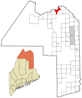
Westmanland is a town in Aroostook County, Maine, United States. The population was 79 at the 2020 census.

Orland is a town in Hancock County, Maine, United States. The population was 2,221 at the 2020 census.

<span class="mw-page-title-main">Clifton, Maine</span> Town in the state of Maine, United States

Clifton is a town in Penobscot County, Maine, United States. The population was 840 at the 2020 census. It is part of the Bangor Metropolitan Statistical Area.

Hudson is a town in Penobscot County, Maine, United States. The population was 1,416 at the 2020 census.

<span class="mw-page-title-main">Dennysville, Maine</span> Town in the state of Maine, United States

Dennysville is a town in Washington County, Maine, United States. The population was 300 at the 2020 census.

<span class="mw-page-title-main">Hammond, Minnesota</span> City in Minnesota, United States

Hammond is a city in Wabasha County, Minnesota, United States. The population was 132 at the 2010 census.

<span class="mw-page-title-main">Pilot Rock, Oregon</span> City in Oregon, United States

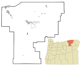
Pilot Rock is a city in Umatilla County, Oregon, United States. The population was 1,502 at the 2010 census. It is part of the Pendleton–Hermiston Micropolitan Statistical Area. The main industries are timber and agriculture. Pilot Rock is home to the Boise Cascade /Kinzua Lumber lumber and pole mill as well as Pilot Rock High School. The name of Pilot Rock refers to a large basalt rock formation which is visible from the old Oregon Trail and was used in navigating wagon trains through the area.

<span class="mw-page-title-main">Union, Pierce County, Wisconsin</span> Town in Wisconsin, United States

Union is a town in Pierce County, Wisconsin, United States. The population was 618 at the 2000 census. The unincorporated community of Ono is located partially in the town.

<span class="mw-page-title-main">Willow, Wisconsin</span> Town in Wisconsin, United States

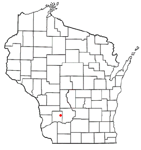
Willow is a town in Richland County, Wisconsin, United States. The population was 493 at the 2000 census. The unincorporated community of Loyd is located in the town.

<span class="mw-page-title-main">Erin Prairie, Wisconsin</span> Town in Wisconsin, United States

Erin Prairie is a town in St. Croix County, Wisconsin, United States. The population was 658 at the 2000 census. The unincorporated communities of Erin Corner and Jewitt are located in the town.

<span class="mw-page-title-main">Spring Prairie, Wisconsin</span> Town in Wisconsin, United States

Spring Prairie is a town in Walworth County, Wisconsin, United States. The population was 2,123 at the 2020 census. The unincorporated communities of Spring Prairie and Voree are located in the town. The unincorporated communities of Honey Creek and Honey Lake are also located partially in the town.

<span class="mw-page-title-main">Long Lake, Washburn County, Wisconsin</span> Town in Wisconsin, United States

Long Lake is a town in Washburn County, Wisconsin, United States. The population was 737 at the 2000 census. The unincorporated community of Nobleton is located in the town.

Northeast Aitkin is an unorganized territory in Aitkin County, Minnesota, United States. The population was 11 at the 2010 census.

<span class="mw-page-title-main">Ware (CDP), Massachusetts</span> Census-designated place in Massachusetts, United States

Ware is a census-designated place (CDP) comprising the main village in the town of Ware in Hampshire County, Massachusetts, United States. The population of the CDP was 6,170 at the 2010 census, out of a total town population of 9,872. It is part of the Springfield, Massachusetts Metropolitan Statistical Area.

Rosendale is a town in Fond du Lac County, Wisconsin, United States. The population was 783 at the 2000 census. The village of Rosendale is located partially within the town. The unincorporated communities of Rosendale Center and West Rosendale are also located in the town.

Clear Lake is a town in Polk County, Wisconsin, United States. The population was 800 at the 2000 census. The Village of Clear Lake is located within the town.

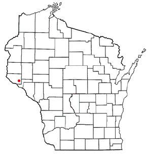
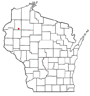
Hammond is a town in St. Croix County, Wisconsin, United States. The population was 947 at the 2000 census. The Village of Hammond is located within the town.

References

  1. 1 2 "US Board on Geographic Names". United States Geological Survey. October 25, 2007. Retrieved January 31, 2008.
  2. 1 2 "U.S. Census website". United States Census Bureau . Retrieved January 31, 2008.