Star Prairie, Wisconsin

Last updated
Star Prairie, Wisconsin
St. Croix County Wisconsin Incorporated and Unincorporated areas Star Prairie Highlighted.svg
Location of Star Prairie
in St. Croix County, Wisconsin
Coordinates: 45°11′53″N92°31′55″W / 45.19806°N 92.53194°W / 45.19806; -92.53194 Coordinates: 45°11′53″N92°31′55″W / 45.19806°N 92.53194°W / 45.19806; -92.53194
Country Flag of the United States.svg  United States
State Flag of Wisconsin.svg  Wisconsin
County St. Croix
Area
[1]
  Total2.14 sq mi (5.55 km2)
  Land2.14 sq mi (5.55 km2)
  Water0.00 sq mi (0.00 km2)
Elevation
[2]
879 ft (268 m)
Population
 (2010) [3]
  Total561
  Estimate 
(2019) [4]
556
  Density259.45/sq mi (100.16/km2)
Time zone UTC-6 (Central (CST))
  Summer (DST) UTC-5 (CDT)
Area code(s) 715 & 534
FIPS code 55-76850 [5]
GNIS feature ID1581735 [2]
Website villageofstarprairie.com

Star Prairie is a village in St. Croix County in the U.S. state of Wisconsin. The population was 561 at the 2010 census. The village is located along the Apple River on the boundary between the Town of Star Prairie and the Town of Stanton.

Contents

Geography

Star Prairie is located at 45°11′53″N92°31′55″W / 45.19806°N 92.53194°W / 45.19806; -92.53194 (45.198274, -92.531987). [6]

According to the United States Census Bureau, the village has a total area of 2.16 square miles (5.59 km2), all of it land. [7] The Apple River flows through the center of town, where it is joined by a small stream called Saratoga Spring.

Wisconsin Highway 65, County Road H, and County Road M are main routes in the community. County Road C is nearby.

Demographics

Historical population
CensusPop.
1910 253
1920 2654.7%
1930 250−5.7%
1940 2500.0%
1950 28815.2%
1960 33114.9%
1970 3629.4%
1980 42016.0%
1990 50720.7%
2000 57413.2%
2010 561−2.3%
2019 (est.)556 [4] −0.9%
U.S. Decennial Census [8]

2010 census

At the 2010 census there were 561 people, 230 households, and 155 families in the village. The population density was 259.7 inhabitants per square mile (100.3/km2). There were 248 housing units at an average density of 114.8 per square mile (44.3/km2). The racial makup of the village was 96.6% White, 1.4% Native American, 0.9% Asian, and 1.1% from two or more races. Hispanic or Latino of any race were 1.6%. [3]

Of the 230 households 33.5% had children under the age of 18 living with them, 47.4% were married couples living together, 12.2% had a female householder with no husband present, 7.8% had a male householder with no wife present, and 32.6% were non-families. 27.8% of households were one person and 7.8% were one person aged 65 or older. The average household size was 2.44 and the average family size was 2.95.

The median age in the village was 36.1 years. 26.7% of residents were under the age of 18; 6.9% were between the ages of 18 and 24; 27.5% were from 25 to 44; 26.4% were from 45 to 64; and 12.5% were 65 or older. The gender makeup of the village was 50.8% male and 49.2% female.

2000 census

At the 2000 census there were 574 people, 212 households, and 145 families in the village. The population density was 273.3 inhabitants per square mile (105.5/km2). There were 215 housing units at an average density of 102.4 per square mile (39.5/km2). The racial makup of the village was 97.74% White, 0.17% Black or African American and 2.09% Asian. 0.17%. [5] were Hispanic or Latino of any race.

Of the 212 households 38.2% had children under the age of 18 living with them, 56.1% were married couples living together, 9.0% had a female householder with no husband present, and 31.6% were non-families. 23.6% of households were one person and 9.0% were one person aged 65 or older. The average household size was 2.71 and the average family size was 3.28.

The age distribution was 28.0% under the age of 18, 11.3% from 18 to 24, 35.0% from 25 to 44, 17.1% from 45 to 64, and 8.5% 65 or older. The median age was 32 years. For every 100 females, there were 98.6 males. For every 100 females age 18 and over, there were 102.5 males.

The median household income was $48,750 and the median family income was $49,000. Males had a median income of $36,583 versus $22,679 for females. The per capita income for the village was $19,414. About 2.9% of families and 4.0% of the population were below the poverty line, including 3.9% of those under age 18 and 4.9% of those age 65 or over.

Related Research Articles

<span class="mw-page-title-main">Whitmore Village, Hawaii</span> Census-designated place in Hawaii, United States

Whitmore Village is a census-designated place (CDP) in Honolulu County, Hawaiʻi, United States. The population was 4,887 at the 2020 census.

<span class="mw-page-title-main">Weippe, Idaho</span> City in Idaho, United States

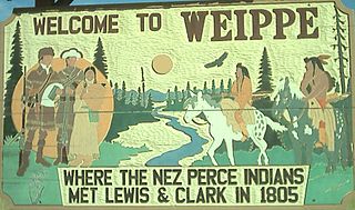
Weippe is a city in Clearwater County, Idaho, United States. The population was 441 at the 2010 census, up from 411 in 2000. In September 1805, the starving Lewis and Clark Expedition first met the Nez Perce on the Weippe Prairie, south of the city.

<span class="mw-page-title-main">Shellsburg, Iowa</span> City in Iowa, United States

Shellsburg is a city in Benton County, Iowa, United States. The population was 961 at the time of the 2020 census. It is part of the Cedar Rapids Metropolitan Statistical Area.

<span class="mw-page-title-main">Rinard, Iowa</span> City in Iowa, United States

Rinard is a city in Calhoun County, Iowa, United States. The population was 38 at the time of the 2020 census.

<span class="mw-page-title-main">Grand River, Iowa</span> City in Iowa, United States

Grand River is a city in northwest Decatur County, Iowa, United States. The population was 196 at the time of the 2020 census.

<span class="mw-page-title-main">Wyoming, Iowa</span> City in Iowa, United States

Wyoming is a city in Jones County, Iowa, United States. The population was 523 at the time of the 2020 census. It is part of the Cedar Rapids Metropolitan Statistical Area.

<span class="mw-page-title-main">West Chester, Iowa</span> City in Iowa, United States

West Chester is a city in Washington County, Iowa, United States. It is part of the Iowa City, Iowa Metropolitan Statistical Area. The population was 144 at the time of the 2020 census.

<span class="mw-page-title-main">Callender, Iowa</span> City in Iowa, United States

Callender is a city in Webster County, Iowa, United States. The population was 368 at the time of the 2020 census.

<span class="mw-page-title-main">Powhattan, Kansas</span> City in Brown County, Kansas

Powhattan is a city in Brown County, Kansas, United States. As of the 2020 census, the population of the city was 69.

<span class="mw-page-title-main">Unity Village, Missouri</span> Village in Missouri, United States

Unity Village is a village in Jackson County, Missouri, United States, bordering Kansas City and Lee's Summit. Its population was 99 at the 2010 census. It is the world headquarters of Unity Church, which has over 2 million followers. The Unity Tower was designed by the Kansas City firm Boillot & Lauck and built in 1929 to store water. Unity Village is part of the Kansas City metropolitan area.

<span class="mw-page-title-main">Tarrants, Missouri</span> Inactive Village in Missouri, United States

Tarrants is an inactive village in central Pike County, Missouri, United States. The population was 22 at the 2010 census.

<span class="mw-page-title-main">Snyder, Nebraska</span> Village in Nebraska, United States

Snyder is a village in Dodge County, Nebraska, United States. The population was 300 at the 2010 census.

<span class="mw-page-title-main">Milligan, Nebraska</span> Village in Nebraska, United States

Milligan is a village in Fillmore County, Nebraska, United States. The population was 241 at the 2020 census.

<span class="mw-page-title-main">Riverton, Nebraska</span> Village in Nebraska, United States

Riverton is a village in Franklin County, Nebraska, United States. The population was 89 at the 2010 census.

<span class="mw-page-title-main">Cleveland, North Dakota</span> City in North Dakota, United States

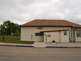
Cleveland is a city in Stutsman County, North Dakota, United States. The population was 57 at the 2020 census.

<span class="mw-page-title-main">Dillonvale, Jefferson County, Ohio</span> Village in Ohio, United States

Dillonvale is a village in southern Jefferson County, Ohio, United States. The population was 589 at the 2020 census. It is part of the Weirton–Steubenville metropolitan area.

<span class="mw-page-title-main">Sherwood, Wisconsin</span> Village in Wisconsin, United States

Sherwood is a village in Calumet County, Wisconsin, United States. The population was 2,713 at the 2010 census. The former historical unincorporated community of High Cliff is located within present-day Sherwood.

<span class="mw-page-title-main">Readstown, Wisconsin</span> Village in Wisconsin, United States

Readstown is a village in Vernon County, Wisconsin, United States. The population was 415 at the 2010 census.

<span class="mw-page-title-main">Prairie Farm, Wisconsin</span> Village in Wisconsin, United States

Prairie Farm is a village in Barron County in the U.S. state of Wisconsin. The population was 473 at the 2010 census. The village is located within the Town of Prairie Farm, on eastern shore of the Prairie Farm Flowage, a reservoir on the Hay River.

<span class="mw-page-title-main">Winter, Wisconsin</span> Village in Wisconsin, United States

Winter is a village in Sawyer County, Wisconsin, United States. The population was 233 at the 2010 census. The village is within the Town of Winter.

References

  1. "2019 U.S. Gazetteer Files". United States Census Bureau. Retrieved August 7, 2020.
  2. 1 2 "US Board on Geographic Names". United States Geological Survey. 2007-10-25. Retrieved 2008-01-31.
  3. 1 2 "U.S. Census website". United States Census Bureau . Retrieved 2012-11-18.
  4. 1 2 "Population and Housing Unit Estimates". United States Census Bureau. May 24, 2020. Retrieved May 27, 2020.
  5. 1 2 "U.S. Census website". United States Census Bureau . Retrieved 2008-01-31.
  6. "US Gazetteer files: 2010, 2000, and 1990". United States Census Bureau. 2011-02-12. Retrieved 2011-04-23.
  7. "US Gazetteer files 2010". United States Census Bureau. Archived from the original on 2012-01-25. Retrieved 2012-11-18.
  8. "Census of Population and Housing". Census.gov. Retrieved June 4, 2015.