St. Joseph, Wisconsin

Last updated

St. Joseph, Wisconsin
WIMap-doton-St Joseph.png
Location of St. Joseph, Wisconsin
Coordinates: 45°2′58″N92°42′39″W / 45.04944°N 92.71083°W / 45.04944; -92.71083
Country Flag of the United States.svg  United States
State Flag of Wisconsin.svg  Wisconsin
County St. Croix
Area
[1]
  Total32.0 sq mi (83.0 km2)
  Land29.7 sq mi (76.9 km2)
  Water2.35 sq mi (6.1 km2)
Elevation
[2]
833 ft (254 m)
Population
 (2010) [3]
  Total3,842
  Density129.4/sq mi (50.0/km2)
Time zone UTC-6 (Central (CST))
  Summer (DST) UTC-5 (CDT)
Area code(s) 715 & 534
FIPS code 55-70825 [4]
GNIS feature ID1584089 [2]

St. Joseph is a town in St. Croix County, Wisconsin, United States. The population was 3,842 at the 2010 census. The unincorporated communities of Burkhardt, and Houlton are located in the town.

Contents

Geography

According to the United States Census Bureau, the town has a total area of 32.0 square miles (82.88 km2), of which 29.7 square miles (76.92 km2) is land. [1]

Demographics

Historical population
CensusPop.Note
2010 3,842
2012 (est.)3,8811.0%

2010 census

As of the census [3] of 2010, there were 3842 people, 1388 households, and 1136 families living in the town. The population density was 129.4 inhabitants per square mile (50.0/km2). There were 1511 housing units at an average density of 50.9 per square mile (19.7/km2). The racial makeup of the town was 96.1% White, 2.6% from other races, and 1.3% from two or more races. Hispanic or Latino of any race were 2.4% of the population.

There were 1388 households, out of which 35.4% had children under the age of 18 living with them, 72.4% were married couples living together, 5.4% had a female householder with no husband present, 4.0% had a male householder with no wife present, and 18.2% were non-families. 13.5% of all households were made up of individuals, and 4.2% had someone living alone who was 65 years of age or older. The average household size was 2.74 and the average family size was 3.00.

The median age in the town was 42.9 years. 24.9% of residents were under the age of 18; 5.5% were between the ages of 18 and 24; 23.5% were from 25 to 44; 36.2% were from 45 to 64; and 9.9% were 65 years of age or older. The gender makeup of the town was 51.6% male and 48.4% female.

The median household income in the town was $84,769; the per capita income was $40,466. About 5.7% of families and 8.9% of the population were below the poverty line, including 12.8% of those below the age of eighteen, but no persons over the age of sixty-five.

2000 census

As of the census [4] of 2000, there were 3,436 people, 1,193 households, and 979 families living in the town. The population density was 106.9 inhabitants per square mile (41.3/km2). There were 1,259 housing units at an average density of 39.2 per square mile (15.1/km2). The racial makeup of the town was 97.93% White, 0.26% African American, 0.26% Native American, 0.61% Asian, 0.15% Pacific Islander, 0.23% from other races, and 0.55% from two or more races. Hispanic or Latino of any race were 0.76% of the population.

There were 1,193 households, out of which 41.5% had children under the age of 18 living with them, 74.0% were married couples living together, 4.7% had a female householder with no husband present, and 17.9% were non-families. 13.4% of all households were made up of individuals, and 2.6% had someone living alone who was 65 years of age or older. The average household size was 2.86 and the average family size was 3.15.

In the town, the population was spread out, with 27.8% under the age of 18, 4.9% from 18 to 24, 33.7% from 25 to 44, 26.0% from 45 to 64, and 6.1% who were 65 years of age or older. The median age was 37 years. For every 100 females, there were 111.4 males. For every 100 females age 18 and over, there were 107.6 males.

The median income for a household in the town was $81,277, and the median income for a family was $80,606. Males had a median income of $52,813 versus $32,283 for females. The per capita income for the town was $30,988. About 0.3% of families and 1.4% of the population were below the poverty line, including none of those under the age of eighteen or sixty-five or over.

Related Research Articles

<span class="mw-page-title-main">Eclectic, Alabama</span> Village in Alabama, United States

Eclectic is a town in Elmore County, Alabama, United States. It incorporated in 1907. At the 2020 census, the population was 1,193. It is part of the Montgomery Metropolitan Statistical Area.

<span class="mw-page-title-main">Chatom, Alabama</span> City in and county seat of Washington County, Alabama

Chatom is a town in Washington County, Alabama, United States. It incorporated in 1949. Chatom is the county seat of Washington County, holding the distinction since 1907. The town's population was 1,288 At the 2010 census, up from 1,193 in 2000.

<span class="mw-page-title-main">Lewiston, California</span> Census-designated place in California, United States

Lewiston is a census-designated place (CDP) in Trinity County, California, United States. Its population is 1,222 as of the 2020 census, up from 1,193 from the 2010 census.

<span class="mw-page-title-main">Smelterville, Idaho</span> City in Idaho, United States

Smelterville is a city in Shoshone County, Idaho, United States. The population was 627 at the 2010 census.

<span class="mw-page-title-main">Spencer, Indiana</span> Town in Indiana, United States

Spencer is a town in Washington Township, Owen County, in the U.S. state of Indiana. The population was 2,217 at the 2010 census. It is the county seat of Owen County.

<span class="mw-page-title-main">Bancroft, Kentucky</span> City in Kentucky, United States

Bancroft is a home rule-class city in Jefferson County, Kentucky, United States. It was formally incorporated by the state assembly in 1970. The population was 503 as of the 2020 census, up from 494 at the 2010 census.

<span class="mw-page-title-main">Berwick, Louisiana</span> Town in Louisiana, United States

Berwick is a town in St. Mary Parish, Louisiana, United States. The population was 4,946 at the 2010 census. It is part of the Morgan City Micropolitan Statistical Area.

<span class="mw-page-title-main">Eagle Lake, Maine</span> Town in the state of Maine, United States

Eagle Lake is a town in Aroostook County, Maine, United States. The population was 772 at the 2020 census. The town was named by a body of troops heading from Bangor to the Aroostook War for the many eagles that they saw around the lake. A total of 49.0% of the population speaks French, reflecting a trend in Northeastern Maine.

<span class="mw-page-title-main">Oakfield, Maine</span> Town in the state of Maine, United States

Oakfield is a town in Aroostook County, Maine, United States. The population was 661 at the 2020 census. The village of Oakfield, listed as a census-designated place, is in the northwestern corner of the town.

<span class="mw-page-title-main">Sherman, Maine</span> Town in the state of Maine, United States

Sherman is a town in Aroostook County, Maine, United States. The population was 815 at the 2020 census.

<span class="mw-page-title-main">Vienna, Maine</span> Town in the state of Maine, United States

Vienna is a town in Kennebec County, Maine, United States. The population was 578 at the 2020 census.

<span class="mw-page-title-main">Smithfield, Maine</span> Town in the state of Maine, United States

Smithfield is a town in Somerset County, Maine, United States. The population was 925 at the 2020 census. The town was incorporated on February 29, 1840, making it the only town in Maine incorporated on Leap Day. The town was named after the Rev. Henry Smith, an early settler.

<span class="mw-page-title-main">Millbury, Ohio</span> Village in Ohio, United States

Millbury is a village in Wood County, Ohio, United States. The population was 1,193 at the 2020 census.

<span class="mw-page-title-main">Forest Lake Township, Susquehanna County, Pennsylvania</span> Township in Pennsylvania, United States

Forest Lake Township is a township in Susquehanna County, Pennsylvania, United States. The population was 1,121 as of the 2020 census.

<span class="mw-page-title-main">Pine Grove Township, Warren County, Pennsylvania</span> Township in Pennsylvania, United States

Pine Grove Township is a township in Warren County, Pennsylvania, United States. As of the 2020 census, the township population was 2,603, down from 2,965 at the 2010 census.

<span class="mw-page-title-main">Pine Grove, West Virginia</span> Town in West Virginia, United States

Pine Grove is a town in Wetzel County, West Virginia, United States. The population was 363 at the 2020 census. The community was named for a grove of pine trees near the original town site.

<span class="mw-page-title-main">Dover, Racine County, Wisconsin</span> Town in Wisconsin, United States

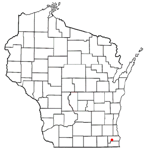
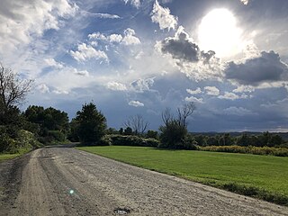
The Town of Dover is located in Racine County, Wisconsin, United States. The population was 4,282 at the 2020 census. The unincorporated communities of Beaumont, Eagle Lake Manor, Eagle Lake Terrace, Kansasville, and Rosewood are located in the town. The census-designated place of Eagle lake is also located in the town.

<span class="mw-page-title-main">Windsor, Missouri</span> City in Missouri, United States

Windsor is a city in Henry and Pettis counties, Missouri, United States. The population was 2,901 at the 2010 census.

<span class="mw-page-title-main">East Millinocket, Maine</span> Town in the state of Maine, United States

East Millinocket is a town in Penobscot County, Maine, United States. The population was 1,572 at the 2020 census.

<span class="mw-page-title-main">Anson, Maine</span> Town in the state of Maine, United States

Anson is a town in Somerset County, Maine, United States. The population was 2,291 at the time of the 2020 census. It includes the villages of Anson and North Anson.

References

  1. 1 2 "US Gazetteer files 2010". United States Census Bureau. Archived from the original on January 25, 2012. Retrieved August 5, 2014.
  2. 1 2 "US Board on Geographic Names". United States Geological Survey. October 25, 2007. Retrieved January 31, 2008.
  3. 1 2 "U.S. Census website". United States Census Bureau. Retrieved August 5, 2014.
  4. 1 2 "U.S. Census website". United States Census Bureau . Retrieved January 31, 2008.