Related Research Articles

Howard County is a county located in the US state of Iowa. As of the 2020 census, the population was 9,469. The county seat is Cresco. The county was founded in 1851; it was named for General Tilghman Ashurst Howard, a Representative of Indiana.

Beedeville is a town in Jackson County, Arkansas, United States. The population was 107 at the 2010 census.

Emington is a village in Livingston County, Illinois, United States. The population was 117 at the 2010 census.

Wanatah is a town in LaPorte County, Indiana, United States. The population was 1,048 at the 2010 census.
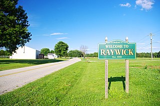
Raywick is a home rule-class city in Marion County, Kentucky, United States. The population was 144 at the 2000 census.

Clover Hill is an unincorporated community and former census-designated place (CDP) in Frederick County, Maryland, United States. The population was 3,260 at the 2000 census. The area was not listed as a CDP for the 2010 census, and no population total was published.

Chaparral is an unincorporated community and census-designated place (CDP) in Doña Ana and Otero counties, New Mexico. The population was 14,631 at the 2010 census. Chaparral is primarily a bedroom community for the neighboring city of El Paso, Texas, and the neighboring military installations of White Sands Missile Range and Fort Bliss. It is officially part of the Las Cruces Metropolitan Statistical Area.
Burns is a town in Allegany County, New York, United States. The population was 1,045 at the 2020 census. The town is named after Scots poet Robert Burns.
Bloomfield is a village in Ontario County, New York, United States. The population was 1,361 at the 2010 census.

West Babylon is a census-designated place (CDP) in the Town of Babylon in Suffolk County, New York, United States. The population was 43,213 at the 2010 census.

Cofield is a village in Hertford County, North Carolina, United States. The population was 413 at the 2010 census.
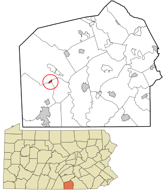
Orrtanna is a census-designated place (CDP) in Adams County, Pennsylvania, United States. The population was 183 at the 2020 census.

Freedom Township is a township in Blair County, Pennsylvania, United States. It is part of the Altoona, PA Metropolitan Statistical Area. The population was 3,018 at the 2020 census.

Benson is a borough in Somerset County, Pennsylvania, United States. The town is more commonly known to locals as Hollsopple, which is also the United States Postal Service name for the town, zip code 15935. The population was 185 at the 2020 census. It is part of the Johnstown, Pennsylvania Metropolitan Statistical Area. Benson is served by the Conemaugh Township Area School District.
Dalzell is a census-designated place (CDP) in Sumter County, South Carolina, United States. The population was 3,175 at the 2020 census. It is included in the Sumter, South Carolina Metropolitan Statistical Area.
Larga Vista is a former census-designated place (CDP) in Webb County, Texas, United States. The population was 742 at the 2000 census. Larga Vista lost its census-designated place status in 2010 because it became surrounded by Laredo, Texas. A CDP may not be located, either partially or entirely, within an incorporated place or another CDP. Today, Larga Vista is considered a Laredo neighborhood.

Portageville is a city in New Madrid and Pemiscot counties in the U.S. state of Missouri. The population was 2,942 according to the 2020 Census.

Concorde Hills is a census-designated place (CDP) in Sycamore Township, Hamilton County, Ohio, United States. The population was 663 at the 2010 census.
Northwood is a census-designated place in Snyder Township, Blair County, Pennsylvania, United States. It is located near I-99 and is very close to the borough of Tyrone. As of the 2010 census, the population was 296 residents.
Nelson is a census-designated place (CDP) in Pima County, Arizona, United States. The population was 259 at the 2010 census.
References
- ↑ "ArcGIS REST Services Directory". United States Census Bureau. Retrieved October 12, 2022.
- ↑ "Census Population API". United States Census Bureau. Retrieved Oct 12, 2022.
- ↑ "Census of Population and Housing". Census.gov. Retrieved June 4, 2016.
