Greenfield Township, Blair County, Pennsylvania

Last updated

Greenfield Township,
Blair County,
Pennsylvania
The Head 1.jpg
Schaefer Head, Blair County's highest point
Map of Greenfield Township, Blair County, Pennsylvania Highlighted.png
Map of Blair County, Pennsylvania highlighting Greenfield Township
Map of Pennsylvania highlighting Blair County.svg
Map of Blair County, Pennsylvania
Country United States
State Pennsylvania
County Blair
Settled1770
Incorporated1846
Government
  TypeBoard of Supervisors
Area
[1]
  Total36.25 sq mi (93.89 km2)
  Land36.25 sq mi (93.89 km2)
  Water0.00 sq mi (0.00 km2)
Population
 (2020) [2]
  Total3,785 Decrease2.svg
  Estimate 
(2022) [2]
3,715
  Density111.81/sq mi (43.17/km2)
Time zone UTC-5 (Eastern (EST))
  Summer (DST) UTC-4 (EDT)
Area code 814
FIPS code 42-013-31000
Website www.greenfieldtownshippa.gov

Greenfield Township is a township in Blair County, Pennsylvania, United States. It is part of the Altoona, PA Metropolitan Statistical Area. The population was 3,785 at the 2020 census. [2]

Contents

General information

Geography

Greenfield Township is located in the southwestern corner of Blair County. It is bordered by Juniata Township and Freedom Township to the north and by Taylor Township to the northeast. Bedford County is to the south, and specifically Bloomfield Township to the southeast, Kimmel Township to the south, and Pavia Township to the southwest. Cambria County is to the west, with Summerhill Township touching Greenfield Township at its southwest corner and Portage Township sharing the western border.

The unincorporated community of Claysburg is the primary settlement in Greenfield Township, occupying the valley of the Frankstown Branch of the Juniata River near the eastern edge of the township. Interstate 99 passes to the east of Claysburg along the side of Dunning Mountain, with access from Exit 15 near the southern edge of the township. Other communities in the township include Ski Gap, Klahr, Friesville, Cotton Town, and Sproul.

According to the United States Census Bureau, the township has a total area of 36.3 square miles (93.9 km2), all land. [3]

Recreation

A portion of the Pennsylvania State Game Lands Number 26 is located in the western portion of the township, and three small parcels of Game Lands Number 41 are located in the southwestern corner of the township. [4] [5]

Demographics

Historical population
CensusPop.Note
1970 3,543
1980 3,7586.1%
1990 3,8021.2%
2000 3,9042.7%
2010 4,1736.9%
2020 3,785−9.3%
2022 (est.)3,715 [2] −1.8%
U.S. Decennial Census [6]

As of the census [7] of 2000, there were 3,904 people, 1,549 households, and 1,115 families residing in the township. The population density was 108.7 inhabitants per square mile (42.0/km2). There were 1,697 housing units at an average density of 47.3 per square mile (18.3/km2). The racial makeup of the township was 98.95% White, 0.15% African American, 0.08% Native American, 0.03% Asian, 0.18% from other races, and 0.61% from two or more races. Hispanic or Latino of any race were 0.36% of the population.

There were 1,549 households, out of which 32.7% had children under the age of 18 living with them, 52.9% were married couples living together, 13.6% had a female householder with no husband present, and 28.0% were non-families. 24.5% of all households were made up of individuals, and 11.3% had someone living alone who was 65 years of age or older. The average household size was 2.51 and the average family size was 2.96.

In the township the population was spread out, with 24.6% under the age of 18, 9.3% from 18 to 24, 27.7% from 25 to 44, 24.5% from 45 to 64, and 13.9% who were 65 years of age or older. The median age was 37 years. For every 100 females there were 91.6 males. For every 100 females age 18 and over, there were 89.9 males.

The median income for a household in the township was $27,790, and the median income for a family was $31,902. Males had a median income of $30,156 versus $17,449 for females. The per capita income for the township was $14,168. About 14.1% of families and 16.6% of the population were below the poverty line, including 20.6% of those under age 18 and 17.0% of those age 65 or over.

Related Research Articles

<span class="mw-page-title-main">Blair County, Pennsylvania</span> County in Pennsylvania, United States

Blair County is a county in the Commonwealth of Pennsylvania. As of the 2020 census, the population was 122,822. Its county seat is Hollidaysburg, and its largest city is Altoona. The county was created on February 26, 1846, from parts of Huntingdon and Bedford counties. The county is part of the Southwest Pennsylvania region of the state.

<span class="mw-page-title-main">Bloomfield Township, Bedford County, Pennsylvania</span> Township in Pennsylvania, United States

Bloomfield Township is a township in Bedford County, Pennsylvania, United States. The population was 1,039 at the 2020 census.

<span class="mw-page-title-main">Broad Top Township, Pennsylvania</span> Township in Pennsylvania, United States

Broad Top Township is a township in Bedford County, Pennsylvania, United States. The population was 1,441 at the 2020 census.

<span class="mw-page-title-main">Hopewell Township, Bedford County, Pennsylvania</span> Township in Pennsylvania, United States

Hopewell Township is a township in Bedford County, Pennsylvania, United States. The population was 1,890 at the 2020 census.

<span class="mw-page-title-main">Juniata Township, Bedford County, Pennsylvania</span> Township in Pennsylvania, United States

Juniata Township is a township that is located in Bedford County, Pennsylvania, United States. The population was 901 at the time of the 2020 census.

<span class="mw-page-title-main">Londonderry Township, Bedford County, Pennsylvania</span> Township in Pennsylvania, United States

Londonderry Township is a township in Bedford County, Pennsylvania, United States. It is named after County Londonderry, now in Northern Ireland. The population was 1,643 at the 2020 census.

<span class="mw-page-title-main">Pavia Township, Pennsylvania</span> Township in Pennsylvania, United States

Pavia Township is a township that is located in Bedford County, Pennsylvania, United States. The population was 287 at the time of the 2020 census.

<span class="mw-page-title-main">West Providence Township, Pennsylvania</span> Township in Pennsylvania, United States

West Providence Township is a township in Bedford County, Pennsylvania, United States. The population was 3,078 at the 2020 census.

<span class="mw-page-title-main">Allegheny Township, Blair County, Pennsylvania</span> Township in Pennsylvania, United States

Allegheny Township is a township in Blair County, Pennsylvania, United States. The population was 6,585 at the 2020 census. It is part of the Altoona, Pennsylvania Metropolitan Statistical Area.

<span class="mw-page-title-main">Blair Township, Pennsylvania</span> Township in Pennsylvania, United States

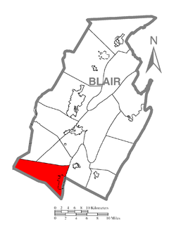
Blair Township is a township in Blair County, Pennsylvania, United States. The population was 4,785 at the 2020 census.

<span class="mw-page-title-main">Catharine Township, Pennsylvania</span> Township in Pennsylvania, United States

Catharine Township is a township in Blair County, Pennsylvania, United States. The population was 773 at the 2020 census. It is part of the Altoona, PA Metropolitan Statistical Area.

<span class="mw-page-title-main">Frankstown Township, Blair County, Pennsylvania</span> Township in Pennsylvania, United States

Frankstown Township is a township in Blair County, Pennsylvania, United States. It is part of the Altoona Metropolitan Statistical Area. The population was 7,399 at the 2020 census. The township was named after Stephen Franks, a pioneer citizen.

<span class="mw-page-title-main">Freedom Township, Blair County, Pennsylvania</span> Township in Pennsylvania, United States

Freedom Township is a township in Blair County, Pennsylvania, United States. It is part of the Altoona, PA Metropolitan Statistical Area. The population was 3,005 at the 2020 census.

<span class="mw-page-title-main">Huston Township, Blair County, Pennsylvania</span> Township in Pennsylvania, United States

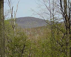
Huston Township is a township in Blair County, Pennsylvania, United States. It is part of the Altoona, PA Metropolitan Statistical Area. The population was 1,247 at the 2020 census.

<span class="mw-page-title-main">Juniata Township, Blair County, Pennsylvania</span> Township in Pennsylvania, United States

Juniata Township is a township in Blair County, Pennsylvania, United States. It is part of the Altoona, PA Metropolitan Statistical Area. The population was 965 at the 2020 census.

<span class="mw-page-title-main">North Woodbury Township, Pennsylvania</span> Township in Pennsylvania, United States

North Woodbury Township is a township in Blair County, Pennsylvania, United States. It is part of the Altoona, PA Metropolitan Statistical Area. The population was 2,434 at the 2020 census.

<span class="mw-page-title-main">Snyder Township, Blair County, Pennsylvania</span> Township in Pennsylvania, United States

Snyder Township is a township in Blair County, Pennsylvania, United States. It is part of the Altoona, PA Metropolitan Statistical Area. The population was 3,345 at the 2020 census.

<span class="mw-page-title-main">Tyrone Township, Blair County, Pennsylvania</span> Township in Pennsylvania, United States

Tyrone Township is a township in Blair County, Pennsylvania, United States. It is part of the Altoona, PA Metropolitan Statistical Area. The population was 1,873 at the 2020 census.

<span class="mw-page-title-main">Woodbury Township, Blair County, Pennsylvania</span> Township in Pennsylvania, United States

Woodbury Township is a township in Blair County, Pennsylvania, United States. It is part of the Altoona, PA Metropolitan Statistical Area. The population was 1,438 at the 2020 census.

<span class="mw-page-title-main">North Newton Township, Pennsylvania</span> Township in Pennsylvania, United States

North Newton Township is a township in Cumberland County, Pennsylvania, United States. The population was 2,546 at the 2020 census.

References

  1. "2016 U.S. Gazetteer Files". United States Census Bureau. Retrieved 13 August 2017.
  2. 1 2 3 4 Bureau, US Census. "City and Town Population Totals: 2020-2022". Census.gov. US Census Bureau. Retrieved 5 March 2024.
  3. "Geographic Identifiers: 2010 Demographic Profile Data (G001): Greenfield township, Blair County, Pennsylvania". U.S. Census Bureau, American Factfinder. Archived from the original on 12 February 2020. Retrieved 11 March 2014.
  4. https://viewer.nationalmap.gov/advanced-viewer/ The National Map, retrieved 3 October 2018
  5. Pennsylvania State Game Lands Number 26, retrieved 3 October 2018
  6. "Census of Population and Housing". Census.gov. Retrieved 4 June 2016.
  7. "U.S. Census website". United States Census Bureau . Retrieved 31 January 2008.

40°14′56″N78°26′59″W / 40.24889°N 78.44972°W / 40.24889; -78.44972