Greater Western Sydney (GWS) is a large region of the metropolitan area of Greater Sydney, New South Wales (NSW), Australia that generally embraces the north-west, south-west, central-west, far western and the Blue Mountains sub-regions within Sydney's metropolitan area and encompasses 11 local government areas: Blacktown, Blue Mountains, Camden, Campbelltown, Cumberland, Fairfield, Hawkesbury, Liverpool, Parramatta, Penrith and Wollondilly. It includes Western Sydney, which has a number of different definitions, although the one consistently used is the region composed of ten local government authorities, most of which are members of the Western Sydney Regional Organisation of Councils (WSROC). The NSW Government's Office of Western Sydney calls the region "Greater Western Sydney".

Fairfield is a suburb of Western Sydney, in the state of New South Wales, Australia. Being in the centre of the Cumberland Plain, Fairfield is located 30 kilometres (19 mi) west of the Sydney central business district and is the administrative heart of the Fairfield City Council – despite a very small portion of it belonging to the Cumberland Council. Fairfield supports a mixture of commercial and residential developments, mostly characterised by medium-density buildings and some new high-rise apartments.

Smithfield is a suburb of Sydney, in the state of New South Wales, Australia. Smithfield is located 31 kilometres (19 mi) west of the Sydney central business district, in the local government areas of the City of Fairfield and Cumberland Council. Located in the Greater Western Sydney region, the suburb is one of the largest in Fairfield City by area.

Prospect Creek is an urban watercourse of the Georges River catchment that is located in the western region of Sydney, in New South Wales, Australia. As Prospect Reservoir forms a part of the Sydney metropolitan water supply, the flow of the creek is regulated in accordance with the operational requirements of Sydney Water.
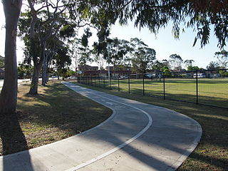
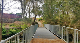
Bike paths in Sydney, New South Wales, Australia, vary widely, with the majority either shared cycle and pedestrian paths or on road paths, and a small number of separated cycleways. In 2009 the Sydney Morning Herald reported that "Sydney's cycleways are not so much an organised network as a fragmented collection of winding paths and half-finished ideas. Most were built or designed when cycling was viewed as a pleasant pastime rather than a practical form of travel and are now poorly suited to commuting."

Chipping Norton Lake is a 49-hectare (120-acre) artificial lake and regional park located in the Sydney suburb of Chipping Norton, New South Wales, Australia. It is a part of the Georges River system. Chipping Norton Lake is managed by Liverpool City Council. The lake is an important recreational area for Liverpool, City of Canterbury-Bankstown and Fairfield City Council.
The Western Sydney Parklands is an urban park system and a nature reserve located in Sydney, New South Wales, Australia. The NSW government has spent around $400 million for the park. The park is governed by the NSW National Parks and Wildlife Service and is listed under the National Parks and Wildlife Act 1974. The Parklands begin in the north in the City of Blacktown, cross the City of Fairfield, and end in the City of Liverpool.

Western Sydney Regional Park is a large urban park and a nature reserve situated in Western Sydney, Australia within the suburbs of Horsley Park and Abbotsbury. A precinct of Western Sydney Parklands, a park system, and situated within the heart of the Cumberland Plain Woodland, the regional park features several picnic areas, recreational facilities, equestrian trails, and walking paths within the Australian bush.

The Central Gardens Nature Reserve, also called Central Gardens, is a protected nature reserve located in the western suburbs of Sydney, New South Wales, Australia. Established in 1976, the 12-hectare (30-acre) reserve, garden and fauna and wildlife park is situated in the suburb of Merrylands and is managed by Cumberland Council. The park is regionally important and it attracts visitors outside the Cumberland local government area. The bushland contains remnants of Cumberland Plain Woodland and is approximately 3.5 hectares.

Wetherill Park Nature Reserve, also called Wetherill Park Reserve, is an urban park and a nature reserve situated in the western suburbs of Sydney, New South Wales, Australia. The reserve contains an open woodland and bushland which feature native plants, such as eucalyptus trees, and recreational areas.

Brenan Park is a 20-hectare (49-acre) urban park situated in the western suburbs of Sydney, New South Wales, Australia. Primarily categorised as a sports field, the reserve contains an open grassland, bushland and recreational areas within the vicinity of native plants, such as eucalyptus trees. It is named after John Ryan Brenan, who founded the suburb of Smithfield in 1836.

Rosford Street Reserve, or Rosford Reserve, is an urban park and nature reserve situated in the western suburbs of Sydney, New South Wales, Australia. The reserve contains an open grassland, woodlands and recreational areas surrounded by native plants, such as eucalyptus trees. Janice Crosio Oval is a fenced sports ground incorporated within the reserve. The park is one of the largest in the Fairfield LGA area.

The Cumberland Plain Woodland, also known as Cumberland Plain Bushland and Western Sydney woodland, is a grassy woodland community found predominantly in Western Sydney, New South Wales, Australia, that comprises an open tree canopy, a groundcover with grasses and herbs, usually with layers of shrubs and/or small trees.
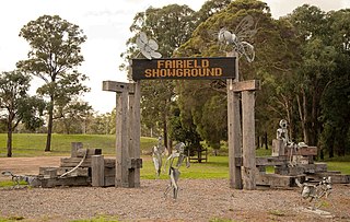
Fairfield Showground is a multi-purpose indoor-outdoor venue situated in Prairiewood, New South Wales, Australia. Since in the 1970s, it has been a popular venue for multicultural festivals, horse racing, carnivals, markets and club meets attracting as many as 20,000 people. Situated in western Sydney, the showground has around 10,000 sqm of undercover exhibition space and it is overall 33 hectares in size, with parking spaces for over 600 vehicles.
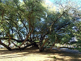
The Bland Oak, or Bland's Oak Tree, is a historic Southern live oak situated in Greater Western Sydney, New South Wales, Australia, that is approximately over 170 years old, making it one of Sydney's oldest living introduced trees and also one of the largest in the region. A local significance and a historic symbol of Fairfield City Council, the oak tree is included on Fairfield City's coat of arms.

St Leonards Park is a heritage-listed bowling club, 15-hectare (37-acre) urban park, rugby field and cricket oval at 283a Miller Street, North Sydney, North Sydney Council, New South Wales, Australia. It was designed by William Tunks, Mayor and built during 1838. It was added to the New South Wales State Heritage Register on 31 July 2015.
The Horsley Drive is a 13-kilometre (8.1 mi) urban sealed road located in the City of Fairfield in Greater Western Sydney, New South Wales, Australia. The road's northwestern terminus is located at the entrance of Western Sydney Parklands in Horsley Park and its southeastern terminus at its intersection with Hume Highway in Carramar.

Prospect Nature Reserve is a nature reserve and recreational area that is situated in the western suburbs of Sydney, New South Wales, Australia, which incorporates the Prospect Reservoir, and also features picnic spots, lookouts, walking tracks and BBQ areas within the Australian bush. It is located within the Blacktown City local government area, but is also close to the boundaries of Cumberland Council and the City of Fairfield.
The Lennox River is the proposed name for a waterway located in Sydney's South-Western Suburbs. The existing waterway is the tidal reach of Prospect Creek, a tributary of the Georges River. A proposal has been made to upgrade and reclassify the waterway as a 'river'. The proposed river would be 6.5 kilometres (4 mi) long, starting at the confluence of Orphan School Creek and Prospect Creek at Fairfield and flowing to the Georges River emptying into Dhurawal Bay at Garrison Point.

The Grey Box Reserve, or Greystanes Grey Box Reserve, is a small nature reserve situated in the suburb of Greystanes, New South Wales in Western Sydney, Australia. A remnant bushland of the Cumberland Plain Woodland, it mainly features native vegetation. The reserve is so-named because of its abundance of Eucalyptus moluccana, reflecting the pre-European cultural landscape of the area.