Forest County, Wisconsin

Last updated

Forest County
ForestCountyWisconsinCourthouseUS8WIS32WIS55.jpg
Forest County Courthouse
Map of Wisconsin highlighting Forest County.svg
Location within the U.S. state of Wisconsin
Wisconsin in United States.svg
Wisconsin's location within the U.S.
Coordinates: 45°40′N88°47′W / 45.67°N 88.78°W / 45.67; -88.78
CountryFlag of the United States.svg United States
StateFlag of Wisconsin.svg  Wisconsin
Founded1885
Seat Crandon
Largest cityCrandon
Area
  Total1,046 sq mi (2,710 km2)
  Land1,014 sq mi (2,630 km2)
  Water32 sq mi (80 km2)  3.1%
Population
 (2020) [1]
  Total9,179
  Density9.1/sq mi (3.5/km2)
Time zone UTC−6 (Central)
  Summer (DST) UTC−5 (CDT)
Congressional district 7th
Website www.co.forest.wi.gov

Forest County is a county in the U.S. state of Wisconsin. As of the 2020 census, the population was 9,179. [1] Its county seat is Crandon. [2] The Forest County Potawatomi Community and the Sokaogon Chippewa Community have reservations in Forest County.

Contents

History

Forest County was created by the Wisconsin State Legislature in 1885 from portions of neighboring Langlade and Oconto counties. [3] [4] The county was named for the forests contained within its limits. [5]

Geography

According to the U.S. Census Bureau, the county has a total area of 1,046 square miles (2,710 km2), of which 1,014 square miles (2,630 km2) is land and 32 square miles (83 km2) (3.1%) is water. [6] The second highest elevation in the state of Wisconsin is Sugarbush hill which is in Forest County. [7]

Adjacent counties

Major highways

Railroads

Buses

Airport

National protected area

Demographics

Historical population
CensusPop.Note
1890 1,012
1900 1,39637.9%
1910 6,782385.8%
1920 9,85045.2%
1930 11,11812.9%
1940 11,8056.2%
1950 9,437−20.1%
1960 7,542−20.1%
1970 7,6912.0%
1980 9,04417.6%
1990 8,776−3.0%
2000 10,02414.2%
2010 9,304−7.2%
2020 9,179−1.3%
U.S. Decennial Census [8]
1790–1960 [9] 1900–1990 [10]
1990–2000 [11] 2010 [12] 2020 [1]

2020 census

As of the census of 2020, [1] the population was 9,179. The population density was 9.1 people per square mile (3.5 people/km2). There were 8,604 housing units at an average density of 8.5 units per square mile (3.3 units/km2). The racial makeup of the county was 80.7% White, 13.4% Native American, 0.3% Black or African American, 0.2% Asian, 0.1% Pacific Islander, 0.2% from other races, and 5.1% from two or more races. Ethnically, the population was 1.7% Hispanic or Latino of any race.

2000 census

2000 Census Age Pyramid for Forest County USA Forest County, Wisconsin age pyramid.svg
2000 Census Age Pyramid for Forest County

As of the census [13] of 2000, there were 10,024 people, 4,043 households, and 2,769 families residing in the county. The population density was 10 people per square mile (3.9 people/km2). There were 8,322 housing units at an average density of 8 units per square mile (3.1 units/km2). The racial makeup of the county was 85.86% White, 11.30% Native American, 1.18% Black or African American, 0.17% Asian, 0.04% Pacific Islander, 0.23% from other races, and 1.22% from two or more races. 1.08% of the population were Hispanic or Latino of any race. 34.3% were of German, 11.4% Polish, 7.4% Irish and 5.4% American ancestry. 95.5% spoke English, 1.4% Spanish and 1.0% Potawatomi as their first language.

Out of the 4,043 households, 29.20% had children under the age of 18, 54.00% had a married couple living together, 9.80% had a female householder with no husband present, and 31.50% were non-families. 28.20% of all households were made up of individuals living alone, and 13.20%, of individuals of 65 years of age or older living alone. The average household size was 2.39 and the average family size was 2.89.

The age distribution in the county's population was as follows: 25.30% under the age of 18, 7.80% from 18 to 24, 23.90% from 25 to 44, 23.80% from 45 to 64, and 19.30% 65 years of age or older. The median age was 40 years. For every 100 females there were 100.20 males. For every 100 females age 18 and over, there were 99.00 males.

In 2017, there were 102 births, giving a general fertility rate of 71.1 births per 1000 women aged 15–44, the 14th highest rate out of all 72 Wisconsin counties. [14] There were fewer than five reported induced abortions performed on women of Forest County residence in 2017. [15]

Communities

Forest County sign on WIS 139 Forest County Wisconsin Sign WIS139.jpg
Forest County sign on WIS 139

City

Towns

Census-designated places

Unincorporated communities

Ghost towns/neighborhoods

Images

Politics

From its founding in 1885 until 1928, Forest County voted for the Republican candidate in all but three elections, voting for the Democratic candidate in 1892 and 1912, and voting for Progressive candidate and native Wisconsinite Robert M. La Follette in 1924. Then, from 1932 to 1996, the county voted Democratic in every election with the exception of four nationwide Republican landslides in 1952, 1956, 1972, and 1984. In 2000 and 2004, Forest County backed George W. Bush in both of his successful runs for the presidency, though doing so by less than 6% both times. The county shifted back to Democratic hands in 2008 and 2012, with Barack Obama taking the county in his two successful elections. However, since 2016, Forest County has shifted significantly to the right. In 2016, Donald Trump received over 61% of the vote in the county, the highest any candidate has received since 1964, winning by over 26% against Hillary Clinton. Trump further improved on his numbers in 2020, taking over 65% of the county's vote and winning by a margin of over 30% against Joe Biden, turning in the best performance by a Republican in Forest County since Warren G. Harding a century earlier.

United States presidential election results for Forest County, Wisconsin [16]
Year Republican Democratic Third party
No.%No.%No.%
2020 3,28565.01%1,72134.06%470.93%
2016 2,78761.32%1,57934.74%1793.94%
2012 2,17246.73%2,42552.17%511.10%
2008 1,96341.92%2,67357.08%471.00%
2004 2,60850.61%2,50948.69%360.70%
2000 2,40450.98%2,15845.76%1543.27%
1996 1,16629.41%2,09252.76%70717.83%
1992 1,39331.89%1,90443.59%1,07124.52%
1988 1,84546.02%2,14253.43%220.55%
1984 2,29650.53%2,21448.72%340.75%
1980 2,07044.29%2,40251.39%2024.32%
1976 1,60437.84%2,57460.72%611.44%
1972 1,85649.77%1,67845.00%1955.23%
1968 1,26440.14%1,47046.68%41513.18%
1964 1,06930.10%2,47969.79%40.11%
1960 1,65347.04%1,85152.68%100.28%
1956 2,03957.03%1,52742.71%90.25%
1952 1,99052.47%1,79147.22%120.32%
1948 1,25135.11%2,20861.97%1042.92%
1944 1,39136.22%2,43663.44%130.34%
1940 1,67236.04%2,95163.61%160.34%
1936 1,33429.42%3,09268.18%1092.40%
1932 76822.50%2,59576.03%501.46%
1928 1,91852.82%1,67746.19%360.99%
1924 1,10440.74%29911.03%1,30748.23%
1920 1,42975.13%37919.93%944.94%
1916 73852.19%63745.05%392.76%
1912 51838.37%56742.00%26519.63%
1908 1,02371.69%32422.70%805.61%
1904 99182.51%16013.32%504.16%
1900 37876.83%9519.31%193.86%
1896 40668.01%17228.81%193.18%
1892 22347.35%22848.41%204.25%

See also

Related Research Articles

<span class="mw-page-title-main">Vilas County, Wisconsin</span> County in Wisconsin, United States

Vilas County is a county in the state of Wisconsin, United States. As of the 2020 census, the population was 23,047. Its county seat is Eagle River. The county partly overlaps the reservation of the Lac du Flambeau Band of Lake Superior Chippewa.

<span class="mw-page-title-main">Shawano County, Wisconsin</span> County in Wisconsin, United States

Shawano County is a county located in the U.S. state of Wisconsin. As of the 2020 census, the population was 40,881. Its county seat is Shawano.

<span class="mw-page-title-main">Richland County, Wisconsin</span> County in Wisconsin, United States

Richland County is a county in the U.S. state of Wisconsin. As of the 2020 census, the population was 17,304. Its county seat is Richland Center. The county was created from the Wisconsin Territory in 1842 and organized in 1850. It is named for the high quality of its soil.

<span class="mw-page-title-main">Portage County, Wisconsin</span> County in Wisconsin, United States

Portage County is a county in the U.S. state of Wisconsin. As of the 2020 census, the population was 70,377. Its county seat is Stevens Point.

<span class="mw-page-title-main">Oneida County, Wisconsin</span> County in Wisconsin, United States

Oneida County is a county in the state of Wisconsin, United States. At the 2020 census, the population was 37,845. Its county seat is Rhinelander.

<span class="mw-page-title-main">Oconto County, Wisconsin</span> County in Wisconsin, United States

Oconto County is a county in the U.S. state of Wisconsin. As of the 2020 census, the population was 38,965. Its county seat is Oconto. The county was established in 1851.

<span class="mw-page-title-main">Menominee County, Wisconsin</span> County in Wisconsin, United States

Menominee County is a county in the U.S. state of Wisconsin. As of the 2020 census, the population was 4,255, making it the least populous county in Wisconsin. Its county seat is in the community of Keshena.

<span class="mw-page-title-main">Marinette County, Wisconsin</span> County in Wisconsin, United States

Marinette County is a county in the U.S. state of Wisconsin. As of the 2020 census, the population was 41,872. Its county seat is Marinette. Marinette County is part of the Marinette, WI–MI Micropolitan Statistical Area.

<span class="mw-page-title-main">Lincoln County, Wisconsin</span> County in Wisconsin, United States

Lincoln County is a county located in the U.S. state of Wisconsin. As of the 2020 census, the population was 28,415. Its county seat is Merrill. The county was created in 1875 and named after President Abraham Lincoln.

<span class="mw-page-title-main">Langlade County, Wisconsin</span> County in Wisconsin, United States

Langlade County is a county located in the U.S. state of Wisconsin. As of the 2020 census, the population was 19,491. Its county seat is Antigo.

<span class="mw-page-title-main">Florence County, Wisconsin</span> County in Wisconsin, United States

Florence County is a county located in the U.S. state of Wisconsin. As of the 2020 census, the population was 4,558, making it the second-least populous county in Wisconsin after Menominee County. Its county seat is Florence.

<span class="mw-page-title-main">Eau Claire County, Wisconsin</span> County in Wisconsin, United States

Eau Claire County is a county located in the U.S. state of Wisconsin. As of the 2020 census, the population was 105,710. Its county seat is Eau Claire. The county took its name from the Eau Claire River.

<span class="mw-page-title-main">Dunn County, Wisconsin</span> County in Wisconsin, United States

Dunn County is a county in the U.S. state of Wisconsin. As of the 2020 census, the population was 45,440. Its county seat is Menomonie. Dunn County comprises the Menomonie Micropolitan Statistical Area and is included in the Eau Claire-Menomonie, WI Combined Statistical Area.

<span class="mw-page-title-main">Caswell, Wisconsin</span> Town in Wisconsin, United States

Caswell is a town in Forest County, Wisconsin, United States. The population was 91 at the 2010 census. The unincorporated communities of Cavour and Laona Junction are located within the town. The ghost town of Bagdad was located in the town.

<span class="mw-page-title-main">Wabeno, Wisconsin</span> Town in Wisconsin, United States

Wabeno is a town in Forest County, Wisconsin, United States. The population was 1,166 at the 2010 census. The census-designated place of Wabeno and the unincorporated communities of Carter, Padus, and Soperton are located in the town. Wabeno is situated within Wisconsin's 7th congressional district.

<span class="mw-page-title-main">Langlade, Wisconsin</span> Town in Wisconsin, United States

Langlade is a town in Langlade County, Wisconsin, United States. The population was 473 at the 2010 census. The unincorporated communities of Choate, Freeman, Lily, and Pickerel are located within the town. The township is served by the Town of Langlade Fire Department, and Pickerel Rescue Squad for ambulance services.

<span class="mw-page-title-main">Wolf River, Langlade County, Wisconsin</span> Town in Wisconsin, United States

Wolf River is a town in Langlade County, Wisconsin, United States. The population was 731 at the 2010 census, down from 856 at the 2000 census. The unincorporated communities of Hollister, Langlade, and Markton and the ghost town of Van Ostrand are in the town. The village of White Lake, a separate municipality, is surrounded by the town. The township is served by the Wolf River Volunteer Fire Department.

<span class="mw-page-title-main">Crandon, Wisconsin</span> City in Wisconsin, United States

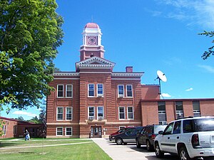
Crandon is a city in Forest County, Wisconsin, United States; it is in the northeastern part of the state, about 100 miles (160 km) north of Green Bay. The population was 1,713 at the 2020 census. It is the county seat of Forest County and is the only incorporated community in the county. The city is located adjacent to the Town of Crandon.

<span class="mw-page-title-main">Oconto, Wisconsin</span> City in Wisconsin, United States

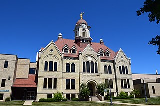
Oconto is a city and county seat of Oconto County, Wisconsin, United States. The population was 4,609 at the 2020 census. It is part of the Green Bay Metropolitan Statistical Area. The city is located partially within the town of Oconto.

<span class="mw-page-title-main">Forest County Potawatomi Community</span>

The Forest County Potawatomi Community is a federally recognized tribe of Potawatomi people with approximately 1,400 members as of 2010. The community is based on the Forest County Potawatomi Indian Reservation, which consists of numerous non-contiguous plots of land in southern Forest County and northern Oconto County, Wisconsin, United States. The community also administers about 7 acres (28,000 m2) of off-reservation trust land in the city of Milwaukee. According to the U.S. Census Bureau, the reservation and off-reservation trust land together have a total area of 22.72 square miles (58.8 km2). The combined population of Forest County Potawatomi Community and Off-Reservation Trust Land was 594 in the 2020 census. The nation's administrative and cultural center are located about three miles east of Crandon, Wisconsin.

References

  1. 1 2 3 4 "2020 Decennial Census: Forest County, Wisconsin". data.census.gov. U.S. Census Bureau. Retrieved July 12, 2022.
  2. "Find a County". National Association of Counties. Archived from the original on May 31, 2011. Retrieved June 7, 2011.
  3. "Forest County, Wis., government website" . Retrieved November 24, 2014.
  4. "Wisconsin: Individual County Chronologies". Wisconsin Atlas of Historical County Boundaries. The Newberry Library. 2007. Archived from the original on April 14, 2017. Retrieved August 13, 2015.
  5. Gannett, Henry (1905). The Origin of Certain Place Names in the United States. Govt. Print. Off. pp.  128.
  6. "2010 Census Gazetteer Files". United States Census Bureau. August 22, 2012. Retrieved August 4, 2015.
  7. Dawson, Drew (August 14, 2023). "These are the 10 tallest peaks in Wisconsin". Journal Sentinel. Journal Sentinel. Retrieved November 5, 2023.
  8. "U.S. Decennial Census". United States Census Bureau. Retrieved August 4, 2015.
  9. "Historical Census Browser". University of Virginia Library. Retrieved August 4, 2015.
  10. Forstall, Richard L., ed. (March 27, 1995). "Population of Counties by Decennial Census: 1900 to 1990". United States Census Bureau. Retrieved August 4, 2015.
  11. "Census 2000 PHC-T-4. Ranking Tables for Counties: 1990 and 2000" (PDF). United States Census Bureau. April 2, 2001. Archived (PDF) from the original on October 9, 2022. Retrieved August 4, 2015.
  12. "State & County QuickFacts". United States Census Bureau. Archived from the original on June 6, 2011. Retrieved January 18, 2014.
  13. "U.S. Census website". United States Census Bureau . Retrieved May 14, 2011.
  14. "Annual Wisconsin Birth and Infant Mortality Report, 2017 P-01161-19 (June 2019): Detailed Tables". Archived from the original on June 19, 2019. Retrieved June 19, 2019.
  15. Reported Induced Abortions in Wisconsin, Office of Health Informatics, Division of Public Health, Wisconsin Department of Health Services. Section: Trend Information, 2013-2017, Table 18, pages 17-18
  16. Leip, David. "Dave Leip's Atlas of U.S. Presidential Elections". uselectionatlas.org. Retrieved February 8, 2021.

Further reading

45°40′N88°47′W / 45.67°N 88.78°W / 45.67; -88.78