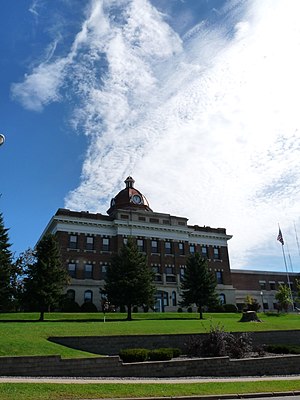
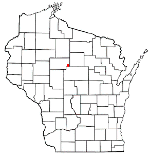
Taylor County is a county in the U.S. state of Wisconsin. As of the 2020 census, the population was 19,913.[1] Its county seat is Medford.[2] It is mostly rural, lying roughly where corn and dairy farms to the south give way to forest and swamp to the north.[3]
The earliest recorded event in Taylor county probably occurred in 1661, when Wisconsin was claimed by New France. A band of Huron Indians from eastern Ontario had fled the Iroquois and taken refuge near the headwaters of the Black River, probably around Lake Chelsea in the northeast part of the county. Father René Menard, a French Jesuit priest who had travelled up the Great Lakes as far as Keweenaw Bay in upper Michigan, heard that these Hurons were starving. He decided to try to reach them to baptize them, despite his own weak health and scant supplies. In mid-summer he and a French fur trader set out, following rivers and streams in birchbarkcanoes down into Wisconsin. Finally, a day's journey from the Huron camp, Father Menard separated from his travelling companion at a rapids to carry some supplies. He was never seen again. The place where he disappeared is believed to be the dells of the Big Rib River, below Goodrich in the southeast corner of Taylor county.[4]
A crew hauling logs for the Fountain-Campbell Lumber Company in northwest Taylor County, 1909
On June 8, 1847, before any settlers or loggers, a team of surveyors entered the county[5] southwest of Medford, where County E now enters from Clark County. They were working for the U.S. government, marking a north–south line called the Fourth Principal Meridian, from which much of the land in the state would be measured. For six days they worked their way through woods and swamps, up what is now the southern part of E and across the valley that is now the Mondeaux Flowage, before continuing north into what is now Price County. The head of the team wrote of the trip:
During four consecutive weeks there was not a dry garment in the party, day or night... we were constantly surrounded and as constantly excoriated by swarms or rather clouds of mosquitoes, and still more troublesome insects...[6]
On their way through the county, they and other surveyors recorded a forest then dominated by hemlock, yellow birch and sugar maple, with white pine the fourth or sixth most frequent. The mix of tree species then resembled today's Gerstberger Pines grove southeast of Rib Lake.[7]
Logging began in the late 1850s. Loggers came up the rivers and floated white pine logs out in spring and early summer log drives, down the Big Rib River into the Wisconsin River, down the Black River to the south, and west down the Jump and the Yellow River into the Chippewa. Log-drives continued until around 1900, when the easy-to-float white pine was dwindling.[8]
In 1872 and 73 the Wisconsin Central Railroad built its line up through the forest that would become Medford on its way to Ashland. The Wisconsin Central's financiers were from Boston, and they named stations at Medford, Chelsea and Westboro after towns in Massachusetts. To finance building this line, the U.S. Government gave the railroad half the land, the odd-numbered sections, of a good share of the county.[9] The railroad began to haul out the logs that didn't float well. Most early settlement was along this railroad, with few settlers in the west or east ends of the county even by the 1890s.[10]
In 1875 Taylor County with its current boundaries was carved out of the larger Chippewa, Lincoln and Clark counties and a bit of Marathon, with the county seat at Medford. The county was probably named for Wisconsin's governor at the time, William Robert Taylor. It was initially divided into four towns—Westboro, Chelsea, Medford and Little Black[11]—each stretching the width of the county.[12]
Mondeaux Dam Recreation Area, in the Chequamegon National Forest, in the north-central part of the county
From around 1902 to 1905 the Stanley, Merrill and Phillips Railway built its railroad up the west end of the county through Polley, Gilman, Hannibal and Jump River. In 1902 the Eau Claire, Chippewa Falls, and Northeastern Railroad (better known as Omaha) pushed in from Holcombe through Hannibal to now-abandoned Hughey on the Yellow River. In 1905 the Wisconsin Central Railroad built its line through Clark (now a ghost town), Lublin, Polley, Gilman and Donald, heading for Superior. The SM&P and Omaha were primarily logging railroads, which hauled out lumber and incidentally transported passengers and other cargo. With the lumber gone, the SM&P shut down in 1933.[13]
After the good timber was gone, the lumber companies sold many of the cutover forties to farm families. Initially they tried making their living in various ways: selling milk, eggs, beef and wool, growing cucumbers and peas, and various other schemes. But before long dairy had become the predominant form of agriculture in the county. By 1923 Medford had the second largest co-op creamery in Wisconsin. The number of dairy farms peaked around 3,300 in the early 1940s and had dropped to 1,090 by 1995.[14]
Much of the cut-over north-central part of the county was designated part of the Chequamegon National Forest in 1933.[15] Large chunks of this central and northern part of the county was not good for farming, and lay neglected in the hands of lumber companies after the forest was cut off - largely a tax-delinquent fire hazard. In the early 1930s the federal government agreed to manage the land for the county as National Forest.[16] Soon after, Civilian Conservation Corps camps at Mondeaux, Perkinstown, and near the current Jump River fire tower began to replant parts of that cutover. The CCCs at Mondeaux built the recreation area there.[17] Today hikers can follow the Ice Age National Scenic Trail through the national forest and the northeast corner of the county.
A farm in Taft in December
The major early industry was the production of sawlogs, lumber, and shingles.[18] Large sawmills were at Medford and Rib Lake. Medford, Perkinstown and Rib Lake had tanneries, which used local hemlock bark in the tanning process. Whittlesey had an early brickyard.[10] Industry has diversified since, into creameries, window manufacturers, plastics, and food processing - mostly at Medford.
Geography
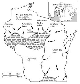
Maximum extent of the Laurentide Ice Sheet
According to the U.S. Census Bureau, the county has a total area of 984 square miles (2,550km2), of which 975 square miles (2,530km2) is land and 9.5 square miles (25km2) (1.0%) is water.[20]
Glacial landforms of Taylor County.
Taylor county's terrain was shaped chiefly by glaciers. Geologists believe that 15,000 to 25,000 years ago the Laurentide Ice Sheet pushed down from Canada across what are now the Great Lakes, and over much of the northern U.S. One of the ice sheet's lobes bulldozed down over two thirds of Taylor county, at its farthest extent covering a line from Westboro through Perkinstown to Lublin. The ice sheet pushed down that far, then melted back, leaving the band of choppy hills and little lakes that cuts diagonally across the county. This band of hills is called the Perkinstown terminal moraine. North and west of the moraine, in the corner of the county toward Jump River, that last glacier left behind a more gently rolling plain of glacial till. The striking glacial features in this area are glacial erratic boulders and eskers. Along with the Mondeaux and Lost Lake eskers, there are others in the towns of Westboro, Pershing, Aurora and Taft. The southeast corner of the county toward Stetsonville and Goodrich was not covered by the last glacier, but was covered by earlier ones. Here too they left glacial till, but the land is generally flatter and less rocky since erosion has had more time to level things.[19]
Beneath the glacial till lies Cambrian and Precambrianbedrock. Outcrops have been exposed in places by the Jump and Yellow Rivers.[14][19] An unmined copper and gold deposit known as the Bend deposit lies north of Perkinstown,[21] which geologists believe was formed up to two billion years ago by a black smoker, a volcanic vent under an ancient ocean.[22]
As of the census of 2020,[1] the population was 19,913. The population density was 20.4 peopleper square mile (7.9 people/km2). There were 9,379 housing units at an average density of 9.6 unitsper square mile (3.7 units/km2). The racial makeup of the county was 94.8% White, 0.3% Black or African American, 0.3% Asian, 0.2% Native American, 1.3% from other races, and 3.0% from two or more races. Ethnically, the population was 2.8% Hispanic or Latino of any race.
2000 census
2000 Census Age Pyramid for Taylor County
As of the census[28] of 2000, there were 19,680 people, 7,529 households, and 5,345 families residing in the county. The population density was 20 peopleper square mile (7.7 people/km2). There were 8,595 housing units at an average density of 9 unitsper square mile (3.5 units/km2). The racial makeup of the county was 98.71% White, 0.09% Black or African American, 0.19% Native American, 0.23% Asian, 0.19% from other races, and 0.59% from two or more races. 0.65% of the population were Hispanic or Latino of any race. 57.9% were of German, 9.1% Polish, 5.3% American and 5.3% Norwegian ancestry. 96.2% spoke English, 1.7% German and 1.2% Spanish as their first language.
There were 7,529 households, out of which 33.80% had children under the age of 18 living with them, 59.30% were married couples living together, 7.10% had a female householder with no husband present, and 29.00% were non-families. 24.70% of all households were made up of individuals, and 11.20% had someone living alone who was 65 years of age or older. The average household size was 2.58 and the average family size was 3.10.
In the county, the population was spread out, with 27.10% under the age of 18, 7.60% from 18 to 24, 28.30% from 25 to 44, 21.80% from 45 to 64, and 15.20% who were 65 years of age or older. The median age was 37 years. For every 100 females there were 102.60 males. For every 100 females age 18 and over, there were 100.40 males.
In 2017, there were 202 births, giving a general fertility rate of 64.0 births per 1000 women aged 15–44, the 33rd highest rate out of all 72 Wisconsin counties.[29] Additionally, there were fewer than five reported induced abortions performed on women of Taylor County residence in 2017.[30]
The state of Wisconsin has jurisdiction over 120 miles (190km) of state highways in Taylor County, including STH-13, STH-64, STH-73, STH-97, and STH-102. STH-13 runs north–south through the eastern half of the county and STH-73 is the major north–south highway in the western half of the county. STH-64 is the major highway running east–west through Taylor county. Through a contractual agreement with the state, the Taylor County Highway Department is responsible for maintenance of state highways and right-of-ways.
A network of 250 miles (400km) of county highways serves Taylor County's rural areas. Major east–west highways include CTH-A, CTH-D, CTH-M, and CTH-O. Major north–south routes include CTH-C, CTH-E, and CTH-H.
Towns in Taylor County are responsible for the maintenance and upkeep of their individual town roads.
Rustic Road 1, north of Rib Lake
The county has one designated Rustic Road, Rustic Road 1 located in the Town of Rib Lake. Dedicated in 1975, this 5-mile-long (8.0km) gravel road between STH-102 and CTH-D near Rib Lake was the first Rustic Road in Wisconsin. It winds over wooded hills and valleys created by glaciers nearly 12,000 years ago. A historical marker alongside the road (at Hwy 102 and RR1) commemorates the designation.[31]
The primary airport in the county is the Taylor County Airport (KMDZ). There are six other private landing strips in the county. Located approximately three miles southeast of Medford, the Taylor County Airport is the only public airport. The airport handles approximately 7,000 operations per year, with roughly 93% general aviation and 7% air taxi. The airport has a 6,000-foot asphalt runway with approved GPS approaches (Runway 9-27) and a 4,435-foot asphalt crosswind runway, also with GPS approaches, (Runway 16–34).[32] Services provided include: Jet A fuel, 100 low-lead AV gas, 24-hour fuel service, car rental, taxi service, large ramp/tie down area, flight instruction, and computerized weather briefing/flight planning service. An automated weather observation system (AWOS) is in place.
Aurora is a town in Taylor County, Wisconsin, United States. The population was 386 at the 2000 census.
Browning is a town in Taylor County, Wisconsin, United States. The population was 850 at the 2000 census. The unincorporated community of Gad is located in the town.
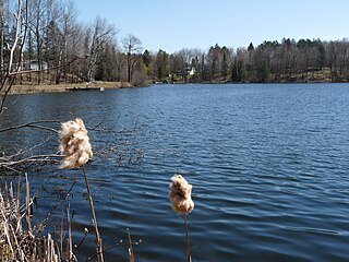
Chelsea is a town in Taylor County, Wisconsin, United States. The population was 113 at the 2010 census. The census-designated places of Chelsea and Whittlesey are located in the town.
See Cleveland (disambiguation)
Ford is a town in Taylor County, Wisconsin, United States. The population was 276 at the 2000 census. The unincorporated community of Polley is located in the town.
Goodrich is a town in Taylor County, Wisconsin, United States. The population was 510 at the 2010 census.
Greenwood is a town in Taylor County, Wisconsin, United States. The population was 642 at the 2000 census. The unincorporated community of Interwald is located in the town.
Grover is a town in Taylor County, Wisconsin, in the United States. As of the 2010 census, the town population was 256. The unincorporated community of Perkinstown is located in the town.
Hammel is a town in Taylor County, Wisconsin, United States. The population was 735 at the 2000 census. The unincorporated community of Murat is located in the town.
Little Black is a town located in Taylor County, Wisconsin. The village of Stetsonville lies partly in the town, and the hamlet of Little Black. As of the 2000 census, the town had a total population of 1,148.
McKinley is a town in Taylor County, Wisconsin, United States. The population was 418 at the 2000 census. The census-designated place of Jump River is located partially in the town.
Molitor is a town in Taylor County, Wisconsin, United States. The population was 324 at the 2010 census.
Roosevelt is a town in Taylor County, Wisconsin, United States. The population was 444 at the 2000 census. The village of Lublin lies within the town of Roosevelt. The unincorporated community of Bellinger is also located partially in the town.
Westboro is a town in Taylor County, Wisconsin, United States. The population was 660 at the 2000 census. The census-designated place of Westboro is located in the town. The unincorporated community of Queenstown is also located in the town.
Medford is a town in Taylor County, Wisconsin, United States. The population was 2,216 at the 2000 census. The City of Medford lies mostly within the town boundaries.
Rib Lake is a town in Taylor County, Wisconsin, United States. The population was 768 at the 2000 census. The village of Rib Lake is completely surrounded by the town.
Perkinstown is an unincorporated community located in the town of Grover, Taylor County, Wisconsin, United States. The hamlet is scattered around Lake Kathryn, surrounded by Chequamegon National Forest, 10 miles (16 km) east-northeast of Gilman, reached by County Highway M and several gravel roads.
Chelsea is an unincorporated census-designated place located in the town of Chelsea, Taylor County, Wisconsin, United States. Chelsea is 5 miles (8.0 km) west-southwest of Rib Lake. As of the 2010 census, its population was 113.
Whittlesey is a census-designated place in the town of Chelsea, Taylor County, Wisconsin, United States. Its population was 105 as of the 2010 census.
The Mondeaux Dam Recreation Area is a public park in the forest in the town of Westboro, Wisconsin, United States. The Civilian Conservation Corps (CCC) and Work Projects Administration (WPA) created the lake and facilities during the Great Depression.
↑ Schmirler, A. A. A., "Wisconsin's Lost Missionary: The Mystery of Father Rene Menard", The Wisconsin Magazine of History, Volume 45, number 2, winter, 1961-1962.
↑ "Field Notes for T30N R1W". Original Field Notes and Plat Maps, 1833-1866. Board of Commissioners of Public Lands. Retrieved May 31, 2011.
↑ Ruesch, Gordon (2011). Stephen Lars Kalmon (ed.). Our Home - Taylor County Wisconsin - A Topical History of our Roots. Taylor County History Project.
↑ Martin, Roy L. (January 1941). History of the Wisconsin Central (Bulletin No. 54). Boston, Mass.: The Railroad and Locomotive Historical Society, Inc., Baker Library, Harvard Business School. pp.6, 18–21, 29, 42.
↑ Nagel, Paul; (1979) S. M. & P. RY. The Stanley, Merrill and Phillips Railway
1 2 Boelter, Joseph M.; Stacy S. Eichner; Angela M. Elg; William D. Fiala; Richard M. Johannes (July 2005). "Soil Survey of Taylor County, Wisconsin"(PDF). U.S. Department of Agriculture, Natural Resources Conservation Service, and Forest Service. Archived from the original(PDF) on July 18, 2011. Retrieved April 15, 2011.
↑ Zenner, John (January 2012). "The John Zenner Story". In Kalmon, Lars (ed.). Our Home - Taylor County Wisconsin - Vol 1. Taylor County History Project. pp.12–13, 15.
↑ Bruhy, Mark E. (July 9, 1984). "Mondeaux Dam Public Utility Area". NRHP Inventory-Nomination Form. US Dept. of the Interior. National Park Service. Retrieved November 23, 2023.
↑ Reported Induced Abortions in Wisconsin, Office of Health Informatics, Division of Public Health, Wisconsin Department of Health Services. Section: Trend Information, 2013-2017, Table 18, pages 17-18
↑ "Rustic Road 1". Rustic Roads. Wisconsin Department of Transportation. Archived from the original on October 6, 2014. Retrieved October 2, 2014.
This page is based on this Wikipedia article Text is available under the CC BY-SA 4.0 license; additional terms may apply. Images, videos and audio are available under their respective licenses.