Waushara County, Wisconsin

Last updated

Waushara County
Waushara County Courthouse.jpg
Map of Wisconsin highlighting Waushara County.svg
Location within the U.S. state of Wisconsin
Wisconsin in United States.svg
Wisconsin's location within the U.S.
Coordinates: 44°07′N89°14′W / 44.11°N 89.24°W / 44.11; -89.24
CountryFlag of the United States.svg United States
StateFlag of Wisconsin.svg  Wisconsin
Founded1852
Named for Ho-Chunk term meaning "good earth"
Seat Wautoma
Largest city Berlin
Area
  Total637 sq mi (1,650 km2)
  Land626 sq mi (1,620 km2)
  Water11 sq mi (30 km2)  1.8%
Population
 (2020) [1]
  Total24,520
  Density39.2/sq mi (15.1/km2)
Time zone UTC−6 (Central)
  Summer (DST) UTC−5 (CDT)
Congressional district 6th
Website www.co.waushara.wi.us

Waushara County is a county located in the U.S. state of Wisconsin. As of the 2020 census, the population was 24,520. [1] Its county seat is Wautoma. [2]

Contents

Waushara County is located in central Wisconsin, about 80 miles (130 km) north of Madison.

History

Waushara County was established by an act of the Wisconsin Legislature on February 15, 1851. It originally consisted of a single organized Town of Waushara. In 1852 the county achieved full organization. [3] The county seat was first located at Sacramento and was relocated to Wautoma in 1854 after a bitter fight between proponents of the two places. The name is of Ho-Chunk origin and is believed to mean "good land". [4] [5]

Geography

According to the U.S. Census Bureau, the county has a total area of 637 square miles (1,650 km2), of which 626 square miles (1,620 km2) is land and 11 square miles (28 km2) (1.8%) is water. [6]

Major highways

Buses

Airports

Adjacent counties

Climate

Waushara County
Climate chart (explanation)
J
F
M
A
M
J
J
A
S
O
N
D
 
 
48
 
 
−8
−13
 
 
57
 
 
−6
−13
 
 
70
 
 
2
−6
 
 
132
 
 
18
1
 
 
131
 
 
22
8
 
 
133
 
 
26
14
 
 
64
 
 
26
18
 
 
116
 
 
24
16
 
 
73
 
 
22
12
 
 
116
 
 
15
5
 
 
54
 
 
5
−1
 
 
46
 
 
−7
−11
Average max. and min. temperatures in °C
Precipitation totals in mm
Source: [7]
Imperial conversion
JFMAMJJASOND
 
 
1.9
 
 
18
9
 
 
2.2
 
 
21
9
 
 
2.8
 
 
36
21
 
 
5.2
 
 
64
34
 
 
5.2
 
 
72
46
 
 
5.2
 
 
79
57
 
 
2.5
 
 
79
64
 
 
4.6
 
 
75
61
 
 
2.9
 
 
72
54
 
 
4.6
 
 
59
41
 
 
2.1
 
 
41
30
 
 
1.8
 
 
19
12
Average max. and min. temperatures in °F
Precipitation totals in inches

Demographics

Historical population
CensusPop.Note
1860 8,770
1870 11,27928.6%
1880 12,68712.5%
1890 13,5076.5%
1900 15,97218.2%
1910 18,88618.2%
1920 16,712−11.5%
1930 14,427−13.7%
1940 14,268−1.1%
1950 13,920−2.4%
1960 13,497−3.0%
1970 14,7959.6%
1980 18,52625.2%
1990 19,3854.6%
2000 23,15419.4%
2010 24,4965.8%
2020 24,5200.1%
U.S. Decennial Census [8]
1790–1960 [9] 1900–1990 [10]
1990–2000 [11] 2010 [12] 2020 [1]

2020 census

As of the census of 2020, [1] the population was 24,520. The population density was 39.2 people per square mile (15.1 people/km2). There were 14,710 housing units at an average density of 23.5 units per square mile (9.1 units/km2). The racial makeup of the county was 89.9% White, 1.6% Black or African American, 0.6% Native American, 0.4% Asian, 0.1% Pacific Islander, 2.8% from other races, and 4.6% from two or more races. Ethnically, the population was 6.9% Hispanic or Latino of any race.

2000 census

2000 Census Age Pyramid for Waushara County USA Waushara County, Wisconsin age pyramid.svg
2000 Census Age Pyramid for Waushara County

As of the census [13] of 2000, there were 23,154 people, 9,336 households, and 6,581 families residing in the county. The population density was 37 people per square mile (14 people/km2). There were 13,667 housing units at an average density of 22 units per square mile (8.5 units/km2). The racial makeup of the county was 96.80% White, 0.27% Black or African American, 0.31% Native American, 0.35% Asian, 0.03% Pacific Islander, 1.36% from other races, and 0.89% from two or more races. 3.66% of the population were Hispanic or Latino of any race. 47.5% were of German, 9.1% Polish, 5.9% Irish, 5.7% American and 5.6% English ancestry. 94.5% spoke English, 3.4% Spanish and 1.4% German as their first language.

There were 9,336 households, out of which 27.60% had children under the age of 18 living with them, 60.00% were married couples living together, 6.70% had a female householder with no husband present, and 29.50% were non-families. 24.90% of all households were made up of individuals, and 11.90% had someone living alone who was 65 years of age or older. The average household size was 2.43 and the average family size was 2.89.

In the county, the population was spread out, with 23.50% under the age of 18, 6.00% from 18 to 24, 24.90% from 25 to 44, 26.30% from 45 to 64, and 19.20% who were 65 years of age or older. The median age was 42 years. For every 100 females there were 101.60 males. For every 100 females age 18 and over, there were 98.80 males.

In 2017, there were 222 births, giving a general fertility rate of 67.3 births per 1000 women aged 15–44, the 22nd highest rate out of all 72 Wisconsin counties. Of these, 19 of the births occurred at home. [14] Additionally, there were 10 reported induced abortions performed on women of Waushara County residence in 2017. [15]

Communities

Waushara County Historical Museum Waushara County Wisconsin Historical Museum.jpg
Waushara County Historical Museum

Cities

Villages

Towns

Census-designated places

Unincorporated communities

Ghost towns

Politics

Waushara County has long been one of the most Republican counties in Wisconsin. Only three Democrats have carried the county at a presidential level since the formation of the Republican Party – Franklin D. Roosevelt in 1932, Bill Clinton in 1996, and Barack Obama in 2008 – of whom only Roosevelt won an absolute majority. In 1936, when Roosevelt carried Wisconsin by a two-to-one majority, Alf Landon won Waushara County by double digits, while it was one of only three Wisconsin counties, alongside Walworth and Waupaca, to vote for Barry Goldwater over Lyndon Johnson in 1964. It has voted Republican since 2012.

In other statewide races, the county is equally Republican. Waushara County has never backed a Democrat for Governor since before 1900. [16] Senators Herb Kohl in 2006 and William Proxmire in 1976 and 1970 did carry Waushara County when they swept every county in the state, but no other Democratic senatorial candidate has won the county since the Seventeenth Amendment.

United States presidential election results for Waushara County, Wisconsin [17]
Year Republican Democratic Third party
No.%No.%No.%
2020 9,01666.45%4,38832.34%1641.21%
2016 7,66763.50%3,79131.40%6165.10%
2012 6,56254.47%5,33544.28%1511.25%
2008 5,77048.70%5,86849.52%2111.78%
2004 6,88856.25%5,25742.93%1010.82%
2000 5,57154.36%4,23941.36%4384.27%
1996 3,57340.46%3,82443.31%1,43316.23%
1992 4,04539.16%3,40232.94%2,88227.90%
1988 4,95357.91%3,53541.33%650.76%
1984 5,76966.79%2,78232.21%861.00%
1980 5,57661.43%2,98732.91%5145.66%
1976 4,44954.94%3,48543.04%1642.03%
1972 4,46666.27%2,09431.07%1792.66%
1968 4,18765.35%1,65225.78%5688.87%
1964 3,43753.36%3,00446.64%00.00%
1960 4,90672.16%1,88827.77%50.07%
1956 4,71776.99%1,38722.64%230.38%
1952 5,44781.14%1,24218.50%240.36%
1948 3,59469.60%1,43027.69%1402.71%
1944 4,67575.54%1,48523.99%290.47%
1940 4,87272.88%1,74726.13%660.99%
1936 3,30251.43%2,63641.05%4837.52%
1932 2,54144.28%3,07353.56%1242.16%
1928 4,06875.42%1,26023.36%661.22%
1924 1,60235.43%2495.51%2,67159.07%
1920 4,17685.17%4829.83%2455.00%
1916 2,34567.31%1,01529.13%1243.56%
1912 1,34344.43%77225.54%90830.04%
1908 2,82079.73%50714.33%2105.94%
1904 3,14087.34%3259.04%1303.62%
1900 2,99082.03%52514.40%1303.57%
1896 3,21084.36%45611.98%1393.65%
1892 2,09168.47%78625.74%1775.80%

See also

Related Research Articles

<span class="mw-page-title-main">Winnebago County, Wisconsin</span> County in Wisconsin, United States

Winnebago County is a county in the U.S. state of Wisconsin. As of the 2020 census, the population was 171,730. Its county seat is Oshkosh. It was named for the historic Winnebago people, a federally recognized Native American tribe now known as the Ho-Chunk Nation. Chief Oshkosh was a Menominee leader in the area. Winnebago County comprises the Oshkosh-Neenah, WI Metropolitan Statistical Area, which is included in the Appleton-Oshkosh-Neenah, WI Combined Statistical Area.

<span class="mw-page-title-main">Waupaca County, Wisconsin</span> County in Wisconsin, United States

Waupaca County is a county in the U.S. state of Wisconsin. As of the 2020 census, the population was 51,812. The county seat is Waupaca. The county was created in 1851 and organized in 1853. It is named after the Waupaca River, a Menominee language name meaning 'white sand bottom', 'pale water', or 'tomorrow river'.

<span class="mw-page-title-main">Washburn County, Wisconsin</span> County in Wisconsin, United States

Washburn County is a county in the U.S. state of Wisconsin. It is named after Governor Cadwallader C. Washburn. As of the 2020 census, the population was 16,623. Its county seat is Shell Lake. The county was created in 1883.

<span class="mw-page-title-main">Vilas County, Wisconsin</span> County in Wisconsin, United States

Vilas County is a county in the state of Wisconsin, United States. As of the 2020 census, the population was 23,047. Its county seat is Eagle River. The county partly overlaps the reservation of the Lac du Flambeau Band of Lake Superior Chippewa.

<span class="mw-page-title-main">Rock County, Wisconsin</span> County in Wisconsin, United States

Rock County is a county in the U.S. state of Wisconsin. As of the 2020 census, the population was 163,687. Its county seat is Janesville. Rock County comprises the Janesville-Beloit, WI Metropolitan Statistical Area and is included in the Madison-Janesville-Beloit, WI Combined Statistical Area.

<span class="mw-page-title-main">Portage County, Wisconsin</span> County in Wisconsin, United States

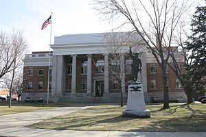
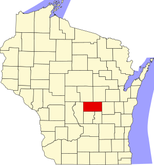
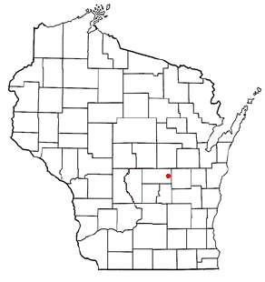
Portage County is a county in the U.S. state of Wisconsin. As of the 2020 census, the population was 70,377. Its county seat is Stevens Point.

<span class="mw-page-title-main">Outagamie County, Wisconsin</span> County in Wisconsin

Outagamie County is a county in the Fox Cities region of the U.S. state of Wisconsin, located in the northeast of the state. As of the 2020 Census, the population was 190,705. Its county seat is Appleton.

<span class="mw-page-title-main">Oneida County, Wisconsin</span> County in Wisconsin, United States

Oneida County is a county in the state of Wisconsin, United States. At the 2020 census, the population was 37,845. Its county seat is Rhinelander.

<span class="mw-page-title-main">Marquette County, Wisconsin</span> County in Wisconsin, United States

Marquette County is a county located in the U.S. state of Wisconsin. As of the 2020 census, the population was 15,592. Its county seat is Montello. The county was created in 1836 from the Wisconsin Territory and organized in 1848.

<span class="mw-page-title-main">Marinette County, Wisconsin</span> County in Wisconsin, United States

Marinette County is a county in the U.S. state of Wisconsin. As of the 2020 census, the population was 41,872. Its county seat is Marinette. Marinette County is part of the Marinette, WI–MI Micropolitan Statistical Area.

<span class="mw-page-title-main">Marathon County, Wisconsin</span> County in Wisconsin, United States

Marathon County is a county located in the U.S. state of Wisconsin. As of the 2020 census, the population was 138,013. Marathon County's seat is Wausau. It was founded in 1850, created from a portion of Portage County. At that time the county stretched to the northern border with the upper Michigan peninsula. It is named after the battlefield at Marathon, Greece.

<span class="mw-page-title-main">Lincoln County, Wisconsin</span> County in Wisconsin, United States

Lincoln County is a county located in the U.S. state of Wisconsin. As of the 2020 census, the population was 28,415. Its county seat is Merrill. The county was created in 1875 and named after President Abraham Lincoln.

<span class="mw-page-title-main">Lafayette County, Wisconsin</span> County in Wisconsin, United States

Lafayette County, sometimes spelled La Fayette County, is a county located in the U.S. state of Wisconsin. It was part of the Wisconsin Territory at the time of its founding. As of the 2020 census, the population was 16,611. Its county seat is Darlington. The county was named in honor of the Marquis de Lafayette, the French general who rendered assistance to the Continental Army in the American Revolutionary War. The courthouse scenes from the 2009 film Public Enemies were filmed at the Lafayette County Courthouse in Darlington.

<span class="mw-page-title-main">Jackson County, Wisconsin</span> County in Wisconsin, United States

Jackson County is a county located in the U.S. state of Wisconsin. As of the 2020 census, the population was 21,145. Its county seat is Black River Falls. Jackson County was formed from Crawford County in 1853. It was named for President Andrew Jackson.

<span class="mw-page-title-main">Green Lake County, Wisconsin</span> County in Wisconsin, United States

Green Lake County is a county located in the U.S. state of Wisconsin. As of the 2020 census, the population was 19,018. Its county seat is Green Lake. In 2020, the center of population of Wisconsin was located in Green Lake County, near the city of Markesan.

<span class="mw-page-title-main">Dodge County, Wisconsin</span> County in Wisconsin, United States

Dodge County is a county located in the U.S. state of Wisconsin. As of the 2020 census, the population was 89,396. Its county seat is Juneau. The county was created from the Wisconsin Territory in 1836 and organized in 1844.

<span class="mw-page-title-main">Burnett County, Wisconsin</span> County in Wisconsin, United States

Burnett County is a county located in the U.S. state of Wisconsin. As of the 2020 census, the population was 16,526. Its county seat is Siren, with the majority of county governmental services located at the Burnett County Government Center. The county was created in 1856 and organized in 1865. The St. Croix Chippewa Indians of Wisconsin have reservation lands in Burnett County and are the county's largest employer.

<span class="mw-page-title-main">Barron County, Wisconsin</span> County in Wisconsin, United States

Barron County is a county located in the U.S. state of Wisconsin. As of the 2020 census, the population was 46,711. Its county seat is Barron. The county was created in 1859 and later organized in 1874.

<span class="mw-page-title-main">Poy Sippi, Wisconsin</span> Town in Wisconsin, United States

Poy Sippi is a town in Waushara County, Wisconsin, United States. The population was 972 at the 2000 census. The census-designated place of Poy Sippi is located in the town. The unincorporated communities of Borth and Fountain Valley are also located in the town.

<span class="mw-page-title-main">Wautoma, Wisconsin</span> City in Wisconsin, United States

Wautoma is a city in Waushara County, Wisconsin, United States. The population was 2,218 at the 2010 census. Wautoma is the county seat of Waushara County.

References

  1. 1 2 3 4 "2020 Decennial Census: Waushara County, Wisconsin". data.census.gov. U.S. Census Bureau. Retrieved July 9, 2022.
  2. "Find a County". National Association of Counties. Retrieved June 7, 2011.
  3. "Wisconsin: Individual County Chronologies". Wisconsin Atlas of Historical County Boundaries. The Newberry Library. 2007. Archived from the original on April 14, 2017. Retrieved August 15, 2015.
  4. "Winnebago Took Its Name from an Indian Tribe". Appleton Post-Crescent. December 28, 1963. p. 14. Retrieved August 25, 2014 via Newspapers.com. Open Access logo PLoS transparent.svg
  5. Gard, Robert E. (September 9, 2015). The Romance of Wisconsin Place Names. Wisconsin Historical Society. ISBN   9780870207082 via Google Books.
  6. "2010 Census Gazetteer Files". United States Census Bureau. August 22, 2012. Retrieved August 9, 2015.
  7. "NASA Earth Observations Data Set Index". NASA. Retrieved January 30, 2016.
  8. "U.S. Decennial Census". United States Census Bureau. Retrieved August 9, 2015.
  9. "Historical Census Browser". University of Virginia Library. Retrieved August 9, 2015.
  10. Forstall, Richard L., ed. (March 27, 1995). "Population of Counties by Decennial Census: 1900 to 1990". United States Census Bureau. Retrieved August 9, 2015.
  11. "Census 2000 PHC-T-4. Ranking Tables for Counties: 1990 and 2000" (PDF). United States Census Bureau. April 2, 2001. Archived (PDF) from the original on October 9, 2022. Retrieved August 9, 2015.
  12. "State & County QuickFacts". United States Census Bureau. Retrieved January 24, 2014.
  13. "U.S. Census website". United States Census Bureau . Retrieved May 14, 2011.
  14. "Annual Wisconsin Birth and Infant Mortality Report, 2017 P-01161-19 (June 2019): Detailed Tables". Archived from the original on June 19, 2019. Retrieved June 23, 2019.
  15. Reported Induced Abortions in Wisconsin, Office of Health Informatics, Division of Public Health, Wisconsin Department of Health Services. Section: Trend Information, 2013-2017, Table 18, pages 17-18
  16. "Gubernatorial General Election Results Comparison – Wisconsin". Dave Leip’s U.S. Election Atlas.
  17. Leip, David. "Dave Leip's Atlas of U.S. Presidential Elections". uselectionatlas.org. Retrieved August 14, 2018.

Further reading

44°07′N89°14′W / 44.11°N 89.24°W / 44.11; -89.24