Freeman, Missouri

Last updated
Freeman, Missouri
Cass County Missouri Incorporated and Unincorporated areas Freeman Highlighted.svg
Location of Freeman, Missouri
Coordinates: 38°37′17″N94°30′21″W / 38.62139°N 94.50583°W / 38.62139; -94.50583 Coordinates: 38°37′17″N94°30′21″W / 38.62139°N 94.50583°W / 38.62139; -94.50583
Country United States
State Missouri
County Cass
Area
[1]
  Total0.88 sq mi (2.28 km2)
  Land0.86 sq mi (2.22 km2)
  Water0.02 sq mi (0.05 km2)
Elevation
[2]
915 ft (279 m)
Population
 (2020)
  Total475
  Density552.97/sq mi (213.59/km2)
Time zone UTC-6 (Central (CST))
  Summer (DST) UTC-5 (CDT)
ZIP code
64746
Area code 816
FIPS code 29-25894 [3]
GNIS feature ID2394820 [2]

Freeman is a city in Cass County, Missouri, United States. The population was 482 at the 2010 census. It is part of the Kansas City metropolitan area.

Contents

History

Freeman was platted in 1871, and named after a railroad official. [4] A post office called Freeman has been in operation since 1871. [5]

Geography

According to the United States Census Bureau, the city has a total area of 0.88 square miles (2.28 km2), of which 0.86 square miles (2.23 km2) is land and 0.02 square miles (0.05 km2) is water. [6]

Demographics

Historical population
CensusPop.Note
1880 309
1890 279−9.7%
1900 260−6.8%
1910 251−3.5%
1920 29919.1%
1930 279−6.7%
1940 3028.2%
1950 3092.3%
1960 39126.5%
1970 4176.6%
1980 48516.3%
1990 480−1.0%
2000 5218.5%
2010 482−7.5%
2020 475−1.5%
U.S. Decennial Census [7]

2010 census

As of the census [8] of 2010, there were 482 people, 178 households, and 125 families living in the city. The population density was 560.5 inhabitants per square mile (216.4/km2). There were 215 housing units at an average density of 250.0 per square mile (96.5/km2). The racial makeup of the city was 97.3% White, 0.4% African American, 0.2% Native American, 0.6% from other races, and 1.5% from two or more races. Hispanic or Latino of any race were 0.8% of the population.

There were 178 households, of which 40.4% had children under the age of 18 living with them, 50.6% were married couples living together, 13.5% had a female householder with no husband present, 6.2% had a male householder with no wife present, and 29.8% were non-families. 24.7% of all households were made up of individuals, and 8.9% had someone living alone who was 65 years of age or older. The average household size was 2.71 and the average family size was 3.18.

The median age in the city was 31.4 years. 29% of residents were under the age of 18; 10.5% were between the ages of 18 and 24; 23.1% were from 25 to 44; 26.2% were from 45 to 64; and 11% were 65 years of age or older. The gender makeup of the city was 51.2% male and 48.8% female.

2000 census

As of the census [3] of 2000, there were 521 people, 172 households, and 142 families living in the city. The population density was 1,121.2 inhabitants per square mile (432.9/km2). There were 186 housing units at an average density of 400.3 per square mile (154.6/km2). The racial makeup of the city was 97.70% White, 0.19% African American, 1.34% Native American, 0.19% Pacific Islander, and 0.58% from two or more races. Hispanic or Latino of any race were 0.77% of the population.

There were 172 households, out of which 41.3% had children under the age of 18 living with them, 64.0% were married couples living together, 15.7% had a female householder with no husband present, and 17.4% were non-families. 14.5% of all households were made up of individuals, and 7.0% had someone living alone who was 65 years of age or older. The average household size was 3.01 and the average family size was 3.30.

In the city the population was spread out, with 32.4% under the age of 18, 8.1% from 18 to 24, 32.2% from 25 to 44, 15.7% from 45 to 64, and 11.5% who were 65 years of age or older. The median age was 32 years. For every 100 females, there were 88.8 males. For every 100 females age 18 and over, there were 91.3 males.

The median income for a household in the city was $46,339, and the median income for a family was $48,500. Males had a median income of $33,750 versus $23,750 for females. The per capita income for the city was $17,450. About 5.0% of families and 9.1% of the population were below the poverty line, including 13.9% of those under age 18 and 4.6% of those age 65 or over.

Related Research Articles

<span class="mw-page-title-main">Lewis County, West Virginia</span> County in West Virginia, United States

Lewis County is a county in the U.S. state of West Virginia. As of the 2020 census, the population was 17,033. Its county seat is Weston. The county was formed in 1816 from Harrison County.

<span class="mw-page-title-main">Eagle, Idaho</span> City in Idaho, United States

Eagle is a city in the western United States in Ada County, Idaho, ten miles (16 km) northwest of downtown Boise. The population was 30,346 at the time of the 2020 census.

<span class="mw-page-title-main">Kendrick, Idaho</span> City in Idaho, United States

Kendrick is a city in Latah County, Idaho, United States. Its population was 303 at the 2010 census, a decrease from 369 in 2000.

<span class="mw-page-title-main">Woodburn, Iowa</span> City in Iowa, United States

Woodburn is a city in Clarke County, Iowa, United States. The population was 146 at the time of the 2020 census.

<span class="mw-page-title-main">Little Sioux, Iowa</span> City in Iowa, United States

Little Sioux is a city in Harrison County, Iowa, United States. The population was 166 at the time of the 2020 census. The city is most known for Little Sioux Scout Ranch of the Boy Scouts of America.

<span class="mw-page-title-main">Webster, Iowa</span> City in Iowa, United States

Webster is a city in Keokuk County, Iowa, United States. The population was 94 at the time of the 2020 census.

<span class="mw-page-title-main">Dixon, Iowa</span> City in Iowa, USA

Dixon is a city in Scott County, Iowa, United States. The population was 202 at the time of the 2020 census.

<span class="mw-page-title-main">Squaw Lake, Minnesota</span> City in Minnesota, United States

Squaw Lake is a city in Itasca County, Minnesota, United States. The population was 107 at the 2010 census.

<span class="mw-page-title-main">Kandiyohi, Minnesota</span> City in Minnesota, United States

Kandiyohi is a city in Kandiyohi County, Minnesota, United States. The population was 491 at the 2010 census.

<span class="mw-page-title-main">Bluffton, Minnesota</span> City in Minnesota, United States

Bluffton is a city in Otter Tail County, Minnesota, United States, along the Leaf River. The population was 210 at the 2020 census.

<span class="mw-page-title-main">Hoyt Lakes, Minnesota</span> City in Minnesota, United States

Hoyt Lakes is a city in Saint Louis County, Minnesota. The population was 2,017 at the time of the 2010 census.

<span class="mw-page-title-main">St. Rosa, Minnesota</span> City in Minnesota, United States

Saint Rosa is a city in Stearns County, Minnesota, United States. The population was 68 at the 2010 census. It is part of the St. Cloud Metropolitan Statistical Area.

<span class="mw-page-title-main">Pleasant Hope, Missouri</span> City in Missouri, United States

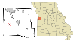
Pleasant Hope is a city in Polk County, Missouri, United States. The population was 614 at the 2010 census. It is part of the Springfield, Missouri Metropolitan Statistical Area.

<span class="mw-page-title-main">Fort Calhoun, Nebraska</span> City in Nebraska, United States

Fort Calhoun is a city in Washington County, Nebraska, United States. The population was 908 at the 2010 census. The city includes Fort Atkinson, the first fort built west of the Missouri River.

<span class="mw-page-title-main">Fifty Lakes, Minnesota</span> City in Minnesota, United States

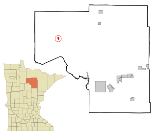
Fifty Lakes is a city in Crow Wing County, Minnesota, United States. The population was 387 at the 2010 census. It is part of the Brainerd Micropolitan Statistical Area.

<span class="mw-page-title-main">Clarkson Valley, Missouri</span> City in Missouri, United States

Clarkson Valley is a city in St. Louis County, Missouri, United States. The population was 2,609 at the 2020 census.

<span class="mw-page-title-main">North River, North Dakota</span> City in North Dakota, United States

North River is a city in Cass County, North Dakota, United States. The population was 55 at the 2020 census. North River was founded in 1973. It is a suburb/bedroom community directly adjacent to the city of Fargo.

<span class="mw-page-title-main">Sublimity, Oregon</span> City in Oregon, United States

Sublimity is a city in Marion County, Oregon, United States. The population was 2,967 at the 2020 census. It is part of the Salem Metropolitan Statistical Area.

<span class="mw-page-title-main">Freeman, South Dakota</span> City in South Dakota, United States

Freeman is a city in Hutchinson County, South Dakota, United States. The population was 1,329 at the 2020 census.

<span class="mw-page-title-main">Minneiska, Minnesota</span> City in Minnesota, United States

Minneiska is a city in Wabasha and Winona counties in the U.S. state of Minnesota. The population was 111 at the 2010 census.

References

  1. "ArcGIS REST Services Directory". United States Census Bureau. Retrieved August 28, 2022.
  2. 1 2 U.S. Geological Survey Geographic Names Information System: Freeman, Missouri
  3. 1 2 "U.S. Census website". United States Census Bureau . Retrieved 2008-01-31.
  4. "Cass County Place Names, 1928–1945 (archived)". The State Historical Society of Missouri. Archived from the original on 24 June 2016. Retrieved 17 September 2016.{{cite web}}: CS1 maint: bot: original URL status unknown (link)
  5. "Post Offices". Jim Forte Postal History. Archived from the original on 6 March 2016. Retrieved 16 September 2016.
  6. "US Gazetteer files 2010". United States Census Bureau. Archived from the original on 2012-07-02. Retrieved 2012-07-08.
  7. "Census of Population and Housing". Census.gov. Retrieved June 4, 2015.
  8. "U.S. Census website". United States Census Bureau . Retrieved 2012-07-08.