Lake Winnebago, Missouri

Last updated
Lake Winnebago, Missouri
Cass County Missouri Incorporated and Unincorporated areas Lake Winnebago Highlighted.svg
Location of Lake Winnebago, Missouri
Coordinates: 38°49′47″N94°22′42″W / 38.82972°N 94.37833°W / 38.82972; -94.37833 Coordinates: 38°49′47″N94°22′42″W / 38.82972°N 94.37833°W / 38.82972; -94.37833
Country United States
State Missouri
County Cass
Area
[1]
  Total2.73 sq mi (7.08 km2)
  Land2.32 sq mi (6.01 km2)
  Water0.41 sq mi (1.07 km2)
Elevation
[2]
951 ft (290 m)
Population
 (2020)
  Total1,433
  Density617.67/sq mi (238.52/km2)
Time zone UTC-6 (Central (CST))
  Summer (DST) UTC-5 (CDT)
FIPS code 29-40340 [3]
GNIS feature ID2395607 [2]

Lake Winnebago is a city in Cass County, Missouri, United States. The population was 1,131 at the 2010 census. It is part of the Kansas City metropolitan area.

Contents

Geography

According to the United States Census Bureau, the city has a total area of 2.72 square miles (7.04 km2), of which 2.28 square miles (5.91 km2) is land and 0.44 square miles (1.14 km2) is water. [4]

Demographics

Historical population
CensusPop.Note
1970 432
1980 68157.6%
1990 7489.8%
2000 90220.6%
2010 1,13125.4%
2020 1,43326.7%
U.S. Decennial Census [5]

2010 census

As of the census [6] of 2010, there were 1,131 people, 456 households, and 378 families living in the city. The population density was 496.1 inhabitants per square mile (191.5/km2). There were 496 housing units at an average density of 217.5 per square mile (84.0/km2). The racial makeup of the city was 97.7% White, 0.2% African American, 0.1% Native American, 0.2% Asian, 0.4% Pacific Islander, 0.5% from other races, and 1.0% from two or more races. Hispanic or Latino of any race were 1.6% of the population.

There were 456 households, of which 27.4% had children under the age of 18 living with them, 77.2% were married couples living together, 4.2% had a female householder with no husband present, 1.5% had a male householder with no wife present, and 17.1% were non-families. 14.9% of all households were made up of individuals, and 7.7% had someone living alone who was 65 years of age or older. The average household size was 2.48 and the average family size was 2.73.

The median age in the city was 50.9 years. 20.1% of residents were under the age of 18; 4.6% were between the ages of 18 and 24; 15.3% were from 25 to 44; 39.9% were from 45 to 64; and 20.2% were 65 years of age or older. The gender makeup of the city was 47.7% male and 52.3% female.

2000 census

As of the census [3] of 2000, there were 902 people, 350 households, and 289 families living in the city. The population density was 478.6 inhabitants per square mile (184.8/km2). There were 359 housing units at an average density of 190.5 per square mile (73.6/km2). The racial makeup of the city was 99.11% White, 0.11% Native American, 0.22% Asian, 0.33% from other races, and 0.22% from two or more races. Hispanic or Latino of any race were 2.33% of the population.

There were 350 households, out of which 27.7% had children under the age of 18 living with them, 77.4% were married couples living together, 2.9% had a female householder with no husband present, and 17.4% were non-families. 14.6% of all households were made up of individuals, and 6.6% had someone living alone who was 65 years of age or older. The average household size was 2.58 and the average family size was 2.84.

In the city the population was spread out, with 21.5% under the age of 18, 4.9% from 18 to 24, 22.6% from 25 to 44, 38.7% from 45 to 64, and 12.3% who were 65 years of age or older. The median age was 46 years. For every 100 females, there were 92.7 males. For every 100 females age 18 and over, there were 96.1 males.

The median income for a household in the city was $78,478, and the median income for a family was $87,150. Males had a median income of $56,500 versus $37,361 for females. The per capita income for the city was $41,891. None of the families and 1.6% of the population were living below the poverty line, including no under eighteens and none of those over 64.

Education

Much of Lake Winnebago is in Raymore-Peculiar School District, while other parts are in Lee's Summit R-VII School District. [7] The comprehensive high school of the former is Raymore-Peculiar High School.

Related Research Articles

<span class="mw-page-title-main">Loves Park, Illinois</span> City in Illinois, United States

Loves Park is a city in Boone and Winnebago counties in the U.S. state of Illinois. Most of the city is in Winnebago County, with a tiny sliver in the east located in Boone County. The population was 23,996 at the 2010 census, up from 20,044 in 2000.

<span class="mw-page-title-main">Winnebago, Illinois</span> Village in Illinois, United States

Winnebago is a village in Winnebago County, Illinois. It is part of the Rockford-Winnebago Metropolitan Statistical Area. The population was 3,101 at the 2010 census, up from 2,958 in 2000.

<span class="mw-page-title-main">Goodell, Iowa</span> City in Iowa, United States

Goodell is a city in Hancock County, Iowa, United States. The population was 140 at the time of the 2020 census.

<span class="mw-page-title-main">Lake Mills, Iowa</span> City in Iowa, United States

Lake Mills is a city in Winnebago County, Iowa, United States. The population was 2,143 at the time of the 2020 census.

<span class="mw-page-title-main">Leland, Iowa</span> City in Iowa, United States

Leland is a city in Winnebago County, Iowa, United States. The population was 249 at the time of the 2020 census.

<span class="mw-page-title-main">Sloan, Iowa</span> City in Iowa, United States

Sloan is a city in Woodbury County, Iowa, United States. It is part of the Sioux City, IA–NE–SD Metropolitan Statistical Area. The population was 1,042 at the time of the 2020 census.

<span class="mw-page-title-main">Winnebago, Minnesota</span> City in Minnesota, United States

Winnebago is a city in Faribault County, Minnesota, United States. The population was 1,391 at the 2020 census.

Winnebago City Township is a township in Faribault County, Minnesota, United States. The population was 221 at the 2000 census.

<span class="mw-page-title-main">Long Prairie, Minnesota</span> County seat and city in Minnesota, United States

Long Prairie is a town in Todd County, Minnesota, United States. The population was 3,458 at the 2010 census. It is the county seat. and the oldest town in the County.

<span class="mw-page-title-main">Belton, Missouri</span> City in Missouri, United States

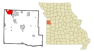
Belton is a city in northwestern Cass County, Missouri, United States. The population was 23,116 at the 2010 census.

<span class="mw-page-title-main">Peculiar, Missouri</span> City in Missouri, United States

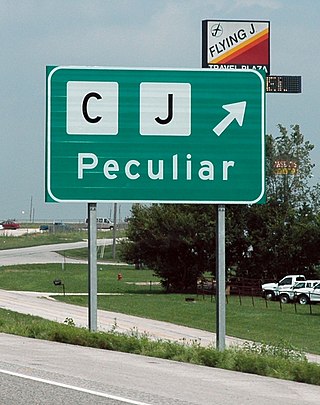
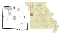
Peculiar is a city in Cass County, Missouri and is part of the Kansas City metropolitan area within the United States. The population was 4,608 at the 2010 census. The town motto is "Where the 'odds' are with you."

<span class="mw-page-title-main">Winnebago, Nebraska</span> Village in Nebraska, United States

Winnebago is a village in Thurston County, Nebraska, United States. The population was 916 at the 2020 census.

<span class="mw-page-title-main">Greenfield, Monroe County, Wisconsin</span> Town in Wisconsin, United States

Greenfield is a town in Monroe County, Wisconsin, United States. The population was 626 at the 2000 census. The unincorporated communities of Raymore, Spring Bank Park, and Tunnel City are located within the town.

<span class="mw-page-title-main">Rushford, Wisconsin</span> Town in Wisconsin, United States

Rushford is a town in Winnebago County, Wisconsin, United States. The population was 1,561 at the 2010 census. The unincorporated communities of Eureka, Island Park, and Waukau are located in the town. The ghost town of Delhi was located in the town.

<span class="mw-page-title-main">Vinland, Wisconsin</span> Town in Wisconsin, United States

Vinland is a town in Winnebago County, Wisconsin, United States. The population was 1,765 at the 2010 census. The unincorporated community of Allenville is located in the town.

<span class="mw-page-title-main">Wolf River, Winnebago County, Wisconsin</span> Town in Wisconsin, United States

Wolf River is a town in Winnebago County, Wisconsin, United States. The population was 1,189 at the 2010 census. The unincorporated communities of Orihula and Zittau are located in the town. The unincorporated community of Metz is also located partially in the town.

<span class="mw-page-title-main">Forest City, Iowa</span> City in Iowa, United States

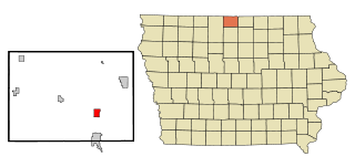
Forest City is a city in Hancock and Winnebago counties in the U.S. state of Iowa, and the county seat of Winnebago County. The population was 4,285 in the 2020 census, a decline from the 4,362 population in 2000.

<span class="mw-page-title-main">Neenah (town), Wisconsin</span> Town in Wisconsin, United States

Neenah is a town in Winnebago County, Wisconsin, United States. The population was 3,237 at the 2010 census. The City of Neenah is adjacent to the town, but is politically independent. The unincorporated communities of Adella Beach, Ricker Bay, Snells, and Sunrise Bay are located in the town.

<span class="mw-page-title-main">Omro (town), Wisconsin</span> Town in Wisconsin, United States

Omro is a town in Winnebago County, Wisconsin, United States. The population was 2,116 at the 2010 census. The City of Omro and the unincorporated communities of Harbor Springs, Reighmoor, Rivermoor, and Zion are located in the town.

<span class="mw-page-title-main">Oshkosh (town), Wisconsin</span> Town in Wisconsin, United States

Oshkosh is a town in Winnebago County, Wisconsin, United States. The population was 2,475 at the 2010 census. The City of Oshkosh is located adjacent to and partially within the town. The unincorporated communities of Nichols Shore Acres, Plummer Point, Shangri La Point, and Winnebago are located within the town.

References

  1. "ArcGIS REST Services Directory". United States Census Bureau. Retrieved August 28, 2022.
  2. 1 2 U.S. Geological Survey Geographic Names Information System: Lake Winnebago, Missouri
  3. 1 2 "U.S. Census website". United States Census Bureau . Retrieved 2008-01-31.
  4. "US Gazetteer files 2010". United States Census Bureau. Archived from the original on 2012-07-02. Retrieved 2012-07-08.
  5. "Census of Population and Housing". Census.gov. Retrieved June 4, 2015.
  6. "U.S. Census website". United States Census Bureau . Retrieved 2012-07-08.
  7. "2020 CENSUS - SCHOOL DISTRICT REFERENCE MAP: Cass County, MO" (PDF). U.S. Census Bureau . Retrieved 2022-12-09.