Peculiar, Missouri

Last updated
Peculiar, Missouri
Peculiar sign, Peculiar Missouri 7-2-2007.jpg
Sign directing travelers to Peculiar
Cass County Missouri Incorporated and Unincorporated areas Peculiar Highlighted.svg
Location of Peculiar, Missouri
Coordinates: 38°43′09″N94°27′31″W / 38.71917°N 94.45861°W / 38.71917; -94.45861 Coordinates: 38°43′09″N94°27′31″W / 38.71917°N 94.45861°W / 38.71917; -94.45861 [1]
Country United States
State Missouri
County Cass
Area
[2]
  Total9.11 sq mi (23.59 km2)
  Land9.06 sq mi (23.48 km2)
  Water0.04 sq mi (0.11 km2)
Elevation
[1]
997 ft (304 m)
Population
 (2020)
  Total5,621
  Density620.08/sq mi (239.41/km2)
Time zone UTC-6 (Central (CST))
  Summer (DST) UTC-5 (CDT)
ZIP code
64078
Area code 816
FIPS code 29-56756 [3]
GNIS feature ID2396171 [1]

Peculiar is a city in Cass County, Missouri and is part of the Kansas City metropolitan area within the United States. [4] The population was 4,608 at the 2010 census. The town motto is "Where the 'odds' are with you."

Contents

History

Early settlers of the town came to Western Missouri by riverboat from Illinois, Iowa, Michigan, Pennsylvania, and Ohio. Peculiar also had families coming from Tennessee, Kentucky, and Virginia. [5] On July 29, 1868, the county surveyor, Robert Cass, platted Peculiar and was filed as "The Town of Peculiar". [5]

There are at least two versions of the story on how Peculiar received its name. The first involves the community's first postmaster, Edgar Thomson. His first choice for a town name, "Excelsior," was rejected because it already existed in Atchison County, Missouri. Several other choices were also rejected. The story goes that the annoyed Thomson wrote to the Postmaster General himself to complain saying, among other things, "We don't care what name you give us so long as it is sort of 'peculiar'." Thomson submitted the name "Peculiar" and the name was approved. The post office was established on June 22, 1868. [6]

In an alternate version, according to Missouri folklorist Margot Ford McMillen, early settlers were searching for a location to farm. As they cleared a small rise and looked below, one remarked "Well that's peculiar! It's the very place I saw in a vision back in Connecticut." The land was purchased and eventually a village sprang up on it, which was named "Peculiar". [7]

Peculiar incorporated as a village in the 1890s and became a fourth class city of the state of Missouri in 1953. [5]

The city celebrated its centenary in July 1968. The celebrations continued for nine days and included an antique show and sale, a Lions Club championship rodeo, and an open class Western horse show. [8]

Government

Peculiar is governed by a Mayor–council government system. The mayor is elected to a two-year term. The town council, called the Board of Aldermen, is composed of six members. Two members are elected from each of the three wards in the city. One alderman is elected each year for each ward to serve a two-year term. [9]

Geography

Peculiar is located adjacent to U.S. Route 71 and the Burlington Northern Railway. Old Peculiar lies one mile to the east along the banks of the East Fork East Branch South Grand River. [10]

According to the United States Census Bureau, the city has a total area of 8.45 square miles (21.89 km2), of which 8.41 square miles (21.78 km2) is land and 0.04 square miles (0.10 km2) is water. [11]

Demographics

Historical population
CensusPop.Note
1900 104
1910 20597.1%
1920 28338.0%
1930 227−19.8%
1940 206−9.3%
1950 26729.6%
1960 45871.5%
1970 70553.9%
1980 1,571122.8%
1990 1,77713.1%
2000 2,60446.5%
2010 4,60877.0%
2020 5,62122.0%
U.S. Decennial Census [12]

2010 census

As of the census [13] of 2010, there were 4,608 people, 1,704 households, and 1,268 families living in the city. The population density was 547.9 inhabitants per square mile (211.5/km2). There were 1,816 housing units at an average density of 215.9 per square mile (83.4/km2). The racial makeup of the city was 94.9% White, 2.0% African American, 0.4% Native American, 0.3% Asian, 0.1% Pacific Islander, 0.8% from other races, and 1.5% from two or more races. Hispanic or Latino of any race were 2.7% of the population.

There were 1,704 households, of which 41.5% had children under the age of 18 living with them, 56.6% were married couples living together, 12.7% had a female householder with no husband present, 5.2% had a male householder with no wife present, and 25.6% were non-families. 21.1% of all households were made up of individuals, and 7.3% had someone living alone who was 65 years of age or older. The average household size was 2.70 and the average family size was 3.12.

The median age in the city was 32.8 years. 29.1% of residents were under the age of 18; 8.2% were between the ages of 18 and 24; 29.9% were from 25 to 44; 22.9% were from 45 to 64; and 10% were 65 years of age or older. The gender makeup of the city was 49.1% male and 50.9% female.

2000 census

As of the census [3] of 2000, there were 2,604 people, 953 households, and 730 families living in the city. The population density was 744.8 inhabitants per square mile (287.6/km2). There were 983 housing units at an average density of 281.2 per square mile (108.6/km2). The racial makeup of the city was 97.20% White, 0.27% African American, 0.42% Native American, 0.35% Asian, 0.08% Pacific Islander, 0.19% from other races, and 1.50% from two or more races. Hispanic or Latino of any race were 1.46% of the population.

There were 953 households, out of which 42.6% had children under the age of 18 living with them, 60.7% were married couples living together, 13.1% had a female householder with no husband present, and 23.3% were non-families. 19.7% of all households were made up of individuals, and 8.6% had someone living alone who was 65 years of age or older. The average household size was 2.73 and the average family size was 3.14.

In the city the population was spread out, with 31.8% under the age of 18, 9.0% from 18 to 24, 31.2% from 25 to 44, 18.7% from 45 to 64, and 9.3% who were 65 years of age or older. The median age was 31 years. For every 100 females, there were 93.9 males. For every 100 females age 18 and over, there were 89.0 males.

The median income for a household in the city was $44,769, and the median income for a family was $48,534. Males had a median income of $36,921 versus $27,885 for females. The per capita income for the city was $19,104. About 5.7% of families and 7.5% of the population were below the poverty line, including 9.4% of those under age 18 and 11.7% of those age 65 or over.

Education

Public education in Peculiar is administered by Raymore-Peculiar R-II School District. [14]

Peculiar has a public library, the Peculiar Branch library. [15]

Media

Music

In 2022, folksinger Willi Carlisle created an album titled Peculiar, Missouri; [16] referencing the town of Peculiar, with one song mentioning a local Walmart and its "hideous halogen bulbs" in the general area of the same name.

Notable people

Related Research Articles

<span class="mw-page-title-main">Cass County, Missouri</span> County in Missouri, United States

Cass County is a county located in the western part of the U.S. state of Missouri and is part of the Kansas City metropolitan area. As of the 2020 census, the population was 107,824. Its county seat is Harrisonville, however the county contains a portion of Kansas City, Missouri. The county was organized in 1835 as Van Buren County, but was renamed in 1849 after U.S. Senator Lewis Cass of Michigan, who later became a presidential candidate.

<span class="mw-page-title-main">Carlisle County, Kentucky</span> County in Kentucky, United States

Carlisle County is a county located in the U.S. state of Kentucky. As of the 2020 census, the population was 4,826, making it the fourth-least populous county in Kentucky. Its county seat is Bardwell. The county was founded in 1886 and named for John Griffin Carlisle, a Speaker of the United States House of Representatives from Kentucky. It remains a prohibition or dry county.

<span class="mw-page-title-main">Willis, Kansas</span> City in Brown County, Kansas

Willis is a city in Brown County, Kansas, United States. As of the 2020 census, the population of the city was 24.

<span class="mw-page-title-main">Savannah, Missouri</span> City in Missouri, United States

Savannah is a city and county seat of Andrew County, Missouri, United States. The population was 5,069 at the 2020 census.

<span class="mw-page-title-main">Belton, Missouri</span> City in Missouri, United States

Belton is a city in northwestern Cass County, Missouri, United States. The population was 23,116 at the 2010 census.

<span class="mw-page-title-main">Lake Winnebago, Missouri</span> City in Missouri, United States

Lake Winnebago is a city in Cass County, Missouri, United States. The population was 1,131 at the 2010 census. It is part of the Kansas City metropolitan area.

<span class="mw-page-title-main">Raymore, Missouri</span> City in Missouri, United States

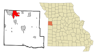
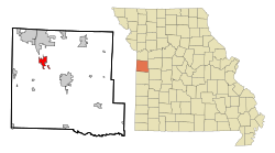
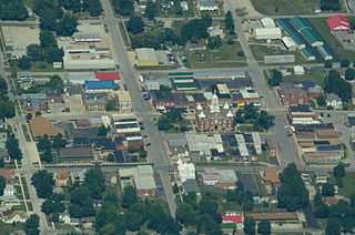
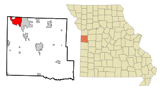
Raymore is a city in Cass County, Missouri, United States, within the Kansas City Metropolitan Area. Raymore is one of the fastest-growing cities in the state of Missouri. The population was 21,676 at the 2020 census.

<span class="mw-page-title-main">Urbana, Missouri</span> City in Missouri, United States

Urbana is a city in Dallas County, Missouri, United States. The population was 414 at the 2010 census. It is part of the Springfield, Missouri Metropolitan Statistical Area.

<span class="mw-page-title-main">Lebanon, Missouri</span> City in Missouri, United States

Lebanon is a city in and the county seat of Laclede County in Missouri. The population was 14,474 at the time of the 2010 census. It is the county seat of Laclede County. The Lebanon Micropolitan Statistical Area consists of Laclede County.

<span class="mw-page-title-main">Linneus, Missouri</span> City in Missouri, United States

Linneus is a small city in Linn County, Missouri, United States. The population was 281 at the 2020 census. It is the county seat of Linn County.

<span class="mw-page-title-main">Wheeling, Missouri</span> City in Missouri, United States

Wheeling is a city in eastern Livingston County, Missouri, United States. The population was 220 at the 2020 census.

<span class="mw-page-title-main">Altenburg, Missouri</span> City in Missouri, United States

Altenburg is a city in Perry County, Missouri, United States. The population was 341 at the 2020 census.

<span class="mw-page-title-main">Frohna, Missouri</span> Village in Missouri, United States

Frohna is a city in Perry County, Missouri, United States. The population was 245 at the 2020 census.

<span class="mw-page-title-main">Nelson, Missouri</span> City in Missouri, United States

Nelson is a city in Saline County, Missouri, United States. The population was 152 at the 2020 census.

<span class="mw-page-title-main">Bismarck, Missouri</span> City in Missouri, United States

Bismarck is a city in St. Francois County, Missouri, United States. The population was 1,546 as of the 2010 census.

<span class="mw-page-title-main">Merriam Woods, Missouri</span> City in Missouri, United States

Merriam Woods is a city in Taney County, Missouri, United States. The population was 2,006 at the 2020 census. It is part of the Branson, Missouri Micropolitan Statistical Area.

<span class="mw-page-title-main">Walker, Missouri</span> City in Missouri, United States

Walker is a city in Vernon County, Missouri, United States. The population was 199 at the 2020 census.

<span class="mw-page-title-main">Greenfield, Monroe County, Wisconsin</span> Town in Wisconsin, United States

Greenfield is a town in Monroe County, Wisconsin, United States. The population was 626 at the 2000 census. The unincorporated communities of Raymore, Spring Bank Park, and Tunnel City are located within the town.

<span class="mw-page-title-main">Carlisle, Iowa</span> City in Iowa, United States

Carlisle is a city in Warren and Polk counties in the U.S. state of Iowa. The population was 4,160 at the 2020 census. The city is part of the Des Moines–West Des Moines Metropolitan Statistical Area.

<span class="mw-page-title-main">Carlisle, Ohio</span> City in Ohio, United States

Carlisle is a city in northwestern Warren and southern Montgomery counties in the southwestern part of the U.S. state of Ohio. The city is in Franklin Township, Warren County, Ohio and German Township, Montgomery County, Ohio.

References

  1. 1 2 3 U.S. Geological Survey Geographic Names Information System: Peculiar, Missouri
  2. "ArcGIS REST Services Directory". United States Census Bureau. Retrieved August 28, 2022.
  3. 1 2 "U.S. Census website". United States Census Bureau . Retrieved 2008-01-31.
  4. "Population Data and Maps | MARC". Archived from the original on 2014-09-16. Retrieved 2019-10-17.
  5. 1 2 3 "City of Peculiar, Missouri - Official Website".
  6. 'Indecision leads to Peculiar', by Stan Durnin, Linn's Stamp News, n.d.
  7. McMillen, Margot Ford (1994). Paris, Tightwad and Peculiar: Missouri Place Names. Columbia, Missouri: University of Missouri Press. p. 6. ISBN   0-8262-0972-6.
  8. Centennial booklet, 1968
  9. History of Peculiar. Retrieved 2010-03-27.
  10. Missouri Atlas & Gazetteer, DeLorme, 1st ed. 1998, p.34 ISBN   0899332242
  11. "US Gazetteer files 2010". United States Census Bureau. Archived from the original on January 12, 2012. Retrieved 2012-07-08.
  12. "Census of Population and Housing". Census.gov. Retrieved June 4, 2015.
  13. "U.S. Census website". United States Census Bureau . Retrieved 2012-07-08.
  14. "Homepage". Raymore-Peculiar R-Ii School District. Retrieved 4 June 2019.
  15. "Missouri Public Libraries". PublicLibraries.com. Archived from the original on 10 June 2017. Retrieved 2 June 2019.
  16. Carlisle, Willi. "Willi Carlisle". Willi Carlisle. Retrieved 13 February 2023.