Geography of Greater Manchester

Last updated

Greater Manchester from Billinge Hill Manchester from Billinge Hill.jpg
Greater Manchester from Billinge Hill
Greater Manchester is heavily urbanised and consists of vast built up areas and many settlements. North Greater Manchester.jpg
Greater Manchester is heavily urbanised and consists of vast built up areas and many settlements.
A view over the borough of Tameside, towards Manchester City Centre Stalybridge towards Manchester.jpg
A view over the borough of Tameside, towards Manchester City Centre

The geography of Greater Manchester is dominated by one of the United Kingdom's largest metropolitan areas, and in this capacity the landlocked metropolitan county constitutes one of the most urbanised and densely populated areas of the country. There is a mix of high density urban areas, suburbs, semi-rural and rural locations in Greater Manchester, but overwhelmingly the land use in the county is urban. [1]

Contents

Greater Manchester is a landlocked county spanning 492.7 sq mi (1,276 km2) (39th largest in England). The Pennines rise along the eastern side of the county, through parts of the boroughs of Oldham, Rochdale and Tameside. The West Pennine Moors, as well as a number of coalfields (mainly sandstones and shales) lie in the west of the county. The rivers Mersey, Irwell and Tame run through the county boundaries, each of which rise in the Pennines. Other rivers run through the county, including the Beal, the Douglas, the Etherow, the Goyt, the Irk, the Medlock and the Roch. Black Chew Head is the highest point of Greater Manchester, rising 542 metres (1,778 ft) above sea-level, within the parish of Saddleworth. [2] Chat Moss at 10.6 square miles (27 km2) comprises the largest area of Grade 1 and 2 farmland in Greater Manchester and contains the largest block of semi-natural woodland in the county. [3] Wardle is the most northerly settlement of Greater Manchester and Ramsden Clough the most northerly point; the suburb of Woodford the most southerly settlement and New Hall Farm (by the River Dean) the most southerly point.

Greater Manchester has a strong regional central business district, formed by Manchester City Centre and the adjoining parts of Salford and Trafford. However, Greater Manchester is also a polycentric county with ten metropolitan districts, [1] each of which has a major town centre and in some cases more than one and many smaller settlements. Greater Manchester is arguably the most complex urban area in the United Kingdom outside London, [1] and this is reflected in the density of its transport network and the scale of needs for investment to meet the growing and diverse movement demands generated by its development pattern.

Settlements

The following table outlines the county's major settlements, formatted according to metropolitan borough.

Metropolitan countyMetropolitan districtCentre of administrationOther components
Greater Manchester Bury GreaterManchesterBury.png Bury Prestwich, Radcliffe, Ramsbottom, Tottington, Whitefield
Bolton GreaterManchesterBolton.png Bolton Blackrod, Farnworth, Horwich, Kearsley, Little Lever, South Turton, Westhoughton
Manchester GreaterManchesterManchester.png Manchester
(city centre)
Blackley, Burnage, Cheetham Hill, Chorlton-cum-Hardy, Didsbury, Ringway, Withington, Wythenshawe,
Oldham GreaterManchesterOldham.png Oldham Chadderton, Shaw and Crompton, Failsworth, Lees, Royton, Saddleworth
Rochdale GreaterManchesterRochdale.png Rochdale Heywood, Littleborough, Middleton, Milnrow, Newhey, Wardle
Salford GreaterManchesterSalford.png Swinton Eccles, Walkden, Worsley, Salford, Irlam, Pendlebury, Cadishead
Stockport GreaterManchesterStockport.png Stockport Bramhall, Bredbury, Cheadle, Gatley, Hazel Grove, Marple, Reddish, Romiley
Tameside GreaterManchesterTameside.png Ashton-under-Lyne Audenshaw, Denton, Droylsden, Dukinfield, Hyde, Longdendale, Mossley, Stalybridge
Trafford GreaterManchesterTrafford.png Stretford Altrincham, Bowdon, Hale, Old Trafford, Sale, Urmston
Wigan GreaterManchesterWigan.png Wigan Abram, Ashton-in-Makerfield, Aspull, Astley, Atherton, Bryn, Golborne, Higher End, Hindley, Ince-in-Makerfield, Leigh, Orrell, Standish, Shevington, Tyldesley, Winstanley

Physical and extreme points

County top

Black Chew Head is the County Top of Greater Manchester, at 542 metres (1,778 ft) above sea level. Black Chew Head Moorland - geograph.org.uk - 375773.jpg
Black Chew Head is the County Top of Greater Manchester, at 542 metres (1,778 ft) above sea level.

Extremities

The extreme points of Greater Manchester are:

Geographic midpoint

Borough tops

The following lists and ranks the highest point of each of Greater Manchester's metropolitan boroughs: [4]

Greater Manchester UK relief location map.jpg
Red triangle with thick white border.svg
Hoarstone Edge
Red triangle with thick white border.svg
Holcolmbe Moor
Red triangle with thick white border.svg
Mellor Moor
Red triangle with thick white border.svg
Greenheys
Red triangle with thick white border.svg
Greenheys
Red triangle with thick white border.svg
The Devisdale
The high points of each of Greater Manchester's metropolitan boroughs [4]
Rank Metropolitan borough Height (m)NameGrid reference
1 Oldham 542 Black Chew Head SE056019
2 Tameside 497Hoarstone Edge SE019016
3 Rochdale 474 Blackstone Edge SD971163
4 Bolton 445 Winter Hill SD662146
5 Bury 415Holcombe Moor SD755190
6 Stockport 327Mellor Moor SJ986872
7 Wigan 156 Billinge Hill SD523018
8 Salford 115 Greenheys SD713049
9 Manchester 108 Heaton Park SD834045
10 Trafford 70The Devisdale SJ757869

Geology

The underlying geology of Greater Manchester is dominated by rocks from three main periods from the geologic time scaleCarboniferous, Permian-and-Triassic, and Quaternary. [5]

Most of Manchester, and its suburban fringe to the south, is located on Permian sandstones and red Triassic sandstones and mudstones, mantled by thick deposits of till and pockets of sand and gravel deposited by glaciers at the end of the last glacial period, some 15,000 years ago. [5] The oldest rocks, from the Upper Carboniferous period, are sandstones and shales of Millstone Grit present as outcrops and uplands in the north-east of Greater Manchester, such as the upland moors of Dark Peak and South Pennines to the east and northeast of Rochdale, Oldham and Stalybridge. These rocks are overlain by shales, mudstones and thin coals of Coal Measures upon which the towns of Oldham, Rochdale, Bolton and Wigan are located. An outcrop of Coal Measures extends southwards down through Tameside and into Hazel Grove. [5]

Starting in October 2002, a relatively large number of earthquakes were recorded in Greater Manchester, some of which were among notable tremours in the British Isles. By the end of November 2002 more than 100 earthquakes had been recorded by the British Geological Survey. [5] The first quake, of magnitude 3.2 on the Richter Scale, struck on Monday 21 October 2002, with an epicentre about 1 mile (1.6 km) east of Manchester Piccadilly station at a depth of 3.4 kilometres (2.1 mi) A second quake of magnitude 3.9 on the Richter Scale followed four hours later and was followed by a further two substantial earthquakes on 22 October 2002. The epicentres were within a region of about 1 kilometre (0.62 mi) in diameter, about 2 kilometres (1.2 mi) northeast of the University of Manchester, leading to the rare classification of "Earthquake swarm" for the geological events. This earthquake swarm was probably caused by the movement of blocks of rocks at depth along faults that occur in the Upper Carboniferous and Triassic succession, underlying the area. [5]

Shallow, primitive, and small-scale coal mining from the Upper Carboniferous Coal Measures in what became Greater Manchester started as early as the 13th century. The situation changed dramatically during and after the Industrial Revolution; the construction of the Bridgewater Canal and other canals in the area, enabled coal to be cheaply transported to Manchester and the River Mersey for shipment. [5] In Oldham, relatively shallow pits were dug due to flooding problems. The writer Daniel Defoe, on a visit to Oldham, described it as a place of "... Coals ... upon the top of the highest hills" because the coal seams were so shallow and accessible. [5] Advances in mining technology during the late-19th century lead to the formation of deeper mines. The Long Depression aside, there was a rapid acceleration of coal mining until about 1920, when the collieries in the eastern part of the Manchester Coalfield were exhausted and closed. [5] In the western part of the coalfield, however, coal mining was continued into the 1960s. Coal mining ceased in north Manchester in the late 1970s. [5]

Fringe and boundary

The outer boundary of Greater Manchester, roughly 130 miles (209 km), "passes through or near several areas of natural beauty". [6] To the northwest are the West Pennine Moors, and to the north and northeast the South Pennines. Parts of the Peak District National Park also cover the east and south east of Greater Manchester.

Urban Area

An aerial photograph, centred on Manchester and Salford Greater Manchester aerial photograph.jpg
An aerial photograph, centred on Manchester and Salford

The Greater Manchester Urban Area is the larger of two main conurbations defined by the Office for National Statistics that lie within the county boundaries, the other being the Wigan Urban Area.

The Greater Manchester Urban Area is an area of land defined by the Office for National Statistics consisting of the large conurbation surrounding and including the City of Manchester. Its territory spans much, but not all of the metropolitan county of Greater Manchester. It excludes settlements such as Wigan, Westhoughton, and Marple from the Greater Manchester county boundaries (Wigan itself forming the Wigan Urban Area), but includes some settlements which are outside of the county boundaries, such as Wilmslow and Alderley Edge in Cheshire, and Whitworth in Lancashire. [7]

Climate

Greater Manchester experiences a temperate maritime climate, like most of the British Isles,[ citation needed ] with relatively cool summers and mild winters. The county's average annual rainfall is 806.6 millimetres (31.76 in) [8] compared to the UK average of 1,125.0 millimetres (44.29 in), [9] and its mean rain days are 140.4 per annum, [8] compared to the UK average of 154.4. [9] The mean temperature is slightly above average for the United Kingdom; [10] Greater Manchester also has a relatively high humidity level, which lent itself to the optimised and breakage-free textile manufacturing which took place around the county. Snowfall is not a common sight in the built up areas, due to the urban warming effect. However, the Pennine and Rossendale Forest hills around the eastern and northern edges of the county receive more snow, and roads leading out of the county can be closed due to heavy snowfall, [11] notably the A62 road via Standedge, [12] the A57 (Snake Pass) towards Sheffield, [13] and the M62 over Saddleworth Moor. [14]

MonthJanFebMarAprMayJunJulAugSepOctNovDecYear
Record high °C (°F)14.3
(57.7)
19.0
(66.2)
21.7
(71.1)
25.1
(77.2)
26.7
(80.1)
31.3
(88.3)
37.0
(98.6)
33.7
(92.7)
28.4
(83.1)
27.0
(80.6)
17.7
(63.9)
15.1
(59.2)
37.0
(98.6)
Mean daily maximum °C (°F)7.3
(45.1)
7.6
(45.7)
10.0
(50.0)
12.6
(54.7)
16.1
(61.0)
18.6
(65.5)
20.6
(69.1)
20.3
(68.5)
17.6
(63.7)
13.9
(57.0)
10.0
(50.0)
7.4
(45.3)
13.5
(56.3)
Daily mean °C (°F)4.5
(40.1)
4.6
(40.3)
6.7
(44.1)
8.8
(47.8)
11.9
(53.4)
14.6
(58.3)
16.6
(61.9)
16.4
(61.5)
14.0
(57.2)
10.7
(51.3)
7.1
(44.8)
4.6
(40.3)
10.0
(50.0)
Mean daily minimum °C (°F)1.7
(35.1)
1.6
(34.9)
3.3
(37.9)
4.9
(40.8)
7.7
(45.9)
10.5
(50.9)
12.6
(54.7)
12.4
(54.3)
10.3
(50.5)
7.4
(45.3)
4.2
(39.6)
1.8
(35.2)
6.6
(43.9)
Record low °C (°F)−15.0
(5.0)
−13.1
(8.4)
−9.7
(14.5)
−4.9
(23.2)
−1.7
(28.9)
0.8
(33.4)
5.4
(41.7)
3.6
(38.5)
0.0
(32.0)
−4.7
(23.5)
−10.0
(14.0)
−14.0
(6.8)
−15.0
(5.0)
Average precipitation mm (inches)72.3
(2.85)
51.4
(2.02)
61.2
(2.41)
54.0
(2.13)
56.8
(2.24)
66.1
(2.60)
63.9
(2.52)
77.0
(3.03)
71.5
(2.81)
92.5
(3.64)
81.5
(3.21)
80.7
(3.18)
828.8
(32.63)
Average snowfall mm (inches)24
(0.9)
19
(0.7)
10
(0.4)
1
(0.0)
0
(0)
0
(0)
0
(0)
0
(0)
0
(0)
0
(0)
2
(0.1)
15
(0.6)
71
(2.7)
Average precipitation days (≥ 1.0 mm)13.19.712.311.210.411.110.912.011.113.614.113.5142.9
Average snowy days65320000001320
Average relative humidity (%)83817774727476777981838479
Average dew point °C (°F)2
(36)
2
(36)
3
(37)
4
(39)
7
(45)
9
(48)
11
(52)
12
(54)
10
(50)
8
(46)
5
(41)
3
(37)
6
(43)
Mean monthly sunshine hours 52.573.999.0146.9188.3172.5179.7166.3131.299.359.547.11,416.2
Mean daily sunshine hours 3.43.45.26.86.76.46.66.05.93.83.53.65.1
Average ultraviolet index 0124566542103
Source 1: Met Office [15] NOAA (relative humidity and snow days 1961–1990) [16]
Source 2: KNMI [17] [18] Current Results - Weather and Science [19] Meteo Climat [20] Time and Date: Average dew point (1985-2015) [21] WeatherAtlas [22]

Flora and fauna

Common cottongrass (Eriophorum angustifolium), seen here at Light Hazzles Reservoir near Littleborough, was voted the county flower of Greater Manchester in 2002. Common cottongrass at Light Hazzles Reservoir.jpg
Common cottongrass (Eriophorum angustifolium), seen here at Light Hazzles Reservoir near Littleborough, was voted the county flower of Greater Manchester in 2002.

Contrary to its reputation as an urban sprawl, [23] [24] Greater Manchester has green belt, constraining urban drift, and a "wide and varied range" of wildlife and natural habitat. [23] For instance, the wooded valleys of Bolton, Bury and Stockport, the moorlands north and east of Rochdale, Oldham and Stalybridge, and the reed beds between Wigan and Leigh, harbour flora and fauna of national importance. [23] Mature woodland, scrubland, grassland, high moorland, mossland, agricultural land, lakes, wetlands, river valleys, embankments, urban parks and suburban gardens are habitats found in Greater Manchester which further contribute to biodiversity. [24] The Greater Manchester Ecology Unit classifies Sites of Biological Importance. [25] The 21 Sites of Special Scientific Interest (SSSI) in Greater Manchester, and the 12.1 square miles (31 km2) of common land in Greater Manchester [26] are of particular interest to organisations such as the Greater Manchester Local Record Centre, the Greater Manchester Biodiversity Project and the Manchester Field Club, which are dedicated to wildlife conservation and the preservation of the region's natural history. [27] [28] [29] Among the SSSIs are Astley and Bedford Mosses which form a network of ancient peat bog on the fringe of Chat Moss, [23] which in turn, at 10.6 square miles (27 km2) comprises the largest area of prime farmland in Greater Manchester and contains the largest block of semi-natural woodland in the county. [30] The Wigan Flashes, such as those at Pennington Flash Country Park, are the by-product of coal mining, where subsidence has led to waterbodies collecting in the resulting hollows which form an important reed bed resource in Greater Manchester. [23] Opened in 1979, Sale Water Park is a 152-acre (62 ha) area of countryside and parkland in Sale which includes a 52-acre (21 ha) artificial lake by the River Mersey. [31]

Clover, sorrel, nettle and thistle are common, and grow wild in Greater Manchester. [24] Common heather (Calluna vulgaris) dominates the uplands, such as Saddleworth Moor, which lies within the South Pennines and Dark Peak area of the Peak District National Park. [32] The Rochdale Canal harbours Floating Water-plantain (Luronium), an endangered aquatic plant. [23] In 2002, Plantlife International launched its County Flowers campaign, asking members of the public to nominate and vote for a wild flower emblem for their county. Common cottongrass (Eriophorum angustifolium), a plant with fluffy white plumes native to wet hollows on high moors, was announced as the county flower of Greater Manchester. [33] [34] [35]

The grey squirrel was the most common wild mammal seen in Greater Manchester in 2012, and were reported in four out of five gardens; hedgehogs were seen in nearly half of all gardens surveyed; bats were seen in a third of all gardens surveyed. [36] The house sparrow, common starling, and common blackbird are among the most populous bird species in Greater Manchester; [37] almost a third of Greater Manchester's gardens had baby blackbirds in June 2012. [38] Eurasian magpie and feral pigeon are common and breed in habitats across the county. [37] The South Pennines support internationally important numbers of European golden plover, curlew, merlin and twite. [26]

Related Research Articles

<span class="mw-page-title-main">Greater Manchester</span> County of England

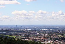
Greater Manchester is a ceremonial county in North West England. It borders Lancashire to the north, Derbyshire and West Yorkshire to the east, Cheshire to the south, and Merseyside to the west. Its largest settlement is the city of Manchester.

<span class="mw-page-title-main">Failsworth</span> Town in Greater Manchester, England

Failsworth is a town in Greater Manchester, England, 4 miles (6.4 km) north-east of Manchester and 3 miles (4.8 km) south-west of Oldham. The orbital M60 motorway skirts it to the east. The population at the 2011 census was 20,680. Historically in Lancashire, Failsworth until the 19th century was a farming township linked ecclesiastically with Manchester. Inhabitants supplemented their farming income with domestic hand-loom weaving. The humid climate and abundant labour and coal led to weaving of textiles as a Lancashire Mill Town with redbrick cotton mills. A current landmark is the Failsworth Pole. Daisy Nook is a country park on the southern edge.

<span class="mw-page-title-main">Saddleworth</span> Human settlement in England

Saddleworth is a civil parish of the Metropolitan Borough of Oldham in Greater Manchester, England. It comprises several villages and hamlets as well as suburbs of Oldham on the west side of the Pennine hills.

<span class="mw-page-title-main">Rochdale</span> Town in Greater Manchester, England

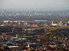
Rochdale is a town in Greater Manchester, England, and the administrative centre of the Metropolitan Borough of Rochdale. In the 2021 census the town had a population of 111,261, compared to 223,773 for the wider borough. Rochdale is in the foothills of the South Pennines and lies in the dale (valley) of the River Roch, 5 miles (8 km) northwest of Oldham, and 10 miles (16 km) northeast of Manchester.

<span class="mw-page-title-main">Metropolitan Borough of Oldham</span> Borough of Greater Manchester, England

The Metropolitan Borough of Oldham is a metropolitan borough of Greater Manchester in England. It is named after its largest town, Oldham. The borough had a population of 242,072 in 2021, making it the sixth-largest district by population in Greater Manchester. The borough spans 142.3 square kilometres (54.9 sq mi).

<span class="mw-page-title-main">Milnrow</span> Human settlement in England

Milnrow is a town within the Metropolitan Borough of Rochdale, in Greater Manchester, England. It lies on the River Beal at the foothills of the South Pennines, and forms a continuous urban area with Rochdale. It is 2 miles (3.2 km) east of Rochdale town centre, 10 miles (16.1 km) north-northeast of Manchester, and spans from Windy Hill in the east to the Rochdale Canal in the west. Milnrow is adjacent to junction 21 of the M62 motorway, and includes the village of Newhey, and hamlets at Tunshill and Ogden.

<span class="mw-page-title-main">Salford Hundred</span> United Kingdom legislation

The Salford Hundred was one of the subdivisions of the historic county of Lancashire in Northern England (see:Hundred. Its name alludes to its judicial centre being the township of Salford. It was also known as the Royal Manor of Salford and the Salford wapentake.

<span class="mw-page-title-main">Middleton, Greater Manchester</span> Town in Greater Manchester, England

Middleton is a town in the Metropolitan Borough of Rochdale, Greater Manchester, England, on the River Irk 5 miles (8.0 km) southwest of Rochdale and 5 miles (8.0 km) northeast of Manchester. Middleton had a population of 42,972 at the 2011 Census. It lies on the northern edge of Manchester, with Blackley to the south and Moston to the south east have it large.

<span class="mw-page-title-main">Littleborough, Greater Manchester</span> Town in Rochdale, England

Littleborough is a town in the Metropolitan Borough of Rochdale, Greater Manchester, England, in the upper Roch Valley by the foothills of the South Pennines, 3 miles (4.8 km) northeast of Rochdale and 13 miles (20.9 km) northeast of Manchester; Milnrow and the M62 motorway are to the south, and the rural uplands of Blackstone Edge to the east. According to the 2001 census, Littleborough, and its suburbs of Calderbrook, Shore and Smithy Bridge, had a population of 13,807.

<span class="mw-page-title-main">Oldham East and Saddleworth (UK Parliament constituency)</span> Parliamentary constituency in the United Kingdom, 1997 onwards

Oldham East and Saddleworth is a constituency in outer Greater Manchester represented in the House of Commons of the UK Parliament since January 2011 by Debbie Abrahams of the Labour Party.

<span class="mw-page-title-main">Wardle, Greater Manchester</span> Human settlement in England

Wardle is a village near Littleborough within the Metropolitan Borough of Rochdale, in Greater Manchester, England. It lies amongst the foothills of the South Pennines, 1.8 miles (2.9 km) east-southeast of Whitworth, 2.5 miles (4 km) north-northwest of Rochdale and 12 miles (19 km) north-northeast of the city of Manchester.

<span class="mw-page-title-main">Greater Manchester Built-up Area</span> Conurbation in England

The Greater Manchester Built-up Area is an area of land defined by the Office for National Statistics (ONS), consisting of the large conurbation that encompasses the urban element of the city of Manchester and the metropolitan area that forms much of Greater Manchester in North West England. According to the United Kingdom Census 2011, the Greater Manchester Built-up Area has a population of 2,553,379 making it the second most populous conurbation in the United Kingdom after the Greater London Built-up Area. This was an increase of 14% from the population recorded at the United Kingdom Census 2001 of 2,240,230, when it was known as the Greater Manchester Urban Area.

<span class="mw-page-title-main">Shaw and Crompton</span> Civil parish in Greater Manchester, England

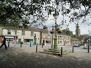
Shaw and Crompton is a civil parish in the Metropolitan Borough of Oldham, Greater Manchester, England, and lies on the River Beal at the foothills of the South Pennines. It is located 2.3 miles (3.7 km) north of Oldham, 3.6 miles (5.8 km) south-east of Rochdale and 8.7 miles (14 km) north-east of Manchester. Its largest settlement is Shaw.

<span class="mw-page-title-main">South Pennines</span> Region of moorland and hills in northern England

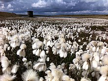
The South Pennines is a region of moorland and hill country in northern England lying towards the southern end of the Pennines. In the west it includes the Rossendale Valley and the West Pennine Moors. It is bounded by the Greater Manchester conurbation in the west and the Bowland Fells and Yorkshire Dales to the north. To the east it is fringed by the towns of West Yorkshire whilst to the south it is bounded by the Peak District. The rural South Pennine Moors constitutes both a Site of Special Scientific Interest and Special Area of Conservation.

<span class="mw-page-title-main">Demographics of Greater Manchester</span>

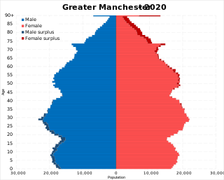
The demography of Greater Manchester is analysed by the Office for National Statistics and data is produced for each of its ten metropolitan boroughs, each of the Greater Manchester electoral wards, the NUTS3 statistical sub-regions, each of the Parliamentary constituencies in Greater Manchester, the 15 civil parishes in Greater Manchester, and for all of Greater Manchester as a whole; the latter of which had a population of 2,682,500 at the 2011 UK census. Additionally, data is produced for the Greater Manchester Urban Area. Statistical information is produced about the size and geographical breakdown of the population, the number of people entering and leaving country and the number of people in each demographic subgroup.

<span class="mw-page-title-main">Sholver</span> Human settlement in England

Sholver is an area of Oldham, in Greater Manchester, England. An elevated, residential area, it lies near the middle of the Oldham part of the valley of the River Beal, 2.1 miles (3.4 km) northeast of Oldham's commercial centre, nearly at the northeasternmost extremity of the town, by open countryside close to the source of the River Medlock and by the border with Saddleworth.

<span class="mw-page-title-main">Dobcross</span> Human settlement in England

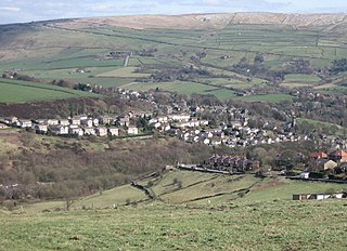
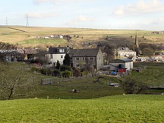
Dobcross is a village in the civil parish of Saddleworth in the Metropolitan Borough of Oldham in Greater Manchester, England. It is in a valley in the South Pennines, along the course of the River Tame and the Huddersfield Narrow Canal, 4.2 miles (6.8 km) east-northeast of Oldham and 13 miles (21 km) west-southwest of Huddersfield.

<span class="mw-page-title-main">Denshaw</span> Village in Saddleworth, Greater Manchester

Denshaw is a village in the civil parish of Saddleworth in the Metropolitan Borough of Oldham, in Greater Manchester, England. It lies by the source of the River Tame, high amongst the Pennines above the village of Delph, 4.6 miles (7.4 km) northeast of Oldham,3.3 miles (5.3 km) north-northwest of Uppermill and Shaw and Crompton. It has a population of around 500.

References

Notes

  1. 1 2 3 Greater Manchester Passenger Transport Authority. "The Greater Manchester Area and its Regional Context". gmltp.co.uk. Archived from the original on 27 September 2007. Retrieved 11 April 2007.
  2. Dawson, A., (1992), The Relative Hills of Britain - Chapter 6: The County Tops, Cicerone Press, Milnthorpe, Cumbria.
  3. Salford City Council (2007). "Chat Moss". salford.gov.uk. Archived from the original (http) on 28 September 2008. Retrieved 13 November 2007.
  4. 1 2 Muir 2011, pp. 201–204.
  5. 1 2 3 4 5 6 7 8 9 Natural England. "Greater Manchester (including: Wigan, Bolton, Salford, Trafford, Bury, Rochdale, Stockport, Manchester, Tameside and Oldham)". naturalengland.org.uk. Archived from the original on 27 March 2012. Retrieved 28 September 2012.
  6. Phythian 1992 , p. 4.
  7. KS01 Usual resident population Census 2001, Key Statistics for urban areas Office for National Statistics.
  8. 1 2 "Manchester Airport 1971–2000 weather averages". Met Office. 2001. Archived from the original on 29 September 2007. Retrieved 15 July 2007.
  9. 1 2 "UK 1971–2000 averages". Met Office. 2001. Archived from the original on 5 July 2009. Retrieved 15 July 2007.
  10. Met Office (2007). "Annual UK weather averages". Met Office. Archived from the original on 5 July 2009. Retrieved 23 April 2007.
  11. "Roads chaos as snow sweeps in Manchester". Manchester Evening News. 2005. Retrieved 15 July 2007.
  12. "Snow: West Yorkshire traffic and travel latest". Halifax Courier. Retrieved 10 November 2017.
  13. "Peak District sightseer's guide – Snake Pass". High Peak. 2002. Retrieved 6 July 2007.
  14. "Live: M62 motorway closed and 20 miles of queues as snow and high winds return to Greater Manchester". Manchester Evening News. 4 April 2012. Retrieved 10 November 2017.
  15. "Manchester 1981-2010 Averages". Met Office. Retrieved 30 January 2016.
  16. "Manchester Ringway weather station 1961-1990" (FTP). NOAA . Retrieved 4 August 2023.
  17. "Manchester ringway extreme values". KNMI . Retrieved 30 January 2016.
  18. "Manchester ringway 1981-2010 mean extreme values". KNMI . Retrieved 2 January 2018.
  19. "Average snowfall over the UK" . Retrieved 3 June 2019.
  20. "STATION MANCHESTER". Meteo climat. Retrieved 2 January 2021.
  21. "Climate & Weather Averages in Manchester, England, United Kingdom". Time and Date. Retrieved 9 January 2022.
  22. "Monthly weather forecast and Climate – Manchester, United Kingdom". Weather Atlas. Retrieved 9 January 2022.
  23. 1 2 3 4 5 6 Greater Manchester Biodiversity Project. "Greater Manchester Biodiversity". gmbp.org.uk. Retrieved 7 September 2012.
  24. 1 2 3 Hardy (1998), p. 7.
  25. Manchester City Council. "Sites of Biological Importance". wildaboutmanchester.info. Retrieved 7 September 2012.
  26. 1 2 Defra (2002). Aitchison, J.W. (ed.). "The Commonlands of Greater Manchester: A Biological Survey" (PDF). defra.gov.uk. Archived from the original (PDF) on 31 October 2012. Retrieved 7 September 2012.
  27. Greater Manchester Local Record Centre. "Welcome to Greater Manchester LRC". gmwildlife.org.uk. Retrieved 7 September 2012.
  28. Greater Manchester Bidiversity Project. "What is biodiversity?". gmbp.org.uk. Retrieved 7 September 2012.
  29. "Welcome to the Manchester Field Club". webspace.mypostoffice.co.uk. Archived from the original on 25 June 2013. Retrieved 7 September 2012.
  30. Salford City Council (2007). "Chat Moss". salford.gov.uk. Archived from the original on 28 September 2008. Retrieved on 13 November 2007.
    "Agricultural Land Classification" (PDF). Department for Environment, Food and Rural Affairs. July 2003. Archived from the original (PDF) on 25 February 2009. Retrieved on 12 July 2008.
  31. "Appendix J River Mersey Case Study Report". The Countryside Agency. Archived from the original (DOC) on 27 September 2007. Retrieved 27 April 2007.
  32. "South Pennine Moors". Defra. Retrieved 21 July 2012.
  33. Lashley, Brian (20 March 2003). "So what bloom best suits you?". Manchester Evening News . menmedia.co.uk. Archived from the original on 21 April 2013. Retrieved 7 September 2012.
  34. Devon Wildlife Trust. "Species - Cottongrass, common". devonwildlifetrust.org. Archived from the original on 26 June 2015. Retrieved 7 September 2012.
  35. Plantlife International. "North-west England". plantlife.org.uk. Archived from the original on 1 May 2013. Retrieved 7 September 2012.
  36. RSPB (15 August 2012). "Winners and losers of wet spring revealed". rspb.org.uk. Retrieved 30 September 2012.
  37. 1 2 Holland, Spence & Sutton (1984), pp. 28–29.
  38. RSPB (22 May 2012). "Make your Nature Count arrives in Greater Manchester". rspb.org.uk. Retrieved 30 September 2012.

Bibliography