River Irk

Last updated

River Irk
River Irk, Crumpsall, Manchester - geograph.org.uk - 1784.jpg
The Irk at Crumpsall
Greater Manchester UK relief location map.jpg
Red pog.svg
Location of the mouth within Greater Manchester
Location
Country England
Physical characteristics
Source 
  location Royton
Mouth  
  location
River Irwell
  coordinates
53°29′12.93″N2°14′42.13″W / 53.4869250°N 2.2450361°W / 53.4869250; -2.2450361 Coordinates: 53°29′12.93″N2°14′42.13″W / 53.4869250°N 2.2450361°W / 53.4869250; -2.2450361

The River Irk is a river in the historic county of Lancashire in the North West England that flows through the northern most Lancastrian towns of the ceremonial county of Greater Manchester.

Contents

It rises to the east of Royton and runs west past Chadderton, Middleton and Blackley before merging with the River Irwell in the centre of Manchester.

History

The Irk's name is of obscure etymology, [1] but may be Brittonic in origin and related to the Welsh word iwrch, meaning roebuck. [2] The Afon Iwrch, a river in Denbighshire, also takes its name from this word. [2]

In medieval times, there was a mill by the Irk at which the tenants of the manor ground their corn and its fisheries were controlled by the lord of the manor. In the 16th century, throwing carrion and other offensive matter into the Irk was forbidden. Water for Manchester was drawn from the river before the Industrial Revolution. [3] A bridge over the Irk was recorded in 1381. The river was noted for destructive floods. In 1480, the burgesses of Manchester described the highway between Manchester and Collyhurst which "the water of Irk had worn out". In 1816, of seven bridges over the Irk, six were liable to be flooded after heavy rain but the seventh, the Ducie Bridge completed in 1814 was above flood levels. [4]

According to The New Gazetteer of Lancashire (1830) the Irk had "more mill seats upon it than any other stream of its length in the Kingdom" and "the eels in this river were formerly remarkable for their fatness, which was attributed to the grease and oils expressed by the mills from the woollen cloths and mixed with the waters." [5] However, by the start of the 20th century the Irk Valley between Crumpsall and Blackley had been left a neglected river, "not only the blackest but the most sluggish of all rivers".

Friedrich Engels described the banks of the Irk in Manchester at the height of the city's industrial excess. [6]

The river has since been culverted as it reaches the city centre. It disappears beneath Manchester Victoria railway station into a brick tunnel at Ducie Bridge and empties into the Irwell beneath a railway viaduct.

On 15 August 1953, the front coach of a Manchester to Bury electric train fell from the viaduct over the River Irk after colliding with a local steam train. Ten people were killed and 58 injured in what became known as the Irk Valley Junction disaster. [7]

Tributaries

River Irk source - geograph.org.uk - 84936.jpg
Irk and Irwell Confluence.JPG
The source of the Irk (left) and its confluence with the Irwell (right)

Related Research Articles

Castlefield Human settlement in England

Castlefield is an inner city conservation area of Manchester in North West England. The conservation area which bears its name is bounded by the River Irwell, Quay Street, Deansgate and Chester Road. It was the site of the Roman era fort of Mamucium or Mancunium which gave its name to Manchester. It was the terminus of the Bridgewater Canal, the world's first industrial canal, built in 1764; the oldest canal warehouse opened in 1779. The world's first passenger railway terminated here in 1830, at Liverpool Road railway station and the first railway warehouse opened here in 1831.

River Lune River in Cumbria and Lancashire, England

The River Lune is a river 53 miles (85 km) in length in Cumbria and Lancashire, England.

River Ribble River in North Yorkshire and Lancashire, England

The River Ribble runs through North Yorkshire and Lancashire in Northern England. It starts close to the Ribblehead Viaduct in North Yorkshire, and is one of the few that start in the Yorkshire Dales and flow westwards towards the Irish Sea.

River Irwell River in Lancashire, United Kingdom

The River Irwell is a tributary of the River Mersey in north west England. It rises at Irwell Springs on Deerplay Moor, approximately 1+12 miles north of Bacup and flows southwards for 39 mi (63 km) to meet the Mersey near Irlam. The Irwell marks the boundary between Manchester and Salford, and its lower reaches have been canalised and now form part of the Manchester Ship Canal.

River Medlock River in Greater Manchester, England

The River Medlock is a river in Greater Manchester, England, which rises near Oldham and flows south and west for 10 miles to join the River Irwell in Manchester city centre.

River Roch River in Greater Manchester, England

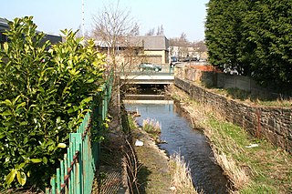
The River Roch is a river in Greater Manchester in North West England, a tributary of the River Irwell, that gives Rochdale its name.

Ramsbottom Human settlement in England

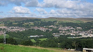
Ramsbottom is a market town in the Metropolitan Borough of Bury, Greater Manchester, England. The population at the 2011 census was 17,872.

Pendlebury Human settlement in England

Pendlebury is a town in the City of Salford, Greater Manchester, England. The population at the 2011 Census was 13,069. It lies 4.1 miles (6.6 km) northwest of Manchester city centre, 3.4 miles (5.5 km) northwest of Salford, and 5.9 miles (9.5 km) southeast of Bolton.

Rossendale Valley River valley in Lancashire, England

The Rossendale Valley is in the Rossendale area of Lancashire, England, between the West Pennine Moors and the main range of the Pennines. The area includes the steep-sided valleys of the River Irwell and its tributaries, which flow southwards into Greater Manchester. The rivers cut through the moorland of the Rossendale Hills, generally characterized by open unwooded land, despite the ancient designation of "forest".

Clifton, Greater Manchester Human settlement in England

Clifton is a suburb of Swinton in the City of Salford in Greater Manchester, England. It lies along the edge of Irwell Valley in the north of the City of Salford. Historically in Lancashire, it was a centre for coal mining, and once formed part of the Municipal Borough of Swinton and Pendlebury.

Ince-in-Makerfield Human settlement in England

Ince-in-Makerfield or Ince is a town in the Metropolitan Borough of Wigan, in Greater Manchester, England. The population of the Ince ward at the 2011 census was 13,486, but a southern part of Ince was also listed under the Abram ward. Adding on this area brings the total in 2011 to 15,664.

Darcy Lever Human settlement in England

Darcy Lever is an area of the Metropolitan Borough of Bolton in Greater Manchester, England. Historically part of Lancashire, the area lies on the B6209, between Bolton and Little Lever. Its history dates to the time of William the Conqueror when it was part of the Salford Hundred given to Roger of Poitou for his participation in the Norman conquest of England.

River Spodden River in North West England

The River Spodden is a watercourse in North West England, one of two major tributaries of the River Roch. It rises in the Lancashire South Pennine hills north of Whitworth and flows south through what is now known as the Whitworth Valley to Rochdale, Greater Manchester, where the river merges with the River Roch. Nestled within the picturesque wooded valley is Healey Dell Nature Reserve.

River Calder, Lancashire River in Lancashire, England

The River Calder is a major tributary of the River Ribble in Lancashire, England and is around 20 miles (32 km) in length.

Summerseat Village in Greater Manchester, England

Summerseat is a village in the Metropolitan Borough of Bury, Greater Manchester, England, directly south of Ramsbottom.

Sabden Human settlement in England

Sabden is a village and civil parish in the Ribble Valley, Lancashire, England. Sabden is located south of Pendle Hill, in a valley about three miles north west of Padiham. The parish covers 2,450.9 acres (991.85 ha), of which 103.2 acres (41.75 ha) is occupied by the village. It lies in the Forest of Pendle section of the Forest of Bowland Area of Outstanding Natural Beauty.

Irwell Valley

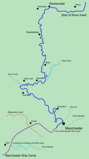
The Irwell Valley in North West England extends from the Forest of Rossendale through the cities of Salford and Manchester. The River Irwell runs through the valley, along with the River Croal.

Ainsworth Mill, Breightmet Cotton mill in Greater Manchester, England

Ainsworth Mill, Breightmet is a mercerising mill near the Breightmet neighborhood of Bolton, Greater Manchester. It was bought by the Lancashire Cotton Corporation in the 1940s as an attempt to develop a cotton finishing presence.

River Irwell Railway Bridge

The River Irwell Railway Bridge was built for the Liverpool & Manchester Railway (L&MR), the world's first passenger railway which used only steam locomotives and operated as a scheduled service, near Water Street in Manchester, England. The stone railway bridge, built in 1830 by George Stephenson, was part of Liverpool Road railway station. The bridge was designated a Grade I listed building on 20 June 1988.

Walverden Water River in Lancashire, England

Walverden Water is a minor river in Lancashire, England. It is approximately 2.6 miles (4.2 km) long and has a catchment area of 5.04 square miles (1,304.23 ha).

References

  1. Ekwall, Eilert (1947). The Concise Oxford Dictionary Of English Place-Names. Oxford: The Clarendon Press. p. 254.
  2. 1 2 James, Alan (2019). The Brittonic Language in the Old North (PDF). Vol. 2. The Scottish Place-Name Society. p. 166.
  3. Farrer, William; Brownbill, J., eds. (1911), "Townships: Manchester (part 2 of 2)", A History of the County of Lancaster: Volume 4, British History Online, pp. 230–251, retrieved 12 August 2012
  4. Farrer, William; Brownbill, J., eds. (1911), "The city and parish of Manchester: Introduction", A History of the County of Lancaster: Volume 4, British History Online, pp. 174–187, retrieved 12 August 2012
  5. Clarke, Steven Reynolds (1830). The New Lancashire Gazetteer. Holborn: Henry Teesdale and Co. p. 72.
  6. Friedrich Engels, The Condition of the Working Class in England , quote: "The south bank of the Irk is here very steep and between fifteen and thirty feet high. On this declivitous hillside there are planted three rows of houses, of which the lowest rise directly out of the river, while the front walls of the highest stand on the crest of the hill in Long Millgate. Among them are mills on the river, in short, the method of construction is as crowded and disorderly here as in the lower part of Long Millgate. Right and left a multitude of covered passages lead from the main street into numerous courts, and he who turns in thither gets into a filth and disgusting grime, the equal of which is not to be found - especially in the courts which lead down to the Irk, and which contain unqualifiedly the most horrible dwellings which I have yet beheld. In one of these courts there stands directly at the entrance, at the end of the covered passage, a privy without a door, so dirty that the inhabitants can pass into and out of the court only by passing through foul pools of stagnant urine and excrement. This is the first court on the Irk above Ducie Bridge - in case any one should care to look into it. Below it on the river there are several tanneries which fill the whole neighbourhood with the stench of animal putrefaction. Below Ducie Bridge the only entrance to most of the houses is by means of narrow, dirty stairs and over heaps of refuse and filth. The first court below Ducie Bridge, known as Allen's Court, was in such a state at the time of the cholera that the sanitary police ordered it evacuated, swept and disinfected with chloride of lime. Dr. Kay gives a terrible description of the state of this court at that time. Since then, it seems to have been partially torn away and rebuilt; at least looking down from Ducie Bridge, the passer-by sees several ruined walls and heaps of debris with some newer houses. The view from this bridge, mercifully concealed from mortals of small stature by a parapet as high as a man, is characteristic for the whole district. At the bottom flows, or rather stagnates, the Irk, a narrow, coal-black, foul-smelling stream, full of debris and refuse, which it deposits on the shallower right bank."
  7. "Irk Valley Junction 1953". Danger Ahead! Historic Railway Disasters. Retrieved 12 December 2007.
Next confluence upstream River Irwell Next confluence downstream
River Croal (West)River Irk River Medlock (East)