Related Research Articles

The geology of Great Britain is renowned for its diversity. As a result of its eventful geological history, Great Britain shows a rich variety of landscapes across the constituent countries of England, Wales and Scotland. Rocks of almost all geological ages are represented at outcrop, from the Archaean onwards.
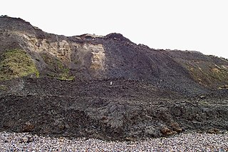
The London Clay Formation is a marine geological formation of Ypresian age which crops out in the southeast of England. The London Clay is well known for its fossil content. The fossils from the lower Eocene rocks indicate a moderately warm climate, the tropical or subtropical flora. Though sea levels changed during the deposition of the clay, the habitat was generally a lush forest – perhaps like in Indonesia or East Africa today – bordering a warm, shallow ocean.

The Lambeth Group is a stratigraphic group, a set of geological rock strata in the London and Hampshire Basins of southern England. It comprises a complex of vertically and laterally varying gravels, sands, silts and clays deposited between 56-55 million years before present during the Ypresian age. It is found throughout the London Basin with a thickness between 10m and 30m and the Hampshire Basin with a thickness between 50m and less than 25m. Although this sequence only crops out on the edges of these basins, the fact that the Lambeth Group underlies some 25% of London at a depth of less than 30m means the formation is of engineering interest for tunnelling and foundations.

The London Basin is an elongated, roughly triangular sedimentary basin approximately 250 kilometres (160 mi) long which underlies London and a large area of south east England, south eastern East Anglia and the adjacent North Sea. The basin formed as a result of compressional tectonics related to the Alpine orogeny during the Palaeogene period and was mainly active between 40 and 60 million years ago.

The Hampshire Basin is a geological basin of Palaeogene age in southern England, underlying parts of Hampshire, the Isle of Wight, Dorset, and Sussex. Like the London Basin to the northeast, it is filled with sands and clays of Paleocene and younger ages and it is surrounded by a broken rim of chalk hills of Cretaceous age.

The geology of Skye in Scotland is highly varied and the island's landscape reflects changes in the underlying nature of the rocks. A wide range of rock types are exposed on the island, sedimentary, metamorphic and igneous, ranging in age from the Archaean through to the Quaternary.

The geology of the Isle of Wight is dominated by sedimentary rocks of Cretaceous and Paleogene age. This sequence was affected by the late stages of the Alpine Orogeny, forming the Isle of Wight monocline, the cause of the steeply-dipping outcrops of the Chalk Group and overlying Paleogene strata seen at The Needles, Alum Bay and Whitecliff Bay.
The geology of Suffolk in eastern England largely consists of a rolling chalk plain overlain in the east by Neogene clays, sands and gravels and isolated areas of Palaeocene sands. A variety of superficial deposits originating in the last couple of million years overlie this 'solid geology'.
The geology of Kent in southeast England largely consists of a succession of northward dipping late Mesozoic and Cenozoic sedimentary rocks overlain by a suite of unconsolidated deposits of more recent origin.
The geology of Rutland in eastern England largely consists of sedimentary rocks of Jurassic age which dip gently eastwards.
The geology of Norfolk in eastern England largely consists of late Mesozoic and Cenozoic sedimentary rocks of marine origin covered by an extensive spread of unconsolidated recent deposits.

Essex is a county in the southeast of England, northeast of London. One of the home counties, it borders Suffolk and Cambridgeshire to the north, Hertfordshire to the west, Kent across the estuary of the River Thames to the south, and London to the southwest. The county town is Chelmsford, the only city in the county. For government statistical purposes Essex is placed in the East of England region.
The geology of Tyne and Wear in northeast England largely consists of a suite of sedimentary rocks dating from the Carboniferous and Permian periods into which were intruded igneous dykes during the later Palaeogene Period.
The geology of West Sussex in southeast England comprises a succession of sedimentary rocks of Cretaceous age overlain in the south by sediments of Palaeogene age. The sequence of strata from both periods consists of a variety of sandstones, mudstones, siltstones and limestones. These sediments were deposited within the Hampshire and Weald basins. Erosion subsequent to large scale but gentle folding associated with the Alpine Orogeny has resulted in the present outcrop pattern across the county, dominated by the north facing chalk scarp of the South Downs. The bedrock is overlain by a suite of Quaternary deposits of varied origin. Parts of both the bedrock and these superficial deposits have been worked for a variety of minerals for use in construction, industry and agriculture.
The geology of Northumberland in northeast England includes a mix of sedimentary, intrusive and extrusive igneous rocks from the Palaeozoic and Cenozoic eras. Devonian age volcanic rocks and a granite pluton form the Cheviot massif. The geology of the rest of the county is characterised largely by a thick sequence of sedimentary rocks of Carboniferous age. These are intruded by both Permian and Palaeogene dykes and sills and the whole is overlain by unconsolidated sediments from the last ice age and the post-glacial period. The Whin Sill makes a significant impact on Northumberland's character and the former working of the Northumberland Coalfield significantly influenced the development of the county's economy. The county's geology contributes to a series of significant landscape features around which the Northumberland National Park was designated.
This article describes the geology of the Broads, an area of East Anglia in eastern England characterised by rivers, marshes and shallow lakes (‘broads’). The Broads is designated as a protected landscape with ‘status equivalent to a national park’.
This article describes the geology of the New Forest, a national park in Hampshire, in Southern England.
The geology of Northumberland National Park in northeast England includes a mix of sedimentary, intrusive and extrusive igneous rocks from the Palaeozoic and Cenozoic eras. Devonian age volcanic rocks and a granite pluton form the Cheviot massif. The geology of the rest of the national park is characterised largely by a thick sequence of sedimentary rocks of Carboniferous age. These are intruded by Permian dykes and sills, of which the Whin Sill makes a significant impact in the south of the park. Further dykes were intruded during the Palaeogene period. The whole is overlain by unconsolidated sediments from the last ice age and the post-glacial period.

The geology of the Isle of Mull in Scotland is dominated by the development during the early Palaeogene period of a ‘volcanic central complex’ associated with the opening of the Atlantic Ocean. The bedrock of the larger part of the island is formed by basalt lava flows ascribed to the Mull Lava Group erupted onto a succession of Mesozoic sedimentary rocks during the Palaeocene epoch. Precambrian and Palaeozoic rocks occur at the island's margins. A number of distinct deposits and features such as raised beaches were formed during the Quaternary period.
References
- ↑ British Geological Survey 1:625,000 scale geological map Bedrock Geology UK South 5th Edn. NERC 2007
- ↑ British Geological Survey 1996 Tectonic map of Britain, Ireland and adjacent areas. Pharaoh et al 1:1500000 (Keyworth, Nottingham: British Geological Survey)
- ↑ British Geological Survey 1:625,000 scale geological map Quaternary Map of the United Kingdom South 1st Edn. 1977