Related Research Articles

Northumberland is a county in Northern England, one of two counties in England which border with Scotland. Notable landmarks in the county include Alnwick Castle, Bamburgh Castle, Hadrian's Wall and Hexham Abbey.

The North Pennines is the northernmost section of the Pennine range of hills which runs north–south through northern England. It lies between Carlisle to the west and Darlington to the east. It is bounded to the north by the Tyne Valley and to the south by the Stainmore Gap.
The Cheviot is an extinct volcano and the highest summit in the Cheviot Hills and in the county of Northumberland. Located in the extreme north of England, it is 1+1⁄4 miles from the Scottish border and, with a height of 2,674 feet above sea-level, is located on the northernmost few miles of the Pennine Way, before the descent into Kirk Yetholm.

Carboniferous Limestone is a collective term for the succession of limestones occurring widely throughout Great Britain and Ireland that were deposited during the Dinantian Epoch of the Carboniferous Period. These rocks formed between 363 and 325 million years ago. Within England and Wales, the entire limestone succession, which includes subordinate mudstones and some thin sandstones, is known as the Carboniferous Limestone Supergroup.

The Whin Sill or Great Whin Sill is a tabular layer of the igneous rock dolerite in County Durham, Northumberland and Cumbria in the northeast of England. It lies partly in the North Pennines Area of Outstanding Natural Beauty and partly in Northumberland National Park and stretches from Teesdale northwards towards Berwick.

The geology of England is mainly sedimentary. The youngest rocks are in the south east around London, progressing in age in a north westerly direction. The Tees-Exe line marks the division between younger, softer and low-lying rocks in the south east and the generally older and harder rocks of the north and west which give rise to higher relief in those regions. The geology of England is recognisable in the landscape of its counties, the building materials of its towns and its regional extractive industries.

The mountains and hills of England comprise very different kinds of terrain, from a mountain range which reaches almost 1,000 metres high, to several smaller areas of lower mountains, foothills and sea cliffs. Most of the major upland areas have been designated as Areas of Outstanding Natural Beauty (AONB) or national parks. The highest and most extensive areas are in the north and west, while the midlands, south-east and east of the country tend to be low-lying.

The Northumberland Coalfield is a coalfield in north-east England. It is continuous with the Durham Coalfield to its south. It extends from Shilbottle in the north to the boundary with County Durham along the River Tyne in the south, beyond which is the Durham Coalfield.
The geology of Monmouthshire in southeast Wales largely consists of a thick series of sedimentary rocks of different types originating in the Silurian, Devonian, Carboniferous, Triassic and Jurassic periods.
The Warwickshire Group is a lithostratigraphic unit of rock strata defined within the British Carboniferous system. Within the Pennine Basin it overlies the Coal Measures Group and is deemed to be of late Westphalian and Stephanian age. In the South Wales Coalfield it consists of the Pennant Sandstone Formation and overlying Grovesend Formation. It contains the youngest Carboniferous rocks in Britain. The name Warwickshire Group is a relatively recent one, replacing a variety of earlier names for the succession of coal-barren red-beds such as Barren Coal Measures and Red Measures which overlie the productive coal measures. It is derived from the Warwickshire Coalfield where they achieve their thickest development.

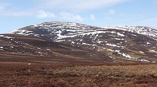
The Cheviot Hills, or sometimes The Cheviots, are a range of uplands straddling the Anglo-Scottish border between Northumberland and the Scottish Borders. The English section is within the Northumberland National Park. The range includes The Cheviot, plus Hedgehope Hill to the east, Windy Gyle to the west, and Cushat Law and Bloodybush Edge to the south.
The geology of Lancashire in northwest England consists in the main of Carboniferous age rocks but with Triassic sandstones and mudstones at or near the surface of the lowlands bordering the Irish Sea though these are largely obscured by Quaternary deposits.
The geology of Merseyside in northwest England largely consists of a faulted sequence of Carboniferous Coal Measures rocks overlain in the west by younger Triassic and Permian age sandstones and mudstones. Glaciation during the present Quaternary Period has left widespread glacial till as well as erosional landforms. Other post-glacial superficial deposits such as river and estuarine alluvium, peat and blown sand are abundant.
The geology of County Durham in northeast England consists of a basement of Lower Palaeozoic rocks overlain by a varying thickness of Carboniferous and Permo-Triassic sedimentary rocks which dip generally eastwards towards the North Sea. These have been intruded by a pluton, sills and dykes at various times from the Devonian Period to the Palaeogene. The whole is overlain by a suite of unconsolidated deposits of Quaternary age arising from glaciation and from other processes operating during the post-glacial period to the present. The geological interest of the west of the county was recognised by the designation in 2003 of the North Pennines Area of Outstanding Natural Beauty as a European Geopark.
The geology of Tyne and Wear in northeast England largely consists of a suite of sedimentary rocks dating from the Carboniferous and Permian periods into which were intruded igneous dykes during the later Palaeogene Period.
The geology of the Isle of Man consists primarily of a thick pile of sedimentary rocks dating from the Ordovician period, together with smaller areas of later sedimentary and extrusive igneous strata. The older strata was folded and faulted during the Caledonian and Acadian orogenies The bedrock is overlain by a range of glacial and post-glacial deposits. Igneous intrusions in the form of dykes and plutons are common, some associated with mineralisation which spawned a minor metal mining industry.
The geology of national parks in Britain strongly influences the landscape character of each of the fifteen such areas which have been designated. There are ten national parks in England, three in Wales and two in Scotland. Ten of these were established in England and Wales in the 1950s under the provisions of the National Parks and Access to the Countryside Act 1949. With one exception, all of these first ten, together with the two Scottish parks were centred on upland or coastal areas formed from Palaeozoic rocks. The exception is the North York Moors National Park which is formed from sedimentary rocks of Jurassic age.
The geology of Northumberland National Park in northeast England includes a mix of sedimentary, intrusive and extrusive igneous rocks from the Palaeozoic and Cenozoic eras. Devonian age volcanic rocks and a granite pluton form the Cheviot massif. The geology of the rest of the national park is characterised largely by a thick sequence of sedimentary rocks of Carboniferous age. These are intruded by Permian dykes and sills, of which the Whin Sill makes a significant impact in the south of the park. Further dykes were intruded during the Palaeogene period. The whole is overlain by unconsolidated sediments from the last ice age and the post-glacial period.
The geology of the Yorkshire Dales National Park in northern England largely consists of a sequence of sedimentary rocks of Ordovician to Permian age. The core area of the Yorkshire Dales is formed from a layer-cake of limestones, sandstones and mudstones laid down during the Carboniferous period. It is noted for its karst landscape which includes extensive areas of limestone pavement and large numbers of caves including Britain's longest cave network.
References
- ↑ British Geological Survey 1:625,000 scale geological map Bedrock Geology UK North 5th Edn. NERC 2007
- ↑ "BGS Lexicon of Named Rock Units - Result Details". Bgs.ac.uk. Retrieved 17 February 2019.
- ↑ Stone, P. et al 2010 British Regional Geology: Northern England (5th edn) (Keyworth, Nottingham: British Geological Survey),pp184-5
- ↑ Stone, P. et al 2010 British Regional Geology: Northern England (5th edn) (Keyworth, Nottingham: British Geological Survey), pp212-3
- ↑ British Geological Survey 1:625,000 scale geological map Quaternary Map of the United Kingdom South 1st Edn. 1977
- ↑ BGS 1:50,000 scale geological map sheets (England and Wales series) sheet 1&2 Berwick-upon-Tweed and Norham & sheet 4 Holy Island