
The geology of Surrey is dominated by sedimentary strata from the Cretaceous, overlaid by clay and superficial deposits from the Cenozoic.
The geology of Surrey is dominated by sedimentary strata from the Cretaceous, overlaid by clay and superficial deposits from the Cenozoic.

During the Early Cretaceous epoch (from about 145 to about 100 million years ago) Surrey alternated between a fresh-to-brackish water embayment depositing Hastings Beds and Weald Clay, comprising shales and mudstones that are often finely banded. Offshore muds (now shales and mudstones) of the Atherfield Clay were deposited followed by shallow marine sands of the Hythe, Sandgate and Folkestone Beds. Where not eroded to lower heights, there is then a marine layer of the sands of the Hythe Beds topped by chert seen on today's remaining Greensand Hills. Instead of the mudstone and sandstone-producing three beds mentioned before Hythe Beds, west of Dorking the marine Bargate Beds made of calcareous (chalk and limestone-rich) sandstone were deposited. The Folkestone Beds contain phosphatic and iron-rich nodules, which locally yield a rich fossil fauna of marine shells.
Then under even deeper seas, Gault Clay and the Upper Greensand were deposited. The Gault Clay contains phosphate-rich nodules in discrete bands and has a rich marine fauna with abundant ammonites, bivalves and gastropods. The Upper Greensand comprises a variety of sediments with fine silts at the base giving way upwards into sandstones.

90 million years ago the North Downs hard chalk was deposited, a white limestone which is over 95% calcium carbonate. It contains thin beds of marl and nodules of flint, either scattered or in bands. The North Downs extending from Farnham to Dover, Kent are formed by this chalk. They now have an often white, almost vertical south-facing slope. [1]
Just before the Paleogene, which included the mass-extinction event of the non-avian dinosaurs, sea levels dropped, exposing Sussex and Kent, and the marine Upnor Beds were deposited in Surrey. In the Paleogene, Southern England rose slightly, and the seas retreated, and the reddish and mottled clays of the Reading Beds were deposited by a large river sand delta system. Later, a rise in sea level, around 50 million years ago, caused widespread deposition, until 2 million years ago, of the London Clay across the County. The London Clay is a bluish-grey marine clay with isolated pockets of fossils especially where chalkier. The youngest part of the London Clay is known as the Claygate Beds and occurs widely in Surrey. This even sandier material represents a transition between the deeper water London Clay and the succeeding shallower water, possibly estuarine, Bagshot Sand. [1]
Major climate changes in Britain causing sea level changes in the last 2.58 million years, with mini Ice Ages, the ice sheets did not extend to Surrey but sand and gravel deposits swept towards the fledgling River Thames were spread in all lower parts. Gravel terraces at various heights on the valley sides are the remnants of successive floodplains, the highest terrace being the oldest and the lowest the youngest. The most prominent terraces mark the former levels of the Thames in north Surrey. Along tributary slopes, a deposit, head, forms the main sediment of latest age. Head comprises angular pieces of rock and soil derived locally from the extensive frost-shattering of rocks and the subsequent movement of this material down valley slopes. Large areas of clay-with-flints, derived from the weathering of material overlying the present day chalk, occur across the North Downs. One particular suite of sediments that occur in the Guildford vale is known as the Headley Formation and comprises gravel and sand on top of the chalk. These sediments contain marine fossils and were probably derived from erosion of the Greensand and Tertiary rocks during the Paleogene. [1]
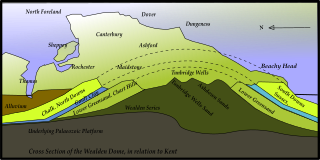
A large geological fold, the Wealden anticline, is the major rock structure in the county. [1] This anticline was formed by the Alpine orogeny about 25 to 12 million years ago.

The northeast of the county, such as the north of Tandridge (district), is in the wide part of the North Downs. Thus from the east, Tatsfield has two western pockets of slightly acid, loamy soils with free drainage otherwise has the expected shallow, lime-rich soil over chalk or limestone of the escarpment with lower parts of the escarpment summit here, where that topsoil has eroded, having slightly acid, loamy and clayey soils with impeded drainage soil. Westward, the shallow lime is found all the way along the North Downs to the western border, past Guildford only a few hundred metres narrow to Farnham Castle and even Dippenhall, the latter accompaniment is found on both sides only to Buckland, well before Dorking. A horseshoe of land including the rise north of Godstone of Godstone Hill that leads to the escarpment is free draining lime-rich loamy soil (i.e. alkaline). Continuing with the Downs, in a broad band, the far northern type soil slopes such as near Croydon come across the Surrey border at Banstead and Ewell, which is free draining, slightly acid but base-rich soils, producing extremely fertile pastures and deciduous woodland, which becomes the edging for both sides of the high escarpment at Box Hill and is just found for a brief while in a middle section in Polesden Lacey then throughout the northern slope carrying on westward. Chipstead, Banstead and Tadworth have the first free draining slightly acid loamy soil that tops the wider downs to Guildford and is found around Dorking and the across the Vale of Holmesdale north of the Greensand Hills.
Equally it is this topsoil north of the Thames across Spelthorne (such as around Ashford) and west of the Thames in the east of Runnymede (such as around Thorpe): here the land is flat flood plain, mostly silt mixed with lime-rich London Clay. [2]
Between the Thames and the North Downs the land is overall slightly lower than south of the Downs but is less in the current flood plain, drained by the tributaries mentioned. There is more loam persisting the further from the alluvial plain of the Thames and tributaries; from the southbank at Thames Ditton (near Hampton Court southwest to Ripley, Send and Old Woking is still more free draining slightly acid loamy soil. Impeded drainage but rarely waterlogged soil features in Addlestone, north Knaphill and around Perry Hill, Worplesdon while Chobham lies in loamy soils with naturally high groundwater producing wet acid meadow and woodland edged by streamside fen/peat marshy brooklands. [2]
Heath: in Esher, Oxshott, Weybridge, Wisley, all around Woking, Brookwood, Deepcut, Pirbright, Frimley, Lightwater, Camberley, Chobham Common, Virginia Water and Ottershaw is naturally wet, very acid sandy and loamy soil which is just 1.9% of English soil and 0.2% of Welsh soil, which gives rise to pines and coniferous landscapes, such as pioneered at Wentworth and Foxhills estate (now spa, hotel, restaurant and golf club) by pro-American Independence statesman Charles James Fox. [2]
South, but not beyond the North Downs and to the south of the Greensand Ridge is slowly permeable loamy/clayey slightly acid but base-rich soil forming a 3–4-mile-wide (5–6 km) band from Ewell and Claygate through Leatherhead, Little Bookham, the north side of Guildford to Farnham, whereas South of the Greensand is some 20–15 miles (30–25 km) thick (with some areas of free then poor drainage around East Grinstead/Felbridge). [2] The Greensand ridge itself has the heath soil above and zones of slightly acid only freely draining sandy soils, which make those areas more densely wooded such as Thursley, Brook, Churt, Seale, Runfold and Puttenham.

For the ship anchorage, see The Downs.

Cranleigh is a village and civil parish, about 8 miles (13 km) southeast of Guildford in Surrey, England. It lies on a minor road east of the A281, which links Guildford with Horsham. It is in the north-west corner of the Weald, a large remnant forest, the main local remnant being Winterfold Forest directly north-west on the northern Greensand Ridge.

The North Downs are a ridge of chalk hills in south east England that stretch from Farnham in Surrey to the White Cliffs of Dover in Kent. Much of the North Downs comprises two Areas of Outstanding Natural Beauty (AONBs): the Surrey Hills and the Kent Downs. The North Downs Way National Trail runs along the North Downs from Farnham to Dover.

The geology of Hertfordshire describes the rocks of the English county of Hertfordshire which are a northern part of the great shallow syncline known as the London Basin. The beds dip in a south-easterly direction towards the syncline's lowest point roughly under the River Thames. The most important formations are the Cretaceous chalks, which are exposed as the high ground in the north and west of the county, and the Cenozoic rocks made up of the Paleocene age Reading beds and Eocene age London Clay that occupies the remaining southern part.

Greensand or green sand is a sand or sandstone which has a greenish color. This term is specifically applied to shallow marine sediment that contains noticeable quantities of rounded greenish grains. These grains are called glauconies and consist of a mixture of mixed-layer clay minerals, such as smectite and glauconite mica. Greensand is also loosely applied to any glauconitic sediment.

Dorset is a county in South West England on the English Channel coast. Covering an area of 2,653 square kilometres (1,024 sq mi); it borders Devon to the west, Somerset to the north-west, Wiltshire to the north-east, and Hampshire to the east. The great variation in its landscape owes much to the underlying geology, which includes an almost unbroken sequence of rocks from 200 to 40 million years ago (Mya) and superficial deposits from 2 Mya to the present. In general, the oldest rocks appear in the far west of the county, with the most recent (Eocene) in the far east. Jurassic rocks also underlie the Blackmore Vale and comprise much of the coastal cliff in the west and south of the county; although younger Cretaceous rocks crown some of the highpoints in the west, they are mainly to be found in the centre and east of the county.

Betchworth is a village and civil parish in the Mole Valley district of Surrey, England. The village centre is on the north bank of the River Mole and south of the A25 road, almost 3 miles (4.8 km) east of Dorking and 3 miles (4.8 km) west of Reigate. London is 19.5 miles (31.4 km) north of the village.

The geology of London comprises various differing layers of sedimentary rock upon which London, England is built.

The Greensand Ridge, also known as the Wealden Greensand is an extensive, prominent, often wooded, mixed greensand/sandstone escarpment in south-east England. Forming part of the Weald, a former dense forest in Sussex, Surrey and Kent, it runs to and from the East Sussex coast, wrapping around the High Weald and Low Weald. It reaches its highest elevation, 294 metres (965 ft), at Leith Hill in Surrey—the second highest point in south-east England, while another hill in its range, Blackdown, is the highest point in Sussex at 280 metres (919 ft). The eastern end of the ridge forms the northern boundary of Romney Marsh.
Kent is the south-easternmost county in England. It is bounded on the north by the River Thames and the North Sea, and on the south by the Straits of Dover and the English Channel. The continent of Europe is 21 miles across the straits.
The London Basin is an elongated, roughly triangular sedimentary basin approximately 250 kilometres (160 mi) long which underlies London and a large area of south east England, south eastern East Anglia and the adjacent North Sea. The basin formed as a result of compressional tectonics related to the Alpine orogeny during the Palaeogene period and was mainly active between 40 and 60 million years ago.

Holmesdale, also known as the Vale of Holmesdale, is a valley in South-East England that falls between the hill ranges of the North Downs and the Greensand Ridge of the Weald, in the counties of Kent and Surrey. It stretches from Folkestone on the Kent coast, through Ashford, Harrietsham, Maidstone, Riverhead/Sevenoaks, Oxted, Godstone, Redhill, Reigate, Dorking, Gomshall, and Guildford – west of which it is also called by the local name of "Puttenham Vale" – as it continues through the village of Puttenham, to the market town of Farnham.
The western Weald is an area of undulating countryside in Hampshire and West Sussex containing a mixture of woodland and heathland areas.
Gatton is a former village and borough in Surrey, England, and an ancient parish. It survives as a sparsely populated, predominantly rural locality, which includes Gatton Park, no more than 12 houses, and two farms on the slopes of the North Downs near Reigate.

The Lower Greensand Group is a geological unit present across large areas of Southern England. It was deposited during the Aptian and Albian stages of the Early Cretaceous. It predominantly consists of sandstone and unconsolidated sand that were deposited in shallow marine conditions.
Holmbury Hill is a wooded area of 261 metres (856 ft) above sea level in Surrey, England, and the site of an Iron Age-period hillfort. The Old Saxon word "holm" can be translated as hill and "bury" means fortified place. It sits along the undulating Greensand Ridge, its summit being 805 feet (245 m) from the elevated and tightly clustered small village of Holmbury St. Mary which was traditionally part of Shere, 8 kilometres (5.0 mi) away.
The geology of East Sussex is defined by the Weald–Artois anticline, a 60 kilometres (37 mi) wide and 100 kilometres (62 mi) long fold within which caused the arching up of the chalk into a broad dome within the middle Miocene, which has subsequently been eroded to reveal a lower Cretaceous to Upper Jurassic stratigraphy. East Sussex is best known geologically for the identification of the first dinosaur by Gideon Mantell, near Cuckfield, to the famous hoax of the Piltdown man near Uckfield.
The geology of Kent in southeast England largely consists of a succession of northward dipping late Mesozoic and Cenozoic sedimentary rocks overlain by a suite of unconsolidated deposits of more recent origin.
The geology of West Sussex in southeast England comprises a succession of sedimentary rocks of Cretaceous age overlain in the south by sediments of Palaeogene age. The sequence of strata from both periods consists of a variety of sandstones, mudstones, siltstones and limestones. These sediments were deposited within the Hampshire and Weald basins. Erosion subsequent to large scale but gentle folding associated with the Alpine Orogeny has resulted in the present outcrop pattern across the county, dominated by the north facing chalk scarp of the South Downs. The bedrock is overlain by a suite of Quaternary deposits of varied origin. Parts of both the bedrock and these superficial deposits have been worked for a variety of minerals for use in construction, industry and agriculture.

Betchworth Quarry and Lime Kilns is a 27-hectare (67-acre) nature reserve west of Betchworth in Surrey. It is managed by the Surrey Wildlife Trust. It is part of the Mole Gap to Reigate Escarpment Site of Special Scientific Interest and Special Area of Conservation.