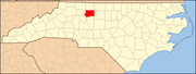
Stokes County is a county located in the U.S. state of North Carolina. As of the 2020 census, the population was 44,520. Its county seat is Danbury.

Forsyth County is located in the northwest Piedmont of the U.S. state of North Carolina. As of the 2020 census, the population was 382,590, making it the fourth-most populous county in North Carolina. Its county seat is Winston-Salem. Forsyth County is part of the Winston-Salem, NC, Metropolitan Statistical Area, which is also included in the Greensboro–Winston-Salem–High Point, NC, Combined Statistical Area. Portions of Forsyth County are in the Yadkin Valley wine region.

Bethania is the oldest municipality in Forsyth County, North Carolina, United States, and was most recently incorporated in 1995, upon the reactivation of the original 1838/1839 town charter. In 2009, Bethania celebrated the 250th anniversary of its establishment in 1759. As of the 2020 census, the town population was 341.
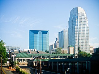
Winston-Salem is a city in and the county seat of Forsyth County, North Carolina, United States. In the 2020 census, the population was 249,545, making it the second-largest municipality in the Piedmont Triad region, the fifth-most populous city in North Carolina, and the 90th-most populous city in the United States. Winston-Salem is home to the tallest office building in the region, 100 North Main Street, formerly known as the Wachovia Building and now known locally as the Wells Fargo Center.

Danbury is a city located in Danbury Township, Stokes County, North Carolina, United States. As of the 2020 census, the city had a total population of 142. It is the county seat of Stokes County. Danbury is located on North Carolina Highway 8/89 approximately 20 miles (32 km) north of Winston-Salem and is the "Gateway to Hanging Rock". The Stokes County Government Center, Arts Council, school board, county jail, a public library, a post office, and other public services are found within the town limits. LifeBrite Community Hospital of Stokes is located about a half mile northwest of the town. North Stokes High School, a big part of town, is located 7.4 miles to the northwest.
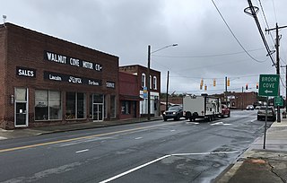
Walnut Cove is a town in Stokes County, North Carolina, United States. The population was 1,536 at the 2020 census.

King is a city in Stokes and Forsyth counties, North Carolina, United States. The population was 7,096 at the 2020 census. King is part of the Piedmont Triad metropolitan area, located 15 miles (24 km) northwest of Winston-Salem.

Tobaccoville is a village in Forsyth and Stokes counties in the U.S. state of North Carolina. The population was 2,209 at the 2020 census. While a Tobaccoville post office was established in 1879, the village was not incorporated until 1991, as a defense against forced annexation of the area by the nearby city of King.

The Piedmont Triad is a metropolitan region in the north-central part of the U.S. state of North Carolina anchored by three cities: Greensboro, Winston-Salem, and High Point. This close group of cities lies in the Piedmont geographical region of the United States and forms the basis of the Greensboro–Winston-Salem–High Point, NC Combined Statistical Area. As of 2012, the Piedmont Triad has an estimated population of 1,611,243 making it the 33rd largest combined statistical area in the United States.

The Yadkin River is one of the longest rivers in the US state of North Carolina, flowing 215 miles (346 km). It rises in the northwestern portion of the state near the Blue Ridge Parkway's Thunder Hill Overlook. Several parts of the river are impounded by dams for water, power, and flood control. The river becomes the Pee Dee River at the confluence of the Uwharrie River south of the community of Badin and east of the town of Albemarle. The river then flows into South Carolina near Cheraw, which is at the Fall Line. The entirety of the Yadkin River and the Great Pee Dee River is part of the Yadkin-Pee Dee River Basin.

Wachovia was the area settled by Moravians in what is now Forsyth County, North Carolina, United States. Of the six 18th-century Moravian "villages of the Lord" established in Wachovia, today only the town of Bethania and city of Winston-Salem exist within the historic Wachovia Tract. The historical tract was somewhat larger than present-day Winston-Salem and somewhat smaller than present-day Forsyth County.

Old Salem is a historic district of Winston-Salem, North Carolina, United States, which was originally settled by the Moravian community in 1766. It features a living-history museum which interprets the restored Moravian community. The non-profit organization began its work in 1950, although some private residents had restored buildings earlier. As the Old Salem Historic District, it was declared a National Historic Landmark (NHL) in 1966, and expanded fifty years later. The district showcases the culture of the Moravian settlement in the Province of North Carolina during the colonial 18th century and post-statehood 19th century via its communal buildings, churches, houses and shops.
Pine Hall is an unincorporated community in Stokes County, North Carolina, United States, approximately ten miles southwest of county seat Danbury, near Belews Lake. Danbury and Sandy Ridge are to the north, with Stokesdale to the east. Kernersville and Walkertown are to the south, with Winston-Salem to the southwest. Walnut Cove and Germanton are located to the west. On March 20, 1998, a EF-1 tornado touched down briefly in the northern part of Pine Hall, north of Route 311 near Morning Star Baptist Church. The walls were knocked from the foundation of the church and windows were blown out because of the pressure. Trees were also knocked and blown over and 3 people were injured. It was on the ground for 1.5 miles before lifting near the Stokes/Rockingham County line. This tornado and system would eventually become the Stoneville Tornado from the 1998 Gainesville-Stoneville tornado outbreak.
Donnaha is an unincorporated community along the Yadkin River in the Old Richmond Township of northwest Forsyth County, North Carolina, United States. Donnaha is named for the last chief of the Sauras.
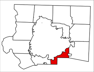
Broadbay Township is one of fifteen townships in Forsyth County, North Carolina, United States. By the requirements of the North Carolina Constitution of 1868, the counties were divided into townships, which included Broadbay Township. The township had a population of 2,002 according to the 2010 census.

The Bethania Historic District encompasses the historic planned center of the town of Bethania, North Carolina. A National Historic Landmark District, it is a rare example of a Moravian linear agricultural village in the United States, planned and founded in 1759. Land use and road patterns of the original plan are still discernible in the community. It was declared a National Historic Landmark in 2001, and is at 500 acres (2.0 km2) the largest historic district in Forsyth County.
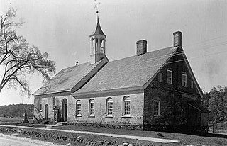
Bethabara Historic District encompasses the surviving buildings and archaeological remains of a small Moravian community, that was first settled in 1753. Located in present-day Forsyth County, North Carolina, it is now a public park of the city of Winston-Salem. It was designated National Historic Landmark in 1999.
Demographics of North Carolina covers the varieties of ethnic groups who reside in North Carolina and relevant trends.

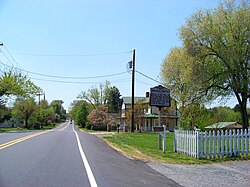
St. Philips Episcopal Church, also known as St. Philips Church, is a historic Episcopal church located on NC 65 and 8 and SR 1957 in Germanton, Stokes County, North Carolina. It was built in 1890, consecrated in 1894, and is a one-story, Gothic Revival style board-and-batten frame building. It features a two-stage corner tower and belfry.
The following is a timeline of the history of the city of Winston-Salem, North Carolina, USA.