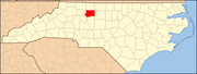
Forsyth County is located in the U.S. state of North Carolina. As of the 2010 census, the population was 350,670, making it the fourth-most populous county in North Carolina. Its county seat is Winston-Salem.

Lafayette County is a county located in the U.S. state of Arkansas. As of the 2010 census, the population was 7,645, making it the third-least populous county in Arkansas. The county seat is Lewisville. Lafayette County was formed on October 15, 1827 and named in honor of the Marquis de Lafayette, a French military hero of the American Revolutionary War. It is a dry county; therefore, the sale of alcohol is prohibited.

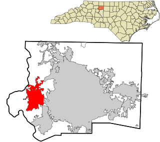
Clemmons is a village in Forsyth County, North Carolina and a suburb of Winston-Salem. The population was 18,627 at the 2010 census, with an estimated population of 20,867 in 2019.
Lewisville is a town in Forsyth County, North Carolina, United States. The population was 12,639 at the 2010 census, up from 8,826 at the 2000 census. It is a Piedmont Triad community.

West Middletown is a borough in Washington County, Pennsylvania, United States. The population was 144 at the 2000 census.
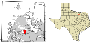
Copper Canyon is a town in Denton County, Texas, United States. Copper Canyon was founded in April 1973. Irving, Texas was the first to have their eyes set on annexing the land of what is now Copper Canyon. When the Town of Flower Mound threatened to annex the ranches and rural homesteads, residents, Bob "Shack" Shackelford, Fielding "Dutch" Schulz, and Paul Vickery were the first to recognize this threat to their simple rural living. These men convinced Bill Ferris, Bob Woodin, Tom Murray and Bob Allen to incorporate the town in an effort to preserve the rural atmosphere and freedom of the community. With the threats of the expansive ranch land being annexed into today's Flower Mound, Texas and facing increasing taxes and regulations, the founding fathers knew it was time to act.

Creek Township is one of thirteen townships in DeWitt County, Illinois, USA. As of the 2010 census, its population was 471 and it contained 206 housing units. The township contains the east half of Weldon Springs State Park.

Old Town Township is one of fifteen townships in Forsyth County, North Carolina, United States. The township had a population of 149 according to the 2010 census.

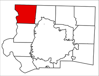
Abbotts Creek Township is one of fifteen townships in Forsyth County, North Carolina, United States. The township had a population of 11,310 according to the 2010 census.

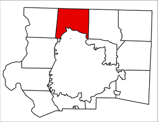
Winston Township is one of fifteen townships in Forsyth County, North Carolina, United States. The township had a population of 229,617, according to the 2010 census.
Old Richmond Township is one of fifteen townships in Forsyth County, North Carolina, United States. The township had a population of 5,236 according to the 2010 census.
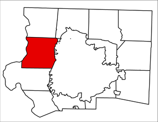
Bethania Township is one of fifteen townships in Forsyth County, North Carolina, United States. The township had a population of 9,200 according to the 2010 census.

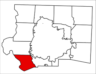
South Fork Township is one of fifteen townships in Forsyth County, North Carolina, United States. The township had a population of 2,576 according to the 2010 census.
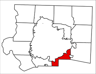
Clemmonsville Township is one of fifteen townships in Forsyth County, North Carolina, United States. The township had a population of 14,927 according to the 2010 census.
Vienna Township is one of fifteen townships in Forsyth County, North Carolina, United States. The township had a population of 10,243 according to the 2010 census.
Broadbay Township is one of fifteen townships in Forsyth County, North Carolina, United States. The township had a population of 2,002 according to the 2010 census.

Kernersville Township is one of fifteen townships in Forsyth County, North Carolina, United States. The township had a population of 30,386 according to the 2010 census.

Salem Chapel Township is one of fifteen townships in Forsyth County, North Carolina, United States. The township had a population of 6,808 according to the 2010 census.

Belews Creek Township is one of fifteen townships in Forsyth County, North Carolina, United States. The township had a population of 2,647 according to the 2010 census.
Lincoln Township is a former township of Emmons County, North Dakota, United States. The township recorded a population of 28 during the 2000 Census.