Goldsboro, Maryland

Last updated

Goldsboro, Maryland
Goldsboro Town Hall and PO MD1.jpg
The Goldsboro town hall and post office in 2016
Logo of Goldsboro, Maryland.png
Caroline County Maryland Incorporated and Unincorporated areas Goldsboro Highlighted.svg
Location of Goldsboro, Maryland
USA Maryland location map.svg
Red pog.svg
Goldsboro
Location within the U.S. state of Maryland
Usa edcp location map.svg
Red pog.svg
Goldsboro
Goldsboro (the United States)
Coordinates: 39°2′8″N75°47′14″W / 39.03556°N 75.78722°W / 39.03556; -75.78722
Country Flag of the United States.svg  United States of America
State Flag of Maryland.svg  Maryland
County Flag of Caroline County, Maryland.svg Caroline
Incorporated 1906 [1]
Government
  MayorBucktooth Dhue [1]
Area
[2]
  Total0.79 sq mi (2.05 km2)
  Land0.78 sq mi (2.02 km2)
  Water0.01 sq mi (0.03 km2)
Elevation
56 ft (17 m)
Population
 (2020)
  Total211
  Density269.82/sq mi (104.24/km2)
Time zone UTC-5 (Eastern (EST))
  Summer (DST) UTC-4 (EDT)
ZIP code
21636
Area code 410
FIPS code 24-33950
GNIS feature ID0590343

Goldsboro is a town in Caroline County, Maryland, United States. William James Yeager is the current mayor. The population was 246 at the 2010 United States Census. The zip code is 21636. First known as Oldtown, it was renamed in 1870 for the prominent Goldsborough family who owned land in the area. Castle Hall was listed on the National Register of Historic Places in 1975. [3]

Contents

Goldsboro was the home of Carleton Gooden, a national hiking personality with the trail name of Ragged Robin. Among other feats, in 1978 he completed the Appalachian Trail approaching the age of 60.

Geography

Goldsboro is located at 39°2′8″N75°47′14″W / 39.03556°N 75.78722°W / 39.03556; -75.78722 (39.035483, -75.787085). [4]

According to the United States Census Bureau, the town has a total area of 0.75 square miles (1.94 km2), of which 0.74 square miles (1.92 km2) is land and 0.01 square miles (0.03 km2) is water. [5]

MD 311 northbound in Goldsboro 2017-08-21 13 45 20 View north along Maryland State Route 311 (Main Street) at Maryland State Route 313 (Oldtown Road) in Goldsboro, Caroline County, Maryland.jpg
MD 311 northbound in Goldsboro

Transportation

The primary means of travel to and from Goldsboro is by road. Three state highways serve the town: Maryland Route 313, which, while signed north-south, comes in from the south but turns toward the west within the town; Maryland Route 311, which heads north out of town from MD 313; and Maryland Route 287, which departs eastward from MD 313 in Goldsboro.

Demographics

Historical population
CensusPop.Note
1910 201
1920 22411.4%
1930 211−5.8%
1940 197−6.6%
1950 1980.5%
1960 2043.0%
1970 23113.2%
1980 188−18.6%
1990 185−1.6%
2000 21616.8%
2010 24613.9%
2020 211−14.2%
U.S. Decennial Census [6]

2010 census

As of the census [7] of 2010, there were 246 people, 87 households, and 69 families living in the town. The population density was 332.4 inhabitants per square mile (128.3/km2). There were 97 housing units at an average density of 131.1 per square mile (50.6/km2). The racial makeup of the town was 87.0% White, 4.9% African American, 0.4% Native American, 7.3% from other races, and 0.4% from two or more races. Hispanic or Latino of any race were 8.1% of the population.

There were 87 households, of which 43.7% had children under the age of 18 living with them, 54.0% were married couples living together, 18.4% had a female householder with no husband present, 6.9% had a male householder with no wife present, and 20.7% were non-families. 19.5% of all households were made up of individuals, and 12.6% had someone living alone who was 65 years of age or older. The average household size was 2.83 and the average family size was 3.10.

The median age in the town was 34 years. 30.5% of residents were under the age of 18; 7.6% were between the ages of 18 and 24; 31.2% were from 25 to 44; 15.9% were from 45 to 64; and 14.6% were 65 years of age or older. The gender makeup of the town was 46.7% male and 53.3% female.

2000 census

As of the census [8] of 2000, there were 216 people, 77 households, and 58 families living in the town. The population density was 1,221.5 inhabitants per square mile (471.6/km2). There were 84 housing units at an average density of 475.0 per square mile (183.4/km2). The racial makeup of the town was 93.98% White, 5.56% African American, and 0.46% from two or more races. Hispanic or Latino of any race were 2.78% of the population.

There were 77 households, out of which 37.7% had children under the age of 18 living with them, 54.5% were married couples living together, 13.0% had a female householder with no husband present, and 23.4% were non-families. 20.8% of all households were made up of individuals, and 7.8% had someone living alone who was 65 years of age or older. The average household size was 2.81 and the average family size was 3.17.

In the town, the population was spread out, with 31.5% under the age of 18, 5.6% from 18 to 24, 31.0% from 25 to 44, 21.3% from 45 to 64, and 10.6% who were 65 years of age or older. The median age was 32 years. For every 100 females, there were 98.2 males. For every 100 females age 18 and over, there were 102.7 males.

The median income for a household in the town was $39,500, and the median income for a family was $38,750. Males had a median income of $27,083 versus $23,750 for females. The per capita income for the town was $14,548. About 5.1% of families and 9.6% of the population were below the poverty line, including 21.7% of those under the age of eighteen and none of those 65 or over.

Related Research Articles

<span class="mw-page-title-main">Benton, Maine</span> Town in the state of Maine, United States

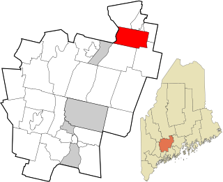
Benton is a town in Kennebec County, Maine, United States. It was formed in 1842, as a subdivision of the town of Clinton. The population was 2,715 at the 2020 census. The town was named for Missouri Senator Thomas Hart Benton.

<span class="mw-page-title-main">Hillsboro, Maryland</span> Town in Maryland

Hillsboro is a town in Caroline County, Maryland, United States. The population was 161 at the 2010 United States Census. Daffin House and St. Paul's Episcopal Church were listed on the National Register of Historic Places in 1975.

<span class="mw-page-title-main">Preston, Maryland</span> Town in Maryland

Preston is a town in Caroline County, Maryland, United States. The population was 719 at the 2010 census.

<span class="mw-page-title-main">Union Bridge, Maryland</span> Town in Maryland, United States

Union Bridge is a town in Carroll County, Maryland, United States. The population was 936 at the 2020 census.

<span class="mw-page-title-main">Cecilton, Maryland</span> Town in Maryland, United States

Cecilton is a town in Cecil County, Maryland, United States. The population was 663 at the 2010 census.

<span class="mw-page-title-main">Charlestown, Maryland</span> Town in Maryland, United States

Charlestown is a town in Cecil County, Maryland, United States. The population was 1,183 at the 2010 census.

<span class="mw-page-title-main">Eldorado, Maryland</span> Town in Maryland, United States

EldoradoEL-də-RAY-doh is a town in Dorchester County, Maryland, United States. The population was 45 at the 2020 census, making it the second smallest town in Maryland.

<span class="mw-page-title-main">Galestown, Maryland</span> Town in Maryland, United States

Galestown is a town in Dorchester County, Maryland, United States. The population was 138 at the 2010 census.

<span class="mw-page-title-main">Secretary, Maryland</span> Town in Maryland, United States

Secretary is a town in Dorchester County, Maryland, United States. The population was 535 at the 2010 census.

<span class="mw-page-title-main">Loch Lynn Heights, Maryland</span> Town in Maryland, United States

Loch Lynn Heights is a town in Garrett County, Maryland, United States. The population was 493 at the 2020 census.

<span class="mw-page-title-main">Barclay, Maryland</span> Town in Maryland, United States

Barclay is a town in Queen Anne's County, Maryland, United States. The population was 120 at the 2010 census.

<span class="mw-page-title-main">Mardela Springs, Maryland</span> Town in Maryland, United States

Mardela Springs is a town in Wicomico County, Maryland, United States. The population was 357 at the 2010 census. It is included in the Salisbury, Maryland-Delaware Metropolitan Statistical Area.

<span class="mw-page-title-main">Pittsville, Maryland</span> Town in Maryland, United States

Pittsville is a town in Wicomico County, Maryland, United States. The population was 1,417 at the 2010 census. It is included in the Salisbury, Maryland-Delaware Metropolitan Statistical Area.

<span class="mw-page-title-main">Sharptown, Maryland</span> Town in Maryland, United States

Sharptown is a town in Wicomico County, Maryland, United States. The population was 651 at the 2010 census. It is included in the Salisbury, Maryland-Delaware Metropolitan Statistical Area.

<span class="mw-page-title-main">Willards, Maryland</span> Town in Maryland, United States

Willards is a town in Wicomico County, Maryland, United States. The population was 958 at the 2010 census. It is included in the Salisbury, Maryland-Delaware Metropolitan Statistical Area.

<span class="mw-page-title-main">Wendell, Minnesota</span> City in Minnesota, United States

Wendell is a city in Grant County, Minnesota, United States. The population was 167 at the 2010 census.

<span class="mw-page-title-main">Fairfield, Pennsylvania</span> Borough in Pennsylvania, United States

Fairfield is a borough in Adams County, Pennsylvania, United States. The population was 526 at the 2020 census.

<span class="mw-page-title-main">Troutville, Pennsylvania</span> Borough in Pennsylvania, United States

Troutville is a borough in Clearfield County, Pennsylvania, United States. The population was 230 at the 2020 census.

<span class="mw-page-title-main">Springville, Wisconsin</span> Town in Wisconsin, United States

Springville is a town in Adams County in the U.S. state of Wisconsin. The population was 1,318 at the 2010 census.

<span class="mw-page-title-main">Templeville, Maryland</span> Town in Maryland, United States

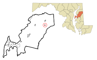
Templeville is a town in Caroline and Queen Anne's counties, Maryland, United States. Templeville is located near the Maryland-Delaware line. The population was 138 at the 2010 census. It was known as Bullock Town until the name was changed in 1847. The name Templeville derives from the Temple family, whose most famous member was Governor William Temple of Delaware.

References

  1. 1 2 "Goldsboro". Maryland Manual. Retrieved June 25, 2017.
  2. "2020 U.S. Gazetteer Files". United States Census Bureau. Retrieved April 26, 2022.
  3. "National Register Information System". National Register of Historic Places . National Park Service. April 15, 2008.
  4. "US Gazetteer files: 2010, 2000, and 1990". United States Census Bureau. February 12, 2011. Retrieved April 23, 2011.
  5. "US Gazetteer files 2010". United States Census Bureau. Archived from the original on January 25, 2012. Retrieved January 25, 2013.
  6. "Census of Population and Housing". Census.gov. Retrieved June 4, 2015.
  7. "U.S. Census website". United States Census Bureau . Retrieved January 25, 2013.
  8. "U.S. Census website". United States Census Bureau . Retrieved January 31, 2008.