Hillsboro, Maryland

Last updated

Hillsboro, Maryland
St Pauls Hillsboro.jpg
St. Paul's Episcopal Church in Hillsboro
Seal of Hillsboro, Maryland.png
Logo of Hillsboro, Maryland.png
Caroline County Maryland Incorporated and Unincorporated areas Hillsboro Highlighted.svg
Location of Hillsboro, Maryland
USA Maryland location map.svg
Red pog.svg
Hillsboro
Location within the U.S. state of Maryland
Usa edcp location map.svg
Red pog.svg
Hillsboro
Hillsboro (the United States)
Coordinates: 38°54′59″N75°56′29″W / 38.91639°N 75.94139°W / 38.91639; -75.94139
Country Flag of the United States.svg  United States of America
State Flag of Maryland.svg  Maryland
County Flag of Caroline County, Maryland.svg Caroline
Incorporated 1853 [1]
Area
[2]
  Total0.14 sq mi (0.35 km2)
  Land0.14 sq mi (0.35 km2)
  Water0.00 sq mi (0.00 km2)
Elevation
39 ft (12 m)
Population
 (2020)
  Total128
  Density948.15/sq mi (365.27/km2)
Time zone UTC-5 (Eastern (EST))
  Summer (DST) UTC-4 (EDT)
ZIP code
21641
Area code 410
FIPS code 24-39175
GNIS feature ID0584985

Hillsboro is a town in Caroline County, Maryland, United States. The population was 161 at the 2010 United States Census. Daffin House and St. Paul's Episcopal Church were listed on the National Register of Historic Places in 1975. [3]

Contents

History

Hillsboro is the oldest town in Caroline County. Evidence shows that as early as 1694 there was an Anglican chapel-of-ease located on the Eastern bank of the Tuckahoe.

Commercially Hillsboro was the site of a tobacco warehouse, one or more general stores, a shoe factory, and a tavern, but its chief claim to fame lies within the spiritual and cultural fields.

Painter Charles Willson Peale briefly resided in Hillsboro.

The first newspaper to be published in Caroline County was published in Hillsboro in 1831 by Lucas Brothers. [4]

Hillsboro previously known as Tuckahoe Bridge was named in the honor of Lord Hillsboro of the Calvert Family. In 1804 there was a fever epidemic in Hillsboro then again in 1816; both occurred in the same house the Seller residence. Hillsboro was the site of the Tri-County fair and the meeting place of Congressional Conventions. [5]

MD 404 Alt. eastbound in Hillsboro 2022-06-23 17 11 31 View east along Maryland State Route 404 Alternate (Hillsboro Road) at Maple Avenue in Hillsboro, Caroline County, Maryland.jpg
MD 404 Alt. eastbound in Hillsboro

Transportation

The main method of transport to and from Hillsboro is by road. Maryland Route 404 Alternate is the only state highway serving the town. Maryland Route 404 and Maryland Route 480 pass just outside the town limits to the north and northeast.

Geography

Hillsboro is located at 38°54′59″N75°56′29″W / 38.91639°N 75.94139°W / 38.91639; -75.94139 (38.916284, -75.941354). [6]

According to the United States Census Bureau, the town has a total area of 0.15 square miles (0.39 km2), all land. [7]

Climate

The climate in this area is characterized by hot, humid summers and generally mild to cool winters. According to the Köppen Climate Classification system, Hillsboro has a humid subtropical climate, abbreviated "Cfa" on climate maps. [8]

Demographics

Historical population
CensusPop.Note
1880 264
1890 174−34.1%
1900 19612.6%
1910 2096.6%
1920 2226.2%
1930 200−9.9%
1940 181−9.5%
1950 179−1.1%
1960 20112.3%
1970 177−11.9%
1980 1801.7%
1990 164−8.9%
2000 163−0.6%
2010 161−1.2%
2020 128−20.5%
U.S. Decennial Census [9]

2010 census

As of the census [10] of 2010, there were 161 people, 68 households, and 46 families living in the town. The population density was 1,073.3 inhabitants per square mile (414.4/km2). There were 75 housing units at an average density of 500.0 per square mile (193.1/km2). The racial makeup of the town was 96.3% White, 2.5% African American, and 1.2% from other races. Hispanic or Latino of any race were 3.1% of the population.

There were 68 households, of which 32.4% had children under the age of 18 living with them, 45.6% were married couples living together, 14.7% had a female householder with no husband present, 7.4% had a male householder with no wife present, and 32.4% were non-families. 26.5% of all households were made up of individuals, and 10.3% had someone living alone who was 65 years of age or older. The average household size was 2.37 and the average family size was 2.78.

The median age in the town was 38.3 years. 22.4% of residents were under the age of 18; 10.6% were between the ages of 18 and 24; 29.9% were from 25 to 44; 26% were from 45 to 64; and 11.2% were 65 years of age or older. The gender makeup of the town was 47.2% male and 52.8% female.

2000 census

At the 2000 census, [11] there were 163 people, 71 households and 45 families living in the town. The population density was 1,140.6 inhabitants per square mile (440.4/km2). There were 78 housing units at an average density of 545.8 per square mile (210.7/km2). The racial makeup of the town was 98.16% White, 1.23% African American, and 0.61% from two or more races. Hispanic or Latino of any race were 0.61% of the population.

There were 71 households, of which 29.6% had children under the age of 18 living with them, 52.1% were married couples living together, 8.5% had a female householder with no husband present, and 36.6% were non-families. 29.6% of all households were made up of individuals, and 11.3% had someone living alone who was 65 years of age or older. The average household size was 2.30 and the average family size was 2.71.

Age distribution was 20.9% under the age of 18, 9.8% from 18 to 24, 33.1% from 25 to 44, 23.3% from 45 to 64, and 12.9% who were 65 years of age or older. The median age was 37 years. For every 100 females, there were 94.0 males. For every 100 females age 18 and over, there were 87.0 males.

The median household income was $29,583, and the median family income was $35,500. Males had a median income of $29,167 versus $20,000 for females. The per capita income for the town was $16,318. None of the families and 9.5% of the population were living below the poverty line, including no under eighteens and 11.1% of those over 64.

Communities

Related Research Articles

<span class="mw-page-title-main">Caroline County, Maryland</span> County in Maryland, United States

Caroline County is a rural county located in the U.S. state of Maryland on its Eastern Shore. As of the 2020 census, the population was 33,293. Its county seat is Denton.

Wesley is a town in Washington County, Maine, United States. The town was named after John Wesley, founder of the English Methodist movement. The population was 122 at the 2020 census.

<span class="mw-page-title-main">Denton, Maryland</span> Town in Maryland

Denton is a town in Caroline County, Maryland, United States. The population of Denton was 4,418 as of the 2010 United States Census, and it is the county seat of Caroline County.

<span class="mw-page-title-main">Federalsburg, Maryland</span> Town in Maryland

Federalsburg is a town in Caroline County, Maryland, United States. The population was 2,739 at the 2010 United States Census. It has one high school, Colonel Richardson High School.

<span class="mw-page-title-main">Goldsboro, Maryland</span> Town in Maryland

Goldsboro is a town in Caroline County, Maryland, United States. William James Yeager is the current mayor. The population was 246 at the 2010 United States Census. The zip code is 21636. First known as Oldtown, it was renamed in 1870 for the prominent Goldsborough family who owned land in the area. Castle Hall was listed on the National Register of Historic Places in 1975.

<span class="mw-page-title-main">Greensboro, Maryland</span> Town in Maryland

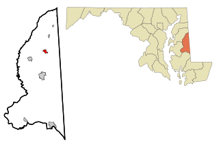
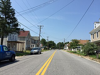
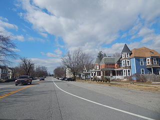
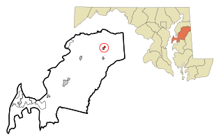
Greensboro is a town located on the banks of the Choptank River in Caroline County, Maryland, United States. The population was 1,931 at the 2010 United States Census. The ZIP code is 21639. The primary phone exchange is 482 and the area code is 410. The town is served by Maryland Routes 480 and 313.

<span class="mw-page-title-main">Marydel, Maryland</span> Town in Maryland

Marydel is an incorporated town in Caroline County, Maryland, United States. The population was 141 at the 2010 United States Census. Its name is a portmanteau, after its location, being partially located in Maryland and partially in Delaware. Marydel was originally known as Halltown.

<span class="mw-page-title-main">Preston, Maryland</span> Town in Maryland

Preston is a town in Caroline County, Maryland, United States. The population was 719 at the 2010 census.

<span class="mw-page-title-main">Ridgely, Maryland</span> Town in Maryland

Ridgely is a town in Caroline County, Maryland, United States. The population was 1,639 at the 2010 census.

<span class="mw-page-title-main">Sudlersville, Maryland</span> Town in Maryland, United States

Sudlersville is a town in the far northeastern corner of Queen Anne's County, Maryland, United States. The ZIP code is 21668 and the area code is 410. The population was 497 at the 2010 census. It is perhaps best known as the hometown of Baseball Hall Of Fame slugger Jimmie Foxx. Other famous residents include astronomer and mathematician Simon Newcomb.

<span class="mw-page-title-main">Princess Anne, Maryland</span> Town in Maryland, United States

Princess Anne is a town in Somerset County, Maryland, United States, that also serves as its county seat. Its population was 3,290 at the 2010 census. It is included in the Salisbury, Maryland–Delaware Metropolitan Statistical Area. It is home to the University of Maryland Eastern Shore and the Teackle Mansion.

<span class="mw-page-title-main">Cordova, Maryland</span> Census-designated place in Maryland, United States

Cordova is a census-designated place (CDP) in Talbot County, Maryland, United States. The population was 551 at the 2020 census, down from 592 at the 2000 census.

<span class="mw-page-title-main">Mardela Springs, Maryland</span> Town in Maryland, United States

Mardela Springs is a town in Wicomico County, Maryland, United States. The population was 357 at the 2010 census. It is included in the Salisbury, Maryland-Delaware Metropolitan Statistical Area.

<span class="mw-page-title-main">West Ocean City, Maryland</span> CDP in Maryland, United States

West Ocean City is a census-designated place (CDP) in Worcester County, Maryland, United States. The population was 4,375 at the 2010 census. It is part of the Salisbury, Maryland-Delaware Metropolitan Statistical Area.

<span class="mw-page-title-main">Hillsboro, Ohio</span> City in Ohio, United States

Hillsboro is a city in and the county seat of Highland County, Ohio, United States, approximately 35 miles (56 km) west of Chillicothe and 50 miles (80 km) east of Cincinnati. The population was 6,481 at the 2020 census.

<span class="mw-page-title-main">Snow Shoe Township, Pennsylvania</span> Township in Pennsylvania, United States

Snow Shoe Township is a township in Centre County, Pennsylvania, United States. It is part of the State College, Pennsylvania Metropolitan Statistical Area. The population was 1,638 at the 2020 census.

<span class="mw-page-title-main">Heidelberg Township, York County, Pennsylvania</span> Township in Pennsylvania, United States

Heidelberg Township is a township in York County, Pennsylvania, United States. The township was erected in 1750 and encompassed the land grant known as Digges' Choice, a warrant granted to John Digges in 1727 by the colonial-era Province of Maryland, prior to the time the Mason-Dixon line fixed the final boundary between Maryland and Pennsylvania. The population of Heidelberg Township was 3,027 at the 2020 census.

<span class="mw-page-title-main">Jackson Township, York County, Pennsylvania</span> Township in Pennsylvania, United States

Jackson Township is a township in York County, Pennsylvania, United States. The population was 8,737 at the 2020 census. It was founded in 1853 from parts of Paradise Township. Jackson Township education is served by the Spring Grove Area School District. Police coverage is provided by Northern York County Regional Police Department, and EMS is provided by Spring Grove Area Ambulance. The township is home to York Airport.

<span class="mw-page-title-main">Templeville, Maryland</span> Town in Maryland, United States

Templeville is a town in Caroline and Queen Anne's counties, Maryland, United States. Templeville is located near the Maryland-Delaware line. The population was 138 at the 2010 census. It was known as Bullock Town until the name was changed in 1847. The name Templeville derives from the Temple family, whose most famous member was Governor William Temple of Delaware.

<span class="mw-page-title-main">Queen Anne, Maryland</span> Town in Maryland, United States of America

Queen Anne is a town in Queen Anne's and Talbot counties in the U.S. state of Maryland. The population was 222 at the 2010 census.

References

  1. "Hillsboro". Maryland Manual. Retrieved June 25, 2017.
  2. "2020 U.S. Gazetteer Files". United States Census Bureau. Retrieved April 26, 2022.
  3. "National Register Information System". National Register of Historic Places . National Park Service. April 15, 2008.
  4. Clark. The Eastern Shore of Maryland And Virginia. Lewis Historical Publishing Company Inc. p. 1108.
  5. Cochrane, Laura C. History of Caroline County. Federalsburg, MD: The J.W Stowell Printing Co. pp. 289–297.
  6. "US Gazetteer files: 2010, 2000, and 1990". United States Census Bureau. February 12, 2011. Retrieved April 23, 2011.
  7. "US Gazetteer files 2010". United States Census Bureau. Archived from the original on January 12, 2012. Retrieved January 25, 2013.
  8. Climate Summary for Hillsboro, Maryland
  9. "Census of Population and Housing". Census.gov. Retrieved June 4, 2015.
  10. "U.S. Census website". United States Census Bureau . Retrieved January 25, 2013.
  11. "U.S. Census website". United States Census Bureau . Retrieved January 31, 2008.