Marydel, Maryland

Last updated

Marydel, Maryland
2017-08-21 13 58 11 View west along Maryland State Route 821 (Main Street) at Railroad Avenue in Marydel, Caroline County, Maryland.jpg
Main Street in Marydel
Caroline County Maryland Incorporated and Unincorporated areas Marydel Highlighted.svg
Location of Marydel, Maryland
USA Maryland location map.svg
Red pog.svg
Marydel
Location within the U.S. state of Maryland
Usa edcp location map.svg
Red pog.svg
Marydel
Marydel (the United States)
Coordinates: 39°6.8′N75°44.8′W / 39.1133°N 75.7467°W / 39.1133; -75.7467
Country Flag of the United States.svg  United States of America
State Flag of Maryland.svg  Maryland
County Flag of Caroline County, Maryland.svg Caroline
Incorporated 1929
Area
[1]
  Total0.12 sq mi (0.31 km2)
  Land0.12 sq mi (0.31 km2)
  Water0.00 sq mi (0.00 km2)
Elevation
59 ft (18 m)
Population
 (2020)
  Total176
  Density1,491.53/sq mi (574.91/km2)
Time zone UTC-5 (Eastern (EST))
  Summer (DST) UTC-4 (EDT)
ZIP code
21649
Area code 410
FIPS code 24-51025
GNIS feature ID0590751

Marydel is an incorporated town in Caroline County, Maryland, United States. [2] [3] The population was 141 at the 2010 United States Census. Its name is a portmanteau, after its location, being partially located in Maryland and partially in Delaware. Marydel was originally known as Halltown.

Contents

Publisher James Gordon Bennett Jr. participated in a duel near Marydel in 1877.

Geography

Marydel is located at 39°6.8′N75°44.8′W / 39.1133°N 75.7467°W / 39.1133; -75.7467 (39.1130, -75.7468). [4]

According to the United States Census Bureau, the town has a total area of 0.08 square miles (0.21 km2), all land. [5]

History

The town of Marydel was settled by Austro-Hungarian Catholic farmers circa 1914, around the time that the Austro-Hungarian Empire was about to plunge Europe into World War I, and some immigrants from that area came to the United States. In recent times, beginning in the 1990s, the town became home to a large community of Hispanic immigrants of Guatemalan descent. The majority of these Guatemalan immigrants came from an agricultural, rural, mountainous regions in Guatemala (specifically rural San Marcos), making them feel at home in rural, agricultural (though not mountainous) Caroline County. This community is primarily Spanish speaking, with some of the Guatemalan Mam dialect mixed in. Many of Marydel's Guatemalans have become permanent residents and American citizens. [6] [7]

Transportation

MD 454 northbound in Marydel 2022-06-22 13 39 30 View north along Maryland State Route 454 (Crown Stone Road) at Maryland State Route 311 (Halltown Road) in Marydel, Caroline County, Maryland.jpg
MD 454 northbound in Marydel

The primary means of travel to and from Marydel is by road, and three state highways serve the town. Maryland Route 311 travels south from Marydel, and Maryland Route 454 travels northwestward. Maryland Route 821 follows Main Stree through central Marydel. In addition, Delaware Route 8 ends at the town and state line and heads eastward from Marydel.

Demographics

Historical population
CensusPop.Note
1880 98
1930 127
1940 78−38.6%
1950 11041.0%
1960 13018.2%
1970 17635.4%
1980 152−13.6%
1990 143−5.9%
2000 1472.8%
2010 141−4.1%
2020 17624.8%
U.S. Decennial Census [8]

2010 census

As of the census [9] of 2010, there were 141 people, 36 households, and 24 families living in the town. The population density was 1,762.5 inhabitants per square mile (680.5/km2). There were 50 housing units at an average density of 625.0 per square mile (241.3/km2). The racial makeup of the town was 46.1% White, 3.5% African American, 0.7% Native American, 1.4% Asian, 46.1% from other races, and 2.1% from two or more races. Hispanic or Latino of any race were 53.9% of the population.

There were 36 households, of which 44.4% had children under the age of 18 living with them, 58.3% were married couples living together, 2.8% had a female householder with no husband present, 5.6% had a male householder with no wife present, and 33.3% were non-families. 22.2% of all households were made up of individuals, and 13.9% had someone living alone who was 65 years of age or older. The average household size was 3.92 and the average family size was 4.83.

The median age in the town was 26.1 years. 36.2% of residents were under the age of 18; 12.6% were between the ages of 18 and 24; 25.5% were from 25 to 44; 14.8% were from 45 to 64; and 10.6% were 65 years of age or older. The gender makeup of the town was 51.8% male and 48.2% female.

2000 census

As of the census [10] of 2000, there were 147 people, 47 households, and 32 families living in the town. The population density was 2,353.5 inhabitants per square mile (908.7/km2). There were 52 housing units at an average density of 832.5 per square mile (321.4/km2). The racial makeup of the town was 85.71% White, 6.80% African American, 2.72% Native American, 0.68% Asian, and 4.08% from two or more races. Hispanic or Latino of any race were 8.16% of the population.

There were 47 households, out of which 38.3% had children under the age of 18 living with them, 48.9% were married couples living together, 17.0% had a female householder with no husband present, and 29.8% were non-families. 25.5% of all households were made up of individuals, and 8.5% had someone living alone who was 65 years of age or older. The average household size was 3.00 and the average family size was 3.42.

In the town, the population was spread out, with 28.6% under the age of 18, 12.2% from 18 to 24, 31.3% from 25 to 44, 18.4% from 45 to 64, and 9.5% who were 65 years of age or older. The median age was 32 years. For every 100 females, there were 116.2 males. For every 100 females age 18 and over, there were 133.3 males.

The median income for a household in the town was $25,250, and the median income for a family was $26,500. Males had a median income of $22,083 versus $12,083 for females. The per capita income for the town was $12,379. There were 20.8% of families and 16.5% of the population living below the poverty line, including 24.2% of under eighteens and none of those over 64.

See also

Related Research Articles

<span class="mw-page-title-main">Stockholm, Wisconsin</span> Village in Wisconsin, United States

Stockholm is a village in Pepin County, Wisconsin, United States, founded in 1854 by immigrants from Karlskoga, Sweden, who named it after their country's capital. The population was 78 at the 2020 census. The village is located within the Town of Stockholm.

<span class="mw-page-title-main">Rising Sun, Indiana</span> City in Indiana, United States

Rising Sun is a city in Randolph Township and the county seat of Ohio County, Indiana, United States, along the Ohio River. It is also the only incorporated community in the county. The population of Rising Sun was 2,304 at the 2010 census.

<span class="mw-page-title-main">Eagle Lake, Maine</span> Town in the state of Maine, United States

Eagle Lake is a town in Aroostook County, Maine, United States. The population was 772 at the 2020 census. The town was named by a body of troops heading from Bangor to the Aroostook War for the many eagles that they saw around the lake. A total of 49.0% of the population speaks French, reflecting a trend in Northeastern Maine.

<span class="mw-page-title-main">Merrill, Maine</span> Town in the state of Maine, United States

Merrill is a town in Aroostook County, Maine, United States. The population was 208 at the 2020 census.

<span class="mw-page-title-main">Sherman, Maine</span> Town in the state of Maine, United States

Sherman is a town in Aroostook County, Maine, United States. The population was 815 at the 2020 census.

<span class="mw-page-title-main">Westmanland, Maine</span> Town in the state of Maine, United States

Westmanland is a town in Aroostook County, Maine, United States. The population was 79 at the 2020 census.

<span class="mw-page-title-main">Henderson, Maryland</span> Town in Maryland

Henderson is a town in Caroline County, Maryland, United States. The population was 146 at the 2010 United States Census. It was named for a stockholder of the Delaware and Chesapeake Railroad.

<span class="mw-page-title-main">Union Bridge, Maryland</span> Town in Maryland, United States

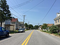
Union Bridge is a town in Carroll County, Maryland, United States. The population was 936 at the 2020 census.

<span class="mw-page-title-main">Charlestown, Maryland</span> Town in Maryland, United States

Charlestown is a town in Cecil County, Maryland, United States. The population was 1,183 at the 2010 census.

<span class="mw-page-title-main">Eldorado, Maryland</span> Town in Maryland, United States

EldoradoEL-də-RAY-doh is a town in Dorchester County, Maryland, United States. The population was 45 at the 2020 census, making it the second smallest town in Maryland.

<span class="mw-page-title-main">Kitzmiller, Maryland</span> Town in Maryland, United States

Kitzmiller is a town in Garrett County, Maryland, United States. The population was 321 at the 2010 census.

<span class="mw-page-title-main">Loch Lynn Heights, Maryland</span> Town in Maryland, United States

Loch Lynn Heights is a town in Garrett County, Maryland, United States. The population was 493 at the 2020 census.

<span class="mw-page-title-main">Pittsville, Maryland</span> Town in Maryland, United States

Pittsville is a town in Wicomico County, Maryland, United States. The population was 1,417 at the 2010 census. It is included in the Salisbury, Maryland-Delaware Metropolitan Statistical Area.

<span class="mw-page-title-main">Sharptown, Maryland</span> Town in Maryland, United States

Sharptown is a town in Wicomico County, Maryland, United States. The population was 651 at the 2010 census. It is included in the Salisbury, Maryland-Delaware Metropolitan Statistical Area.

<span class="mw-page-title-main">Hollywood, South Carolina</span> Town in South Carolina, United States

Hollywood is a town in Charleston County, South Carolina, United States. The population was 4,714 at the 2010 census, up from 3,946 in 2000. Hollywood is part of the Charleston, South Carolina metropolitan area and the Charleston-North Charleston Urbanized Area.

<span class="mw-page-title-main">Pax, West Virginia</span> Town in West Virginia, United States

Pax is a town in Fayette County, West Virginia, United States. The current mayor of Pax is William F. Hughes. The population was 167 at the 2010 census.

<span class="mw-page-title-main">Reedy, West Virginia</span> Town in West Virginia, United States

Reedy is a town in Roane County, West Virginia, United States. The population was 152 at the 2020 census.

<span class="mw-page-title-main">Pine Grove, West Virginia</span> Town in West Virginia, United States

Pine Grove is a town in Wetzel County, West Virginia, United States. The population was 363 at the 2020 census. The community was named for a grove of pine trees near the original town site.

<span class="mw-page-title-main">North Hills, West Virginia</span> Town in West Virginia, United States

North Hills is a town in Wood County, West Virginia, United States. It is a suburb of Parkersburg. The population was 837 at the 2020 census. North Hills was incorporated on February 15, 1979.

<span class="mw-page-title-main">Hampstead, Maryland</span> Town in Maryland, United States

Hampstead is a town in Carroll County in the U.S. state of Maryland. The population was 6,323 at the 2010 census.

References

  1. "2020 U.S. Gazetteer Files". United States Census Bureau. Retrieved April 26, 2022.
  2. "Maryland Manual". Marydel Maryland. Retrieved October 8, 2015.
  3. "Marydel, Maryland (town)". Geographic Names Information System . United States Geological Survey, United States Department of the Interior.
  4. "US Gazetteer files: 2010, 2000, and 1990". United States Census Bureau. February 12, 2011. Retrieved April 23, 2011.
  5. "US Gazetteer files 2010". United States Census Bureau. Archived from the original on January 25, 2012. Retrieved January 25, 2013.
  6. Bock, James (August 31, 1996). "Guatemalans seek better life on Shore Immigrants: The detainment of 107 suspected illegal immigrants has shaken the tranquil lives of Latino residents at a Caroline Co. trailer park". The Baltimore Sun . Retrieved April 6, 2017.
  7. Owens, Clay (August 20, 2007). "Rev. LaBarge to leave Marydel charge". The Star Democrat . Easton, MD. Retrieved April 6, 2017.
  8. "Census of Population and Housing". Census.gov. Retrieved June 4, 2015.
  9. "U.S. Census website". United States Census Bureau . Retrieved January 25, 2013.
  10. "U.S. Census website". United States Census Bureau . Retrieved January 31, 2008.