
Dallas is a city in the U.S. state of Texas and the largest city in and seat of Dallas County, with portions extending into Collin, Denton, Kaufman and Rockwall counties. With an estimated 2019 population of 1,343,573, it is the ninth most-populous city in the U.S. and the third-largest in Texas after San Antonio and Houston. Located in North Texas, the city of Dallas is the main core of the largest metropolitan area in the Southern United States and the largest inland metropolitan area in the U.S. that lacks any navigable link to the sea. It is the most populous city in the Dallas–Fort Worth metroplex, the fourth-largest metropolitan area in the country at 7.5 million people.

Farmers Branch, officially the City of Farmers Branch, is a city in Dallas County, Texas, United States. It is an inner-ring suburb of Dallas and is part of the Dallas–Fort Worth metroplex. Its population was 28,616 at the 2010 census.
Richardson is a city in Dallas and Collin counties in the U.S. state of Texas. As of the 2019 American Community Survey, the city had a total population of 121,323. Richardson is an inner suburb of Dallas. It is home to the University of Texas at Dallas and the Telecom Corridor, with a high concentration of telecommunications companies. More than 5,000 businesses have operations within Richardson's 28 square miles (73 km2), including many of the world's largest telecommunications and networking companies, such as AT&T, Verizon, Cisco Systems, Samsung, ZTE, MetroPCS, Texas Instruments, Qorvo, and Fujitsu. Richardson's largest employment base is provided by the insurance industry, with Blue Cross and Blue Shield of Texas's headquarters, a regional hub for GEICO, regional offices for United Healthcare, and one of State Farm Insurance's three national regional hubs located in the community.

Grapevine is a city and suburb of Dallas and Fort Worth located in northeast Tarrant County, Texas, United States, with minor portions extending into Dallas County and Denton County. The city is located in the Mid-Cities suburban region between Dallas and Fort Worth and includes a larger portion of Dallas/Fort Worth International Airport than other cities.
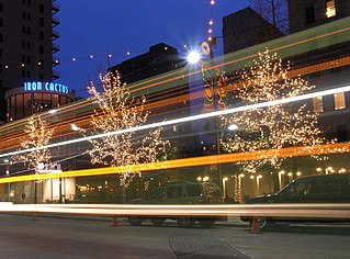
The Main Street District of downtown Dallas, Texas runs along Main Street and is bounded by Elm Street one block north, Commerce St. one block south, N. Lamar St. to the west, and US 75/I-45 (I-345) elevated highway to the east. The district is the spine of downtown Dallas, and connects many of the adjoining business and entertainment districts. It does not include Dealey Plaza or the John Fitzgerald Kennedy Memorial which are a few blocks west in the West End Historic District.

The West End Historic District of Dallas, Texas, is a historic district that includes a 67.5-acre (27.3 ha) area in northwest downtown, generally north of Commerce, east of I-35E, west of Lamar and south of Woodall Rodgers Freeway. It is south of Victory Park, west of the Arts, City Center, and Main Street districts, and north of the Government and Reunion districts. A portion of the district is listed on the U.S. National Register of Historic Places as Westend Historic District. A smaller area is also a Dallas Landmark District. The far western part of the district belongs to the Dealey Plaza Historic District, a National Historic Landmark around structures and memorials associated with the Assassination of John F. Kennedy.

The Cedars is a district in south Dallas Texas (USA). It is adjacent to and south of downtown and Interstate 30, east of Austin Street, north of Corinth Street, and west of the 75 & 345 Overpasses just east of South Good Latimer Expy.

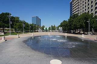
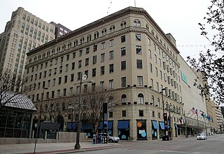
The Arts District is a performing and visual arts district in downtown Dallas, Texas.

The Reunion district of downtown Dallas, Texas (USA) is an area in western downtown anchored by the Hyatt Regency Dallas and Reunion Tower. The name "Reunion" originates from the mid-nineteenth century commune, La Reunion.

The Farmers Market District is an area in southeastern downtown Dallas, Texas (USA). It lies south of the Main Street District, north of the Cedars, west of Deep Ellum, northeast of the Convention Center District, and southeast of the Government District.
Victory Park is a master planned development northwest of downtown Dallas, Texas (USA) and north of Spur 366. It is along Interstate 35E, part of the Stemmons Corridor and Uptown.
Bryan Place is a neighborhood in Old East Dallas, Texas (USA). It is east of the Arts District of downtown and the State Thomas neighborhood, north of Deep Ellum, south of Cityplace and west of Munger Place. Its boundaries are generally considered to be US-75 North Central Expressway on the west, Ross Avenue on the (north)west, N. Washington Street on the (north)east, and Live Oak Avenue on the (south)east.

The Convention Center District is an area in southern downtown Dallas, Texas (USA). It lies south of the Government District, north of the Cedars, west of the Farmers Market District, and east of the Reunion District.Visitdallas is contracted by the City to attract conventions although an audit released in January 2019 cast doubts on its effectiveness.
The City Center District is an area in north-central downtown Dallas, Texas (USA). It lies south of the Arts District, north of the Main Street District, northwest of Deep Ellum, southwest of Bryan Place and east of the West End Historic District. The district contains a large concentration of downtown commercial space which prior to 1950 had been concentrated along Main Street. The district also contains remnants of Theatre Row, the historical entertainment area along Elm Street which contained theatres such as the Majestic Theatre.
Exposition Park is a neighborhood in south Dallas, Texas (USA). Centered along tree-lined Exposition Avenue, the small enclave stretches from the eastern edge of Deep Ellum to the entrance of Fair Park. The area includes Exposition Plaza, a one acre special use park established in 1984 that features an amphitheater and sculpture areas.
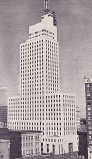
The Mercantile National Bank Building is a 31-story, 159.4 m (523 ft) skyscraper at 1800 Main Street in the Main Street district of downtown Dallas, Texas. It is the former home of the Mercantile National Bank, which later became MCorp Bank. The design of the skyscraper features Moderne styling from the Art Deco era and was designed by Walter W. Ahlschlager. The building has a series of setbacks that is crowned by an ornamental four-sided clock along with a decorative weather spire. The Merc was the main element of a four-building complex that eventually spanned a full city block.

The Kay Bailey Hutchison Convention Center (KBHCCD) is a convention center in the Convention Center District of downtown Dallas, Texas.
The Titche–Goettinger Building is one of Dallas' original broad-front department stores located along St. Paul Street between Main and Elm Street in downtown Dallas, Texas (USA). The structure currently houses apartments, retail space, and the Universities Center at Dallas. It is listed on the National Register of Historic Places both individually and as a contributing property in the Dallas Downtown Historic District and is a Dallas Landmark as part of the Harwood Street Historic District. It is also located across the street from Main Street Garden Park.

Almeda is an area located along Texas State Highway 288 and the Missouri Pacific Railroad in Southwest Houston, Texas, United States that used to be a distinct unincorporated community in Harris County. Almeda is 11 miles (18 km) from Downtown Houston.

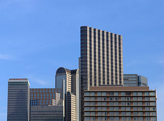
Downtown Dallas is the central business district (CBD) of Dallas, Texas, USA, located in the geographic center of the city. The area termed "Downtown" has traditionally been defined as bounded by the downtown freeway loop, bounded on the east by I-345 (although known and signed as the northern terminus of I-45 and the southern terminus of US 75, on the west by I-35E, on the south by I-30, and on the north by Spur 366.


