
Dallas is the most populous city in the Dallas–Fort Worth metroplex, the fourth-largest metropolitan area in the United States at 7.5 million people. It is the largest city in and seat of Dallas County in the U.S. state of Texas with portions extending into Collin, Denton, Kaufman and Rockwall counties. With a 2020 census population of 1,304,379, it is the ninth most-populous city in the U.S. and the third-largest in Texas after Houston and San Antonio. Located in the North Texas region, the city of Dallas is the main core of the largest metropolitan area in the southern United States and the largest inland metropolitan area in the U.S. that lacks any navigable link to the sea.

Addison is an incorporated town in Dallas County, Texas, in the United States. Addison is situated to the immediate north of the city of Dallas. The town's population was 13,056 at the 2010 census. Addison and Flower Mound were the only two Texas municipalities labeled "towns" with a population greater than 10,000 in the 2010 census; since then the municipalities of Prosper and Trophy Club, also identifying as towns, have also exceeded 10,000 in population estimates. Addison is best known within the Dallas–Fort Worth–Arlington metroplex region for its abundance of restaurants and nightlife.

Balch Springs is a city in Dallas County, Texas, United States. It is an inner-ring suburb of Dallas and part of the Dallas–Fort Worth metroplex. The population was 23,728 at the 2010 census, and 25,007 at 2019's census estimates.
Duncanville is a city in southwest Dallas County, Texas, in the United States. Duncanville's population was 40,706 at the 2020 census. The city is part of the Best Southwest area, which includes Duncanville, Cedar Hill, DeSoto, and Lancaster.

Farmers Branch, officially the City of Farmers Branch, is a city in Dallas County, Texas, United States. It is an inner-ring suburb of Dallas and is part of the Dallas–Fort Worth metroplex. Its population was 28,616 at the 2010 census.
The Main Street District of downtown Dallas, Texas runs along Main Street and is bounded by Elm Street one block north, Commerce St. one block south, N. Lamar St. to the west, and US 75/I-45 (I-345) elevated highway to the east. The district is the spine of downtown Dallas, and connects many of the adjoining business and entertainment districts. It does not include Dealey Plaza or the John Fitzgerald Kennedy Memorial which are a few blocks west in the West End Historic District.

The West End Historic District of Dallas, Texas, is a historic district that includes a 67.5-acre (27.3 ha) area in northwest downtown, generally north of Commerce, east of I-35E, west of Lamar and south of Woodall Rodgers Freeway. It is south of Victory Park, west of the Arts, City Center, and Main Street districts, and north of the Government and Reunion districts. A portion of the district is listed on the U.S. National Register of Historic Places as Westend Historic District. A smaller area is also a Dallas Landmark District. The far western part of the district belongs to the Dealey Plaza Historic District, a National Historic Landmark around structures and memorials associated with the Assassination of John F. Kennedy.

The Cedars is a district in south Dallas Texas (U.S.). It is adjacent to and south of downtown and Interstate 30, east of Austin Street, north of Corinth Street, and west of the 75 & 345 Overpasses just east of South Good Latimer Expy.

The Arts District is a performing and visual arts district in downtown Dallas, Texas.

The Reunion district of downtown Dallas, Texas (USA) is an area in western downtown anchored by the Hyatt Regency Dallas and Reunion Tower. The name "Reunion" originates from the mid-nineteenth century commune, La Reunion.

The Farmers Market District is an area in southeastern downtown Dallas, Texas (USA). It lies south of the Main Street District, north of the Cedars, west of Deep Ellum, northeast of the Convention Center District, and southeast of the Government District.
Victory Park is a master planned development northwest of downtown Dallas, Texas (USA) and north of Spur 366. It is along Interstate 35E, part of the Stemmons Corridor and Uptown.
Bryan Place is a neighborhood in Old East Dallas, Texas (USA). It is east of the Arts District of downtown and the State Thomas neighborhood, north of Deep Ellum, south of Cityplace and west of Munger Place. Its boundaries are generally considered to be US-75 North Central Expressway on the west, Ross Avenue on the (north)west, N. Washington Street on the (north)east, and Live Oak Avenue on the (south)east.

The Government District is an area in south-central downtown Dallas, Texas (USA). It lies south of the Main Street District, southeast of the West End Historic District, north of the Convention Center District, west of the Farmers Market District, and east of the Reunion District.
The City Center District is an area in north-central downtown Dallas, Texas (USA). It lies south of the Arts District, north of the Main Street District, northwest of Deep Ellum, southwest of Bryan Place and east of the West End Historic District. The district contains a large concentration of downtown commercial space which prior to 1950 had been concentrated along Main Street. The district also contains remnants of Theatre Row, the historical entertainment area along Elm Street which contained theatres such as the Majestic Theatre.
This article is about education in Dallas, Texas (USA).
Exposition Park is a neighborhood in south Dallas, Texas (USA). Centered along tree-lined Exposition Avenue, the small enclave stretches from the eastern edge of Deep Ellum to the entrance of Fair Park. The area includes Exposition Plaza, a one acre special use park established in 1984 that features an amphitheater and sculpture areas.

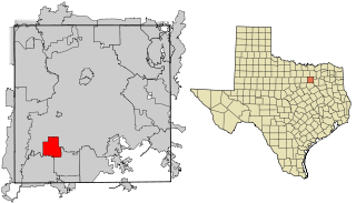
Cedar Hill is a city in Dallas and Ellis counties in the U.S. state of Texas. It is located approximately 16 miles (26 km) southwest of downtown Dallas and is situated along the eastern shore of Joe Pool Lake and Cedar Hill State Park. Per the 2020 United States census, the population was 49,148. Cedar Hill is a suburb of the city of Dallas and is part of the Best Southwest area, which includes the nearby cities of DeSoto, Duncanville, and Lancaster.
North Dallas is an area of numerous communities and neighborhoods in Dallas, Texas. The phrase "North Dallas" is also sometimes used to include any suburb or exurb north of Dallas proper within the metropolitan area. The majority of North Dallas is located in Dallas County, while a small portion is located in Collin and Denton Counties. North Dallas generally includes areas of Dallas north of Northwest Highway, along with Lake Highlands and areas of Dallas north of IH-635 known as Far North Dallas. The area has strong social and economic ties to the Dallas enclave of Park Cities, and two inner suburbs of Dallas, Richardson and Addison. It is the wealthiest part of Dallas, but has its adjacent, less resourced areas as well.

Downtown Dallas is the central business district (CBD) of Dallas, Texas, United States, located in the geographic center of the city. It is the second-largest business district in the state of Texas. The area termed "Downtown" has traditionally been defined as bounded by the downtown freeway loop, bounded on the east by I-45 (although known and signed as the northern terminus of I-45 and the southern terminus of US 75, on the west by I-35E, on the south by I-30, and on the north by Woodall Rodgers Freeway.


