
Oak Lawn is a neighborhood in Dallas, Texas, defined in Dallas City Ordinance 21859 as Planned Development District No. 193, the Oak Lawn Special Purpose District. The unofficial boundaries are Turtle Creek Boulevard, Central Expressway, the City of Highland Park, Inwood Road, and Harry Hines Boulevard. It is over 12 square miles (31 km2) in area. Officially it is bounded by the City of Highland Park, the North Central Expressway, Stemmons Freeway, Woodall Rodgers Freeway, and other roads. The district is within the boundary defined by the City of Dallas law, excluding any existing planned development districts within.
The Main Street District of downtown Dallas, Texas runs along Main Street and is bounded by Elm Street one block north, Commerce St. one block south, N. Lamar St. to the west, and US 75/I-45 (I-345) elevated highway to the east. The district is the spine of downtown Dallas, and connects many of the adjoining business and entertainment districts. It does not include Dealey Plaza or the John Fitzgerald Kennedy Memorial which are a few blocks west in the West End Historic District.

The West End Historic District of Dallas, Texas, is a historic district that includes a 67.5-acre (27.3 ha) area in northwest downtown, generally north of Commerce, east of I-35E, west of Lamar and south of the Woodall Rodgers Freeway. It is south of Victory Park, west of the Arts, City Center, and Main Street districts, and north of the Government and Reunion districts. A portion of the district is listed on the U.S. National Register of Historic Places as Westend Historic District. A smaller area is also a Dallas Landmark District. The far western part of the district belongs to the Dealey Plaza Historic District, a National Historic Landmark around structures and memorials associated with the assassination of John F. Kennedy.

The Cedars is a district in Dallas, Texas (U.S.). It is adjacent to and south of downtown and Interstate 30, east of Austin Street, north of Corinth Street, and west of the 75 & 345 Overpasses just east of South Good Latimer Expy.

The Arts District is a performing and visual arts district in downtown Dallas, Texas.

The Reunion district of downtown Dallas, Texas (USA) is an area in western downtown anchored by the Hyatt Regency Dallas and Reunion Tower. The name "Reunion" originates from the mid-nineteenth century commune and current ghost town, La Reunion.

The Farmers Market District is an area in southeastern downtown Dallas, Texas (USA). It lies south of the Main Street District, north of the Cedars, west of Deep Ellum, northeast of the Convention Center District, and southeast of the Government District.

Lake Highlands is a neighborhood constituting most of Northeast Dallas. The neighborhood is a collection of dozens of subdivisions served by Richardson ISD and Dallas ISD public schools, as well as an array of private schools.

Victory Park is a master planned development northwest of downtown Dallas, Texas (USA) and north of Spur 366. It is along Interstate 35E, part of the Stemmons Corridor and Uptown.

Cityplace is a TIF District and neighborhood in Old East Dallas, Texas (USA) - near the Uptown area of Dallas, adjacent to the intersection of Central Expressway and Haskell Avenue/Blackburn Street. East of Central Expressway, the neighborhood includes the tree-lined Haskell boulevard and travels past the 42-story Tower at Cityplace. At 42-stories, it is the tallest building in Dallas outside downtown. Also on the east is the newer Cityville high-end apartment complex. The west side Cityplace includes the new-urbanist West Village and the northern end of the Uptown neighborhood.

Bryan Place is a neighborhood in Old East Dallas, Texas (USA). It is east of the Arts District of downtown and the State Thomas neighborhood, north of Deep Ellum, south of Cityplace and west of Munger Place. Its boundaries are generally considered to be US-75 North Central Expressway on the west, Ross Avenue on the (north)west, N. Washington Street on the (north)east, and Live Oak Avenue on the (south)east.

The Government District is an area in south-central downtown Dallas, Texas (USA). It lies south of the Main Street District, southeast of the West End Historic District, north of the Convention Center District, west of the Farmers Market District, and east of the Reunion District.

The Convention Center District is an area in southern downtown Dallas, Texas (USA). It lies south of the Government District, north of the Cedars, west of the Farmers Market District, and east of the Reunion District. Visitdallas is contracted by the City to attract conventions, although an audit released in January 2019 cast doubts on its effectiveness.

North Dallas High School is a public secondary school located in the Oak Lawn area of Dallas, Texas, United States. It enrolls students in grades 9-12 and is a part of the Dallas Independent School District. As of 2017, the principal administrator is Katherine Eska.

Knox / Henderson is a neighborhood in Dallas, Texas (USA). It is north of the Uptown neighborhood and east and south of the enclave of Highland Park. It is centered on Knox Street, Henderson Avenue, McKinney Avenue, and Cole Avenue. The area is home to many bars, restaurants, and shops. The Katy Trail also runs through the neighborhood.

Perry Heights is a historical neighborhood in the Oak Lawn area of Dallas, Texas (USA). As one of the last remaining single-family neighborhoods in the Dallas uptown area, Perry Heights consists of three by three streets of residential real estate with neighborhood restaurants and bars within walking distance. The neighborhood consists of 115 single-family homes. At last count, there are 69 homes remaining that were built in the 1920s, 10 were built in the 1930s, 8 in the 1940s, 10 in the 1950s, and the rest after the 1960s. Perry Heights was developed in 1922 by wealthy real estate investor and car dealership owner, E. Gordon Perry. It is bounded by Hawthorne Avenue on the northwest, Rawlins Street on the northeast, Wycliff Avenue on the southeast, and Vandelia Street on the southwest.
Parkdale Heights is a neighborhood in east Dallas, Texas (USA). The official name for the neighborhood is Parkdale, the neighborhood was established in 1926. It is bounded on the west by railroad tracks, on the northwest by railroad tracks, on the north by Military Parkway, on the east by Bisbee Drive and on the south by Scyene Road.

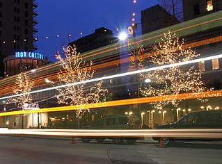
Uptown is a PID and a dense neighborhood in Dallas, Texas. Uptown is north of and adjacent to downtown Dallas, and is bordered by US 75 on the east, N Haskell Avenue on the northeast, the Katy Trail on the northwest, Bookhout Street and Cedar Springs Road on the west, N Akard Street on the southwest and Spur 366 on the south.
North Dallas is an area of numerous communities and neighborhoods in Dallas, Texas. The phrase "North Dallas" is also sometimes used to include any suburb or exurb north of Dallas proper within the metropolitan area. The majority of North Dallas is located in Dallas County, while a small portion is located in Collin and Denton counties. North Dallas generally includes areas of Dallas north of Northwest Highway, along with Lake Highlands and areas of Dallas north of IH-635 known as Far North Dallas. The area has strong social and economic ties to the Dallas enclave of Park Cities, and two inner suburbs of Dallas, Richardson and Addison.

Downtown Dallas is the central business district (CBD) of Dallas, Texas, United States, located in the geographic center of the city. It is the second-largest business district in the state of Texas. The area termed "Downtown" has traditionally been defined as bounded by the downtown freeway loop, bounded on the east by I-345 (although known and signed as the northern terminus of I-45 and the southern terminus of US 75, on the west by I-35E, on the south by I-30, and on the north by Woodall Rodgers Freeway.


