Hendler Creamery

Last updated
Hendler Creamery
Hendler Creamery, 1100 E. Baltimore St., Baltimore City, Maryland.JPG
Hendler Creamery in 2011
Baltimore osm-mapnik location map.png
Red pog.svg
USA Maryland location map.svg
Red pog.svg
Usa edcp location map.svg
Red pog.svg
Location1100 E. Baltimore St. & 1107 E. Fayette St., Baltimore, Maryland
Coordinates 39°17′28″N76°36′8″W / 39.29111°N 76.60222°W / 39.29111; -76.60222 Coordinates: 39°17′28″N76°36′8″W / 39.29111°N 76.60222°W / 39.29111; -76.60222
Area1.5 acres (0.61 ha)
Built1892
Architect Jackson C. Gott
Architectural styleRomanesque, Early Commercial
NRHP reference No. 07001032 [1]
Added to NRHPDecember 20, 2007

Hendler Creamery is a historic industrial complex in Jonestown, Baltimore, Maryland. Since it spans an entire block it has addresses at 1100 E. Baltimore St. and 1107 E. Fayette St. "The Hendler Creamery is historically significant for its contribution to the broad patterns of history in three areas of significance: transportation, performing arts, and industry." [2]

Contents

Varying usages

Construction and architect

The Hendler Creamery consists of two adjacent building complexes. The original 59,340-square-foot (5,513 m2) three-story brick Richardsonian Romanesque building was constructed as a cable car powerhouse in 1892, replacing five old houses on the site in the Old Town / Jonestown neighborhood east of the downtown neighborhood and the dividing Jones Falls stream in East Baltimore. [3] This use necessitated massive arched doors and a mezzanine floor. [4] The construction is of red face brick with red mortar joints and Potomac red Seneca stone trim, and contains much architectural detailing. The front on East Baltimore Street includes four large contiguous Romanesque Revival half-round arched openings with four pairs of rectangular window openings directly above these. In reviewing plans for the building, the influential "The Sun" newspaper descriptively wrote at the time of February 1892, that "it would be one of the most prominent structures in that part of the city" and continued, "Economy, durability and simplicity are the controlling motives of the design, and a practical power-house, with a proper regard for architectural proportions and effect, without unnecessary ornamentation, is expected to be the result." [5]

Additions for later owners including Hendler's Creamery for dairy products and their locally famous brand of ice cream, were built in 1915-20 and 1949. It is also connected to a one-story brick building built in the 1960s. The second building complex is a 33,504-square-foot (3,112.6 m2) brick warehouse structure built from 1923 to 1927.

The architect was Jackson C. Gott (1829-1909), a Baltimore-based architect who is survived by eight buildings currently listed on the National Register of Historic Places maintained by the United States Department of the Interior and its National Park Service. [1] In the same year that the Jonestown cable-car powerhouse was built, Gott also designed in the northern area of the expanding city, the currently named Charles Theatre building on North Charles Street by East Lanvale Street (few blocks south of North Avenue, previously named Boundary Avenue as the old northern city limits from 1818 to 1888), also for the B.C.P.R. It too served as a cable-car powerhouse, in this case for the BCPR's 2.2 mile Blue Line, which ran south to north, essentially along Charles Street, from South Street by East Pratt Street on the downtown harbor waterfront and financial district to 25th Street (then named Huntingdon Avenue) in the Peabody Heights (now renamed Charles Village) neighborhood, being recently developed by the 1870s on the north edge of the city. The structure later served for several purposes including a dance hall as the Famous Ballroom through the 20th century until presently renovated into a prominent multi-screen movie theater in the recently renamed Mid-Town Station North neighborhood. In the 1890s, Gott further designed two other well-known extant Baltimore buildings: the additional landmark with a dark gray granite stone central pyramidal tower and the west/south wings facing on Greenmount Avenue and Eager & Forrest Streets for the northern/eastern extensions of the old Maryland Penitentiary, founded 1806, previously facing on East Madison Street, (now renamed the Metropolitan Transition Center in the 2010s) in 1894, and the Southern District Police Station for the Baltimore City Police Department at 28 East Ostend Street (between South Charles and Light Streets) in the old South Baltimore / Federal Hill neighborhood in 1896.

Cable-car powerhouse

As a cable-car powerhouse for the Baltimore City Passenger Railway Company from 1892 to 1898, the building played an important role in Baltimore's transportation history as cable-car mass transit was first developed to replace the horse-car lines operating for half a century since the late 1850s. According to the Maryland Historical Trust, the building powered the run of cable from Gay Street to North Avenue, using two Reynolds compound non-condensing Corliss steam engines, 24" + 38" x 60". These propelled a sheave which pulled a continuous loop of cable and moved the car at a speed of around 11 miles per hour. Just like a subway line today, this line was designated by a color, the Red Line, and ran from East North Avenue, south down North Gay Street, curving around to the east on East Baltimore Street, and then on further east to Bank Street and Patterson Park in East Baltimore's developing Highlandtown neighborhood. The total mileage distance was 10.7.

Electric-powered cars with overhead lines began replacing cable cars on the Red Line on August 30, 1898, as a more economical and faster means of mass transit. Cables were removed immediately, but the expense of extracting the underground pulleys, sheaves and other steel/iron fittings was too much, and in most instances they were just covered over as streets were gradually repaired and resurfaced with bricks, cobblestones / Belgian blocks or later concrete / asphalt. With the switchover, The Baltimore City Passenger Railway Company was absorbed into Baltimore's merged trolley monopoly in the late 1890s with the formation of the United Railways and Electric Company (later the Baltimore Transit Company after a bankruptcy and reorganization in 1935, adding transit diesel powered buses to the extensive streetcar system), and power was generated at the newly constructed pile of the massive huge red brick Pratt Street Power Plant, situated on the waterfront at municipal Pier 4, facing the Northwest Branch of the Patapsco River and its "Basin" (later known as the Inner Harbor). UREC held onto the landmark industrial building with its electric generators connected to great furnaces and boilers for steam power with four parallel smokestacks and conveyor belt system for loading coal ore fuel from moored harbor barges connected to waterfront terminal facilities further south in the Baltimore Harbor of the Baltimore and Ohio Railroad and the Western Maryland Railway trains from the mines in the Appalachian Mountains to the West, for a few decades, using the rear half as a "trouble station" for trolleys and renting out the front to the U.S. Navy (Maryland) Naval Reserves for use as a drill-room.

In all, the two later competing Baltimore cable-car companies (themselves a product of mid and late 19th century mergers and consolidations), the Baltimore Traction Company (BTC) and Baltimore City Passenger Railway (BCPR), built six powerhouses scattered through the city, three each. This was a very significant capital expense for an industrial enterprise that only lasted from 1891 to 1899. Of the three and a half surviving powerhouses, the later Hendler Creamery building on East Baltimore Street between East and Lloyd Streets is the only one listed on the National Register of Historic Places. As mentioned above, another Gott designed powerhouse survives today as the Charles Theatre (BCPR) building, while the third totally extant powerhouse (BTC) lies three blocks south at 1110 East Pratt Street by Central Avenue (formerly Canal Street and before that the Hartford Run stream). The latter was most recently used as the Pratt Street Garage of the Baltimore City Department of Public Works - Solid Waste Division. It is now boarded up and waiting some kind of adaptive re-use. It stretches a full block, between East Pratt and Granby Streets, and is surrounded by Albemarle Square, a 15 block rebuilt and revitalized area that replaced a 1950s era of the high-rise towers of the now dilapidated and crime ridden Flag House Courts public housing projects, with a new surrounding neighborhood of multi-priced townhouse residences renamed Albemarle Square, which resembled the previous 19th and early 20th centuries tightly packed blocks of brick rowhouses of the old original Old Town / Jonestown communities founded in the 1760s. [6]

While not having the architectural flair of Stanford White's nine-story Beaux-Arts Cable Building on lower Broadway in New York City, the Hendler Creamery is one of the absolute gems of the American cable powerhouses that have survived. For the most part these structures evidenced utilitarian, warehouse style construction, which can be seen clearly in the still extant LaSalle Street Cable Car Powerhouse in Chicago, Illinois.

The only other architecturally significant Baltimore cable-car powerhouse, the former Baltimore Traction Company's Druid Hill Avenue powerhouse and car barn, south of Druid Hill Park in the northwest city, lost half of its structure in 2005 in a spectacular 5 - alarm blaze. It is a massive Victorian and Romanesque-style red brick-and-stone trim structure. [7] The Epworth Powerhouse (BTC) on Mosher Street in West Baltimore had been torn down years before (see drawing below in gallery). It is a lesson in a site's metamorphoses: going from a church to a powerhouse to a dry cleaning plant, and finally, after demolition, to a high-rise apartment building standing today. The last powerhouse (BCPR) on South Eutaw Street, south of West Baltimore Street, succumbed long ago to the pressures of razing and urban redevelopment.

Yiddish theatre

After the replacement of the cable car by electric trolleys, the Hendler Creamery was then converted into a performance space by Baltimore-born James Lawrence Kernan (1838-1912). He was a theater manager, entrepreneur, and philanthropist, who earlier in his life had fought for the Confederates, been captured and held as a prisoner till the war's end at the brutal Point Lookout Prisoner-of-War Camp at the confluence of the Chesapeake Bay and Potomac River. Returning to civilian life, among other ventures, he started a combination hotel and German Rathskeller and founded a hospital, which survives today as the University of Maryland Rehabilitation & Orthopaedic Institute.

Under Kernan's ownership, a second floor, containing an auditorium and dressing rooms, was installed above the first-floor engine room. He named it the Convention Hall Theater. It operated primarily as a Yiddish theater from 1903 to 1912, serving the largely Jewish immigrant population. Some of the city's earliest motion pictures were also shown here by Kernan. Yiddish theater was first performed in Baltimore in the mid-1880s at Concordia Hall, an aristocratic club of Baltimore German Jews. It burnt down in 1891.

The building's conversion to a theater links it to Baltimore's early-20th century performing arts history, which includes melodrama, movies, opera, vaudeville, as well as the Yiddish theater.

Hendler Ice Cream Company

The building's most important and longest historical legacy came when it was purchased by the Hendler Ice Cream Company in 1912 for $40,000 [8] and converted to the country's first fully automated ice cream factory. [2]

Besides producing one of Baltimore's favorite brands of ice cream, it played a major role in the development of the nation's ice cream business. Many important pioneering industry innovations were developed over the next 50 years in this building, including new kinds of packaging; the blade sharpener, which produced smoother ice cream; and fast freezing, which allowed ice cream to be frozen with a liquid cream texture. The adjoining building at 1107 East Fayette Street, built in the 1920s as part of the Hendler Creamery complex, is also significant, notably in the creation of one of the nation's first ice cream delivery systems by refrigerated truck. As the Maryland Historical Society noted in a blog posting, The Velvet Kind: The Sweet Story of Hendlers Creamery, "The ice cream was virtually everywhere in Maryland, as it was distributed to over 400 stores at the company’s peak, which kept the production lines humming. The factory ran six days a week with vanilla ice cream being made almost everyday. Vanilla, chocolate, and strawberry were production mainstays, but the creamery dabbled in more exotic flavors as well. Hutzler's department store sold several varieties, including ginger and peppermint. For the Southern Hotel, [9] [10] Hendlers supplied a tomato sorbet which was served as a side dish rather than dessert. The eggnog ice cream was produced each year at Christmas time. Hendler made with real rum, was a major hit. The factory also cranked out other holiday-themed products, such as an Independence Day treat made with vanilla, strawberry, and blueberry ice creams and a Mother’s Day cake topped with a silk screen of James McNeill Whistler’s portrait of his mother." [11]

The creamery closed in the 1970s. The nearby Jewish Museum of Maryland has an extensive archive of Hendler Company and family memorabilia. [12]

Historic preservation designation

The Hendler Creamery was listed on the National Register of Historic Places in 2007. [1]

Reuse

Following a fourth incarnation as a warehouse and city social services agency, the Hendler Creamery buildings are, as of the spring of 2014, being planned for refurbishment. The Commercial Group, a Maryland-based real estate and construction company, bought the building in 2012 for $1.08 million, and is planning a $51 million adaptive re-use, featuring 276 units, along with up to 11,000 sq ft of retail. The project includes exclusive amenities such as multiple outdoor courtyards, a pool deck overlooking the Baltimore skyline, basketball courts, and a yoga studio. Kirby Fowler, president of Downtown Partnership of Baltimore Inc., said redevelopment of the Hendler building would be the next chapter in a decade-long revival for Jonestown. “When you think about what that area used to be like 12 years ago, we’ve gone lightyears toward improvement,” Fowler said. “Albermarle Square [about four blocks away] is this incredibly progressive mixed-income project that came as the result of some HUD money and federal support, and it’s really helped expand Little Italy and Fells Point further north. There’s already progress heading in that direction, and this just continues that.” [13]

Baltimore City officials have said that they view this location—two blocks east of the iconic Shot Tower, seven blocks west of the bustling campus of The Johns Hopkins Hospital and nine blocks north of the contemporary mixed-use development project Harbor East—as critical to attractively tying together the Hopkins medical facilities and Downtown Baltimore. [14]

On March 14, 2023, Baltimore's Commission for Historical and Architectural Preservation (CHAP) declined to block the demolition of the already partially demolished historic property. Plans are for the development of a community green space in its place. [15]

Related Research Articles

<span class="mw-page-title-main">Enoch Pratt Free Library</span> Building

The Enoch Pratt Free Library is the free public library system of Baltimore, Maryland. Its Central Library and office headquarters are located on 400 Cathedral Street (southbound) and occupy the northeastern three quarters of a city block bounded by West Franklin Street to the north, Cathedral Street to the east, West Mulberry Street to the south, and Park Avenue (northbound) to the west. Located on historic Cathedral Hill, north of downtown, the library is also in the Mount Vernon-Belvedere-Mount Royal neighborhood and cultural and historic district.

<span class="mw-page-title-main">Hampden, Baltimore</span> Neighborhood of Baltimore in Maryland, United States

Hampden is a neighborhood located in northern Baltimore, Maryland, United States. Roughly triangular in shape, it is bounded to the east by the neighborhood Wyman Park, to the north by Roland Park at 40th and 41st Street, to the west by the Jones Falls Expressway, and to the south by the neighborhood Remington. The Homewood campus of the Johns Hopkins University is a short distance to the east.

<span class="mw-page-title-main">Mount Vernon, Baltimore</span> Neighborhood in Baltimore, Maryland, United States

Mount Vernon is a neighborhood of Baltimore, Maryland, located immediately north of the city's downtown district. Designated a city Cultural District, it is one of the oldest neighborhoods originally home to the city's wealthiest and most fashionable families. The name derives from Mount Vernon, the home of George Washington, given the original Washington Monument, a massive pillar commenced in 1815 to commemorate the first president of the United States, is the defining feature of the neighborhood.

<span class="mw-page-title-main">Piedmont Avenue (Oakland, California)</span> Neighborhood of Oakland in Alameda, California, United States

The Piedmont Avenue neighborhood is a residential and commercial district in the North Oakland region of Oakland, California. It is named for Piedmont Avenue, a commercial street known for dining and retail. The neighborhood is roughly bounded by Temescal and Broadway on the west, Oakland Avenue and the City of Piedmont on the east, the Mountain View Cemetery on the north, and the MacArthur Freeway section of Interstate 580 on the south.

<span class="mw-page-title-main">Power Plant Live!</span> Collection of businesses in the Inner Harbor section of Baltimore, Maryland, US

Power Plant Live! is a collection of bars, restaurants and other businesses in the Inner Harbor section of downtown Baltimore, Maryland. It was developed by The Cordish Companies and opened in phases during 2001, 2002, and 2003. The entertainment complex gets its name from the nearby "Power Plant" building, three blocks south on municipal Pier 4 on East Pratt Street facing the Inner Harbor, which was also later re-developed by Cordish.

<span class="mw-page-title-main">Reservoir Hill, Baltimore</span> Historic house in Maryland, United States

Reservoir Hill, also known as Whitelock, is a neighborhood in the city of Baltimore, Maryland, United States. It is located south of Druid Hill Park, north of Bolton Hill, east of Penn-North, and west of Jones Falls. It is bounded by Druid Park Lake Drive, the Jones Falls Expressway, North Avenue, and McCulloh Street. It is contained in the 21217 ZIP code.

<span class="mw-page-title-main">McElderry Park, Baltimore</span> Neighborhood of Baltimore in Maryland, United States

McElderry Park is a neighborhood in the northern part of the southeastern district of the City of Baltimore. Its boundaries are marked by East Fayette Street, East Monument Street, Linwood Avenue, and Patterson Park Avenue. South of McElderry Park is the neighborhood of Patterson Park; Butchers Hill is to the southwest. Ellwood Park is located to the east, and the campus of The Johns Hopkins Hospital to the west. To its north is the neighborhood of Madison-East End.

<span class="mw-page-title-main">Union Square, Baltimore</span> United States historic place

Union Square is a neighborhood located in the Sowebo area of Baltimore. It dates to the 1830s and includes a historic district of houses and commerce buildings.

<span class="mw-page-title-main">Charles Street (Baltimore)</span> State Highway in Maryland, US

Charles Street, known for most of its route as Maryland Route 139, runs through Baltimore City and through the Towson area of Baltimore County. On the north end it terminates at an intersection with Bellona Avenue near Interstate 695 (I-695) and at the south end it terminates in Federal Hill in Baltimore. Charles Street is one of the major routes through the city of Baltimore, and is a major public transportation corridor. For the one-way portions of Charles Street, the street is functionally complemented by the parallel St. Paul Street, Maryland Avenue, Cathedral Street, and Liberty Street.

<span class="mw-page-title-main">Jonestown, Baltimore</span> Neighborhood of Baltimore in Maryland, United States

Jonestown is a neighborhood in the southeastern district of Baltimore. Its boundaries are the north side of Pratt Street, the west side of Central Avenue, the east side of Fallsway, and the south side of Orleans Street. The neighborhood lies north of the Little Italy, south of the Old Town, west of the Washington Hill, and east of the Downtown Baltimore neighborhoods. The southern terminus of the Jones Falls Expressway is located here.

<span class="mw-page-title-main">First Unitarian Church (Baltimore, Maryland)</span> United States historic place

The First Unitarian Church is a historic church and congregation at 12 West Franklin Street in Mount Vernon, Baltimore, Maryland. Dedicated in 1818, it was the first building erected for Unitarians in the United States. The church is a domed cube with a stucco exterior. The church, originally called the "First Independent Church of Baltimore", is the oldest building continuously used by a Unitarian congregation. The name was changed in 1935 to "The First Unitarian Church of Baltimore " following the merger with the former Second Universalist Church at East Lanvale Street and Guilford Avenue in midtown Baltimore. The American Unitarian Association and the Universalist Church of America (established 1866) representing the two strains of Unitarian Universalism beliefs and philosophies merged as a national denomination named the Unitarian Universalist Association in May 1961.

<span class="mw-page-title-main">First Presbyterian Church and Manse (Baltimore, Maryland)</span> Historic church in Maryland, United States

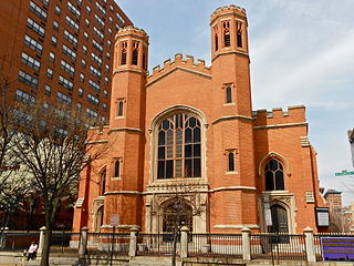
First Presbyterian Church and Manse is a historic Presbyterian church located at West Madison Street and Park Avenue in the Mount Vernon-Belvedere neighborhood of Baltimore, Maryland, United States. The church is a rectangular brick building with a central tower flanked by protruding octagonal turrets at each corner. At the north end of the church is a two-story building appearing to be a transept and sharing a common roof with the church, but is separated from the auditorium by a bearing wall. The manse is a three-story stone-faced building. The church was begun about 1854 by Nathan G. Starkweather and finished by his assistant Edmund G. Lind around 1873. It is a notable example of Gothic Revival architecture and a landmark in the City of Baltimore.

<span class="mw-page-title-main">Franklin Street Presbyterian Church and Parsonage</span> Historic church in Maryland, United States

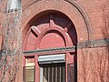
Franklin Street Presbyterian Church and Parsonage is a historic Presbyterian church located at 100 West Franklin Street at Cathedral Street, northwest corner in Baltimore, Maryland, United States. The church is a rectangular Tudor Gothic building dedicated in 1847, with an addition in 1865. The front features two 60 foot flanking octagonal towers are also crenelated and have louvered belfry openings and stained glass Gothic-arched windows. The manse / parsonage at the north end has similar matching walls of brick, heavy Tudor-Gothic window hoods, and battlements atop the roof and was built in 1857.

<span class="mw-page-title-main">Eastern Female High School</span> United States historic place

Eastern Female High School, also known as Public School No. 116, is a historic female high school located on the southeast corner of the 200 block of North Aisquith Street and Orleans Street, in the old Jonestown / Old Town neighborhoods, east of Downtown Baltimore and now adjacent to the recently redeveloped Pleasant View Gardens housing project / neighborhood of Baltimore, Maryland, United States. It was built in 1869-1870 and is typical of the Italian Villa mode of late 19th-century architecture. It was dedicated in a large ceremony with speeches later published in a printed phamplet and attending crowds in early 1870. Old Eastern High is a two-story brick structure that features a square plan, three corner towers, and elaborate bracketing cornices, with a similar wood decorated porch/portico over front entrance on its west side facing Aisquith Street.

James Lawrence Kernan (1838–1912) was a theater manager and philanthropist based in Baltimore, Maryland.

<span class="mw-page-title-main">Baltimore East/South Clifton Park Historic District</span> Historic district in Maryland, United States

Baltimore East/South Clifton Park Historic District is a national historic district in Baltimore, Maryland, United States. It is primarily an urban residential area organized in a gridiron pattern. It comprises approximately 110 whole and partial blocks that formed the historic northeast corner of the City of Baltimore prior to 1888. While rowhouses dominate the urban area, the historic district also contains other property types which contribute to its character including brewing, meat packing, cigar manufacturing, printing, and a tobacco warehouse. The Baltimore Cemetery completes the historic district.

Jackson C. Gott (1829–1909) was an American architect. Gott was born in Baltimore County, practiced in and around Baltimore all his life, and was named a Fellow of the American Institute of Architects in 1889.

Baltimore Heritage is an American nonprofit historic-preservation organization headquartered in Baltimore, Maryland.

<span class="mw-page-title-main">Patterson Park (neighborhood), Baltimore</span> United States historic place

Patterson Park is a neighborhood in Baltimore, Maryland, United States. Named for the 137-acre park that abuts its north and east sides, the neighborhood is in the southeast section of Baltimore city, roughly two miles east of Baltimore's downtown district.

<span class="mw-page-title-main">Midtown-Edmondson, Baltimore</span> Neighborhood of Baltimore in Maryland, United States

Midtown-Edmondson is a mixed-use neighborhood in western Baltimore City developed mostly between the 1880s and the 1910s. The neighborhood is mainly composed of residential rowhouses, with a mixed-used business district along Edmondson Avenue, and industrial warehouses and buildings dotted along the CSX railroads that bound its western edge.

References

  1. 1 2 3 "National Register Information System". National Register of Historic Places . National Park Service. July 9, 2010.
  2. 1 2 Charles Belfoure (January 2007). "National Register of Historic Places Registration: Hendler Creamery" (PDF). Maryland Historical Trust. Retrieved 2016-04-01.
  3. "Maryland Historical Society". Property Address file for 1100-1108 East Baltimore Street. Retrieved 28 March 2014.
  4. The Benjamin Latrobe, Jr. Chapter of The Society for Industrial Archeology (1995). Baltimore: Industrial Gateway on the Chesapeake. Baltimore, MD.: The Baltimore Museum of Industry. p. Page 93.
  5. "Reproduced with permission of the copyright owner. Further reproduction prohibited without permission. City Passenger Railway Power~House". The Baltimore sun. Feb 6, 1892. ProQuest   535399499.
  6. Marc Wouters Architect and Urbanist. "Albemarle Square, Flag House Courts Revitalization" . Retrieved 29 March 2014.
  7. Jacques Kelly and Frederick N. Rasmussen (Jan 15, 2005). "Relic of cable cars is lost". The Baltimore Sun. Retrieved 26 March 2014.
  8. Ascher, Amalie (Jul 26, 1981). "ICE CREAM DAYS: Even Before Albert Hendler Started Working at the Plant He Got a Taste of the Business at Home". The Baltimore Sun.
  9. Updated for 2013. "Old Baltimore Hotels Kilduffs". The Southern Hotel -- 11 Light Street. Retrieved 30 March 2014.
  10. Rasmussen, Frederick N. (June 5, 1999). "Way Back When Changes: Southern Hotel finally to fall -- Hotels have stood at the corner of Light and Redwood streets for more than 200 years. Another is to replace this one". The Baltimore Sun. Retrieved 30 March 2014.
  11. Maryland Historical Society Library Department (July 18, 2013). "The Velvet Kind: The Sweet Story of Hendlers Creamery". underbelly FROM THE DEEPEST CORNERS OF THE MARYLAND HISTORICAL SOCIETY LIBRARY. Retrieved 29 March 2014.
  12. "MS 147 Hendler's Creamery Collection".
  13. Briggs, James (Nov 2, 2012). "Hendler Creamery building in southeast Baltimore sold for $1.08M Apartments planned for building in city's historic Jonestown". Baltimore Business Journal. Retrieved 29 March 2014.
  14. Litten, Kevin. "Kevin Litten". May 23, 2013. The Baltimore Business Journal. Retrieved 25 March 2014.
  15. Gunts, Ed. "Preservation panel declines to block demolition of Baltimore's historic Hendler Creamery". March 17, 2023. Baltimore Fishbowl. Retrieved 20 March 2023.