
Arlington County is a county in the U.S. state of Virginia. The county is located in Northern Virginia on the southwestern bank of the Potomac River directly across from Washington, D.C., the national capital.

Rosslyn is a heavily urbanized unincorporated area in Northern Virginia located in the northeastern corner of Arlington County, Virginia, north of Arlington National Cemetery and directly across the Potomac River from Georgetown and Foggy Bottom in Washington, D.C.

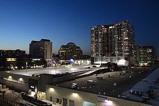
Ballston is a neighborhood in Arlington County, Virginia. Ballston is located at the western end of the Rosslyn-Ballston corridor. It is a major transportation hub and boasts one of the nation's highest concentrations of scientific research institutes and research and development agencies including the Defense Advanced Research Projects Agency-DARPA, the Office of Naval Research, the Advanced Research Institute of Virginia Tech, the Air Force Office of Scientific Research, and associated engineering, management, and public sector consulting firms. Ballston also contains a section known as Virginia Square and sometimes the area is collectively known as Ballston-Virginia Square.

Queen Anne is a neighborhood and geographic feature in Seattle, Washington, United States, located northwest of downtown. Queen Anne covers an area of 7.3 square kilometers (2.8 sq mi), and has a population of about 28,000. It is bordered by Belltown to the south, Lake Union to the east, the Lake Washington Ship Canal to the north and Interbay to the west.

Clarendon is an urbanized, upper-class neighborhood in Arlington County, Virginia, located between the Rosslyn area and the Ballston area. It was named after Edward Hyde, 1st Earl of Clarendon, a leading statesman and historian of the English Civil War. The main thoroughfares are Wilson Boulevard and Clarendon Boulevard.
Pentagon City is an unincorporated neighborhood located in the southeast portion of Arlington County, Virginia, near the Pentagon and Arlington National Cemetery.
The Central Area, commonly called the Central District or The CD, is a mostly residential district in Seattle located east of downtown and First Hill ; west of Madrona, Leschi and Mt. Baker; south of Capitol Hill, and north of Rainier Valley. Historically, the Central District has been one of Seattle's most racially and ethnically diverse neighborhoods, and was once the center of Seattle's black community and a major hub of African-American businesses.
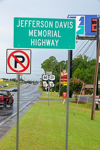
The Jefferson Davis Highway, also known as the Jefferson Davis Memorial Highway, was a transcontinental highway in the United States in the 1910s and 1920s that began in Arlington, Virginia, and extended south and west to San Diego, California; it was named for Jefferson Davis, President of the Confederate States, United States senator, and Secretary of War. Because of unintended conflict between the National Auto Trail movement and the federal government, it is unclear whether it ever really existed in the complete form that its United Daughters of the Confederacy (UDC) founders originally intended.

The Lee Highway was a national auto trail in the United States, connecting New York City and San Francisco, California, via the South and Southwest.

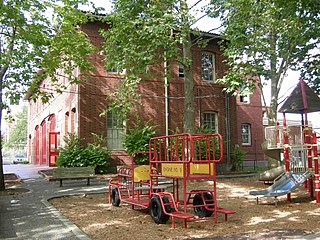
The H-B Woodlawn Secondary Program, commonly referred to as H-B, or HBW, is a democratic alternative all-county public school located in Arlington County, Virginia, based on the liberal educational movements of the 1960s and 1970s. The school, which serves grades 6 through 12, is a part of the Arlington Public Schools district.

The Washington and Old Dominion Railroad Regional Park is a linear regional park in Northern Virginia. The park's primary feature is the Washington and Old Dominion Railroad Trail, an asphalt-surfaced paved rail trail that runs through densely populated urban and suburban communities as well as through rural areas. Most of the trail travels on top of the rail bed of the former Washington and Old Dominion Railroad, which closed in 1968.
Yorktown High School is a public high school located in Arlington County, Virginia. There are around 240 teachers and 2100 students as of 2019. In 2022-23 school year, there were 2,577 students. Yorktown's attendance area makes up the northern third of Arlington County.
Arlington Public Schools is a public school division in Arlington County, Virginia. In 2019, student enrollment was 28,020 students, with students coming from more than 146 countries. In 2015, there were 2,166 teachers. There are 24 elementary schools, 6 middle schools, 4 high schools, 1 secondary institution and 4 other educational programs within the school district.
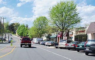
Westover is a neighborhood in Arlington County, Virginia, The neighborhood has been named to the National Register of Historic Places. It is centered on Washington Boulevard between North McKinley Road and North Longfellow Street.

Lyon Village is a neighborhood and urban village in Arlington County, Virginia, along Langston Boulevard. It adjoins Arlington County's government center, and is approximately one mile west of Rosslyn and less than a mile north of Clarendon, of which it is sometimes considered a sub-neighborhood, as is Cherrydale, the mostly residential district immediately west of Lyon Village.
Alexandria, Virginia, an independent city in the Commonwealth of Virginia, is located along the western bank of the Potomac River. The city of approximately 151,000 is about six miles south of downtown Washington, D.C.
Nauck is a neighborhood in the southern part of Arlington County, Virginia, known locally as Green Valley. It is bordered by Four Mile Run and Shirlington to the south, Douglas Park to the west, I-395 to the east, and Columbia Heights and the Army-Navy Country Club to the north. The southeastern corner of the neighborhood borders the City of Alexandria.

Ellen M. Bozman was an American community activist and politician in Arlington County, Virginia for nearly four decades. She became involved in politics in the early 1960s, first as an independent and later as a Democrat, and was president of the Arlington League of Women Voters from 1963 to 1965. She served six terms on the county board from 1973 to 1997, including six years as Chair and five years as vice-chair. After her retirement from the board, she remained active in community issues such as affordable housing, health care, and education.


