Arlington Ridge, Virginia

Last updated

Arlington Ridge, Virginia
Arlington Ridge Neighborhood Sign.jpg
Arlington Ridge Community Sign
USA Virginia Northern location map.svg
Red pog.svg
Arlington Ridge, Virginia
Location of Arlington Ridge in Northern Virginia
USA Virginia location map.svg
Red pog.svg
Arlington Ridge, Virginia
Arlington Ridge, Virginia (Virginia)
Usa edcp location map.svg
Red pog.svg
Arlington Ridge, Virginia
Arlington Ridge, Virginia (the United States)
Coordinates: 38°51′11″N77°04′06″W / 38.85306°N 77.06833°W / 38.85306; -77.06833
Country Flag of the United States.svg  United States of America
State Flag of Virginia.svg  Virginia
County Flag of Arlington County, Virginia.svg Arlington
Time zone UTC-5 (EST)
  Summer (DST) UTC-4 (EDT)
ZIP Codes
22202
Area code 703
Police District2D
Parking Zones01, 1B, 1C
Civic Associations Arlington Ridge Civic Association
FirestationStation 5 – Jefferson District /
Aurora Highlands
LibraryAurora Hills Library
Parks19th Road South Park;
Fort Scott Park;
Oakcrest Park;
South Ives Streen Park;
James W. Haley Park; Prospect Hills Park

Arlington Ridge is a neighborhood in Arlington County, Virginia. It is bordered on the north by The Pentagon, on the west by the Army Navy Country Club, and on the south the Alexandria. The main thoroughfare is the eponymous Arlington Ridge Road, a mansion-lined boulevard that, due to its high elevation, offers views of Washington, D.C., and the surrounding areas.

Contents

Arlington Ridge is home to two historical points of interest, the Hume School, which has been named to the National Register of Historic Places and houses the Arlington Country Historical Society and Museum, and Fort Scott, an Arlington County Historic District that is currently the site of Fort Scott Park.

Geography

A low rise above the adjoining terrain, Arlington Ridge ran from just above the city of Alexandria to a position northward directly across the Potomac from Georgetown. The ridge included land later leveled for construction of the Pentagon and Shirley Highway. Geologists believe the ridge may have been the shoreline of the Potomac during flood stage thousands of years ago. [1]

Hume School

The Hume School was built in 1891 and is the oldest school building in Arlington County, Virginia. [2] An active school until 1958, it is now the home of the Arlington Historical Society. It is listed in the National Register of Historic Places. [3]

The Little Tea House

The Little Tea House Restaurant, located on Arlington Ridge Road, opened in 1920 and remained there until 1963, when it was demolished to make room for a high-rise apartment building. During its heyday, many famous people ate at the restaurant, including Eleanor Roosevelt, Amelia Earhart, and Oliver Wendell Holmes. Known for its lovely gardens and views, it was also one of the first places in Arlington, where racially mixed groups could meet. Gertrude Crocker, who started the restaurant, was active in women's issues throughout her life and started the restaurant so she could be independent and her own "boss." When Mrs. Crocker leased, and later sold, the business to Gertrude Allison, it became known for a period as Allison's Little Tea House. [4]

A postcard produced for the Little Tea House described the restaurant with this caption:

1301 South Arlington Ridge Road. Reminiscent of early American days with its brass and copper antiques, its shelves of rare old cook books, its tinkling Swiss music box, Allison's Little Tea House has been devoted for the past quarter of a century to the art of gracious eating. [5]

The only remaining remnant of the Little Tea House that is visible today is a small stone tower located at the intersection South Lynn Street, [6] now used as a small maintenance building for an adjacent swimming pool. The stone tower is a lovely reminder of a bygone era in this historic area. Today, countless pedestrians walk by in their hilly, tree-lined neighborhood to reach the local shopping area of Pentagon City. Currently, the rich history of this impressive structure remains unmarked.

Prospect Hill

Prospect Hill after the September 11 attacks ProspectHillMemorial.jpg
Prospect Hill after the September 11 attacks

At the northern terminus of Arlington Ridge lies Prospect Hill, an Arlington County historic site. The sign at Prospect Hill reads:

The mansion which formerly stood here was built in 1841 by James Roach, a prosperous contractor who supplied most of the brick and stone used in the construction of the Aqueduct Bridge and Alexandria Canal (under construction 1833–1843) and the Alexandria, Loudoun, and Hampshire Railroad (under construction 1853–1859). His property, which extended to Roach’s Run, was ruined and vandalized during the construction of Fort Runyon and Fort Albany in 1861. His mansion was demolished in 1965.

Prospect Hill's vantage immediately overlooking the Pentagon (and the Washington, D.C., skyline beyond) makes it a popular location for photographers. After the September 11 attacks, this spot offered a clear view of the Pentagon's damaged side. Many of the pictures that appeared around the world showing the still smoldering Pentagon were taken from this spot. Immediately after the disaster, a makeshift memorial consisting of wreaths and flowers was also established here.

Prospect Hill's strategic elevation overlooking the Old Georgetown Road and the Green Valley made it an ideal location for a defensive post during the Civil War. Consequently, it was selected as the site for Fort Albany.

Fort Albany

Located atop Prospect Hill was Fort Albany, a Civil War fort established as part of the defense of the national capital of Washington, D.C. during the war. Although no remains of the fort exist, the location is a designated Arlington County historic site. A sign at the former fort reads:

Immediately to the northwest stood Fort Albany, a bastioned earthwork built in May, 1861, to command the approach to the Long Bridge by way of the Columbia Turnpike. It had a perimeter of 429 yards and emplacements for 12 guns. Even after Forts Richardson and Craig were built, 1300 yards to the west and north respectively, the heavy guns of Fort Albany served to support them, and to dominate them if they were captured. The ground on which the Fort stood was cut away during the construction of the Henry G. Shirley Memorial Highway, in 1942.

Fort Scott

Built by the Union Army in May 1861, Fort Scott was built as a detached lunette to guard the south flank of the defenses of Washington. It was named for General Winfield Scott, then General-in-Chief of the Army. One of many forts build to safeguard the capital, it was subsequently relegated to an interior position by the construction of the defenses of Alexandria about 1/4 miles to the west. The fort had a perimeter of 313 yards and emplacements for 8 guns. [7]

The fort is designated as an Historic District.

Revolutionary War

Separating the Arlington Ridge community from the Army Navy Country Club lies Army Navy Drive, formerly known as Old Georgetown Road.

In September 1781, Continental Army troops under the command of George Washington and French troops under General Rochambeau marched southward from New Jersey over this section of Old Georgetown Road en route to Yorktown, Virginia, where they defeated the British in the decisive Siege of Yorktown during the American Revolutionary War. [8]

Civil War

Arlington Ridge boasts several unique distinctions in the history of the Civil War:

Seizure of The Ridge

Because of its high elevation and close proximity to the national capital of Washington, D.C., which is a little over three miles from the then-uncompleted Washington Monument, Arlington Ridge offered a natural strategic point necessary for securing the defense of the capital. If Confederate Army troops had been able to secure the ridge, mortars would easily be able to shell the capital. On May 23, 1861, Virginia citizens voted three to one in favor of secession. [9] At dawn the next day, May 24, Union troops crossed the Potomac to seize Arlington Heights.

To the south of the ridge, leading the 11th New York Zouave regiment, Col. Elmer Ephraim Ellsworth was charged with seizing Alexandria, Virginia. Advancing uncontested through the streets, Elssworth ordered some of his men to take the railroad station and a few others to secure the telegraph office. On the way, he espied a Confederate flag flying from the Marshall House Inn. Ellsworth and a group of others entered the inn and ran up the stairs to remove the flag. Ellsworth cut the flag down, however, on the way down the stairs, he was shot and killed by the owner of the inn, James W. Jackson. Jackson was subsequently shot and killed by Cpl. Francis E. Brownell, who was later rewarded for his actions.

To the north of the Ridge, Col. Orlando B. Wilcox led the 1st Michigan Regiment. Landing in what is now the area presently occupied by Arlington National Cemetery, Wilcox and his men quickly descended upon the Lee/Custis House, the estate owned by Gen. Robert E. Lee, who had resigned his commission from the Union Army only a few weeks earlier on April 20. [10] Wilcox next advanced south and met up with Ellsworth's men to secure Arlington heights, completing the first successful campaign to recapture confederate territory during the war. [11]

Once under federal control, Union engineers hastily began constructing a series of fortifications to protect the capital. These forts became the first line of defense for Washington, establishing the beginning of the so-called Arlington Line. At the southern end of this line, a fort was constructed on the highest point of The Ridge. This fort, named Fort Scott, is now the site of the current park that bears the same name.

Final encampment

Near the Civil War's end, May 23 and May 24, 1865, a two-day military parade was held in Washington, D.C. [12] [13] Nearly all of the major units of the Union Army participated in the parade, and they bivouacked on Arlington Ridge. Mustering-out commenced once the parade ended, which for many Union Army soldiers meant that the ridge was their last encampment during the war. [1]

Arlington Ridge Road

Formerly the Alexandria-Georgetown Road, [14] Arlington Ridge Road currently extends from South Glebe Road to Army Navy Drive, which itself was formerly known as Old Georgetown Road. Prior to the construction of The Pentagon and Shirley Highway (later re-designated Interstate 395), Arlington Ridge Road was a major county thoroughfare that extended through to Rosslyn.

From the 1890s until the 1920s, the Northern Virginia electric railway operated trolleys in Arlington. One of the lines that made up this system, the East Arlington Branch Line, traveled along most of its route along a section of Arlington Ridge Road that is now within Arlington National Cemetery.

In January 1934, the Commissioner of Public Roads prepared a report on the situation for the National Capital Parks and Planning Commission. The report resulted in a plan for a system of arterial highways in the area that would, among other things, allow expansion and protection of the Arlington National Cemetery by elimination of the adjacent segment of Arlington Ridge Road, which at that time, constituted the eastern boundary of the Arlington National Cemetery. [15] Although approved by the commission in 1934, little was done to realize the plan.

In March 1941, a revised general layout was prepared that was largely the same but also included a new route to the south, later known as the Shirley Highway. The section of Shirley Highway from VA-7 to the beginning of the Pentagon Road Network at Arlington Ridge Road, started out as a Virginia Department of Highways project. [16] Development accelerated as the U.S. entered World War II, and the fate of Arlington Ridge Road was sealed when it was shortened to its present length.

A final reduction change came about in the 1980s when the remaining stretch of Arlington Ridge Road was reduced from four lanes to two, accompanied by installation of standard 4-foot sidewalks and grass easements. [17]

Zoned parking

The nearby urban development of Crystal City has large number of daily commuters. Either to avoid paying for parking, or because of lack of space, it was common for these commuters to park on residential streets in the nearby Arlington Ridge and Aurora Hills communities. This daily flood of out-of-town strangers into formerly tranquil and isolated neighborhoods caused many problems. Starting in 1968, the Arlington Ridge and Aurora Hills civic associations petitioned Arlington County for help with the situation. [17] A zoned parking ordinance was established, the intent of which was:

to reduce hazardous traffic conditions resulting from the use of streets within areas zoned for residential uses for the parking of vehicles by persons using districts zoned for commercial or industrial uses . . .; to protect those districts from polluted air, excessive noise, and trash and refuse caused by the entry of such vehicles; to protect the residents of those districts from unreasonable burdens in gaining access to their residences; to preserve the character of those districts as residential districts; to promote efficiency in the maintenance of those streets in a clean and safe condition; to preserve the value of the property in those districts; and to preserve the safety of children and other pedestrians and traffic safety, and the peace, good order, comfort, convenience and welfare of the inhabitants of the County. [18]

Crystal City successfully challenged these restrictions in court for many years. In 1977, a landmark decision by the United States Supreme Court settled the issue once and for all. [18] (See ARLINGTON COUNTY BOARD v. RICHARDS, 1977, No. 76-1418.) As a result of this decision, communities nationwide are now able to preserve the peace and tranquility of their own neighborhood streets thanks to the activism of the people of Arlington Ridge and Aurora Hills.

The opening sequence to the 1987 film No Way Out features a long aerial shot that begins on the National Mall, flies over The Pentagon, and then trails down Arlington Ridge Road to end at a house where Kevin Costner’s character is being held for questioning. Along with the more famous national landmarks, a clear shot of the Hume School is clearly visible in the sequence.

See also

Notes

  1. 1 2 "Arlington Ridge Sees War's Beginning, End « Civil War Stories of Inspiration". Civilwarstoriesofinspiration.wordpress.com. September 21, 2008. Retrieved March 22, 2010.
  2. "Arlington (Va.) Historical Society | Museum". Arlingtonhistoricalsociety.org. Archived from the original on March 16, 2010. Retrieved March 22, 2010.
  3. "Department of Community Planning, Housing and Development" (PDF). Departments & Offices. Retrieved October 2, 2015.
  4. "Arlington Public Library". Archived from the original on July 28, 2011. Retrieved October 2, 2015.
  5. "Allison's Little Tea House". CardCow Vintage Postcards. Retrieved October 2, 2015.
  6. "The Arlington History Bicycle Ride, Arlington, Virginia, USA". bscl.org. Archived from the original on September 23, 2015. Retrieved October 2, 2015.
  7. "Arlington (Va.) Historical Society | Historic Sites and Properties: Military Use". Arlingtonhistoricalsociety.org. September 15, 2001. Archived from the original on August 29, 2010. Retrieved March 22, 2010.
  8. "Arlington (Va.) Historical Society | Learn | Snapshots | Army Navy Drive". Arlingtonhistoricalsociety.org. Archived from the original on September 17, 2010. Retrieved March 22, 2010.
  9. "Chronology of US Civil War". Islandnet.com. Retrieved March 22, 2010.
  10. "Robert E. Lee". Virtualology.com. April 2, 2001. Retrieved March 22, 2010.
  11. "Colonel Ephraim Elmer Ellsworth". aboutfamouspeople.com. Retrieved October 2, 2015.
  12. "U.S. Civil War 1861–1865". The History Place. Archived from the original on March 26, 2010. Retrieved March 22, 2010.
  13. "Today in History: May 23". Memory.loc.gov. Archived from the original on April 11, 2010. Retrieved March 22, 2010.
  14. Lee, Dorothy Ellis (1946). "Earliest Homes and Points of Interest". A History of Arlington County Virginia. Richmond, Virginia: The Dietz Press, Inc. p. 109.
  15. Cron, F.W. (October 25, 1946). "Appendix A, Statement of Historical Reference Relating to the Development of the Pentagon Road System and the Connecting Shirley Memorial Highway". A History of the Pentagon Road System and Shirley Memorial Highway. Bureau of Public Roads.
  16. "Henry G. Shirley Memorial Highway". Roadstothefuture.com. Retrieved March 22, 2010.
  17. 1 2 Soneji, Sonali (January 2010). "ARCA Newsletter" (PDF). Arlington Ridge Civic Association. Retrieved October 1, 2023.
  18. 1 2 ARLINGTON COUNTY BOARD v. RICHARDS, 434 U.S. 5 (1977); 434 U.S. 5; COUNTY BOARD OF ARLINGTON COUNTY, VIRGINIA, ET AL. v. RICHARDS ET AL. ON PETITION FOR WRIT OF CERTIORARI TO THE SUPREME COURT OF VIRGINIA No. 76-1418.; Decided October 11, 1977

Related Research Articles

<span class="mw-page-title-main">Arlington County, Virginia</span> County in Virginia, United States

Arlington County, or simply Arlington, is a county in the U.S. state of Virginia. The county is located in Northern Virginia on the southwestern bank of the Potomac River directly across from Washington, D.C., the national capital.

<span class="mw-page-title-main">George Washington Memorial Parkway</span> 7,142-acre parkway maintained by the National Park Service

The George Washington Memorial Parkway, colloquially the G.W. Parkway, is a 25-mile-long (40 km) limited-access parkway that runs along the south bank of the Potomac River from Mount Vernon, Virginia, northwest to McLean, Virginia, and is maintained by the National Park Service (NPS). It is located almost entirely within Virginia, except for a short portion of the parkway northwest of the Arlington Memorial Bridge that passes over Columbia Island within the District of Columbia.

<span class="mw-page-title-main">Virginia State Route 110</span> State highway in Arlington County, Virginia, United States

Virginia State Route 110 (SR 110) is a primary state highway in Arlington, Virginia. Known as the Richmond Highway, the state highway runs 2.41 miles (3.88 km) from U.S. Route 1 (US 1) and Interstate 395 (I-395) in Crystal City north to I-66 in the Rosslyn neighborhood. SR 110 is a four- to six-lane freeway that parallels the Potomac River, providing a connection between several of Arlington's urban villages and major landmarks, including the Pentagon, which is the headquarters of the United States Department of Defense, and the grounds of Arlington National Cemetery. The highway also provides access to SR 27, an east–west freeway between the Pentagon and the cemetery, and the George Washington Parkway that parallels the Potomac River. SR 110 is a part of the National Highway System for its entire length.

<span class="mw-page-title-main">Virginia State Route 27</span> State highway in Arlington County, Virginia, United States

State Route 27 (SR 27) is a freeway in Arlington County, Virginia, in the United States, known as Washington Boulevard. It was built during World War II to connect the Pentagon with U.S. Route 50 (US 50) and northern Arlington to the west and Washington, D.C., to the east. Its 2.54-mile (4.09 km) route parallels the southern boundaries of Arlington National Cemetery. At its southernmost point, Route 27 passes through a complex interchange with Interstate 395. called the "Mixing Bowl," although local motorists more recently use that term also to refer to the Springfield Interchange on the Capital Beltway in Springfield. It is an important commuter route as well as providing access to a number of military installations, the cemetery and national memorials. Because Route 27 is the closest road to the site of the September 11 attack on the Pentagon, the route has been designated the "9/11 Heroes Memorial Highway."

<span class="mw-page-title-main">Fort Albany (Arlington, Virginia)</span>

Fort Albany was a bastioned earthwork that the Union Army built in Arlington County in Virginia. The Army constructed the fort during May 1861 as part of its Civil War defenses of Washington.

<span class="mw-page-title-main">Prospect Hill (Arlington, Virginia)</span>

Prospect Hill in Arlington County, Virginia is the former location of a Federal style mansion built in 1841 by successful contractor James Roach in Arlington County. The house was built on Arlington Ridge Road. In 1861, the land was seized and vandalized by Union soldiers during the construction of Fort Runyon and Fort Albany. The house was demolished in 1965, but an historic marker has been placed at the site. Roach had also supplied most of the materials for the Alexandria Canal, the Aqueduct Bridge, and the Alexandria, Loudoun and Hampshire Railroad.

<span class="mw-page-title-main">Fort Richardson (Arlington, Virginia)</span> Civil war fort in Arlington County, Virginia

Fort Richardson was a detached redoubt that the Union Army constructed in September 1861 as part of the Civil War defenses of Washington. The Army built the fort shortly after its rout at the First Battle of Bull Run (Manassas) in late July 1861. The Army named the fort after General Israel B. Richardson, whose division had been deployed to defend the City of Washington against attack by way of the Columbia Turnpike.

<span class="mw-page-title-main">Fort Ward (Virginia)</span> United States historic place

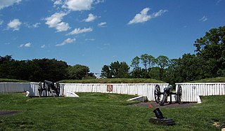
Fort Ward is a former Union Army installation now located in the city of Alexandria in the U.S. state of Virginia. It was the fifth largest fort built to defend Washington, D.C. in the American Civil War. It is currently well-preserved with 90-95% of its earthen walls intact.

<span class="mw-page-title-main">Fort Reynolds (Virginia)</span>

Fort Reynolds was a Union Army redoubt built as part of the defenses of Washington, D.C., in the American Civil War.

<span class="mw-page-title-main">Arlington Line</span> Union Army fortifications around Washington, D.C. during the Civil War (1860s)

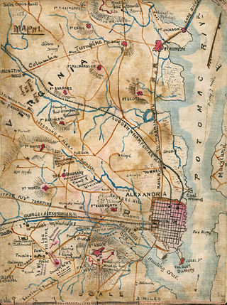
The Arlington Line was a series of fortifications that the Union Army erected in Alexandria County, Virginia, to protect the City of Washington during the American Civil War.

<span class="mw-page-title-main">Fort Corcoran</span>

Fort Corcoran was a wood-and-earthwork fortification constructed by the Union Army in northern Virginia as part of the defenses of Washington, D.C. during the American Civil War. Built in 1861, shortly after the occupation of Arlington, Virginia by Union forces, it protected the southern end of the Aqueduct Bridge and overlooked the Potomac River and Theodore Roosevelt Island, known as Mason's Island.

<span class="mw-page-title-main">Fort Runyon</span> Historical fort in Arlington, Virginia, United States

Fort Runyon was a timber and earthwork fort constructed by the Union Army following the occupation of northern Virginia in the American Civil War in order to defend the southern approaches to the Long Bridge as part of the defenses of Washington, D.C. during that war. The Columbia Turnpike and Alexandria and Loudon Railroad ran through the pentagonal structure, which controlled access to Washington via the Long Bridge. With a perimeter of almost 1,500 yards (1,400 m), and due to its unusual shape it was approximately the same size, shape, and in almost the same location as the Pentagon, built 80 years later.

<span class="mw-page-title-main">Fort Jackson (Virginia)</span> Historical fort in Virginia

Fort Jackson was an American Civil War-era fortification in Virginia that defended the southern end of the Long Bridge, near Washington, D.C. Long Bridge connected Washington, D.C. to Northern Virginia and served as a vital transportation artery for the Union Army during the war. Fort Jackson was named for Jackson City, a seedy suburb of Washington that had been established on the south side of the Long Bridge in 1835. It was built in the days immediately following the Union Army's occupation of Northern Virginia in May 1861. The fort was initially armed with four cannon used to protect the bridge, but these were removed after the completion of the Arlington Line, a line of defenses built to the south. After 1862, the fort lacked weapons except for small arms and consisted of a wooden palisade backed by earthworks. Two cannon were restored to the fort in 1864 following the Battle of Fort Stevens. The garrison consisted of a single company of Union soldiers who inspected traffic crossing the bridge and guarded it from potential saboteurs.

<span class="mw-page-title-main">Fort Lyon (Virginia)</span> Historic fort in Virginia, USA

Fort Lyon was a timber and earthwork fortification constructed south of Alexandria, Virginia as part of the defenses of Washington, D.C. during the American Civil War. Built in the weeks following the Union defeat at Bull Run, Fort Lyon was situated on Ballenger's Hill south of Hunting Creek, and Cameron Run, near Mount Eagle. From its position on one of the highest points south of Alexandria, the fort overlooked Telegraph Road, the Columbia Turnpike, the Orange and Alexandria Railroad, the Little River Turnpike, and the southern approaches to the city of Alexandria, the largest settlement in Union-occupied Northern Virginia.

Fort Worth was a timber and earthwork fortification constructed west of Alexandria, Virginia as part of the defenses of Washington, D.C. during the American Civil War.

<span class="mw-page-title-main">Fort Ellsworth</span>

Fort Ellsworth was a timber and earthwork fortification constructed west of Alexandria, Virginia, as part of the defenses of Washington, D.C. during the American Civil War. Built in the weeks following the Union defeat at Bull Run, Fort Ellsworth was situated on a hill north of Hunting Creek, and Cameron Run,. From its position on one of the highest points west of Alexandria, the fort overlooked the Orange and Alexandria Railroad, the Little River Turnpike, and the southern approaches to the city of Alexandria, the largest settlement in Union-occupied Northern Virginia.

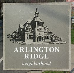
Arlington Ridge Road is a street through residential areas and business districts in Arlington County, Virginia in the United States. South Arlington Ridge Road is roughly 1.5 miles in length and extends from Prospect Hill Park/Army-Navy Drive in the north to Glebe Road and Four Mile Run creek in the south. As it crosses the creek it turns into Mount Vernon Avenue. Arlington Ridge Road was first constructed in 1840, and formerly extended north through Arlington National Cemetery to Rosslyn, Virginia near Francis Scott Key Bridge and the Potomac River.

Nauck is a neighborhood in the southern part of Arlington County, Virginia, known locally as Green Valley. It is bordered by Four Mile Run and Shirlington to the south, Douglas Park to the west, I-395 to the east, and Columbia Heights and the Army-Navy Country Club to the north. The southeastern corner of the neighborhood borders the City of Alexandria.

The Hume Springs neighborhood in Alexandria, Virginia is a subdivision of red-brick row houses built in 1942. Hume Springs has roughly 175 homes situated on four streets, East Reed Avenue, Dale Street, Edison Street, and Mark Drive. The neighborhood is bordered on the north and east by Four Mile Run Park, a 48.22 acre park that is the largest suburban park in the DC area. Directly north of Hume Springs is Four Mile Run stream and Arlington, Virginia. Directly east of Hume Springs is the Cora Kelly Recreation Center, and 12 mile further is Route 1 and Potomac Yard. Directly west of Hume Springs is Arlandria, largely a Latino El Salvadorian community since the 1980s, and home to the Birchmere concert hall, the Alexandria Aces baseball team, Four Mile Run Farmers and Artisans Market, and St. Rita's Church, built in 1949 of stoned Gothic architecture. To the South of Hume Springs is the historic Del Ray neighborhood with numerous restaurants, sidewalk seating, annual festivals and a popular farmer's market.

<span class="mw-page-title-main">Fort Farnsworth</span>

Fort Farnsworth is a former Union Army installation now located in the Huntington area of Fairfax County, Virginia. It was a timber and earthwork fortification constructed south of Alexandria, Virginia as part of the defenses of Washington, D.C. during the American Civil War. Nothing survives of the fort's structure as the Huntington Station of the Washington Metro occupies Fort Farnsworth's former hilltop site.

References