A county seat is an administrative center, seat of government, or capital city of a county or civil parish. The term is in use in five countries: Canada, China, Hungary, Romania, and the United States. An equivalent term, shire town, is used in the U.S. state of Vermont and in several other English-speaking jurisdictions. County towns usually serve a similar function in Ireland, Jamaica, and the United Kingdom.

Manassas Park is an independent city in the U.S. state of Virginia. As of the 2020 census, the population was 17,219. Manassas Park is bordered by the city of Manassas and Prince William County. Manassas Park is a part of the Washington-Arlington-Alexandria, DC-VA-MD-WV Metropolitan Statistical Area.

Henrico County, officially the County of Henrico, is located in the Commonwealth of Virginia in the United States. As of the 2020 census, the population was 334,389 making it the fifth-most populous county in Virginia. Henrico County is included in the Greater Richmond Region. There is no incorporated community within Henrico County; therefore, there is no incorporated county seat either. Laurel, an unincorporated CDP, serves this function.

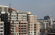
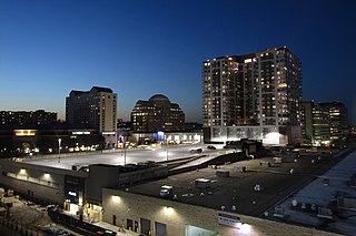
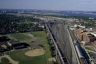
Arlington County, or simply Arlington, is a county in the U.S. state of Virginia. The county is located in Northern Virginia on the southwestern bank of the Potomac River directly across from Washington, D.C., the national capital.

Arlington is a town in Shelby County, Tennessee, United States. The population was 2,569 at the 2000 census, 11,517 at the 2010 census, and 14,549 at the 2020 Census. From 2010 until 2020 the town's population grew by 26.326%. It is one of the seven municipalities in Shelby County. The town lies wholly within the borders of Shelby County.

Clarendon is an urbanized, upper-class neighborhood in Arlington County, Virginia, located between the Rosslyn area and the Ballston area. It was named after Edward Hyde, 1st Earl of Clarendon, a leading statesman and historian of the English Civil War. The main thoroughfares are Wilson Boulevard and Clarendon Boulevard.
Pentagon City is an unincorporated neighborhood located in the southeast portion of Arlington County, Virginia. It is located near The Pentagon and Arlington National Cemetery.

Court House, also known as Courthouse, is a transit-oriented neighborhood in Arlington County, Virginia. It is centered around the Court House station on the Orange Line and the Silver Line of the Washington Metro.
Potomac Yard is a neighborhood in Northern Virginia that straddles southeastern Arlington County and northeastern Alexandria, Virginia, located principally in the area between U.S. Route 1 and the Washington Metro Blue Line /Yellow Line tracks, or the George Washington Memorial Parkway, depending on the definition usedF. The area was home to what was once one of the busiest rail yards on the Eastern Seaboard of the United States. The "Potomac Yard" name is also used to refer to several developments in the area, especially the Potomac Yard Center power center and a Washington Metro station.

The state highway system of the U.S. state of Virginia is a network of roads maintained by the Virginia Department of Transportation (VDOT). As of 2006, the VDOT maintains 57,867 miles (93,128 km) of state highways, making it the third-largest system in the United States.

Fairlington is an unincorporated neighborhood in Arlington County, Virginia, United States, located adjacent to Shirlington in the southernmost part of the county on the boundary with the City of Alexandria. The main thoroughfares are Interstate 395 which divides the neighborhood into North and South Fairlington, State Route 7 and State Route 402.

U.S. Route 50 is a transcontinental highway which stretches from Ocean City, Maryland to West Sacramento, California. In the U.S. state of Virginia, US 50 extends 86 miles (138 km) from the border with Washington, D.C. at a Potomac River crossing at Rosslyn in Arlington County to the West Virginia state line near Gore in Frederick County.

There are more than 500 neighborhoods within the area of Jacksonville, Florida, the largest city in the contiguous United States by area. These include Downtown Jacksonville and surrounding neighborhoods. Additionally, greater Jacksonville is traditionally divided into several major sections with amorphous boundaries: Northside, Westside, Southside, and Arlington, as well as the Jacksonville Beaches.
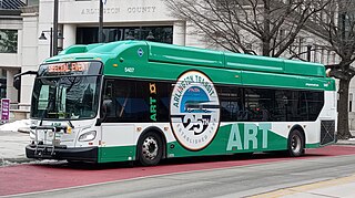
Arlington Transit (ART) is a bus transit system that operates in Arlington County, Virginia, and is managed by the county government. The bus system provides service within Arlington County, and connects to Metrobus, nearby Metrorail stations, Virginia Railway Express, and other local bus systems. Most ART routes serve to connect county neighborhoods to local Metrorail stations, as well as the Shirlington Bus Station. It includes part of the Pike Ride service along Columbia Pike, which is shared with WMATA. In 2023, the system had a ridership of 2,258,200, or about 8,100 per weekday as of the fourth quarter of 2023.

State Route 237 is a primary state highway in the U.S. state of Virginia. The state highway runs 13.07 miles (21.03 km) from SR 236 in Fairfax east to U.S. Route 50 in Arlington. SR 237 connects Fairfax and Arlington with Falls Church. Between Fairfax and Falls Church, the state highway mostly runs concurrently with US 29. East of Falls Church, SR 237 parallels Interstate 66 (I-66) and connects several of Arlington's urban villages.
In the United States, an independent city is a city that is not in the territory of any county or counties and is considered a primary administrative division of its state. Independent cities are classified by the United States Census Bureau as "county equivalents" and may also have similar governmental powers to a consolidated city-county or a unitary authority. However, in the case of a consolidated city-county, a city and a county were merged into a unified jurisdiction in which the county at least nominally exists to this day, whereas an independent city was legally separated from any county or merged with a county that simultaneously ceased to exist even in name.
Arlington County Board v. Richards, 434 U.S. 5 (1977), is a United States Supreme Court decision on the application of the Equal Protection Clause of the Fourteenth Amendment to the Constitution to municipal parking restrictions. In a unanimous per curiam opinion, the Court held that a residential zoned parking system requiring permits for daytime parking in the Aurora Highlands neighborhood of Arlington County, Virginia, with those permits limited to residents, their guests and those who came to their homes for business purposes had a rational basis and was thus constitutional. Its decision overturned the Virginia Supreme Court.