Jambi

Last updated
Jambi
Province of Jambi
Coat of arms of Jambi.svg
Motto(s): 
Sepucuk Jambi Sembilan Lurah (Jambi Malay)
(One Jambi indigenous territory, formed by nine river settlements)
Jambi in Indonesia.svg
Location of Jambi in Indonesia
OpenStreetMap
Jambi
Coordinates: 1°35′S103°37′E / 1.583°S 103.617°E / -1.583; 103.617
Established6 January 1957
Capital
and largest city
Jambi
Government
  BodyJambi Provincial Government
  Governor Al Haris
  Vice Governor Abdullah Sani  [ id ]
Area
  Total49,026.58 km2 (18,929.27 sq mi)
  Rank11th
Elevation
500 m (1,600 ft)
Highest elevation3,805 m (12,484 ft)
Population
 (mid 2023 estimate) [1]
  Total3,679,169
  Rank19th
  Density75/km2 (190/sq mi)
   Rank23rd
Demographics
   Ethnic groups 43.57% Jambi Malays
29.10% Javanese
5.37% Other Malays
5.33% Minangkabau
3.46% Batak
3.33% Banjarese
3.13% Buginese
2.58% Sundanese
1.88% Palembang
1.215 Chinese
1.04% Others [2]
   Religion 95.08% Islam
3.88% Christianity
- 3.31% Protestant
- 0.58% Catholic
0.94% Buddhism
0.06% Folk religion
0.02% Confucianism
0.013% Hinduism [3]
   Languages Indonesian (official)
Jambi Malay, Kerinci, Kubu (regional)
GDP (nominal)2022
 - Total [4] Rp 276.3 trillion (15th)
US$ 18.6 billion
Int$ 58.1 billion (PPP)
 - Per capita [5] Rp 76.1 million (8th)
US$ 5,125
Int$ 15,991 (PPP)
 - Growth [6] Increase2.svg 5.13%
HDI Increase2.svg 0.728 (19th) – high
Website jambiprov.go.id

Jambi is a province of Indonesia. It is located on the east coast of central Sumatra and stretches to the Barisan Mountains in the west. Its capital and largest city is also called Jambi. It is bordered by the provinces of Riau to the north, West Sumatra to the west, Bengkulu to the southwest, South Sumatra to the south, and shares a maritime border with the Riau Islands to the east and the Pacific Ocean to the east. The province has a land area of 49,026.58 km2, and a sea area of 3,274.95 km2. It's area is comparable to the European country of Slovakia. It had a population of 3,092,265 according to the 2010 census [7] and 3,548,228 according to the 2020 census; [2] the official estimate of population as of mid-2023 was 3,679,169 (comprising 1,872,177 males and 1,806,992 females). [1]

Contents

History

Mosque in Jambi, during the colonial period. ca 1900-1939. COLLECTIE TROPENMUSEUM Moskee Djambi TMnr 10016664.jpg
Mosque in Jambi, during the colonial period. ca 1900–1939.

Jambi was the site of the Melayu kingdom that engaged in trade throughout the Strait of Malacca and beyond. It was recorded as having sent a mission to China in 644 CE. It was annexed by Srivijaya by 685 CE, but tried to declare its independence in the 9th century. Jambi succeeded Palembang, its southern economic and military rival, as the major player in trade in the Malacca straits. After the 1025 Chola raids in Southeast Asia, Jambi still sent missions to China. [8] :72,114

In the early decades of the Dutch presence in the region, when the Dutch were one of several traders competing with the British, Chinese, Arabs, and Malays, the Jambi Sultanate profited from trade in pepper with the Dutch. This relationship declined by about 1770, and the sultanate had little contact with the Dutch for about sixty years.[ citation needed ]

In 1833, minor conflicts with the Dutch East Indies who were well established in Palembang, meant the Dutch increasingly felt the need to control the actions of Jambi. They coerced Sultan Facharudin to agree to greater Dutch presence in the region and control over trade, although the sultanate remained nominally independent. In 1858 the Dutch, concerned over the risk of competition for control from other foreign powers, invaded Jambi with a force from their capital Batavia. They met little resistance, and Sultan Taha fled upriver, to the inland regions of Jambi. The Dutch installed a puppet ruler, Nazarudin, in the lower region, which included the capital city. For the next forty years Taha maintained the upriver kingdom, and slowly reextended his influence over the lower regions through political agreements and marriage connections. In 1904, however, the Dutch were stronger and, as a part of a larger campaign to consolidate control over the entire archipelago, managed to capture and kill Taha, and in 1906, the entire area was brought under direct colonial control.

Following the death of Jambi Sultan, Taha Saifuddin, on 27 April 1904 and the success of the Dutch controlled areas of the Sultanate of Jambi, Jambi then was set up as a Residency and entry into the territory Netherlands Indies. Jambi's first Resident OL Helfrich was appointed by the governor general under Dutch Decree No. 20, dated 4 May 1906, with his inauguration held on 2 July 1906.

In 1945, Sumatra comprised a single province, but in 1948 this was divided into three provinces, including the province of Central Sumatra (which included present-day Jambi Province). In 1957 this short-lived province was itself divided, and Jambi was created as an independent Province.

Historical population
YearPop.±%
1971 1,006,084    
1980 1,445,994+43.7%
1990 2,020,568+39.7%
1995 2,369,959+17.3%
2000 2,407,166+1.6%
2005 2,635,968+9.5%
2010 3,092,265+17.3%
2015 3,397,164+9.9%
2020 3,548,228+4.4%
2023 3,679,169+3.7%
Source: Badan Pusat Statistik [1] 2024 and previous

Administrative divisions

When Jambi Province was created in 1957, it comprised three regencies - Kerinci (renamed from South Pesisir Regency on 19 March 1956), Batanghari and Bungo Tebo - as well as the independent city of Jambi City . On 14 June 1965 two new regencies were formed - Sarolangun Bangko from part of Bungo Tebo Regency, and Tanjung Jabung from part of Batanghari Regency. On 4 October 1999 four additional regencies were created by splitting each of four existing regencies in two - Muara Jambi was formed from part of Batanghari Regency, while Sarolangun Bangko Regency was split into separate Sarolangun and Merangin Regencies, Tanjung Jabung Regency was split into separate Tanjung Jabung Barat (West Tanjung Jabung) and Tanjung Jabung Timur (East Tanjung Jabung) Regencies, and Bungo Tebo Regency was split into separate Bungo and Tebo Regencies. Finally, a second independent city of Sungai Penuh (Penuh River) was split off from Kerinci Regency on 1 July 2008.

Thus Jambi province is now divided into nine regencies (kabupaten) and two cities (kota), listed below with their areas and their populations at the 2010 [7] and 2020 [2] censuses, together with the official estimates as at mid 2023. [1] These are divided into 141 districts (kecamatan), in turn sub-divided into 153 urban villages (kelurahan) and 1,399 rural villages (desa).

Kode
Wilayah
Name of
City or
Regency
Area
in
km2
Pop'n
census
2010
Pop'n
census
2020
Pop'n
estimate
mid 2024
Capital HDI [9]
2018 Estimates
15.01 Kerinci Regency 3,445.20229,495250,259255,120 Siulak 0.705 (High)
15.02 Merangin Regency 7,540.12333,206354,052368,390 Bangko 0.688 (Medium)
15.03 Sarolangun Regency 5,935.89246,245290,047302,240 Sarolangun 0.694 (Medium)
15.04 Batanghari Regency 5,387.52241,334301,700312,730 Muara Bulian 0.693 (Medium)
15.05 Muaro Jambi Regency 5,225.80342,952402,017418,800 Sengeti 0.683 (Medium)
15.06 West Tanjung Jabung Regency
(Tanjung Jabung Barat)
5,546.06278,741317,498330,470 Kuala Tungkal 0.671 (Medium)
15.07 East Tanjung Jabung Regency
(Tanjung Jabung Timur)
4,546.62205,272229,813236,730 Muara Sabak 0.633 (Medium)
15.08 Bungo Regency 4,760.83303,135362,363376,380 Muara Bungo 0.694 (Medium)
15.09 Tebo Regency 6,103.74297,735337,669350,760 Muara Tebo 0.686 (Medium)
15.71 Jambi City 169.89531,857606,200627,770-0.774 (High)
15.72 Sungai Penuh City 364.9282,29396,61099,770-0.746 (High)
Total province49,026.583,092,2653,548,2283,679,169Jambi0.705 (High)

World Heritage Sites

Mount Kerinci, the tallest mountain in Sumatra Uprising-mount kerinci.jpg
Mount Kerinci, the tallest mountain in Sumatra
Muaro Jambi Temples Candi Tinggi.jpg
Muaro Jambi Temples
Detail of a Kain Batik Tulisan, late 19th century, from an unknown village in Jambi. Kain Batik Tulisan, Sumatera.png
Detail of a Kain Batik Tulisan, late 19th century, from an unknown village in Jambi.

The largest of the three national parks comprising the Tropical Rainforest Heritage of Sumatra, Kerinci Seblat has the distinction of being the second-largest national park in all of Southeast Asia, only after Lorentz National Park on Papua. It is one of the Sumatran Tiger's last strongholds on the island, and within its borders sits the highest active volcano in Southeast Asia - Mount Kerinci.

May 2011: The Jambi provincial administration is striving to have the ancient Muaro Jambi temple site at Muaro Jambi village in Maro Sebo District, Muaro Jambi Regency, recognized as a World Heritage Site.

The site was a Buddhist education centre that flourished during the 7th and 8th centuries and is made from bricks similar to those used in Buddhist temples in India. [10]

Demographics

Due to transmigration policy, many ethnic groups from various parts of Indonesia, especially Java, Borneo, Sulawesi and other parts of Sumatra brought their native languages as well. The non-Pribumi people such as the Chinese Indonesians speak several varieties of Chinese.

Ethnically, the population comprises:

As of 2022, Islam is the largest religion in Jambi, being practised by 96.09% of the population. Minority religions are Christianity with 3,9%, Buddhism 0.92%, Confucianism 0.02% and Hinduism 0.01% of the population. [11]

See also

Related Research Articles

<span class="mw-page-title-main">West Kalimantan</span> Province of Indonesia

West Kalimantan is a province of Indonesia. It is one of five Indonesian provinces comprising Kalimantan, the Indonesian part of the island of Borneo. Its capital and largest city is Pontianak. It is bordered by East Kalimantan and Central Kalimantan to the east, the Malaysian state of Sarawak to the north, and the Pacific Ocean to the west and the Java Sea to the south. The province has an area of 147,307 km2, and had a population of 4,395,983 at the 2010 Census and 5,414,390 at the 2020 Census; the official estimate as at mid 2022 was 5,541,376. Ethnic groups include the Dayak, Malay, Chinese, Javanese, Bugis, and Madurese. The borders of West Kalimantan roughly trace the mountain ranges surrounding the vast watershed of the Kapuas River, which drains most of the province. The province shares land borders with Central Kalimantan to the southeast, East Kalimantan to the east, and the Malaysian territory of Sarawak to the north.

<span class="mw-page-title-main">North Sulawesi</span> Province of Indonesia

North Sulawesi is a province of Indonesia. It is mainly located on the Minahasa Peninsula of the island of Sulawesi, south of the Philippines and southeast of Sabah, Malaysia, but also includes various small archipelagoes situated between the Minahasa Peninsula and the southern Philippines. It borders the Philippine province of Davao Occidental and Soccsksargen regions of the Philippines to the north, the Maluku Sea to the east, Gorontalo and Celebes Sea to the west and the Gulf of Tomini to the southwest. The province's furthest extent, the outlying and isolated island of Miangas to its north, is the northernmost island of Indonesia.

<span class="mw-page-title-main">Lampung</span> Province of Indonesia

Lampung, officially the Province of Lampung, is a province of Indonesia. It is located on the southern tip of the island of Sumatra. It has a short border with the province of Bengkulu to the northwest, and a longer border with the province of South Sumatra to the north, as well a maritime border with the province of Banten and Jakarta to the east. It is the original home of the Lampung people, who speak their own language, and possess their own written script. Its capital is Bandar Lampung.

<span class="mw-page-title-main">West Nusa Tenggara</span> Province of Indonesia

West Nusa Tenggara is a province of Indonesia. It comprises the western portion of the Lesser Sunda Islands, with the exception of Bali which is its own province. The province's land area is 19,931.45 km2. The two largest islands by far in the province are the smaller but much more populated Lombok in the west and the much larger in area but much less densely populated Sumbawa island in the east. Mataram, on Lombok, is the capital and largest city of the province. It shares maritime borders with Bali to the west and East Nusa Tenggara to the east.

<span class="mw-page-title-main">Surabaya metropolitan area</span> Metropolitan area in East Java, Indonesia

The Surabaya metropolitan area or Greater Surabaya, known locally as Gerbangkertosusila, is a metropolitan area in East Java, Indonesia. It is the country's second-largest metropolitan area, after Jakarta metropolitan area. Gerbangkertosusila had also been used in presidential decree to refer to larger region which include Jombang, Bojonegoro, and Tuban.

<span class="mw-page-title-main">Jambi (city)</span> City and capital of Jambi, Indonesia

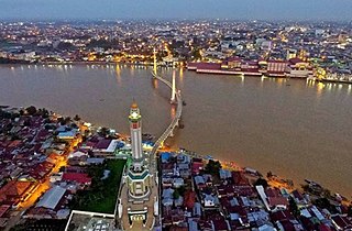
Jambi is the capital and largest city of the Indonesian province of Jambi. Located on the island of Sumatra, the city is a busy port on the Batang Hari River and an oil- and rubber-producing centre. The city is located 26 km (16 mi) from the ruins of Muaro Jambi Temple Compounds, an important city in the ancient Srivijaya kingdom.

<span class="mw-page-title-main">Muaro Jambi Regency</span> Regency in Jambi, Indonesia

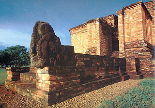
Muaro Jambi Regency is a regency of Jambi Province, Sumatra, Indonesia. It was created on 4 October 1999 by the separation of what were formerly the eastern districts of Batang Hari Regency. It surrounds the major city of Jambi, the provincial capital, and includes many of the expanding suburbs of Jambi outside the city boundaries; consequently it has experienced population growth greater than elsewhere in the province. From the 4th until the 13th century, it was the seat of the Hindu-Buddhist Melayu Kingdom. It has an area of 5,246.00 km2 and had a population of 342,952 at the 2010 census and 390,347 at the 2020 census; the official estimate as at mid 2022 is 412,830.

<span class="mw-page-title-main">Kerinci Regency</span> Regency in Jambi, Indonesia

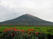
Kerinci is a regency (kabupaten) in Jambi province, on the island of Sumatra, Indonesia. The regency has an area of 3,448.90 km2 (1,331.63 sq mi). Kerinci Regency had a population of 229,495 at the 2010 Census and 250,259 at the 2020 Census; the official estimate as at mid 2022 was 253,863. The regency largely surrounds the city of Sungai Penuh, which until its separation on 24 June 2008 was part of the regency but is now independent of it. The regency seat is at Siulak. Kerinci is located 50 km (31 mi) from Jambi City, the capital of Jambi Province. Much of the landmass of the Kerinci regency is within the boundaries of the Kerinci Seblat National Park

<span class="mw-page-title-main">Batanghari Regency</span> Regency in Jambi, Indonesia

Batanghari is a regency of Jambi Province in Sumatra, Indonesia. It originally covered a wider area, but on 4 October 1999 this was split between a new Muaro Jambi Regency in the east and a reduced Batang Hari Regency in the west, which now covers an area of 5,804.83 km2. It had a population of 241,334 at the 2010 census and 301,700 at the 2020 census; the official estimate as at mid 2022 was 313,209. The administrative capital is the town of Muara Bulian.

<span class="mw-page-title-main">North Kalimantan</span> Province of Indonesia

North Kalimantan is a province of Indonesia. It is located on the northernmost of Kalimantan, the Indonesian part of the island of Borneo. North Kalimantan borders the Malaysian states of Sabah to the north and Sarawak to the west, and by the Indonesian province of East Kalimantan to the south. Tanjung Selor serves as the capital of the province, while Tarakan is the largest city and the financial centre.

<span class="mw-page-title-main">Sungai Penuh</span> City in Jambi, Indonesia

Sungai Penuh is a city in Indonesia, in Jambi province, on the island of Sumatra. It is an enclave within Kerinci Regency, of which it was formerly part but from which it became administratively separate on 24 June 2008. The city, whose name means "Penuh River", is also known as Siulak. It covers an area of 391.50 km2 and had a population of 82,293 at the 2010 Census and 96,610 at the 2020 Census; the official estimate as at mid 2022 was 99,233.

<span class="mw-page-title-main">Bungo Regency</span> Regency in Indonesia

Bungo Regency is a regency (kabupaten) of Jambi Province in Sumatra, Indonesia. It was created on 4 October 1999 by the division of the former Bungo Tebo Regency into a new Tebo Regency and this Bungo Regency. The regency covers an area of 4,659 km2. As at the 2010 census, the regency had a population of 303,135 and 362,363 at the 2020 census; the official estimate as at mid 2022 was 373,344. The administrative capital is the town of Muara Bungo.

<span class="mw-page-title-main">Merangin Regency</span> Regency in Jambi, Indonesia

Merangin is a regency (kabupaten) of Jambi Province on the island of Sumatra, Indonesia. It was created on 4 October 1999 by the division of the former Sarolangun Bangko Regency into a new Sarolangun Regency and this Merangin Regency. The regency covers an area of 7,668.61 km2, and had a population of 333,206 at the 2010 census and 354,052 at the 2020 census; the official estimate as at mid 2022 was 357,577, comprising 181,850 males and 175,727 females. The administrative capital is the town of Bangko.

<span class="mw-page-title-main">Sarolangun Regency</span> Regency in Jambi, Indonesia

Sarolangun Regency is a regency of Jambi Province, Indonesia. It is located on the island of Sumatra. It was created on 4 October 1999 by the division of the former Sarolangun Bangko Regency into a new Merangin Regency and this Sarolangun Regency. The regency has an area of 5,941.13 km2 and had a population of 246,245 at the 2010 census and 290,047 at the 2020 census; the official estimate as at mid 2022 was 298,091. The administrative centre is at the town of Sarolangun.

<span class="mw-page-title-main">East Tanjung Jabung Regency</span> Regency in Jambi, Indonesia

East Tanjung Jabung Regency is a regency of Jambi Province, Indonesia. It is located on the island of Sumatra. The regency was created on 4 October 1999 by the division of the then Tanjung Jabung Regency into eastern and western halves. It now has an area of 5,085.71 km2 and had a population of 205,272 at the 2010 census and 229,813 at the 2020 census; the official estimate as at mid 2022 was 234,164. The capital lies at Muara Sabak.

<span class="mw-page-title-main">West Tanjung Jabung Regency</span> Regency in Jambi, Indonesia

West Tanjung Jabung Regency is a regency of Jambi Province, Indonesia. It is located on the island of Sumatra. The regency was created on 4 October 1999 by the division of the then Tanjung Jabung Regency into eastern and western halves. It now has an area of 5,009.82 km2 and had a population of 278,741 as at the 2010 census and 317,498 at the 2020 census; the official estimate as at mid 2022 was 326,530. The regency seat is Kuala Tungkal.

<span class="mw-page-title-main">Tebo Regency</span> Regency in Jambi, Indonesia

Tebo Regency is a regency of Jambi Province, Indonesia. It is located on the island of Sumatra, and was created on 4 October 1999 by the division of the former Bungo Tebo Regency into a new Bungo Regency and this Tebo Regency. The regency has an area of 6,461 km² and had a population of 297,735 at the 2010 Census and 337,669 at the 2020 Census; the official estimate as at mid 2022 was 344,816. The regency seat is at the town of Muara Tebo.

References

  1. 1 2 3 4 Badan Pusat Statistik, Jakarta, 28 February 2024, Provinsi Jambi Dalam Angka 2024 (Katalog-BPS 1102001.15)
  2. 1 2 3 4 Badan Pusat Statistik, Jakarta, 2021.
  3. "ArcGIS Web Application".
  4. Badan Pusat Statistik (2023). "Produk Domestik Regional Bruto (Milyar Rupiah), 2022" (in Indonesian). Jakarta: Badan Pusat Statistik.
  5. Badan Pusat Statistik (2023). "Produk Domestik Regional Bruto Per Kapita (Ribu Rupiah), 2022" (in Indonesian). Jakarta: Badan Pusat Statistik.
  6. Badan Pembangunan Nasional (2023). "Capaian Indikator Utama Pembangunan" (in Indonesian). Jakarta: Badan Pembangunan Nasional.
  7. 1 2 Biro Pusat Statistik, Jakarta, 2011.
  8. Miksic, John M. (2013). Singapore and the Silk Road of the Sea, 1300–1800. NUS Press. ISBN   9789971695583.
  9. All Stats search jambi.bps.go.id
  10. "Waspada Online – Pusat Berita dan Informasi Medan Sumut Aceh". waspada.co.id. Retrieved 22 March 2018.
  11. "Jumlah Penduduk Menurut Agama" (in Indonesian). Ministry of Religious Affairs. 31 August 2022. Retrieved 29 October 2023.

Bibliography