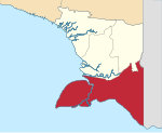
South Papua, officially the South Papua Province (Indonesian: Provinsi Papua Selatan),[3] is an Indonesian province located in the southern portion of Papua, following the borders of the Papuan customary region of Anim Ha.[4][5] Formally established on 11 November 2022 and including the four most southern regencies that were previously part of the province of Papua and before 11 December 2002 had comprised a larger Merauke Regency, it covers a land area of 129,715.02km2, about the same area as Pennsylvania (or 90% of that of England). This area had a population of 513,617 at the 2020 Census,[6] while the official estimate as at mid 2023 was 537,973,[1] making it the least populous province in Indonesia.
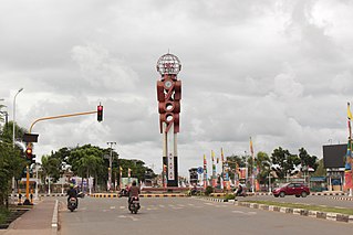
It shares land borders with the sovereign state of Papua New Guinea to the east, as well as the Indonesian provinces of Highland Papua and Central Papua to the north and northwest, respectively. South Papua also faces the Arafura Sea in the west and south, which is a maritime border with Australia. Merauke is the economic centre of South Papua, while its administrative centre is the town of Salor located in Kurik District of Merauke Regency, around 60km northwest of Merauke.[7]
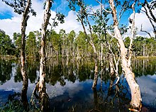
South Papua landscape predominantly consists of lowland areas characterized by extensive swamps and massive rivers such as the Digul and Maro. Indigenous ethnic group inhabiting this region for example Asmat, Marind, Muyu, and Korowai. They rely on sago and fish as staple dietary sources. Certain tribes like Asmat were recognized for its wood carving and boating culture. There is also massive amount of migrant like Javanese people because of transmigration program sponsored by the government to convert vast amount of swamps into rice paddy and increase this region's population. South Papua is also home to the renowned Wasur National Park, an expansive wetland area with rich biodiversity including agile wallaby, mound-building termites or musamus, and the bird of paradise.[8][9][10][11]
History
The wetland region of South Papua, before the arrival of Europeans, was home to several indigenous tribes. These tribes included the Asmat, Marind and Wambon, who still maintain their ancestral traditions in the area. The Marind tribe, also known as the Malind, lived in groups along the rivers in the Merauke region, and their way of life centered around hunting, gathering, and farming. However, the Marind tribe was also notorious for their practice of headhunting. They would travel in boats along the rivers and coasts to distant settlements, where they would behead the inhabitants. The heads of their victims would then be taken back to their villages to be preserved and celebrated.[12][13][14]
Marind people in 1910
In the 19th century, European powers began to colonize the island of New Guinea. The island was divided along a straight line, with the western portion falling under the jurisdiction of the Dutch New Guinea region and the eastern portion becoming British New Guinea. Marind people often crossed the border to engage in headhunting activities. In 1902, the Dutch established a military base at the eastern tip of South Papua, near the Maro River, to strengthen the border and eliminate this tradition. This base was named Merauke, after its location. The Dutch also established a Catholic mission in Merauke to spread their religion and to further discourage the practice of headhunting. During the Dutch colonial period, the Javanese people were brought to Merauke to cultivate rice fields. This influx of laborers further contributed to the growth of the town and the development of the surrounding region. Eventually, it became the capital of Afdeeling Zuid Nieuw Guinea or the South New Guinea Province.[12][14]
In addition to the Maro River, the Dutch also became aware of another, larger river known as the Digul River. In the 1920s, the Dutch government sent an expedition to explore the interior of Papua. The idea emerged to use the remote region as a detention camp, and a suitable location was identified at the headwaters of the Digul River or Boven-Digoel. A concentration camp called Tanah Merah was established, it was a densely forested area surrounded by the harsh Digul River, making it difficult for prisoners to escape. Additionally, the region was plagued by malaria, which further discouraged escape attempts. Over the years, several notable figures were detained at the camp, including Mohammad Hatta and Sutan Sjahrir. After the Dutch left in the 1960s, Tanah Merah became more populated and eventually became the capital of the Boven Digoel Regency.[14][15][16]
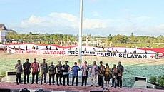
In the 1960s, Indonesian forces took control of all of Dutch New Guinea, including the former Zuid Nieuw Guinea. Following the takeover, the territory was reorganized, and the former Zuid Nieuw Guinea became the Merauke Regency, with its capital located in Merauke. On 11 December 2002, the Merauke Regency was further divided into four separate regencies: Merauke, Mappi, Asmat, and Boven Digoel. These regencies were established to better serve the needs of the local populations and provide more effective governance across the region. More recently, on 25 July 2022, the former territory of the Merauke Regency was officially re-united with other regions in southern Papua to form the new province of South Papua, following the signing of Law No. 14/2022. The name "South Papua" (Papua Selatan) was chosen instead of "Anim Ha" due to the latter term's historical origins during Dutch rule and its potential to be demeaning to other tribes in southern Papua. In contrast, "South Papua" was selected as an inclusive and unifying name that avoids any negative connotations and reflects the diverse and vibrant cultural heritage of the region.[3] The public reception towards South Papua was far more positive compared to the other new provinces of Central Papua and Highlands Papua,[17] with residents spreading a giant Indonesian flag in front of the regent office of Merauke after the province's establishment.[18]
Celebration of South Papua establishment
In 2007, the Regent of Merauke, John Gebze, spearheaded the initiation of the Merauke Integrated Food and Energy Estate (MIFEE), a large-scale development project aimed at enhancing Indonesia's food security. Situated in Merauke, an area renowned for its extensive lowland and fertile terrain, the project sought to capitalize on the region's vast land for agricultural purposes. Originally dubbed the Merauke Integrated Rice Estate (MIRE), with a primary focus on rice cultivation, the initiative later broadened its scope to encompass additional crops such as sugar cane, corn, and oil palm. Officially inaugurated in 2010 during the presidency of Susilo Bambang Yudhoyono, the project garnered participation from numerous private investors. However, its progression faced significant challenges, stemming from divergent perspectives among government entities, investors, and the indigenous Marind community, who held land rights in the area. Furthermore, mounting pressure from non-governmental organizations (NGOs) decrying the project as a violation of indigenous rights and environmental degradation prompted a cessation of new land development activities by the involved companies.[19][20][21] During the time of President Joko Widodo, the Food Estate project was revived in various regions with 200,000 hectares of land designated for Papua Island. The main commodities are corn and rice and are located, among others, in Mappi, Boven Digoel and Merauke.[22]
Geography
Wetland of Wasur National Park
Geographically, most of the South Papua region is located in lowland area which are dominated by two ecoregions or geographical areas that include an ecosystem and biodiversity within it. These ecoregions are Southern New Guinea freshwater swamp forests and Southern New Guinea lowland rain forests. These two ecoregions are crossed by large rivers originated from New Guinea Highlands which is the highest mountainous area in Indonesia.[23] In South Papua, many sago trees are found, which are a staple food for local tribes. Sago thrives in lowland environments and exhibits robust growth even in areas prone to flooding, including swamps, coastal regions, peatlands, and along riverbanks.[24]
The South Papua region was designated as a transmigration program site due to its expansive lowland areas with vast amount of water which offer ideal conditions for rice cultivation. Transmigration districts such as Semangga, Tanah Miring, and Kurik serve as primary sources of agricultural produce destined for markets in the City of Merauke. However, the influx of migrant populations into these areas has introduced non-native species, such as Javan rusa and tilapia fish, which disrupt the established ecosystem. Particularly, the adaptable tilapia fish proliferates rapidly in this environment, outcompeting indigenous fish species and consequently dominating the catches of fishermen in Merauke's rivers.[23][26][27]
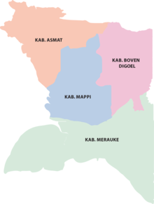
South Papua is divided into four regencies (kabupaten), the least amount compared to other Indonesian provinces. Before 11 December 2002, all four of the current regencies comprised a single Merauke Regency, which was split into the present four regencies on that date. The table below gives the areas of all the regencies,[28] together with their populations at the 2020 Census[6] and according to the official estimates as of mid-2023.[1]
South Papua had a population of 513,617 at the 2020 Census,[6] while the official estimate as at mid 2023 was 537,973 and making it the least populous province in Indonesia.[1]
South Papua is inhabited by local Papuan people from various ethnic group. South Papua are part of customary region of Anim Ha, a distinct region with unique culture compared to other parts of Papua owing to its geography located in lowland area with vast amount of wetland and large rivers. Some of the ethnic group living here including Marind people (with subgroups such as Kimaam) and Yei people in Merauke, Muyu and Wambon people in Boven Digoel, Awyu and Wiyagar people from Mappi, and Asmat people from Asmat. There are also isolated ethnic group found in the border near Highland Papua province like Kombai and Korowai people. Each of the ethnic groups mentioned have unique language.[30]
Religion
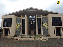
Newly built Roman Catholic Archdiocese of Merauke
According to Ministry of Home Affairs, the percentage of religion in South Papua in 2023 is 72.57% Christianity (49.62% Catholic and 22.95% Protestant), 27.28% Islamic, 0.11% Hindu, and 0.04% Buddhist. Thus, South Papua is the only province on the island of Papua with a percentage of Catholicism that exceeds other religions. This significant number of Catholic residents supports the formation of Roman Catholic Archdiocese of Merauke and Roman Catholic Diocese of Agats which are the ecclesiastical province in the Roman Catholic Church led by either archbishop or bishop.[31][32]
Culture
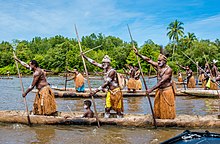
Canoe warriors in Asmat Culture Festival
The native Papuan people have a distinct culture and traditions that cannot be found in other parts of Indonesia. Coastal Papuans are usually more willing to accept modern influence into their daily lives, which in turn diminishes their original culture and traditions. Meanwhile, most inland Papuans still preserve their original culture and traditions, although their way of life over the past century is tied to the encroachment of modernity and globalization.[33] Each Papuan tribe usually practices its traditions and culture, which may differ greatly from one tribe to another.
Hunting as practiced by Marind people usually begins with a traditionally controlled burn of peat bog and swamps, it was then left for three days to a week for new shoots to grow, which will invite game animals such as deer, pigs, saham (kangaroos). The hunting party consists of usually of 7-8 people, then go to the burned locations while bringing food and drink, ranging from tubers, sago, to drinking water, for several days. A temporary hut called bivak would be constructed from barks from Bus, a type of eucalyptus tree to form the walls and the roof made from Lontar leaves.[34] As with many coastal communities from the Moluccas to Papua, Sasi is practiced, which are markers usually constructed from wood and janur to mark the prohibition of harvesting either from land or sea for a while to preserve natural resources and for sustainable harvest.[35] To open and close sasi regions such as forests, usually the Marind-Kanume mark with two arrows shot to the west and to the east to respect three clans that inhabited the area as well as other rituals which can take up to forty days. Violators of the prohibition would be punished with payment of Wati leaves and pigs. Failure of payments will result in referral to local security officers to be put on trial.[36]
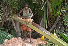
Wood carving
Asmat wood carver
Asmat people are famous internationally for their wood carving. Some of its carving can be found in various museum for example in Asmat Museum of Culture and Progress. Asmat carvings have various motifs such as nature, living creatures, and everyday life. The Asmat people consider that carvings are not only works of art but part of their religious rituals to connect with their ancestors. Asmat carvings are made from local materials such as Merbau and nutmeg wood. One of the famous Asmat carvings is the Bisj Pole which measures more than 3 meters. This pillar consists of figures arranged in tiers. This figure represents the spirits of ancestors killed by their enemies. The top of the pole is decorated like wings.[37][38][39]
Due to the swampy terrain and extensive river networks in South Papua, numerous tribes rely on boats for their daily transportation needs. These traditional vessels, known as perahu lesung, are crafted by hollowing out the center of a single tree trunk and are often embellished with intricate carvings. Typically, these boats are propelled by multiple individuals standing upright and rowing. In ancient times, the Asmat people utilized these boats not only for transportation but also as integral elements of their headhunting customs, which instilled fear in neighboring communities. Historically, Asmat residents would navigate their boats to distant villages, where they would carry out raids and massacres on the inhabitants.[40][41]
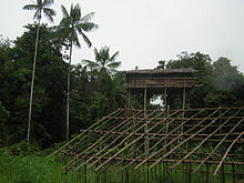
The Korowai people from the Mappi Regency in southern Papua are one of the indigenous tribes in Papua that still adhere to the traditions of their ancestors, one of which is to build houses on top of tall trees called Rumah Tinggi (lit. 'high house'). Some of the Korowai people's tree houses can even reach a height of 50 m above the ground. The Korowai people build houses on top of trees to avoid wild animals and evil spirits. The Korowai people still believe in the myth of Laleo, a cruel demon who often attacks suddenly. Laleo is depicted as an undead that roams at night. According to the Korowai people, the higher the house, the safer it will be from Laleo's attacks. The rumah tinggi is built on big and sturdy trees as the foundation for its foundation. The tops of the trees are then deforested and used as houses. All materials come from nature, logs and boards are used for the roof and floor, while the walls are made of sago bark and wide leaves. The building process for a rumah tinggi usually takes seven days and the structure then lasts up to three years.[42][43]
Cuisine
Sago is a typical Papuan staple food
The staple food of South Papua, in general, is sago, but some tribes also have other staple foods; for example, bananas,[44]ubi (Dioscorea alata), keladi (Colocasia esculenta), sweet potato (Ipomoea batatas), and sukun (Artocarpus incisa and Artocarpus camansi).[45] Sago is either processed as a pancake or sago congee called papeda, usually eaten with yellow soup made from tuna, red snapper or other fishes spiced with turmeric, lime, and other spices. On some coasts and lowlands in Papua, sago is the main ingredient in all the foods. Sagu bakar, sagu lempeng, and sagu bola, have become dishes that are well known to all of Papua, especially in the custom folk culinary tradition of Mappi, Asmat, and Mimika. Papeda is one of the sago foods that is rarely found.[46] As Papua is considered a non-Muslim majority region, pork is readily available everywhere. In Papua, pig roast which consists of pork and yams roasted in heated stones placed in a hole dug in the ground and covered with leaves; this cooking method is called bakar batu (burning the stone), and it is an important cultural and social event among Papuan people.[47] The Marind people used this cooking method or using burning bomi thermite mound made by Macrotermes sp to cook a pizza-like dish called "Sagu Sef", which is made from dough from sago and coconut with sago grub and deer meat. Spices used can include shallot, garlic, coriander, pepper, and salt, which are then mixed and covered with banana leaves, to cook it evenly hot stones or bomi would be put on top of the dish.[48]
Common Papuan snacks are usually made out of sago. Kue bagea (also called sago cake) is a cake originating from Ternate in North Maluku, although it can also be found in Papua.[49] It has a round shape and creamy color. Bagea has a hard consistency that can be softened in tea or water, to make it easier to chew.[50] It is prepared using sago,[51] a plant-based starch derived from the sago palm or sago cycad. Sagu Lempeng is a typical Papuan snack that is made in the form of processed sago in the form of plates. Sagu Lempeng is also a favorite for travelers. But it is very difficult to find places to eat because this bread is a family consumption and is usually eaten immediately after cooking. Making sago plates is as easy as making other breads. Sago is processed by baking it by printing rectangles or rectangles with iron which is ripe like white bread. Initially tasteless, but recently it has begun to vary with sugar to get a sweet taste. It has a tough texture and can be enjoyed by mixing it or dipping it in water to make it softer.[52] Sago porridge is a type of porridge that is found in Papua. This porridge is usually eaten with yellow soup made of mackerel or tuna then seasoned with turmeric and lime. Sago porridge is sometimes also consumed with boiled tubers, such as those from cassava or sweet potato. Vegetable papaya flowers and sautéed kale are often served as side dishes to accompany the sago porridge.[53] In the inland regions, Sago worms are usually served as a type of snack dish.[54][55] Sago worms come from sago trunks which are cut and left to rot. The rotting stems cause the worms to come out. The shape of the sago worms varies, ranging from the smallest to the largest size of an adult's thumb. These sago caterpillars are usually eaten alive or cooked beforehand, such as stir-frying, cooking, frying, and then skewered. But over time, the people of Papua used to process these sago caterpillars into sago caterpillar satay. To make satay from this sago caterpillar, the method is no different from making satay in general, namely on skewers with a skewer and grilled over hot coals.[56]
Economy
Agriculture and forestry
Harvesting of newly created rice fields in Merauke
The vast and fertile geography of South Papua offers abundant agricultural potential. Since the Dutch colonial era, the region has seen the importation of Javanese settlers to cultivate rice fields, particularly in Merauke. This practice continued through the transmigration program post-independence. Consequently, traditional local staples such as sago and tubers have gradually been supplanted by rice and instant food options.[57]
In 2010, the government under Susilo Bambang Yudhoyono initiated the Merauke Integrated Food and Energy Estate (MIFEE) program, aimed at positioning Merauke Regency as one of Indonesia's primary food hubs. Targeted crops under this program encompass rice, corn, and oil palm. However, the project encountered setbacks due to disputes between governmental bodies, corporations, indigenous groups, and non-governmental organizations (NGOs) concerning environmental degradation and alleged human rights infringements against indigenous communities. Consequently, no further land was developed under the initiative.[19][20][21]
In South Papua, extensive oil palms plantations are established in Merauke and Boven Digoel, managed primarily by large corporations. Notably, PT Tunas Sawa Erma (TSE), a subsidiary of Korindo from South Korea, is actively involved in this sector. In addition to palm oil, Korindo is engaged in the timber industry. Under the TSE Group umbrella, operations span across Merauke and Boven Digoel, comprising several subsidiaries, including PT Tunas Sawa Erma (TSE), PT Dongin Prabawa (DP), PT Berkat Cipta Abadi (BCA), and PT Papua Agro Lestari (PAL).[58][59] The distribution of oil palm plantations in South Papua includes the Ngguti, Ulilin and Muting districts in Merauke Regency and the Jair district in Boven Digoel Regency.[60] One of the prominent forestry products in South Papua is sago, serving as the staple food for indigenous tribes residing in the region. In addition to sago, the area is abundant in agarwood or gaharu, derived from species such as Aquilaria and Gyrinops, prized for its aromatic qualities. Agarwood are notably found in Mappi and Asmat. This resource plays a significant role in the livelihoods of tribes in the interior regions due to its high market value. While some gaharu wood is obtained from standing trees, a considerable amount is sourced from mud. Gaharu lumpur, as it is termed, originates from trees that have previously fallen and become submerged in mud, yet retain their aromatic properties.[61][62] In 2020, more than 2 tons of Mappi's agarwood worth 790 million were sold to Jakarta via Merauke's Mopah Airport.[63]
Fisheries
Merauke fisheries port
Arafura Sea, situated to the south of Papua Island, boasts considerable fisheries potential. As highlighted by the Minister of Maritime Affairs and Fisheries, Sakti Wahyu Trenggono, the area witnesses the presence of approximately 20 thousand non-local fishing vessels, resulting in the marginalization of local fishermen and a decline in fish stocks. To address this issue, the Ministry of Maritime Affairs and Fisheries aims to regulate these external vessels by prioritizing the interests of local fishermen and enhancing infrastructure at the Merauke fishing port. This strategy entails mandating that fish caught in the region be transported to Merauke and dispatched via this port, thereby facilitating economic contributions to the local community.[64] To preserve the wealth of natural resources in the Arafura Sea, the Government of South Papua, the Ministry of Maritime Affairs and Fisheries, and UNDP launched the first Marine protected area (MPA) in South Papua Province in July 2023 located on Kolepom Island with an area of 356,337 ha.[65]
One highly prized fishery product is the swim bladder or fish maw, which serves as an organ regulating buoyancy and swimming in fish. Among the most sought-after fish maws are those from croaker or gulama fish. Gulama fish maws fetch a substantial price, with approximately 10 grams of maws commanding around 18 million rupiah per kilogram. In 2018 alone, an estimated 15 thousand tons of gulama fish maws were produced for export to countries like Malaysia and Singapore. Fish maws find applications across various domains, including traditional medicine, luxury cuisine, and even as surgical sutures.[66][67] One prominent player in the fisheries sector is the Chinese company PT Dwikarya Reksa Abadi, operating in Wanam, Ilwayab District, Merauke. However, in 2015, the company faced the revocation of its business license due to violations of regulations, notably including those outlined in Minister of Fisheries Susi Pudjiastuti's directive concerning the moratorium on foreign vessels. This development has had repercussions on the surrounding villages that rely on the company's operations for example access to hospital, electricity generator, and fish refrigeration.[68]
Papua is a province of Indonesia, comprising the northern coast of Western New Guinea together with island groups in Cenderawasih Bay to the west. It roughly follows the borders of Papuan customary region of Tabi Saireri. It is bordered by the sovereign state of Papua New Guinea to the east, the Pacific Ocean to the north, Cenderawasih Bay to the west, and the provinces of Central Papua and Highland Papua to the south. The province also shares maritime boundaries with Palau in the Pacific. Following the splitting off of twenty regencies to create the three new provinces of Central Papua, Highland Papua, and South Papua on 30 June 2022, the residual province is divided into eight regencies and one city (kota), the latter being the provincial capital of Jayapura. The province has a large potential in natural resources, such as gold, nickel, petroleum, etc. Papua, along with five other Papuan provinces, has a higher degree of autonomy level compared to other Indonesian provinces.
The Korowai, also called the Kolufo, are the people who live in southeastern Papua in the Indonesian provinces of South Papua and Highland Papua. Specifically their tribal area is split by the borders of Boven Digoel Regency, Mappi Regency, Asmat Regency, and Yahukimo Regency. They number about 4000 to 4400 people.
Western New Guinea, also known as Papua, Indonesian New Guinea, and Indonesian Papua, is the western, Indonesian half of the island of New Guinea, granted to Indonesia in 1962. Given the island is alternatively named Papua, the region is also called West Papua.
Merauke Regency is a regency in the far south of the Indonesian province of South Papua. It covers an area of 45,013.35 km2, and had a population of 195,716 at the 2010 Census and 230,932 at the 2020 Census; the official estimate as at mid 2023 was 243,722, comprising 126,508 males and 117,214 females. The administrative centre is the town of Merauke; this was projected since 2013 to become an independent city (kota) separate from Merauke Regency, but the alteration has been deferred. It is also the provincial capital of the province of South Papua, more specifically in Salor located in Kurik District. Merauke is the largest regency in Indonesia, with an area of 45,013.35 km2, slightly larger than Estonia.
Merauke, also known as the District of Merauke, is a large town in South Papua, Indonesia. It is also the administrative centre of Merauke Regency. It is considered the easternmost city in Indonesia. The town was originally called Ermasoe. It is next to the Maro River where the Port of Merauke is located. As of the 2010 census, Merauke had a population of 87,634 which at the 2020 Census had increased to 102,351.
Asmat Regency is a regency (kabupaten) in the northwestern portion of the Indonesian province of South Papua. It is bounded to the southwest by the Arafura Sea, to the southeast and east by Mappi Regency, to the north by Highland Papua Province and to the northwest by Central Papua Province. It was split off from Merauke Regency on 12 November 2002.
Boven Digoel Regency is an inland regency (kabupaten) in the northeastern part of the Indonesian province of South Papua. It was split off from Merauke Regency on 12 November 2002. It is bordered to the south by the residual Merauke Regency, to the west by Mappi Regency, and to the north by the province of Highland Papua. At the same time, to the east lies the international border with Papua New Guinea.
Papeda, or bubur sagu, is a type of congee made from sago starch. It is a staple food of the people indigenous to Eastern Indonesia, namely parts of Sulawesi, the Maluku Islands and Papua. It is also widespread in Papua New Guinea and serves as the counterpart to central and western Indonesian cuisines that favour rice as their staple food.
Puragi, or Iwaro, is a Papuan language of the Bird's Head Peninsula spoken in Puragi village, Matemani District, South Sorong Regency, Southwest Papua.
Tanah Merah Airport is one of the airports serving the Boven Digoel Regency, in the Indonesian province of South Papua. It is located in the regency's capital of Tanahmerah.
The Brazza River is a river in Papua province, Indonesia. The Brazza River has its source at over 3000 meters of elevation in the Jayawijaya or Maoke Mountains of central Papua in Yahukimo Regency and flows south to the lowland rainforests of Asmat Regency before meeting the Pulau River, which flows southeast to the Arafura Sea.
This is a list of emblems or coat of arms used in Indonesia. Indonesia is divided into 38 provinces, and each province is divided into regencies (kabupaten) and cities (kota). There are 416 regencies and 98 cities. Each province, regency, and city has its own emblem.
Kepi is a town in Mappi Regency, South Papua, Indonesia. Following the formation of Mappi Regency in 2002, the town became its administrative seat.
Central Papua, officially the Central Papua Province is an Indonesian province located in the central region of Western New Guinea. It was formally established on 11 November 2022 from the former eight western regencies of the province of Papua. It covers an area of 61,072.91 km2 and had an officially estimated population of 1,452,810 in mid 2023. It is bordered by the Indonesian provinces of West Papua to the west, the province of Papua to the north and northeast, by Highland Papua to the east, and by South Papua to the southeast. The administrative capital is located in Wanggar District in Nabire Regency, although Timika is a larger town.
Highland Papua is a province of Indonesia, which roughly follows the borders of Papuan customary region of Lano-Pago, shortened to La Pago. It covers an area of 51,213.33 km2 (19,773.58 sq mi) and had a population of 1,448,360 according to the official estimates as at mid 2023.
Southwest Papua is the 38th province of Indonesia to be created, and was split off from West Papua on 8 December 2022. Despite being named southwest, it is a misnomer and this province is actually located in the northwest edge of Papua. The province comprises the Greater Sorong area which consists of Sorong City, Sorong Regency, South Sorong Regency, Maybrat Regency, Tambrauw Regency, and Raja Ampat Regency. The Bill (RUU) on the Establishment of the Southwest Papua Province was passed into law and therefore it became the 38th province in Indonesia.
References
1 2 3 4 5 Badan Pusat Statistik, Jakarta, 28 February 2024, Provinsi Papua Selatan Dalam Angka 2024 (Katalog-BPS 1102001.93)
1 2 "SWASEMBADA PANGAN DI MERAUKE"(PDF). MediaBPP: Jendela Informasi Kelitbangan. 15 (1). Kementerian Dalam Negeri: 25. 2016. Archived from the original(PDF) on 2022-07-01. Retrieved 2022-07-30.
↑ Rahardi, Floribertus (2017). Dari Merauke(PDF). Jakarta: Badan Pengembangan dan Pembinaan Bahasa Kementerian Pendidikan dan Kebudayaan. ISBN978-602-437-353-5.
↑ Khairunnisa, Syifa Nuri (5 December 2019). Pertiwi F., Ni Luh Made (ed.). "4 Makanan Papua dari Sagu Halaman all". KOMPAS.com (in Indonesian). Kompas Cyber Media. Retrieved 4 March 2021.
↑ Han, Dzikry El; Gustiar, Johan (2018-04-25). "Harum Emas dari dalam Lumpur Asmat". menlhk.go.id. KSDA Kementerian Lingkungan Hidup dan Kehutanan. Archived from the original on 2023-05-18. Retrieved 2023-05-18.
This page is based on this Wikipedia article Text is available under the CC BY-SA 4.0 license; additional terms may apply. Images, videos and audio are available under their respective licenses.