Southwest Papua

Last updated

Southwest Papua
Papua Barat Daya
Province of Southwest Papua
Logo Papua Barat Daya1.png
Motto(s): 
Bersatu Membangun Negeri (Indonesian)"
"Unite to Build the Country"
Southwest Papua in Indonesia.svg
Location of Southwest Papua in Indonesia
OpenStreetMap
Southwest Papua
Coordinates(Sorong): 0°52′S131°15′E / 0.867°S 131.250°E / -0.867; 131.250
CountryFlag of Indonesia.svg  Indonesia
Capital
and largest city
Sorong
Government
  BodySouthwest Papua Provincial Government
  Governor Muhammad Musa'ad (Acting)
  Vice GovernorVacant
Area
[1]
  Total39,122.95 km2 (15,105.46 sq mi)
Population
 (mid-2022 estimate) [2]
  Total621,904
  Density16/km2 (41/sq mi)
Demographics
  Religion [1] Christianity 61.65%
- Protestant 54.05%
- Catholic 7.16%
Islam 38.14%
Hinduism 0.1%
Buddhism 0.1%
  Languages Indonesian (official)
Abun, Ayamaru, Kokoda, Ma'ya, Miyah, Moi, Mpur, Papuan Malay, Samate, Suabo, Tehit, Waigeo
Time zone UTC+09:00 (Indonesia Eastern Time)
ISO 3166 code ID-PD
Website papuabaratdayaprov.go.id

Southwest Papua (Indonesian : Papua Barat Daya) is the 38th province of Indonesia to be created, and was split off from West Papua on 8 December 2022. [3] Despite being named southwest, it is a misnomer and this province is actually located in the northwest edge of Papua. The province comprises the Greater Sorong area (Indonesian : Sorong Raya) which consists of Sorong City, Sorong Regency, South Sorong Regency, Maybrat Regency, Tambrauw Regency, and Raja Ampat Regency. [4] [5] [6] The Bill (RUU) on the Establishment of the Southwest Papua Province was passed into law (by Act No. 29 of 2022) and therefore it became the 38th province in Indonesia. [7]

Contents

Southwest Papua is situated on the northwestern side of the region known as the Doberai Peninsula, or the Bird's Head Peninsula. The province's westernmost point encompasses the protected region of the Raja Ampat Islands, which boasts a rich variety of marine creatures, including coral reefs, leatherback sea turtle, manta rays, and whale shark. [8] [9] The province of Southwest Papua is centered around its capital, Sorong, which serves as an important hub for the region's oil and gas industry and a gateway to Papua. With modern port and airport facilities, Sorong is one of the most developed cities in Papua. [10] The province of Southwest Papua is home to various preserved ecosystems, including tropical rainforests and mountains. Tambrauw Regency, in particular, is a popular birdwatching destination and has declared its area as Conservation Regency in order to promote ecotourism. [11] [12]

History

Sultanate of Tidore

The Raja Ampat Islands, located in Southwest Papua, have a long-standing history of having its own traditional government, governed by indigenous landowners known as Jaja, and the ethnic Ma'ya kings known as Fun from Waigeo who migrated to the other islands. They were later influenced by the Sultanate of Bacan and the Sultanate of Tidore, hence they adopted the Moluccan title of Kolano, as part of the sultanate expansion under Gurabesi. The 'Four Kings' (called Kalana Fat in Ma'ya or Korano Ngaruha in Tidore [13] or Raja Ampat in Indonesian) were appointed by the Tidore Sultan as administrators for the scattered group of islands and some coastal regions in Papua Island. These were three brothers: Fun Giwar, the ancestor of kings in Waigeo; Fun Malaban, the ancestor of kings in Salawati; Fun Bis, the ancestor of kings in Lilinta, west Misool. Later on, Tidore appointed another king, Tuimadahe, who was the ancestor of kings in Waigama, east Misool. His descendants merged with the native Matbat Jaja line. Fun Mo, an unrelated Moi from south of Sorong, became ancestor of kings in Sailolof, and later married the daughter of a king from Waigeo. [14]

Colonial period

Caterpillar tractor on the Kasim-Sele road used for oil and gas exploration in the 1930s KITLV A1042 - Caterpillar tractor op de weg van Kasim naar Sele bij Salawati in West-Nieuw-Guinea, KITLV 140548.tiff
Caterpillar tractor on the Kasim-Sele road used for oil and gas exploration in the 1930s

Tidore Sultanate became a Dutch protectorate in 17th century. At that time, Papua was considered to have little economic value compared to other islands, so the Tidore Sultanate was left to govern and tax it. [15] However, in the late 19th century, the Dutch Government realized that colonizing Papua could prevent other Europeans from approaching other islands in the Dutch East Indies, which would have disrupted their trade monopoly, particularly in spices in the Maluku Islands. As a result, the territory was governed more directly. Until the end of the 19th century, the main commodities in Papua were slaves and bird-of-paradise feathers. [16] In the early 20th century, mineral potential in Papua began to be discovered by Europeans. In 1935, the Nederlandsch Nieuw Guinee Petroleum Maatschappij (NNGPM) was established to conduct exploration of oil and gas. Oil was discovered in several locations, including Klamono and the Sele Strait (the strait between Papua Island and Salawati Island) in the Sorong Regency. [17]

Doom Island in 1955 Doom Island 1955.jpg
Doom Island in 1955

At the beginning of the 20th century, the Dutch divided New Guinea into several parts called afdeeling. One of these parts was Afdeeling Noord Nieuw Guinea (North New Guinea) based in Manokwari. Each afdeeling was further divided into several onderafdeeling, one of which was the Sorong onderafdeeling centered on Doom Island. The Dutch then constructed offices, churches, and settlements on this island, making it a trading center and port. Residents who lived there at the time recount how Doom Island was brightly illuminated at night, even though the now major city of Sorong was still pitch black. [18]

Allied troops landing in Sausapor, Tambrauw in July 1944 LandingAtSansapor.jpg
Allied troops landing in Sausapor, Tambrauw in July 1944

During World War II, Papua was occupied by the Japanese in 1942 and became an area of intense fighting. The allied troops, led by General Douglas MacArthur, implemented the "island hopping" strategy to disrupt the Japanese logistics chain. They gradually took control of the north coast of Papua, starting from Jayapura, then Biak, and moving to the next islands, until they reached Sausapor in Tambrauw Regency. The Allies sent spies to find a suitable place to land, and Sausapor beach was chosen. In Operation Globetrotter, which took place between July and August 1944, the weakly defended Sausapor was captured by the allied forces. An airstrip was then built at Sausapor, which became the allied base for attacking the Moluccas and the Philippines. Japanese forces in Manokwari and Sorong, who were cut off from other units, fled to the forest and hid until the war was over. The Sausapor operation marked the liberation of Papua from Japan, and many remnants of the war can still be found in the area today. [19]

Post colonial

This region become the site of confrontations during Operation Trikora due to its proximity to Indonesian territory in the Maluku Islands. The first incursion into the Raja Ampat islands was an attempt by PG 200 on 14 September 1961 with 39 men under Lieutenant Jamaluddin Nasution. Lieutenant Nasution and two Papuans, Gerson Esuru (from Warwasi Village, Arguni) and Wos Rumaserang (both from the Gerakan Pelarian Pemuda) died in this attempt. This was then followed by PG 300, with command company 191261 under Lieutenant Nana managing to infiltrate Gag Island and later joined by 29 local islanders. While command company 191260 under Serma Boy Thomas managed to reach Cape Dalpele in Waigeo Island after hiding in Bala-Bala Island. These efforts were followed by other infiltration of PG 400 (survivors of KRI Macan Tutul) led by Charles Papilaya and PG 500 (former Permesta rebels) led by Jonkey Robert Kumontoy and managed to join with Herlina Kasim and also PG 200 who had arrived earlier. The island of Waigeo was a safe haven for Indonesian troops as Dutch forces rarely patrolled the region. [20] [21] [22] While in Sorong, Simon Randa, a Torajan, with the Moi tribes supplied Indonesian guerilla forces called enso-ensolit.'red-white' in the Moi language. [23]

The dispute of Western New Guinea was resolved with the signing of the New York Agreement, putting the region under the United Nations Temporary Executive Authority (UNTEA) until it was transferred to Indonesian control in 1963. In 1969, the Act of Free Choice or PEPERA lit.'Determination of the People's Opinion' was held, which controversially formalized West Irian as Indonesian territory. The government subsequently restructured the administrative divisions of the region, changing the former Sorong onderafdeeling to Sorong Regency, which now covers an area similar to that of the present Southwest Papua Province. [24] The small island of Doom was abandoned, while the city of Sorong on the mainland of Papua Island has grown increasingly crowded and densely populated due to its strategic location. Doom Island is now the capital of Sorong Islands district, and some of the old buildings have been restored to serve as government offices. The population of Sorong has also increased with the government's transmigration program. [18] [25] Because of Sorong's rapid growth, the local government proposed an increase in the status of Sorong to become an Administrative City which was approved by the Ministry of Home Affairs in 1996.

On 4 October 1999, Sorong City was formalized by law and separated from Sorong Regency. [26] The existence of regional autonomy has caused rapid expansion in the number of regencies and districts. Sorong Regency has become smaller in size due to this regional division. On 11 December 2002 South Sorong Regency and Raja Ampat Regency were created from parts of Sorong Regency, then in 2008 Tambrauw Regency (on 29 October) and Maybrat Regency (on 19 December) were created from other parts of Sorong Regency. The support for the creation of a new province was due to dispute on the location of West Papua's provincial capital between Sorong and Manokwari. Manokwari faction argues that Manokwari is a mnukwar (old village), because it was the location of the original Dutch residents. After the decision to pick Manokwari, John Piet Wanane, the Regent of Sorong, began to coordinate efforts to create a new province for the former Sorong Regency, called Sorong Raya, which is based according to the ethnic groups that exist in the region. [27] What was then the whole of the former Sorong Regency was later formalized in law to become Southwest Papua Province in 2022 after 20 years of advocacy. [28]

Governor Musaad presents the new flag and emblem in front of Tito Karnavian, the Minister of Home Affair Tito and Governor Papua Barat Daya Emblem.jpg
Governor Musaad presents the new flag and emblem in front of Tito Karnavian, the Minister of Home Affair

The expansion in the aforementioned area was plagued by numerous controversies. In Maybrat Regency, a debate erupted over the location of the district capital between Kumurkek and Ayamaru. The people of Aifat supported Kumurkek, while the people of Ayamaru and Aitinyo supported Ayamaru. This tussle over the capital continued until the Constitutional Court intervened in 2013 and declared Ayamaru as the official capital. Despite this decision, community divisions persisted, and a meeting was eventually organized between the conflicting parties. In 2019, it was finally agreed that the capital would be relocated to Kumurkek. However, following the transfer, the Ayamaru people expressed their intention to establish the Maybrat Sau Regency and split from the original Maybrat Regency. [29] [30] Tambrauw Regency was also embroiled in controversy when it "borrowed" four districts from Manokwari Regency, with the political motive of facilitating local elections. The move was met with protests from the community, but the Constitutional Court rejected the appeal and upheld the decision in 2013. The residents of Kebar, Amberbaken, Mubrani, and Senopi, who felt that they had been forcibly transferred to Tambrauw, announce a new region called West Manokwari Regency. With the creation of Southwest Papua, the community requested that West Manokwari be removed from the new province since it is geographically and culturally closer to Manokwari than Sorong and is the customary territory of the Arfak tribe. However, this issue was not addressed until the new province was formed. [31] [32]

Southwest Papua was passed into law on 17 November 2022 by the DPR and inaugurated on 9 December 2022 by the Ministry of Home Affairs. On the day of the inauguration, Muhammad Musa'ad was also appointed as acting governor. Article from Antara News reports that the Sorong Special Economic Zone (SEZ) in Southwest Papua is expected to play a vital role in empowering a large number of workers for the sake of boosting regional development.

Geography

Wayag Islands in Raja Ampat View of the western most bay aken from top of Mount Pindito, Bird's Head Seascape - Wayag Islands.jpg
Wayag Islands in Raja Ampat

Southwest Papua, situated in the western expanse of the Bird's Head Peninsula, encompasses diverse topographies ranging from coastal regions to mountainous terrain. Along the southern coast of Sorong and South Sorong Regency, mangrove ecosystems thrive, contributing significantly to the region's biodiversity and ecological resilience. The coastal stretch of South Sorong, in particular, is renowned for hosting one of the largest mangrove and sago forest expanses on Papua Island. Within this rich ecosystem, a plethora of flora and fauna flourish, serving as vital sources of sustenance for local tribes and offering lucrative export commodities. Noteworthy among these are sago palms, mangrove crabs, and shrimp, which contribute to the region's economic vitality and cultural heritage. Although smaller in scale, mangrove areas can also be found in Sorong and Raja Ampat. [33] [34] [35] The mangroves of South Sorong are connected to the river systems originating from upstream regions, notably from the Ayamaru highland area situated in the heart of the Bird's Head Peninsula. This highland expanse, nestled within Maybrat Regency, is characterized by its karst or limestone formations, reaching elevations of approximately 350 meters above sea level. At the heart of the Ayamaru plateau lies Lake Ayamaru, renowned for its crystalline waters tinted with a mesmerizing blue-green hue, a result of dissolved karst rocks. This lake serves as a habitat for a variety of unique species, including the Boeseman's rainbowfish (Melanotaenia boesemani), an endemic fish species to the region. [36] [37]

Coral reef in Raja Ampat Reef Scenic Split Shot in the Bird's Head Seascape.jpg
Coral reef in Raja Ampat

The western region of Southwest Papua is Raja Ampat Islands, a pristine archipelago comprising notable islands such as Waigeo, Salawati, Misool, and Batanta, among others. Among its many wonders, Raja Ampat boasts unique geological formations, with islands like Wayag Island characterized by karst landscapes featuring steep-walled hills. Raja Ampat's extraordinary natural features have earned it global recognition, culminating in its designation as one of UNESCO Global Geopark in Indonesia. The surrounding seas of Raja Ampat are renowned as havens of biodiversity, boasting some of the world's richest coral reef ecosystems. These waters host an astonishing array of marine life, including over 500 species of coral, 1,400 species of coral reef fish, and 600 species of mollusks. In northern part of Raja Ampat lies the Ayau Islands, distinguished by their atoll formations. Atoll are islands formed by coral reefs that rise from the ocean floor, encircling a central lagoon. [38]

Crowned pigeon in Bird's Head Peninsula Crowned Pigeon in the Bird's Head Seascape.jpg
Crowned pigeon in Bird's Head Peninsula

The northern expanse of Southwest Papua is dominated by the Tambrauw Mountains, spanning across Tambrauw Regency. Notably, Tambrauw has been designated as a Conservation Regency, with a remarkable 80 percent of its forests safeguarded within protected areas. Nestled amidst these mountain lies the expansive Kebar Valley, home to the indigenous Mpur Tribe. The Kebar Valley is characterized by vast grasslands and a diverse array of wildlife including the bird-of-paradise, crowned pigeon and tree kangaroos. [12] [39] Tambrauw Regency also has a wide coastline. This coastal area is also designated as a conservation area, namely the Jeen Womom Coastal Park. Jeen Womom has an area of 32 thousand hectares and its famous fauna is the large leatherback turtle. [40]

Administration

Administrative Map of Southwest Papua Province Peta Administrasi Provinsi Papua Barat Daya.jpg
Administrative Map of Southwest Papua Province

The new province consist of five regencies (kabupaten) and the autonomous City of Sorong, which has the same status as a regency. The areas and populations as at the 2010 [41] and 2020 [42] Censuses, together with the official estimates as at mid 2022, [2] are tabulated below:


Kode
Wilayah
Name of
City or
Regency
CapitalArea
in
km2
Pop'n
Census
2010
Pop'n
Census
2020
Pop'n
Estimate
mid 2022
No.
of
Districts
No.
of
Villages
HDI [43]
2023
estimate
92.71Lambang Kota Sorong.jpg Sorong City205.26190,625284,410295,80910410.797 (High)
92.01Lambang Kabupaten Sorong.jpg Sorong Regency Aimas 7,564.6570,619118,679125,949302520.675 (Medium)
92.04Lambang Kabupaten Sorong Selatan.png Sorong Selatan Regency
(South Sorong)
Teminabuan 6,570.2337,90052,46953,884151230.639 (Medium)
92.05Lambang Kabupaten Raja Ampat, Papua Barat.gif Raja Ampat Regency Waisai 7,442.3142,50764,14166,839241210.653 (Medium)
92.09Lambang Kabupaten Tambrauw, Papua Barat.png Tambrauw Regency [44] Fef 11,954.826,14428,37935,742292180.556 (Medium)
92.10Lambang Kabupaten Maybrat, Papua Barat.jpg Maybrat Regency Aifat 5,385.6833,08142,99143,681242600.613 (Medium)
Totals39,122.95380,876591,069621,9041321,015

On 25 October 2013 the People's Representative Council began reviewing draft laws on the establishment of 57 prospective regencies/cities (and 8 new provinces). [45] This included a new province of Southwest Papua to be created out of the existing West Papua province, together with five new regencies to be formed within the new Southwest Papua Province – Malamoi and Maybrat Sau (both taken from Sorong Regency), Imekko (from South Sorong Regency), North Raja Ampat and South Raja Ampat (both from Raja Ampat Regency). Except for the creation of the new province of Southwest Papua, these projected changes have not yet (by 2024) been implemented.

Demographics

Religion

Religion in Southwest Papua (2022) [46]

   Protestantism (54.42%)
   Roman Catholicism (7.19%)
   Islam (38.18%)
   Hinduism (0.10%)
   Buddhism (0.10%)
   Confucianism and Others (0.01%)

The majority of the population of Southwest Papua are Protestant. According to data Directorate General of Population and Civil Registration, 61.65% of the population is Christian, with 54.5% adhering to Protestantism and 7.16% adhering to Catholicism, Islam is followed by 38.14% of the population, 0.1% adheres to Hinduism and another 0.1% Buddhism. [1]

Ethnic groups

An Ayamaru woman, an indigenous tribe of Southwest Papua "Budaya Adalah Jati Diri Suatu Bangsa".jpg
An Ayamaru woman, an indigenous tribe of Southwest Papua

Southwest Papua has diversity in ethnic groups in the area. Southwest Papua itself is included in the Doberai or Domberai customary territory which consists of 52 ethnic groups. [47] For example the Moi people or Malamoi who are some of the original inhabitants of Sorong City and Sorong Regency, [48] and Maybrat people with various ethnic sub-groups such as the Ayamaru, Aitinyo, Aifat, Karon, and Mare who come from Maybrat and South Sorong Regencies. [49] Many famous figures come from the Ayamaru people, such as Indonesian footballers Boaz Solossa and Ricky Kambuaya. [50] The other ethnic groups are the coastal Ma'ya, the ethnicity of the 'Four Kings' and the migrants Biak groups (Beser/Betew, Kafdaron, Biak-Karon/Bikar, Usba, Wardo) from Biak Islands and indigenous groups like Matbat and Amber living in the inland of Raja Ampat Islands. [51] Abun, Miyah and Mpur in Tambrauw Regency; Tehit in South Sorong; and Imekko people of Sorong and South Sorong with various sub-ethnics such as Inanwatan, Metemani, Kais, and Kokoda, the majority of whom are Muslims. [52] [53]

Languages

The people of Southwest Papua also have a variety of regional languages, Papuan Malay is lingua franca in this area. Based on language map data published by the Language Development and Fostering Agency within the Ministry of Education, Culture, Research, and Technology, there are at least 46 regional languages spoken by the people of Southwest Papua Province. [54] In Sorong City, there is Yamueti. In Maybrat Regency, there are Ayamaru, Kambran, Maisomara, and Pokoro. In Raja Ampat Regency, there are Ambel language, Batanta, Beser, Beser-Swaimbon, Gebe, Matbat, Matlow, Ma'ya, Ma'ya Legenyan-Kawei, Salafen Matbat, Samate, Selegof, Tepin, and Wardo. In Sorong Regency, there are languages As, Efpan, Esaro, Kalabra, Moi Sigin, Moraid, Palamul, Seget, and Waliam. In South Sorong Regency, there are Awe, Fkour, Imiyan, Kais, Kokoda, Salkma, Tehit, Tehit Dit, Yaben, and Yahadian-Mugim. In Tambrauw Regency, there are Abun, Abun Gii, Abun Ji, Irires, Karon, Mpur, and Mpur Pantai.

Education

Universitas Muhammadiyah Sorong, a private Islamic university Universitas Muhammadiyah Sorong.jpg
Universitas Muhammadiyah Sorong, a private Islamic university

Higher education

The province has many universities, both public and private, [55] among others:

Public

  • University of Papua (UNIPA)
    • Campus II Sorong- Faculty of Medicine
    • Campus III Raja Ampat - D3 Ecotourism Study Programme [56]
    • Sausapor Tambrauw Campus - D3 Forest Resources Conservation Study Programme [57]
  • Sorong State Islamic Institute (IAIN Sorong)
  • Health Polytechnic of the Ministry of Health Sorong (Poltekkes Kemenkes Sorong)
  • Sorong Shipping Polytechnic (Poltekpel Sorong)
  • Sorong Marine and Fisheries Polytechnic

Private

Secondary School

Southwest Papua boasts a prestigious educational institution, SMA Averos Kota Sorong. As per the College Entrance Test Institute (LTMPT), this school secured the highest position among all the schools in Papua Island based on the 2022 Computer-Based Written Examination. Notably, in that year, only two schools from Papua managed to make it to the top 1000, with SMA Averos ranked 570 out of all the schools in Indonesia. [58] [59]

Economy

Sorong Special Economic Zone KEK Sorong.jpg
Sorong Special Economic Zone

Sorong, situated in Southwest Papua, holds immense promise owing to its strategic positioning along the trade routes connecting the Asia-Pacific and Australia. Recognizing its potential, the central government took initiative in 2016 by establishing the Sorong Special Economic Zone (SEZ), encompassing an expansive area of 523.7 hectares. The vision for the Sorong SEZ was ambitious, aiming to catalyze economic development across Papua by fostering a diverse array of industries. These included nickel mining, palm oil production, and the processing of other forestry products, leveraging the region's rich natural resources. However, despite initial enthusiasm and governmental support, the Sorong SEZ has encountered challenges. Chief among them is the tepid response from potential investors, which has cast doubt on the project's viability. Consequently, there are concerns that the SEZ status of Sorong may be at risk of being revoked due to the lack of investor interest. [60]

Mining

Southwest Papua emerges as a hub of significant mining potential, particularly in the domains of petroleum, natural gas, and nickel. Notably, the state-owned corporation Pertamina EP Cepu undertakes oil and gas drilling operations across various locales within Sorong Regency, including Salawati, Sele Linda, and Klamono. In a concerted effort to capitalize on these resources, Pertamina, via its subsidiary PT Kilang Pertamina Internasional Unit VII Kasim, has established an oil refinery. This refinery serves to process oil extracted from Salawati and Sele Linda, contributing to the region's energy infrastructure and economic growth. Additionally, Petrogas (Basin) Ltd., a Singapore-based company, operates within Southwest Papua, with facilities located in Kasim and Arar. Petrogas engages in crude oil extraction from fields such as Walio and Matoa, channeling the extracted resources to Pertamina's refinery in Kasim. Furthermore, the facility in Arar plays a pivotal role in gas production, serving as a fuel source for the power plant situated in Sorong. [61]

Gag Island within the Raja Ampat archipelago, represents a focal point for nickel mining endeavors. Managed by PT Gag Nickel, a subsidiary of Antam, this small island holds significant nickel potential. In addition to Gag Island, neighboring islands such as Kawe Island and Manuran Island also feature nickel mining activities. Despite their diminutive size, these islands play a crucial role in the extraction and processing of nickel, contributing to both local economies and broader industrial endeavors. [62]

Forestry

Sago harvesting using traditional method Sagu Sorong.jpg
Sago harvesting using traditional method

Sorong Regency has tens of thousands of hectares of palm oil plantations managed by four companies in Salawati, Klamono and Segun. However, the land was returned to the Moi tribal community due to licensing violations so the company's permit was revoked. [63]

South Sorong Regency boasts significant sago potential, offering a valuable resource for both traditional culinary practices and industrial-scale production. Sago flour, derived from processed sago, holds promise as a commodity of industrial significance. One prominent player in this sector is PT Austindo Nusantara Jaya Agri Papua (ANJAP), a sizable company with a sago forest concession spanning approximately 40 thousand hectares in Matemani District. Notably, 10 thousand hectares within this concession are designated as conservation areas. PT ANJAP, a subsidiary of PT ANJ engaged in the palm oil industry, operates in a manner distinct from oil palm plantations. Rather than extensively altering the landscape, PT ANJAP focuses on harnessing naturally occurring sago from swamps and wet peatlands. Furthermore, Perhutani, a state-owned forestry enterprise, has also invested in sago production, establishing a sago factory in Kais District. This initiative is supported by a sago forest concession covering an area of 16 thousand hectares. [64] [65]

Tourism

Raja Ampat Islands

Wajag Island, Raja Ampat Islands Wajag island, raja ampat.jpg
Wajag Island, Raja Ampat Islands

The Raja Ampat Islands are a series of four adjacent island clusters located in the western part of the Bird's Head (Vogelkoop) of Papua Island. Administratively, this cluster is mainly under Raja Ampat Regency, Southwest Papua Province (except for two districts which lie within the Sorong Regency). These islands are now a destination for divers who are interested in the beauty of the underwater scenery. The island group is named after the four kings, who used to rule the islands of Waigeo, Misool, Salawati, and Batanta. [8]

Tambrauw Conservation Regency

Kebar valley in Tambrauw Lembah Kebar Tambrauw.jpg
Kebar valley in Tambrauw

The Regent of Tambrauw declared Tambrauw Regency as a Conservation Regency through a Regional Regulation in 2018. Most of Tambrauw's territory consists of conservation forests, protected forests, and coastal areas with a variety of protected flora and fauna. Indigenous people with their traditional culture play an important role in maintaining the conservation area. [66] [67] Some protected areas in Tambrauw include North Tambrauw Nature Reserve, South Tambrauw Nature Reserve, Sausapor Beach Nature Reserve, and Jeen Womom Coastal Park. [67] [68] Because of its beautiful and well-preserved nature, Tambrauw has great ecotourism potential. One of them is as a birdwatching destination. [11] Birds that can be found in Tambrauw include cenderawasih, mambruk, cockatoo, nuri and cassowary. Other fauna in Tambrauw include wallabies, tree kangaroos, cuscuses and leatherback turtles. [67] [69]

Cultural festivals

Suling Tambur performance Penabuh Suling Tambur.jpg
Suling Tambur performance

Suling tambur is a traditional dance art practiced by the people of Raja Ampat. Central to this performance are two distinct musical instruments: the flute and the drum, specifically a large tifa. Traditionally, these dances were reserved for special occasions such as weddings and traditional festivities, where groups of performers would come together to entertain and celebrate. The drum, originally crafted from stingray or shark skin, has evolved over time, with modern iterations now utilizing goat or deer skin. Similarly, the flute, an integral component of the ensemble, is traditionally fashioned from bamboo, lending its unique timbre to the musical accompaniment. In recent years, the drum flute has become a symbol of festivity and cultural pride, extending its presence to larger events beyond traditional gatherings. The Raja Ampat Regency Government has taken proactive steps to preserve and promote this cherished cultural heritage by organizing the Suling Tambur Festival annually since 2017.

Related Research Articles

<span class="mw-page-title-main">Papua (province)</span> Province of Indonesia

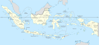
Papua is a province of Indonesia, comprising the northern coast of Western New Guinea together with island groups in Cenderawasih Bay to the west. It roughly follows the borders of Papuan customary region of Tabi Saireri. It is bordered by the sovereign state of Papua New Guinea to the east, the Pacific Ocean to the north, Cenderawasih Bay to the west, and the provinces of Central Papua and Highland Papua to the south. The province also shares maritime boundaries with Palau in the Pacific. Following the splitting off of twenty regencies to create the three new provinces of Central Papua, Highland Papua, and South Papua on 30 June 2022, the residual province is divided into eight regencies and one city (kota), the latter being the provincial capital of Jayapura. The province has a large potential in natural resources, such as gold, nickel, petroleum, etc. Papua, along with five other Papuan provinces, has a higher degree of autonomy level compared to other Indonesian provinces.

<span class="mw-page-title-main">Provinces of Indonesia</span> First-level administrative divisions of Indonesia

Provinces are the first-level administrative divisions of Indonesia. It is formerly called the first-level provincial region before the Reform era. Provinces have a local government, consisting of a governor and a regional legislative body. The governor and members of local representative bodies are elected by popular vote for five-year terms, but governors can only serve for two terms. Provincial governments have the authority to regulate and manage their own government affairs, subject to the limits of the central government.

<span class="mw-page-title-main">West Papua (province)</span> Province in Indonesia

West Papua, formerly Irian Jaya Barat, is an Indonesian province located in Indonesia Papua. It covers most of the two western peninsulas of the island of New Guinea, the eastern half of the Bird's Head Peninsula and the whole of the Bomberai Peninsula, along with nearby smaller islands. The province is bordered to the north by the Pacific Ocean, to the west by Southwest Papua Province, the Halmahera Sea and the Ceram Sea, to the south by the Banda Sea, and to the east by the province of Central Papua and the Cenderawasih Bay. Manokwari is the province's capital and largest city. With an estimated population of 569,570 in mid-2023, West Papua is the least populous province in Indonesia after South Papua, following the separation off in 2022 of the western half of the Bird's Head Peninsula to create the new province of Southwest Papua, containing 52% of what had been West Papua's population.

<span class="mw-page-title-main">Bird's Head Peninsula</span> Peninsula in Indonesia

The Bird's Head Peninsula or Doberai Peninsula, is a large peninsula that makes up the northwest portion of the island of New Guinea, comprising the Indonesian provinces of Southwest Papua and West Papua. It is often referred to as The Vogelkop, and is so named because its shape looks like a bird's head on the island of New Guinea. The peninsula at the opposite end of the island is called the Bird's Tail Peninsula. The peninsula just to the south is called the Bomberai Peninsula.

<span class="mw-page-title-main">Sorong</span> City and capital of Southwest Papua, Indonesia

Sorong is the largest city and the capital of the Indonesian province of Southwest Papua. The city is located on the western tip of the island of New Guinea with its only land borders being with Sorong Regency. It is the gateway to Indonesia's Raja Ampat Islands, species rich coral reef islands in an area considered the heart of the world's coral reef biodiversity. It also is the logistics hub for Indonesia's thriving eastern oil and gas frontier. Sorong experienced rapid growth during the decade from 2010, and further growth is anticipated as Sorong becomes linked by road to other frontier towns in Papua's Bird's Head Peninsula. The official estimate of population as at mid 2023 was 294,978 - comprising 154,543 males and 140,435 females. The suburban area of Sorong city contains tropical rainforest and mangrove forest that has increasingly become popular as ecotourism attractions especially for birdwatching or wildlife watching.

<span class="mw-page-title-main">Raja Ampat Islands</span> Archipelago in Southwest Papua, Indonesia

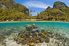
Raja Ampat, or the Four Kings, is an archipelago located off of the northwest tip of Bird's Head Peninsula, Southwest Papua province, Indonesia. It comprises over 1,500 small islands, cays, and shoals around the four main islands of Misool, Salawati, Batanta, and Waigeo, and the smaller island of Kofiau.

<span class="mw-page-title-main">Sorong Regency</span> Regency in Southwest Papua, Indonesia

Sorong Regency is a regency of the Southwest Papua province of Indonesia. It covers an area of 13,075.28 km2, and had a population of 70,619 at the 2010 Census, and 118,679 at the 2020 Census; the official estimate as of mid-2023 was 129,963. Its administrative centre is the town of Aimas. Sorong Regency surrounds Sorong City (Kota) on the landward side; the city is administratively independent of the Regency and is not included in the above statistics; Sorong City has an airport, Sorong Airport, which also serves the Regency.

<span class="mw-page-title-main">Misool</span> Island in Indonesia

Misool, formerly spelled Mysol or Misol, is one of the four major islands in the Raja Ampat Islands in Southwest Papua, Indonesia. Its area is 2,034 km2. The highest point is 561 m and the main towns are Waigama, located on the island's northwest coast, and Lilinta on the island's southeast coast.

<span class="mw-page-title-main">Salawati</span> Island in Indonesia

Salawati is one of the four major islands in the Raja Ampat Islands in Southwest Papua, Indonesia. Its area is 1,623 km2. Salawati is separated from New Guinea to the southeast by the Sele Strait, and from Batanta to the north by the Pitt Strait.

<span class="mw-page-title-main">Maybrat Regency</span> Regency in Southwest Papua, Indonesia

Maybrat Regency is a regency of Southwest Papua Province of Indonesia. It has an area of 5,461.69 km2 (2,108.77 sq mi), and had a population of 33,081 at the 2010 Census and 42,991 at the 2020 Census; the official estimate as at mid 2023 was 46,287. The administrative centre is the town of Kumurkek, in Aifat District. The Maybrat language is spoken in the regency.

<span class="mw-page-title-main">Raja Ampat Regency</span> Regency in Southwest Papua, Indonesia

Raja Ampat Regency is a regency of Southwest Papua Province of Indonesia. The regency, which was formed by separating the archipelago from Sorong Regency, based on the Law 26 of 2002, was inaugurated on 12 April 2003. It consists of a number of groups of islands situated off the north-west end of West Papua; the four main islands from south to north are Misool, Salawati, Batanta, and Waigeo. At present, the regency covers a land area of 7,559.60 km2, with a total area stated as 67,379.61 km2. It had a population of 42,508 at the 2010 Census and 64,141 at the 2020 Census; the official estimate as at mid 2023 was 68,501. The principal town lies at Waisai on Waigeo Island.

<span class="mw-page-title-main">Tambrauw Regency</span> Regency in Southwest Papua, Indonesia

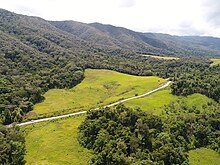
Tambrauw Regency is a regency of Southwest Papua Province, Indonesia, in the Bird's Head Peninsula of Papua Island. It was created on 29 October 2008 from what had been an eastern part of Sorong Regency, originally as part of the province of West Papua. Much of the regency is located on the Tamrau Mountains that the local government declarated Tambrauw as a "conservation regency".

<span class="mw-page-title-main">Doom Island</span> Island in Southwest Papua, Indonesia

Doom Island is a small island in Southwest Papua, Indonesia. It is administratively part of the city of Sorong, specifically the Sorong Islands District.

This is a list of emblems or coat of arms used in Indonesia. Indonesia is divided into 38 provinces, and each province is divided into regencies (kabupaten) and cities (kota). There are 416 regencies and 98 cities. Each province, regency, and city has its own emblem.

<span class="mw-page-title-main">Central Papua</span> Province in Indonesia

Central Papua, officially the Central Papua Province is an Indonesian province located in the central region of Western New Guinea. It was formally established on 11 November 2022 from the former eight western regencies of the province of Papua. It covers an area of 61,072.91 km2 and had an officially estimated population of 1,452,810 in mid 2023. It is bordered by the Indonesian provinces of West Papua to the west, the province of Papua to the north and northeast, by Highland Papua to the east, and by South Papua to the southeast. The administrative capital is located in Wanggar District in Nabire Regency, although Timika is a larger town.

The Salawati Kingdom is the Islamic kingdom that once stood in Salawati Island, Raja Ampat Regency, Southwest Papua. The center of the Salawati kingdom was located in the Samate village which is currently located in the North Salawati district.

The province of Southwest Papua in Indonesia is divided into regencies. The regencies are turn are divided administratively into districts, also known in Indonesian as distrik or kecamatan.

References

  1. 1 2 3 "Visualisasi Data Kependudukan – Kementerian Dalam Negeri 2022" (visual). www.dukcapil.kemendagri.go.id. Retrieved 31 July 2022.
  2. 1 2 Badan Pusat Statistik, Jakarta, 2023, Provinsi Papua Barat Daya Dalam Angka 2023 (Katalog-BPS 1102001.92)
  3. Paramadwya, Adryan Yoga (17 November 2022). Widiantoro, Wisnu (ed.). "DPR Sahkan RUU Pembentukan Papua Barat Daya". kompas.id (in Indonesian). Retrieved 17 November 2022.
  4. Ruhmana, Uma (1 September 2022). "Tim Percepatan Pemekaran Tegaskan Cakupan Wilayah dan Letak Ibukota Calon Provinsi Papua Barat Daya". jagaindonesia.com.
  5. "Pemekaran Wilayah Papua & Papua Barat". cnnindonesia.com. Retrieved 6 May 2021.
  6. Puspita, Ratna (ed.). "Gubernur Papua Barat Dorong Pemekaran Papua Barat Daya". republika.co.id. Retrieved 6 May 2021.
  7. Farisa, Fitria Chusna, ed. (17 November 2022). "Sah! Indonesia Kini Punya 38 Provinsi, Ini Daftarnya". KOMPAS.com (in Indonesian). Jakarta: Kompas Cyber Media. Retrieved 17 November 2022.
  8. 1 2 "Kawasan Konservasi Perairan di Raja Ampat". kkprajaampat.com. BLUD UPTD Pengelolaan Kawasan Konservasi Perairan di Raja Ampat. Retrieved 17 November 2022.
  9. Majid, Abdul (1 May 2021). "Raja Ampat, Surga Penyelam dari Timur Indonesia". detik.com. Retrieved 17 November 2022.
  10. Nauly, Yacob (27 February 2021). "Usia 21 Tahun, Kota Sorong Termaju Di Tanah Papua". suarakarya.id.
  11. 1 2 "Kaya Akan Keindahan Alam, Tambrauw Perlu Kedepankan Konservasi". Kementerian Pariwisata dan Ekonomi Kreatif. 23 August 2020.
  12. 1 2 Nugroho, Hari; Awal, Riyanto; Wantoro, Sigit; Yessi, Santika; Irham, Muhammad (2020). Ekspedisi Tambrauw: Sepotong Surga di Tanah Papua (in Indonesian). Jakarta: LIPI Press. ISBN   978-602-496-059-9. OCLC   1160197476.
  13. Wanggai, Tony V.M. (2008). Rekonstruksi Sejarah Islam di Tanah Papua (PDF) (Thesis) (in Indonesian). UIN Syarif Hidayatullah. Retrieved 30 January 2022.
  14. Mansoben, Johszua Robert (1995). Sistem Politik Tradisional Di Irian Jaya. Jakarta: LIPI - RUL 1995. pp. 242–246. ISBN   979-8258-06-1.
  15. Swadling, Pamela; Wagner, Roy; Laba, Billai (1 December 2019). Plumes from paradise: trade cycles in outer Southeast Asia and their impact on New Guinea and nearby islands until 1920. Sydney University Press. p. 17. doi:10.30722/sup.9781743325445. ISBN   978-1-74332-544-5. OCLC   988941308. S2CID   240917675.
  16. Bone, Robert (1958). THE DYNAMICS OF THE WESTERN NEW GUINEA (IRIAN BARAT) PROBLEM. Ithaca, NY: Cornell University.
  17. Poulgrain, Greg (1999). "Delaying the 'Discovery' of Oil in West New Guinea". The Journal of Pacific History. 34 (2). Taylor & Francis Ltd.: 205–218. doi:10.1080/00223349908572903. JSTOR   25161079.
  18. 1 2 Genthong, Aryo Wisanggeni (4 August 2008). "Menelusuri Kota Tua Ala Belanda". kompas.com. Retrieved 19 November 2022.
  19. Parera, Ana, M.F.; Usmany, Desy; Saberia, Saberia; Sinaga, Rosmaida (2013). Sausapor Saksi Sejarah Perang Dunia II di Kabupaten Tambrauw Provinsi Papua Baral. Yogyakarta: Kepel Press. ISBN   978-602-1228-12-8.{{cite book}}: CS1 maint: multiple names: authors list (link)
  20. Patiara, John; Renwarin, Herman; Soedharto, Bondan; Palangan, M. (1983). "Sejarah Perlawanan Terhadap Imperialis dan Kolonialisme di Daerah Irian Jaya" (PDF). Kemdikbud. p. 81. Retrieved 18 January 2023.
  21. 25 tahun Trikora (in Indonesian). Yayasan Badan Kontak Keluarga Besar Perintis Irian Barat. 1988. pp. 96–109. Retrieved 1 November 2021 via Google Play Books.
  22. Patiara, John; Renwarin, Herman; Soedharto, Bondan; Palangan, M. (1983). "Sejarah Perlawanan Terhadap Imperialis dan Kolonialisme di Daerah Irian Jaya" (PDF). Kemdikbud. pp. 91–99. Retrieved 3 November 2021.
  23. 25 tahun Trikora (in Kinyarwanda). Yayasan Badan Kontak Keluarga Besar Perintis Irian Barat. 1988. pp. 164–167. Retrieved 1 November 2021 via Google Play Books.
  24. UU Nomor 12 Tahun 1969
  25. Inayah, Hidayati (2018). "Migrasi Penduduk ke Kota Sorong". BRIN – LIPI.
  26. "Sejarah Singkat". sorongkota.go.id. Pemerintah Kota Sorong.
  27. Suryawan, I. Ngurah (2022). "Terbentuknya "Kelompok Mencari": Dinamika Jaringan Perantara (Brokerage) dalam Pemekaran Daerah Papua Barat Daya". Jurnal Ilmiah Hubungan Internasional (edisi khusus papua). Unpar: 67–81. doi: 10.26593/jihi.v0i00.5971.67-81 . S2CID   251088248.
  28. "Akhir dari Perjuangan 20 Tahun Terbentuk Provinsi Papua Barat Daya". Serambinews.com (in Indonesian). 18 November 2022. Retrieved 22 November 2022.
  29. "Ada Waktu Ayamaru, Aitinyo, Aifat (A3) Adakan Rekonsiliasi". monitorpapua.com. 10 March 2018. Retrieved 19 November 2022.
  30. Cahyu (27 September 2018). "Ibu Kota Maybrat Berpindah dari Ayamaru ke Kumurkek". Liputan6. Retrieved 19 November 2022.
  31. "Disepakati 11 Distrik Pemekaran dari 4 Distrik Di Tambrauw Dikembalikan Ke Manokwari". jagatpapua.com. 8 September 2022. Retrieved 19 November 2022.
  32. Akbar, Nawir Arsyad (31 August 2022). Raharjo, Agus (ed.). "RUU Papua Barat Daya Ungkap Praktik Pinjam Distrik untuk Pilkada". republika.co.id.
  33. "Kirab Pemilu 2024 di Sorong Selatan, Ulik Potensi Udang dan Kepiting". kompas.id. KOMPAS. 12 November 2023. Retrieved 13 February 2024.
  34. Dhani, Arya Kusuma (6 November 2018). "RIMBUNNYA HUTAN MANGROVE SORONG SELATAN MENJADI SARANA MASYARAKAT UNTUK BERBURU RUPIAH". wwf.id. WWF - INDONESIA.
  35. Setiawan, Azhari (25 October 2021). "Menparekraf Tinjau Taman Wisata Mangrove Klawalu Pertama di Tanah Papua". kemenparekraf.go.id. Kementerian Pariwisata dan Ekonomi Kreatif.
  36. Smur, Jembris; Rusim, Dewi Ana; Manalu, Janviter (2021). "ANALISIS FAKTOR PENYEBAB DAN STRATEGI PENGENDALIAN KEKERINGAN DANAU AYAMARU KABUPATEN MAYBRAT". Jurnal ELIPS (Ekonomi, Lingkungan, Infrastruktur, Pengembangan Wilayah dan Sosial Budaya). 4 (1). Universitas Cenderawasih.
  37. Hakim, Rahman (22 March 2023). "Berwisata di Papua Barat Daya, Coba Kunjungi Danau Ayamaru di Kab Maybrat yang Miliki Air Jernih". sorong.tribunnews.com.
  38. Ambari, M. (20 August 2019). "Aneka Potensi dari Kawasan Pulau Terluar Samudera Pasifik". mongabay.co.id. MONGABAY.
  39. Firdaus, Haris (10 January 2022). "Sawit Ditolak, Terbitlah Jagung". kompas.id. KOMPAS.
  40. Ambari, M. (5 February 2018). "Pelindung Penyu dari Kepunahan itu Bernama Taman Pesisir Jeen Womom". mongabay.co.id. MONGABAY.
  41. Biro Pusat Statistik, Jakarta, 2011.
  42. Badan Pusat Statistik, Jakarta, 2021.
  43. "[Metode Baru] Indeks Pembangunan Manusia Menurut Kabupaten/Kota 2021-2023". papuabarat.bps.go.id.
  44. Undang-Undang Nomor 56 Tahun 2008 tentang Pembentukan Kabupaten Tambrauw di Provinsi Papua Barat (Law Number 56 of 2008 regarding the Formation of Tambrauw Regency in West Papua Province). In Indonesian.
  45. Jakarta Post, 14 November 2013
  46. "Jumlah Penduduk Menurut Agama" (in Indonesian). Ministry of Religious Affairs. 31 August 2022. Retrieved 29 October 2023. Muslim 241 Million (87), Christianity 29.1 Million (10.5), Hindu 4.69 million (1.7), Buddhist 2.02 million (0.7), Folk, Confucianism, and others 192.311 (0.1), Total 277.749.673 Million
  47. "Wilayah Kerja - Jerat Papua". www jeratpapua.org (in Indonesian). Retrieved 22 December 2022.
  48. Syaufi, Muhammad (17 May 2022). "Wali Kota dan Bupati Sorong Dukung Mubes Masyarakat Adat Moi". matapapua.com.
  49. "Pokja Adat MRPB Resmikan 9 Sub Suku dan Lantik Sub Suku Maybrat". suaraindonesia-news.com (in Indonesian). Retrieved 21 December 2022.
  50. "Gelandang Timnas Ricky Kambuaya Dihadiahi Sepeda Motor". www.cnnindonesia.com (in Indonesian). Retrieved 21 December 2022.
  51. Mansoben, Johszua Robert (1995). Sistem Politik Tradisional Di Irian Jaya. Jakarta: LIPI - RUL 1995. pp. 229–231. ISBN   979-8258-06-1.
  52. Damarjati, Danu (29 October 2019). "Mengenal Tujuh Wilayah Adat Papua yang Jadi Dasar Pemekaran". news.detik.com (in Indonesian). Retrieved 21 December 2022.
  53. "Suku Kokoda, Suku Muslim di Papua Barat". suaramuslim.net (in Indonesian). Retrieved 21 December 2022.
  54. "Peta Bahasa Provinsi Papua Barat". Bahasa dan Peta Bahasa di Indonesia. Retrieved 22 December 2022.
  55. "Pangkalan Data Pendidikan Tinggi". pddikti.kemdikbud.go.id/. Kementerian Pendidikan dan Kebudayaan.
  56. "Kampus III UNIPA Prodi D3 Ekowisata Gelar Wisuda Perdana". sorongnews.com. 31 March 2021. Retrieved 20 January 2023.
  57. "Fakultas Kehutanan melebarkan sayap dengan membuka program studi Ksda di Kabupaten Tambrauw". unipa.ac.id. 19 October 2022. Retrieved 20 January 2023.
  58. "Top 1000 sekolah Tahun 2022 Berdasarkan Nilai UTBK". ltmpt.ac.id. Lembaga Tes Masuk Perguruan Tinggi. Archived from the original on 26 November 2022.
  59. Kusnandar, VIva Budy (16 September 2022). "Hanya ada 2 SMA dari Papua yang Masuk Top 1.000 Sekolah Terbaik". katadata.co.id. Retrieved 7 December 2022.
  60. Maichel (9 May 2023). "KEK Sorong Tak Optimal Tarik Investor, Ini Langkah Pemprov Papua Barat Daya". kompas.com. Archived from the original on 25 May 2023. Retrieved 16 May 2023.
  61. Pratiwi, Fuji (19 August 2022). "Gag Nikel Berencana Tambah Kapasitas Produksi Jadi 4 Juta Wmt". republika.co.id. Republika. Archived from the original on 16 May 2023. Retrieved 16 May 2023.
  62. Pabika, Agus (22 September 2023). "Menjual Surga Demi Ambisi Investasi EV di Pulau Gag Raja Ampat". suarapapua.com.
  63. "PTUN Tolak Perusahaan Sawit Sorong, Tanah Kembali ke Masyarakat Adat". CNN Indonesia. 12 January 2022. Archived from the original on 16 May 2023. Retrieved 16 May 2023.
  64. "PJ GUBERNUR PAPUA BARAT DAYA KUNJUNGI ANJAP, DORONG PENGEMBANGAN SAGU UNTUK MENJADI PRIORITAS DAERAH". anj-group.com. ANJ Group. 25 January 2024.
  65. "PENGELOLAAN HUTAN BERKELANJUTAN : SAGU PAPUA, SUMBER PANGAN BERKELANJUTAN". perpustakaan.menlhk.go.id. Kementerian Lingkungan Hidup dan Kehutanan. 2018. Retrieved 14 February 2024.
  66. "PERATURAN DAERAH KABUPATEN TAMBRAUW NOMOR 5/36 TAHUN 2018 TENTANG KABUPATEN TAMBRAUW SEBAGAI KABUPATEN KONSERVASI". Pemerintah Kabupaten Tambrauw.
  67. 1 2 3 Ferdinandus, Hadi (31 July 2019). "Taman Pesisir Jeen Womom Lakukan Sasi". WWF.
  68. Fatem, Sepus, M.; Asem, Gabriel (2015). "Kabupaten Konservasi Sebagai Political Action Pemerintah Daerah Dalam Mendukung Konservasi Sumberdaya Alam Hayati: Studi Kasus Kabupaten Tambrauw, Papua Barat". Prosiding Seminar Nasional Masyarakat Biodiversitas Indonesia. 1 (6). SMUJO. doi: 10.13057/psnmbi/m010624 . ISSN   2407-8050.{{cite journal}}: CS1 maint: multiple names: authors list (link)
  69. Montesori, Jeis (3 July 2022). "Mantan Bupati Tambrauw: Jaga Hutan Adat untuk Kemaslahatan Orang Papua". beritasatu.com.