Kent, New York

Last updated

Kent, New York
Town of Kent
ISeven Hills Lake.JPG
Seven Hills Lake
Kent, NY Seal.png
Putnam County New York incorporated and unincorporated areas Kent highlighted.svg
Location of Town of Kent, New York
Coordinates: 41°28′N73°41′W / 41.467°N 73.683°W / 41.467; -73.683
Country United States
State New York
County Putnam
Government
   Supervisor Jaime McGlasson
Area
[1]
  Total43.33 sq mi (112.21 km2)
  Land40.50 sq mi (104.90 km2)
  Water2.82 sq mi (7.31 km2)
Elevation
610 ft (186 m)
Population
 (2020)
  Total12,900
  Estimate 
(July 2021) [2]
12,922
  Density327.94/sq mi (126.62/km2)
Time zone UTC-5 (Eastern (EST))
  Summer (DST) UTC-4 (EDT)
ZIP code
10512
Area code 845
FIPS code 36-39331
GNIS feature ID0979740
Website www.townofkentny.gov

Town of Kent is a town in Putnam County, New York, United States. The population was 12,900 at the 2020 census. [3] The name is that of an early settler family. The town is in the north-central part of the Putnam County. Many of the lakes are reservoirs for New York City.

Contents

History

Kent was part of the Philipse Patent of 1697, when it was still populated by the Wappinger tribe. Daniel Nimham (1724–1778) was the last chief of the Wappingers and was the most prominent Native American of his time in the Hudson Valley.

The town was first settled by Europeans in the mid-18th century by Zachariah Merritt and others, from New England, Westchester County, or the Fishkill area. Elisha Cole and his wife Hannah Smalley built Coles Mills in 1748, having moved to that location the previous year from Cape Cod. [4] Coles Mill operated until 1888 when it was submerged under West Branch Reservoir. Around this same time the northeastern part of the county was settled by the Kent, Townsend, and Ludington families, among others. The father of Hannah Smalley and his family moved to Kent about two years before Elisha Cole and his family. [5]

Kent was a part of the Frederickstown Precinct which was chartered in 1772, the rest of Frederickstown consisting of the future town of Carmel and the western parts of the future towns of Patterson and Southeast. Other early family names were Townsend, Smalley, Kent, Dykeman, Barrett, Cole, Boyd, Wixon, Farrington, Burton, Carter, and Ludington. [6]

The present-day intersection of Interstate 84 and Ludingtonville Road was the home of Col. Henry Ludington and his daughter Sybil, who was said to have ridden 40 miles (64 km) one night in 1777 to call up her father's militia during the American Revolutionary War. A statue of her stands on the shores of Lake Gleneida across from the Putnam County Courthouse.

When the towns of Carmel and Patterson were split from Frederickstown in 1795, the remnant, constituting the current Kent, was established as the "Town of Frederick". Until 1812 it was part of Dutchess County. The town's name was changed to "Kent" in 1817. A small portion of the town of Philipstown was transferred to Kent in 1877.

The major population center of the township is Lake Carmel, a settlement around an artificial lake of the same name developed in the 1920s. Historically the population centers had been Farmer's Mills and Luddingtonville, little of which remain, and Cole's Mills, none of which remains.

Much of early Kent's economy was based on dairy farming for the New York City market, but with many reservoirs being constructed in the late 19th century for drinking water for the same city, most of the farms were submerged, and the dairy industry was all but abandoned by the 1920s. At that point, and because of the advent of the automobile, Kent started to attract new residents from the city.

The town is served by the Carmel Central School District and, for the majority of residents, by the Carmel Post Office. Kent is home to the 82.5-foot-tall (25.1 m) Nimham Mountain Fire Tower, located in the Taconic Hills. Built by the State of New York and the CCC in 1940, it is the tallest remaining fire tower in New York state and appears on the National Historic Lookout Register. The Chuang Yen Monastery which is home to the largest indoor statue of Buddha in the Western Hemisphere is also located in Kent.

Geography

In spite of its name, Lake Carmel lies in Kent Lake Carmel, New York.jpg
In spite of its name, Lake Carmel lies in Kent

Kent is rugged and hilly, sitting atop the interior ridges of the Hudson Highlands some 60 miles (97 km) north of New York City in the north central portion of Putnam County. It borders the towns of Philipstown and Putnam Valley to the west and southwest; Patterson to the east, and Carmel to the south. The northern town line is the border of the Dutchess County towns of East Fishkill and Pawling. Two state parks, Wonder Lake [ citation needed ] in the east and Fahnestock in the west, a portion of the Appalachian National Scenic Trail, and thousands of acres of open space under the permanent protection of the New York City Department of Environmental Protection, offer recreational opportunities.

Canopus Lake in Clarence Fahnestock Memorial State Park Canopus Lake, Fahnestock State Park, NY.jpg
Canopus Lake in Clarence Fahnestock Memorial State Park

The town is home to a number of lakes which were once popular with summer residents but now have become year-round communities, including Sagamore Lake, Kentwood Lake, Lake Tibet, China Lake, Palmer Lake, and White Pond. Kent is also home to two reservoirs that are part of the New York City water supply system, with much adjacent land purchased by it for conservation through the Watershed Preservation Program.[ clarification needed ] These include Boyds Corner and West Branch, with the latter being the east-of-Hudson terminus of the important Catskill/Delaware supply.

Interstate 84 and the Taconic State Parkway pass through the town.

Demographics

Historical population
CensusPop.Note
1820 1,801
1830 1,9287.1%
1840 1,830−5.1%
1850 1,557−14.9%
1860 1,479−5.0%
1870 1,5474.6%
1880 1,361−12.0%
1890 1,147−15.7%
1900 1,026−10.5%
1910 968−5.7%
1920 696−28.1%
1930 77010.6%
1940 1,546100.8%
1950 2,14638.8%
1960 3,92482.9%
1970 8,106106.6%
1980 12,43353.4%
1990 13,1836.0%
2000 14,0096.3%
2010 13,507−3.6%
2016 (est.)13,283 [2] −1.7%
U.S. Decennial Census

As of the census [7] of 2000, there were 14,009 people, 4,868 households, and 3,748 families residing in the town. The population density was 344.8 inhabitants per square mile (133.1/km2). There were 5,353 housing units at an average density of 131.8 units per square mile (50.9 units/km2). The racial makeup of the town was 93.81% white, 1.41% African American, .14% Native American, 1.24% Asian, .01% Pacific Islander, 1.81% from other races, and 1.57% from two or more races. Hispanic or Latino of any race were 5.77% of the population.

There were 4,868 households, out of which 38.3% had children under the age of 18 living with them, 64.4% were married couples living together, 9.0% had a female householder with no husband present, and 23.0% were non-families. 17.5% of all households were made up of individuals, and 4.8% had someone living alone who was 65 years of age or older. The average household size was 2.84 and the average family size was 3.24.

In the town, the population was spread out, with 26.3% under the age of 18, 6.2% from 18 to 24, 32.1% from 25 to 44, 25.7% from 45 to 64, and 9.7% who were 65 years of age or older. The median age was 38 years. For every 100 females, there were 98.4 males. For every 100 females age 18 and over, there were 96.2 males.

The median income for a household in the town was $72,346, and the median income for a family was $79,716. Males had a median income of $51,634 versus $38,575 for females. The per capita income for the town was $29,984. About 4.2% of families and 4.1% of the population were below the poverty line, including 4.6% of those under age 18 and 8.4% of those age 65 or over.

Government

The town of Kent is governed by a town board which meets at a town hall in the hamlet of Kent Lakes. Laws are primarily enforced by officers of the town's police department.

Communities and locations in Kent

The Chuang Yen Monastery (Zhuang Yan Si ) houses the largest indoor statue of Buddha in the Western Hemisphere Chuang Yen Monastery 2004.jpeg
The Chuang Yen Monastery (莊嚴寺) houses the largest indoor statue of Buddha in the Western Hemisphere

Notable people

Related Research Articles

<span class="mw-page-title-main">Putnam County, New York</span> County in New York, United States

Putnam County is a county located in the U.S. state of New York. As of the 2020 census, the population was 97,668. The county seat is Carmel. Putnam County was formed in 1812 from Dutchess County and is named for Israel Putnam, a hero in the French and Indian War and a general in the American Revolutionary War.

<span class="mw-page-title-main">Russia, New York</span> Town in New York, United States

Russia is a town in Herkimer County, New York, United States. The population was 2,587 at the 2010 census. The town is located in the northwestern part of the county and is northeast of Utica.

<span class="mw-page-title-main">Forestport, New York</span> Town in New York, United States

Forestport is a town in Oneida County, New York, United States. The population was 1,535 at the 2010 census.

Hopewell is a town in Ontario County, New York, United States. The population was 3,841 at the 2020 census.

<span class="mw-page-title-main">Carmel, New York</span> Town in New York, United States

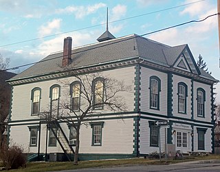
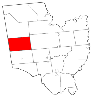
Carmel is a town in Putnam County, New York, United States. As of the 2020 United States census, the town had a population of 33,576. The town may have been named after Mount Carmel in Israel.

<span class="mw-page-title-main">Carmel Hamlet, New York</span> Hamlet and Census-designated place in New York, United States

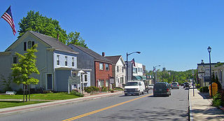
Carmel Hamlet, commonly known simply as Carmel, is a hamlet and census-designated place (CDP) located in the Town of Carmel in Putnam County, New York, United States. As of the 2010 census, the population was 6,817.

<span class="mw-page-title-main">Lake Carmel, New York</span> Census-designated place in New York, United States

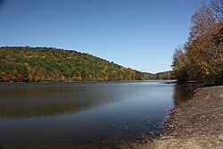
Lake Carmel is a hamlet and census-designated place in the town of Kent in Putnam County, New York, United States. The home of over half of the town of Kent's population of 8,282, the hamlet is centered around Lake Carmel, a 1.6 mile long manmade lake in the southeastern corner of the township and just north of hamlet of Carmel within the town of Carmel.

<span class="mw-page-title-main">Mahopac, New York</span> Census-designated place & hamlet in New York, United States

Mahopac is a hamlet in the town of Carmel in Putnam County, New York, United States. Also known as Lake Mahopac, the exurb is located some 47 miles (76 km) north of New York City, on US Route 6 at the county's southern central border with Westchester County. As of the 2020 census, the population was 8,933.

<span class="mw-page-title-main">Patterson, New York</span> Town in New York, United States

Patterson is a town in Putnam County, New York, United States. The town is in the northeastern part of the county. Interstate 84 passes through the southwestern section of the town. The population was 11,541 at the 2020 census. The town is named after early farmer Matthew Paterson. The reason Patterson was spelled with two "t"s was due to the looseness with which Paterson spelled his own last name.

<span class="mw-page-title-main">Philipstown, New York</span> Town in New York, United States

Philipstown is a town located in the western part of Putnam County, New York, United States. The population was 9,831 at the 2020 census.

<span class="mw-page-title-main">Southeast, New York</span> Town in New York, United States

Southeast is a town in Putnam County, New York, United States, so named for its location in the southeastern corner of the county. The population was 18,058 at the 2020 census. The town as a whole is informally referred to as Brewster, the town's principal settlement; the latter is also an incorporated village within the town's borders. Interstate 84, Interstate 684, U.S. Route 202, US Route 6, and NY 22 are the primary routes through the town.

<span class="mw-page-title-main">Providence, New York</span> Town in New York, United States

Providence is a town in Saratoga County, New York, United States. The Town of Providence is on the county's western border and is northwest of Saratoga Springs. More than half the town is located within the Adirondack Park, the town also borders the Great Sacandaga Lake.

<span class="mw-page-title-main">Gilboa, New York</span> Town in New York, United States

Gilboa is a town in Schoharie County, New York, United States. The population was 1,111 at the 2020 census.

<span class="mw-page-title-main">Colton, New York</span> Town in New York, United States

Colton is a town in St. Lawrence County, New York, United States. The population was 1,451 at the 2010 census. The town, originally named "Matildaville", is named after early settler Jesse Colton Higley.

<span class="mw-page-title-main">Putnam, New York</span> Town in Washington County, New York, US

Putnam is a town in northern Washington County, New York, United States. It is part of the Glens Falls Metropolitan Statistical Area. The town population was 645 at the 2000 census. The town is named after Israel Putnam, a hero of the American Revolution.

<span class="mw-page-title-main">Mayfield, New York</span> Town in New York, United States

Mayfield is a town in Fulton County, New York, United States, northeast of Gloversville and Johnstown. The town contains a village also named Mayfield. The population of the town was 6,495 at the 2010 census.

<span class="mw-page-title-main">Croghan, New York</span> Town in New York, United States

Croghan is a town in Lewis County, New York, United States. The population was 3,093 at the 2010 census. The town is in the northern part of the county and located northeast of the county seat, Lowville. The town contains a village also named Croghan, a small part of which is located in the adjacent town of New Bremen. Both the village and town are locally pronounced \Krō-gun\.

<span class="mw-page-title-main">New York State Route 301</span> State highway in Putnam County, New York, US

New York State Route 301 (NY 301), also known as the Hudson River Turnpike, is an intra-county state highway stretching across three-quarters of Putnam County, New York, in the United States. The western terminus of NY 301 is at an intersection with NY 9D in Cold Spring. Its eastern terminus is at a junction with NY 52 in Carmel. Along the way, NY 301 meets U.S. Route 9 (US 9) and the Taconic State Parkway and passes through Clarence Fahnestock State Park. The section of the route between NY 9D and US 9 is ceremonially designated as the Sergeant Albert Ireland Memorial Highway.

<span class="mw-page-title-main">Cobleskill, New York</span> Town in New York, United States

Cobleskill is a town in Schoharie County, New York, United States. The population was 6,086 at the 2020 census. The town contains a village, also named Cobleskill, as well as the State University of New York at Cobleskill.

<span class="mw-page-title-main">Coles Mills, New York</span> Prior settlement in New York state

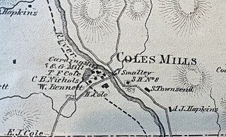
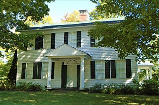
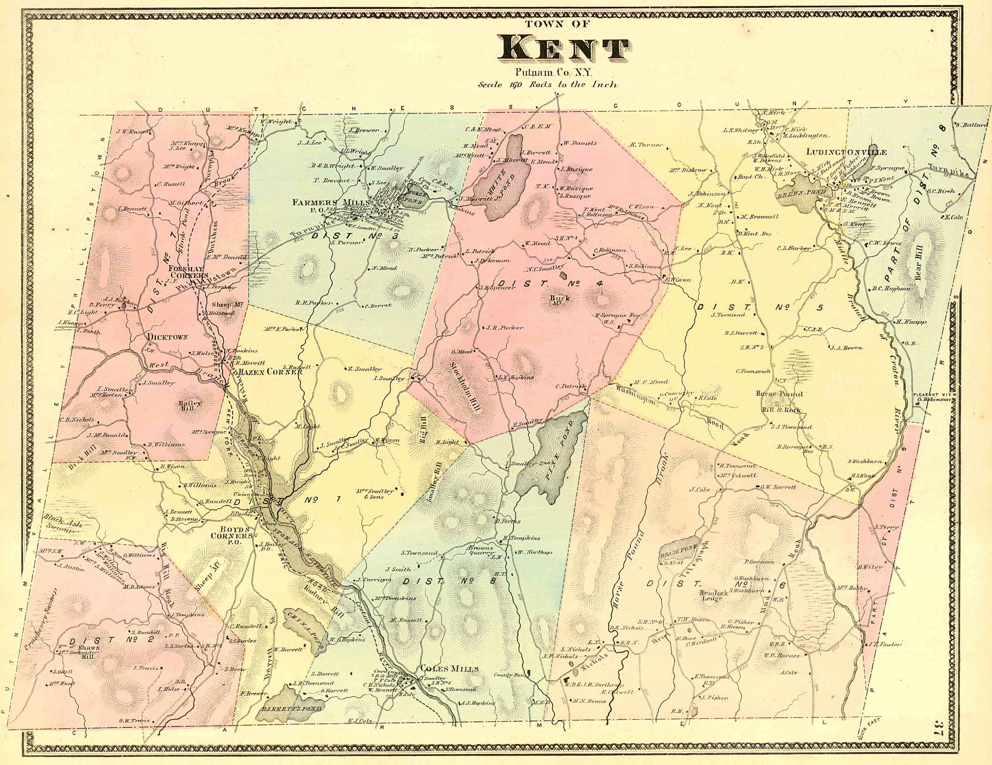
Coles Mills was one of the first settlements in the Southern Precinct of Dutchess County, now Putnam County, in the U.S. State of New York. Cole's Mills features prominently on the 19th Century maps of the area including the 1854 R. F. O’Connor Map of Putnam County, the 1867 F.W. Beers Map, and the United States Geological Survey map from 1892.

References

  1. "2016 U.S. Gazetteer Files". United States Census Bureau. Retrieved July 5, 2017.
  2. 1 2 "Population and Housing Unit Estimates" . Retrieved June 9, 2017.
  3. "U.S. Census Bureau QuickFacts: Kent town, Putnam County, New York". www.census.gov. Retrieved June 8, 2022.
  4. "Search".
  5. "The Descendants of Elisha Cole", compiled by Joseph O. Curtis, 1909
  6. The 1866 Beers map http://www.hyzercreek.com/Kent.jpg
  7. "U.S. Census website". United States Census Bureau . Retrieved January 31, 2008.
  8. "Largest Indoor Buddha in the Western Hemisphere". RoadsideAmerica.com. Retrieved October 27, 2015.
  9. Inc, Time (October 31, 1969). LIFE. Time Inc.{{cite book}}: |last= has generic name (help)

41°28′N73°41′W / 41.467°N 73.683°W / 41.467; -73.683