
The Cannon River a tributary of the Mississippi River flows 112 miles (180 km) from Shields Lake near Shieldsville to Red Wing in the U.S. state of Minnesota, where it joins the Mississippi River. It drains a watershed approximately 1460 square miles (3,780 km²) in size. The river flows through the counties of Le Sueur, Rice, Dakota, and Goodhue.

Lake Bemidji is a small glacially-formed lake, approximately 11 square miles in area, in northern Minnesota in the United States. Located less than 50 miles (80 km) downstream from the source of the Mississippi River, it both receives and is drained by the Mississippi.

Como Lake is a 70.5-acre (285,000 m2) lake up to 15.5 feet (4.7 m) deep in St. Paul, Minnesota, United States. It, along with the neighboring Como Park, has been a recreation area for residents of the Twin Cities for more than a century. It was named in 1848 by local farmer Charles Perry. A pavilion sits on the west side of the lake, and plays host to theatrical performances and concerts during the warmer months. The park features a variety of attractions, including the Como Park Zoo and Conservatory and the Como Regional Park Pool.

Leech Lake is a lake located in north central Minnesota, United States. It is southeast of Bemidji, located mainly within the Leech Lake Indian Reservation, and completely within the Chippewa National Forest. It is used as a reservoir. The lake is the third largest in Minnesota, covering 102,947.83 acres (416.6151 km2) with 195 miles (314 km) of shoreline and has a maximum depth of 156 feet (48 m).

Deep Creek Lake is the largest inland body of water in the U.S. state of Maryland. It covers approximately 3,900 acres (16 km2) and has 69 miles (111 km) of shoreline. Like all lakes in Maryland, it is man-made. The lake is home to a wide variety of aquatic life, such as freshwater fish and aquatic birds. The Wisp ski resort is located nearby.

Lake Vermilion is a shallow freshwater lake in northeastern Minnesota, United States. The Ojibwe originally called the lake Nee-Man-Nee, which means “the evening sun tinting the water a reddish color”. French fur traders translated this to the Latin word Vermilion, which is a red pigment. Lake Vermilion is located between the towns of Tower on the east and Cook on the west, in the heart of Minnesota's Arrowhead Region at Vermilion Iron Range. The area was mined from the late 19th century until the 1960s, and the Soudan Mine operated just south of the lake.

Lake Harriet is a lake in the southwest part of Minneapolis, just south of Bde Maka Ska and north of Minnehaha Creek. The lake is surrounded by parkland as part of the Minneapolis Chain of Lakes. The lake has an area of 335 acres (1.36 km2) and a maximum depth of 85 feet (26 m).

Cedar Lake is a lake in Minneapolis, Minnesota, United States, and part of the city's Chain of Lakes. It is located on the west side of the city, north of Bde Maka Ska and west of Lake of the Isles. The lake is surrounded by parkland, with some easements having been made to private homeowners on the southeast side. The south and west sides border the Cedar-Isles-Dean neighborhood, while the east side borders the Kenwood residential area. The north side is bordered by the Cedar Lake Trail and the BNSF Railway. Cedar Lake has an area of 169 acres (0.68 km2) and a maximum depth of 51 feet (16 m). Minneapolis Park and Recreation Board manages parkland around the lake.

Red Lake is a lake in Beltrami County in northern Minnesota.

Rock Creek State Park is a state park of Iowa, US. It is located in Jasper County, near Kellogg.
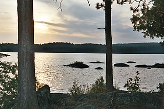
Burntside Lake is a 7,139-acre (28.89 km2) lake, located 3 miles (4.8 km) northwest of Ely, Minnesota, in Saint Louis County, Minnesota. Its western boundary adjoins the Boundary Waters Canoe Area Wilderness on Tamarack Creek.
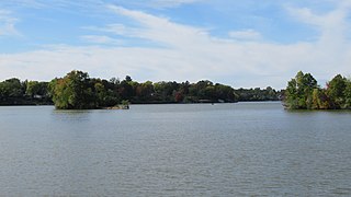
Belleville Lake is a fresh water artificial reservoir located mostly within Wayne County in the U.S. state of Michigan. A very small portion extends west into Washtenaw County. The lake was created from the construction of the French Landing Dam and Powerhouse along the Huron River in 1925.
Libby is an unincorporated community in Libby Township, Aitkin County, Minnesota, United States. The community is located between McGregor and Jacobson along State Highway 65. The Mississippi River flows nearby. Libby is located immediately northwest of Big Sandy Lake.
Green Lake is a lake in Chisago City, Minnesota, United States. This lake is sometimes also referred to as "Big Green Lake" because it is connected to Little Green Lake by a channel. Green Lake was named from the fact its waters are green from the high algae content.

Amelia Lake is a lake in Pope County, Minnesota, United States, located 6.7 miles away from Glenwood. Amelia lake has an elevation of around 1,348 feet (411 m). The lake sits on a lot of 910 acres. The depth of Amelia Lake is 69 feet (21 m) and water clarity can approach 12 feet (3.7 m) during the summer. This lake is open to the public to fish with a proper fishing license.
Crooked Creek is a stream in Houston County, in the U.S. state of Minnesota. Crooked Creek was so named on account of its irregular course.

Medicine Lake is an inland lake located approximately 8 miles northwest of downtown Minneapolis, Minnesota. The lake lies within Hennepin County and is surrounded by two municipalities. At 902 acres, it is Hennepin County's second largest lake behind Lake Minnetonka and is popular among boaters, sailors, and fishers. Medicine Lake's most significant tributary is Plymouth Creek, which enters the lake at West Medicine Lake Park. The lake is also fed by rain and drainage from nearby cities, including Medicine Lake, Plymouth, New Hope, Golden Valley and Minnetonka.


