List of islands of Maryland

Last updated

Maryland has 281 named islands within its many waters and waterways, including the Atlantic ocean; the Chesapeake bay and its many tributary tidal rivers, creeks and bays; as well as within larger whitewater rivers like the upper Potomac.

These Islands are relatively permanent, although some are disappearing on the scale of a few centuries, like Smith Island in the Chesapeake Bay.

There are also a number of unnamed islands in Maryland, many of which are very temporary in nature, lasting only a few years or decades, both in the tidal environment and also in Maryland's larger whitewater rivers. These come and go due to the effect of storms.

This is a list of named islands of Maryland .

Islands of Maryland
CountyIslandRiver/BayType
Anne Arundel County Big Island Rhode River R
Anne Arundel County Brewers Island Marley Creek R
Anne Arundel County Dobbins Island Sillery Bay
Anne Arundel County Flat Island Sellman Creek R
Anne Arundel County Gibson Island Chesapeake Bay
Anne Arundel County Goose Island South River R
Anne Arundel County High Island Rhode River R
Anne Arundel County Little Island Sillery Bay
Anne Arundel County Snake Island Patuxent River R
Anne Arundel County St. Helena Island Little Round Bay
Anne Arundel County The Hammocks Island Main Creek R
Anne Arundel County Three Sisters Islands Chesapeake Bay
Anne Arundel County Turkey Point Island South River R
Anne Arundel County White Rocks Islands Patapsco River R
Baltimore County Carroll Island Gunpowder River R
Baltimore County Hart Island Chesapeake Bay
Baltimore County Hart Miller Island Chesapeake Bay
Baltimore County Hathaway Island Patapsco River R
Baltimore County Pleasure Island Chesapeake Bay
Baltimore County Sue Island Middle River R
Calvert County Solomons Island (formerly Somervell's Island) Patuxent River R
Calvert County Broomes Island Patuxent River R
Calvert County Buzzard Island Patuxent River R
Calvert County Hog Island Chesapeake Bay
Calvert County Ma Leg Island Patuxent River R
Cecil County Garrett Island Susquehanna River R
Cecil County Hen Island Sassafras River R
Cecil County Herring Island Elk River R
Cecil County Indian Rock Island Susquehanna River R
Cecil County Knight Island Sassafras River R
Cecil County Long Island Susquehanna River R
Cecil County Mills Island Susquehanna River R
Cecil County Rough Island Susquehanna River R
Cecil County Rowland Island Susquehanna River R
Cecil County Spencer Island Susquehanna River R
Cecil County Steels Island Susquehanna River R
Cecil County Sterrett Island Susquehanna River R
Charles County Cooksey Island Wicomico River R
Charles County Chopawamsic Island Potomac River R
Charles County Cobb Island Potomac River R
Charles County Craney Island Potomac River R
Charles County Wills Island Port Tobacco River R
Dorchester County Adam Island Holland Straits
Dorchester County Asquith Island Honga River R
Dorchester County Axies Island Nanticoke River R
Dorchester County Barren Island Chesapeake Bay
Dorchester County Bettys Island Blackwater River R
Dorchester County Billys Island Honga River R
Dorchester County Bloodsworth Island Chesapeake Bay
Dorchester County Bull Point Island Meekins Creek R
Dorchester County Cattail Island Chesapeake Bay
Dorchester County Chance Island Transquaking River R
Dorchester County Cherry Island Little Choptank River R
Dorchester County Clay Island Fishing Bay
Dorchester County Dunnock Island Dunnock Slough  ?
Dorchester County Elliott Island Fishing Bay
Dorchester County Grays Island Fishing Bay
Dorchester County Gunners Island Chesapeake Bay
Dorchester County Hog Island Hopper Straits
Dorchester County Holland Island Chesapeake Bay
Dorchester County Hooper Island Chesapeake Bay
Dorchester County James Island Chesapeake Bay
Dorchester County Jenny Island Chesapeake Bay
Dorchester County Langrells Island Nanticoke River R
Dorchester County Long Island Chesapeake Bay
Dorchester County Lower Hooper Island Chesapeake Bay
Dorchester County Middle Hooper Island Chesapeake Bay
Dorchester County Northeast Island Chesapeake Bay
Dorchester County Opossum Island Tar Bay
Dorchester County Pone Island Chesapeake Bay
Dorchester County Poplar Island Fishing Bay
Dorchester County Pot Island Honga River R
Dorchester County Punch Island Chesapeake Bay
Dorchester County Ragged Island Little Choptank River R
Dorchester County Rowland Island Blackwater River R
Dorchester County Sandy Island Nanticoke River R
Dorchester County Sharpes Island Chesapeake Bay
Dorchester County Snake Island Fishing Bay
Dorchester County Spriggs Island Blackwater River R
Dorchester County Spring Island Holland Straits
Dorchester County Stingaree Island Blackwater River R
Dorchester County Swan Island Chesapeake Bay
Dorchester County Taylors Island Chesapeake Bay
Dorchester County Upper Hooper Island Chesapeake Bay
Dorchester County Woods Island Blackwater River R
Dorchester County Woolford Island Parsons Creek R
Dorchester County Wroten Island Honga River R
Frederick County Cox Island Potomac River R
Frederick County Heaters Island (formerly Conoy Island) Potomac River R
Frederick County Mason Island Potomac River R
Frederick County Nolands Island Potomac River R
Frederick County Paton Island Potomac River R
Frederick County Reed Island Potomac River R
Garrett County Hamilton Island Potomac River
Harford County Amos Island Susquehanna River R
Harford County Dutch Island Susquehanna River R
Harford County Hickorynut Island Susquehanna River R
Harford County Meadow Island Susquehanna River R
Harford County Monks Island Chesapeake Bay
Harford County Monocacy Island Chesapeake Bay
Harford County Mutton Islands Susquehanna River R
Harford County Neds Island Chesapeake Bay
Harford County Pooles Island Chesapeake Bay
Harford County Robert Island Susquehanna River R
Harford County Ross Island Susquehanna River R
Harford County Rowland Island Susquehanna River R
Harford County Snake Island Susquehanna River R
Harford County Spencer Island Susquehanna River R
Harford County Spesutie Island Chesapeake Bay
Harford County Spry Island Chesapeake Bay
Harford County St. Catherine Island Susquehanna River R
Harford County Taylor Island Chesapeake Bay
Harford County Tyding Island Chesapeake Bay
Harford County Wood Island Susquehanna River R
Kent County Cacaway Island Langford Bay
Kent County Chase Island Chester River R
Kent County Cockey Island Chester River R
Kent County Eastern Neck Island Chesapeake Bay
Kent County Little Neck Island Chesapeake Bay
Kent County Millers Island Chester River R
Kent County Pooles Island Chesapeake Bay
Kent County Rush Island Chesapeake Bay
Montgomery County Bealls Island Potomac River R
Montgomery County Bear Island Potomac River R
Montgomery County Cabin John Island Potomac River R
Montgomery County Cedar Island Potomac River R
Montgomery County Clagett Island Potomac River R
Montgomery County Conn Island Potomac River R
Montgomery County Elm Island Potomac River R
Montgomery County Falls Island Potomac River R
Montgomery County Gladys Island Potomac River R
Montgomery County Grapevine Island Potomac River R
Montgomery County Harrison Island Potomac River R
Montgomery County Hermit Island Potomac River R
Montgomery County Herzog Island Potomac River R
Montgomery County High Island Potomac River R
Montgomery County Katie Island Potomac River R
Montgomery County Langly Island Potomac River R
Montgomery County Mason Island Potomac River R
Montgomery County Minnie Island Potomac River R
Montgomery County Offutt Island Potomac River R
Montgomery County Olmsted Island Potomac River R
Montgomery County Perry Island Potomac River R
Montgomery County Plummers Island Potomac River R
Montgomery County Rocky Islands Potomac River R
Montgomery County Rupert Island Potomac River R
Montgomery County Scott Island Potomac River R
Montgomery County Selden Island Potomac River R
Montgomery County Sharpshin Island Potomac River R
Montgomery County Sherwin Island (Cupids Bower) Potomac River R
Montgomery County Snake Island Potomac River R
Montgomery County Swainson Island Potomac River R
Montgomery County Sycamore Island Potomac River R
Montgomery County Tenfoot Island Potomac River R
Montgomery County Torpedo Island Potomac River R
Montgomery County Trammel Island Potomac River R
Montgomery County Turkey Island Potomac River R
Montgomery County Van Deventers Island Potomac River R
Montgomery County Vaso Island Potomac River R
Montgomery County Wades Island Potomac River R
Montgomery County Watkins Island Potomac River R
Queen Anne's County Bodkin Island Eastern Bay
Queen Anne's County Carpenter Island Chester River R
Queen Anne's County DeCoursey Island Wye River R
Queen Anne's County Herring Island Eastern Bay
Queen Anne's County Hog Island Prospect Bay
Queen Anne's County Johnson Island Crab Alley Bay
Queen Anne's County Kent Island Chesapeake Bay
Queen Anne's County Little Island Crab Alley Bay
Queen Anne's County Long Marsh Island Eastern Bay
Queen Anne's County Parson's Island Eastern Bay
Queen Anne's County Philpots Island Eastern Bay
Queen Anne's County Wye Island Wye River R
Somerset County Big Island Tangier Sound
Somerset County Boat Island Chesapeake Bay
Somerset County Deal Island Tangier Sound
Somerset County Deep Banks Island Holland Straits
Somerset County Eastfield Island Tangier Sound
Somerset County Fishing Island Manokin River R
Somerset County Gab Island Chesapeake Bay
Somerset County Hog Neck Island Chesapeake Bay
Somerset County Holland Island Chesapeake Bay
Somerset County Horse Hammock Tangier Sound
Somerset County House Island Tangier Sound
Somerset County Janes Island Chesapeake Bay
Somerset County Jersey Island Little Annemessex River R
Somerset County Little Deal Island Tangier Sound
Somerset County Little Troy Island Chesapeake Bay
Somerset County Maddox Island Manokin River R
Somerset County Otter Island Tangier Sound
Somerset County Piney Island Manokin River R
Somerset County Pry Island Holland Straits
Somerset County Smith Island Chesapeake Bay
Somerset County Solomons Lump Kedges Straits
Somerset County South Marsh Island Chesapeake Bay
Somerset County St. Pierre Island Manokin River R
Somerset County Swan Island Chesapeake Bay
Somerset County Troy Island Chesapeake Bay
Somerset County Turtle Egg Island Holland Straits
Somerset County Western Islands Kedges Straits
St. Mary's County Blakistone Island Potomac River R
St. Mary's County Bullock Island Wicomico River R
St. Mary's County Heron Island Potomac River R
St. Mary's County Jimmy Island St. Mary's River R
St. Mary's County St. Catherine Island Potomac River R
St. Mary's County St. Clement's Island Potomac River R
St. Mary's County Saint George Island Potomac River R
St. Mary's County St. Margaret Island Wicomico River R
St. Mary's County Tippity Wichity Island (formerly Lynch's Island) St. Mary's River R
St. Mary's County White Point Island Wicomico River R
Talbot County Avalon Island Harris Creek R
Talbot County Bruffs Island Wye River R
Talbot County Coaches Neck Island Chesapeake Bay
Talbot County Goat Island Chesapeake Bay
Talbot County Hambleton Island Broad Creek R
Talbot County Herring Island Miles River R
Talbot County Jefferson Island Chesapeake Bay
Talbot County Nelson Island Choptank River R
Talbot County Poplar Island Chesapeake Bay
Talbot County Royston Island Choptank River R
Talbot County Sharps Island Chesapeake Bay
Talbot County Tilghman Island Chesapeake Bay
Washington County Byrnes Island Potomac River R
Washington County Duck Island Potomac River R
Washington County Knott Island Potomac River R
Washington County Shepherds Island Potomac River R
Wicomico County Round Island Nanticoke River R
Worcester County Assacorkin Island Chincoteague Bay
Worcester County Assateague Island Atlantic Ocean
Worcester County Ayers Island Trappe Creek R
Worcester County Bay Island Chincoteague Bay
Worcester County Beacon Clumps Chincoteague Bay
Worcester County Big Island Assawoman Bay
Worcester County Boar Island Assawoman Bay
Worcester County Brady Island Assawoman Bay
Worcester County Cedar Island Chincoteague Bay
Worcester County Collier Island Isle of Wight Bay
Worcester County Corn Hammock Assawoman Bay
Worcester County Cropper Island Newport Bay
Worcester County Devil Island Assawoman Bay
Worcester County Dog and Bitch Island Isle of Wight Bay
Worcester County Drum Island Isle of Wight Bay
Worcester County Eagle Island St. Martin River R
Worcester County Fenwick Island Atlantic Ocean
Worcester County Gambage Island Turville Creek R
Worcester County Grassy Island Isle of Wight Bay
Worcester County Great Egging Island Chincoteague Bay
Worcester County Hen and Chickens Island St. Martin River R
Worcester County Hills Island Assawoman Bay
Worcester County Hog Island Johnson Bay
Worcester County Horn Island Isle of Wight Bay
Worcester County Horse Island Assawoman Bay
Worcester County Isle of Wight Intracoastal Waterway
Worcester County Johns Hammock Assawoman Bay
Worcester County Little Egging Island Chincoteague Bay
Worcester County Lumber Island Chincoteague Bay
Worcester County Mallard Island Isle of Wight Bay
Worcester County Margots Island St. Martin River R
Worcester County Mills Island Chincoteague Bay
Worcester County Oak Island Assawoman Bay
Worcester County Outward Trump Chincoteague Bay
Worcester County Piney Island Assawoman Bay
Worcester County Piney Island Grey Creek R
Worcester County Piney Island St. Martin River R
Worcester County Pope Island Chincoteague Bay
Worcester County Rattlesnake Island Martin Bay
Worcester County Reedy Island Assawoman Bay
Worcester County Reedy Island Isle of Wight Bay
Worcester County Rich Island Assawoman Bay
Worcester County Robins Marsh Chincoteague Bay
Worcester County Sandy Point Island Sinepuxent Bay
Worcester County Shelldrake Island Brockanorton Bay
Worcester County South Hammocks Island Assawoman Bay
Worcester County St. George Island  ?
Worcester County Steves Island Wicomico River R
Worcester County Tingles Island Chincoteague Bay
Worcester County Tizzard Island Johnson Bay
Worcester County Tulls Island Assawoman Bay
Worcester County Twin Islands Chincoteague Bay

See also

Sources

Related Research Articles

<span class="mw-page-title-main">Potomac River</span> River in the Mid-Atlantic United States

The Potomac River is a major river in the Mid-Atlantic region of the United States that flows from the Potomac Highlands in West Virginia to the Chesapeake Bay in Maryland. It is 405 miles (652 km) long, with a drainage area of 14,700 square miles (38,000 km2), and is the fourth-largest river along the East Coast of the United States and the 21st-largest in the United States. More than 5 million people live within its watershed.

<span class="mw-page-title-main">Chesapeake Bay</span> Estuary in the U.S. states of Maryland and Virginia

The Chesapeake Bay is the largest estuary in the United States. The Bay is located in the Mid-Atlantic region and is primarily separated from the Atlantic Ocean by the Delmarva Peninsula, including parts of the Eastern Shore of Maryland, the Eastern Shore of Virginia, and the state of Delaware. The mouth of the Bay at its southern point is located between Cape Henry and Cape Charles. With its northern portion in Maryland and the southern part in Virginia, the Chesapeake Bay is a very important feature for the ecology and economy of those two states, as well as others surrounding within its watershed. More than 150 major rivers and streams flow into the Bay's 64,299-square-mile (166,534 km2) drainage basin, which covers parts of six states, New York, Pennsylvania, Delaware, Maryland, Virginia, and West Virginia, and all of Washington, D.C.

<span class="mw-page-title-main">James River</span> River in Virginia, United States

The James River is a river in Virginia that begins in the Appalachian Mountains and flows from the confluence of the Cowpasture and Jackson Rivers in Botetourt County 348 miles (560 km) to the Chesapeake Bay. The river length extends to 444 miles (715 km) if the Jackson River is included, the longer of its two headwaters. It is the longest river in Virginia. Jamestown and Williamsburg, Virginia's first colonial capitals, and Richmond, Virginia's current capital, lie on the James River.

<span class="mw-page-title-main">Patuxent River</span> River in Maryland, United States

The Patuxent River is a tributary of the Chesapeake Bay in the state of Maryland. There are three main river drainages for central Maryland: the Potomac River to the west passing through Washington, D.C., the Patapsco River to the northeast passing through Baltimore, and the Patuxent River between the two. The 908-square-mile (2,352 km2) Patuxent watershed had a rapidly growing population of 590,769 in 2000. It is the largest and longest river entirely within Maryland, and its watershed is the largest completely within the state.

<span class="mw-page-title-main">Potomac Company</span>

The Potomac Company was created in 1785 to make improvements to the Potomac River and improve its navigability for commerce. The project is perhaps the first conceptual seed planted in the minds of the new American capitalists in what became a flurry of transportation infrastructure projects, most privately funded, that drove wagon road turnpikes, navigations, and canals, and then as the technology developed, investment funds for railroads across the rough country of the Appalachian Mountains.

<span class="mw-page-title-main">Province of Maryland</span> British colony in North America (1634–1776)

The Province of Maryland was an English and later British colony in North America from 1634 until 1776, when the province was one of the Thirteen Colonies that joined in supporting the American Revolution against Great Britain. In 1781, Maryland was the 13th signatory to the Articles of Confederation. The province's first settlement and capital was in St. Mary's City, located at the southern end of St. Mary's County, a peninsula in the Chesapeake Bay bordered by four tidal rivers.

<span class="mw-page-title-main">Monocacy River</span> River in Maryland, United States

The Monocacy River is a free-flowing left tributary to the Potomac River, which empties into the Atlantic Ocean via the Chesapeake Bay. The river is 58.5 miles (94.1 km) long, with a drainage area of about 970 square miles (2,500 km2). It is the largest Maryland tributary to the Potomac.

<span class="mw-page-title-main">Gunpowder River</span> River in Maryland, United States

The Gunpowder River is a 6.8-mile-long (10.9 km) tidal inlet on the western side of the Chesapeake Bay in Maryland, United States. It is formed by the joining of two freshwater rivers, Gunpowder Falls and Little Gunpowder Falls.

<span class="mw-page-title-main">Great Falls (Potomac River)</span> Waterfalls on the Potomac River in Maryland and Virginia

Great Falls is a series of rapids and waterfalls on the Potomac River, 14 miles (23 km) upstream from Washington, D.C., on the border of Montgomery County, Maryland and Fairfax County, Virginia. The Potomac and the falls themselves are legally entirely within Maryland, as the state's boundary follows the south bank of the river.

<span class="mw-page-title-main">Mather Gorge</span> Gorge of the Potomac River southeast and downriver of Great Falls

Mather Gorge is a river gorge south and just downriver of Great Falls in the state of Maryland bordering Virginia. The Maryland land side of the gorge is Bear Island, part of the Chesapeake and Ohio Canal National Historical Park, and the Virginia side is part of Great Falls Park. Both parks are National Park Service sites. The gorge is named after Stephen Mather, the first director of the National Park Service.

<span class="mw-page-title-main">Mattawoman Creek</span> Coastal plain tributary in Maryland, United States

Mattawoman Creek is a 30.0-mile-long (48.3 km) coastal-plain tributary to the tidal Potomac River with a mouth at Indian Head, Maryland, 20 miles (32 km) downstream of Washington, D.C. It comprises a 23-mile (37 km) river flowing through Prince George's and Charles counties and a 7-mile (11 km) tidal-freshwater estuary in Charles County. About three-fourths of its 94-square-mile (240 km2) watershed lies in Charles County, with the remainder in Prince George's County immediately to the north.

The Wye River is a 16.3-mile-long (26.2 km) tributary of the Chesapeake Bay, on the Eastern Shore of Maryland. It was named by the Lloyd family, Edward Lloyd (delegate), and Edward Lloyd, after the River Wye in the United Kingdom. It falls within Queen Anne's County and Talbot County, and joins the Miles River near its mouth to the Eastern Bay. The river is popular with recreational boaters because of its secluded anchorages, fishing, crabbing and proximity to the tourist attractions of St. Michaels, Maryland. Like many rivers on the Chesapeake Bay, the Wye is largely tidal. The river's features include the 2,800-acre (11 km2) Wye Island, most of which is part of the Wye Island Natural Resources Management Area, managed by the Maryland Department of Natural Resources State Forest and Park Service. William Paca, the third governor of Maryland and a signatory to the Declaration of Independence, once owned the island.

The South River is a 10-mile-long (16 km) tributary of the Chesapeake Bay in Anne Arundel County, Maryland in the United States. It lies south of the Severn River, east of the Patuxent River, and north of the West River and Rhode River, and drains to the Chesapeake Bay.

<span class="mw-page-title-main">Effects of Hurricane Isabel in Maryland and Washington, D.C.</span>

In Maryland and Washington, D.C., the effects of Hurricane Isabel were among the most damaging from a tropical cyclone in the respective metropolitan area. Hurricane Isabel formed from a tropical wave on September 6, 2003, in the tropical Atlantic Ocean. It moved northwestward, and within an environment of light wind shear and warm waters, it steadily strengthened to reach peak winds of 165 miles per hour (266 km/h) on September 11. After fluctuating in intensity for four days, Isabel gradually weakened and made landfall on the Outer Banks of North Carolina with winds of 105 miles per hour (169 km/h) on September 18. It quickly weakened over land and became extratropical over western Pennsylvania the next day.

<span class="mw-page-title-main">Yaocomico</span> Group of indigenous people native to North America

The Yaocomico, also spelled Yaocomaco, were an Algonquian-speaking Native American group who lived along the north bank of the Potomac River near its confluence with the Chesapeake Bay in the 17th century. They were related to the Piscataway, the dominant nation north of the Potomac.

<span class="mw-page-title-main">Cobb Point Bar Light</span> Lighthouse in Maryland, United States

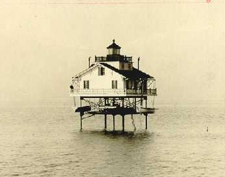
The Cobb Point Bar Light was a screw-pile lighthouse located in the Potomac River.

<span class="mw-page-title-main">Mallows Bay</span> Bay in Maryland, US with many shipwrecks

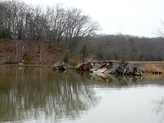
Mallows Bay is a small bay on the Maryland side of the Potomac River in Charles County, Maryland, United States. The bay is the location of what is regarded as the "largest shipwreck fleet in the Western Hemisphere" and is described as a "ship graveyard."

St. Inigoes, sometimes called St. Inigoes Shores, is a small, rural, unincorporated farming, fishing and crabbing community at the southern end of St. Mary's County in the U.S. state of Maryland that is undergoing a transition to small residential subdevelopment plots. Its western side is bordered by a number of coves and creeks that are connected to the St. Marys River, a brackish tidal tributary, near where it feeds into the mouth of the Potomac River and close to its entry point into the Chesapeake Bay.

<span class="mw-page-title-main">St. Mary's Peninsula</span>

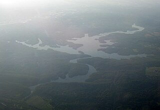
St. Mary's Peninsula is part of the Western Shore region of Maryland. From the Charles County line, just north of Charlotte Hall, Maryland, to the southern tip of St. Mary's County at Point Lookout State Park, St. Mary's Peninsula stretches about 39 miles (63 km). It is bordered on the southwest by the Potomac River, on the north and east by the Patuxent River and on the east by Chesapeake Bay. From the end of these two rivers, the peninsula has about 15 miles of shoreline along the Bay's western shore from Lexington Park, Maryland to Point Lookout. Its shoreline stretches for a total of 536 miles along the Patuxent River, Potomac River and the Chesapeake Bay.