Little Falls Township, Morrison County, Minnesota

Last updated
Little Falls Township, Minnesota
USA Minnesota location map.svg
Red pog.svg
Little Falls Township, Minnesota
Location within the state of Minnesota
Usa edcp location map.svg
Red pog.svg
Little Falls Township, Minnesota
Little Falls Township, Minnesota (the United States)
Coordinates: 45°57′12″N94°19′3″W / 45.95333°N 94.31750°W / 45.95333; -94.31750 Coordinates: 45°57′12″N94°19′3″W / 45.95333°N 94.31750°W / 45.95333; -94.31750
Country United States
State Minnesota
County Morrison
Area
  Total36.3 sq mi (94.1 km2)
  Land34.7 sq mi (89.8 km2)
  Water1.6 sq mi (4.3 km2)
Elevation
1,220 ft (372 m)
Population
 (2000)
  Total1,624
  Density46.8/sq mi (18.1/km2)
Time zone UTC-6 (Central (CST))
  Summer (DST) UTC-5 (CDT)
ZIP code
56345
Area code 320
FIPS code 27-37574 [1]
GNIS feature ID0664802 [2]

Little Falls Township is a township in Morrison County, Minnesota, United States. The population was 1,624 at the 2000 census.

Contents

Geography

According to the United States Census Bureau, the township has a total area of 36.3 square miles (94 km2), of which 34.7 square miles (90 km2) is land and 1.6 square miles (4.1 km2) (4.54%) is water.

It lies to the east of the Mississippi River.

Demographics

As of the census [1] of 2000, there were 1,624 people, 533 households, and 459 families residing in the township. The population density was 46.8 inhabitants per square mile (18.1/km2). There were 546 housing units at an average density of 15.7/sq mi (6.1/km2). The racial makeup of the township was 98.77% White, 0.12% African American, 0.18% Native American, 0.12% Asian, 0.18% from other races, and 0.62% from two or more races. Hispanic or Latino of any race were 0.62% of the population.

There were 533 households, out of which 42.0% had children under the age of 18 living with them, 78.2% were married couples living together, 5.3% had a female householder with no husband present, and 13.7% were non-families. 10.7% of all households were made up of individuals, and 3.2% had someone living alone who was 65 years of age or older. The average household size was 3.02 and the average family size was 3.23.

In the township the population was spread out, with 30.9% under the age of 18, 7.0% from 18 to 24, 29.6% from 25 to 44, 23.4% from 45 to 64, and 9.1% who were 65 years of age or older. The median age was 36 years. For every 100 females, there were 109.5 males. For every 100 females age 18 and over, there were 107.8 males.

The median income for a household in the township was $56,196, and the median income for a family was $60,250. Males had a median income of $35,000 versus $25,688 for females. The per capita income for the township was $22,083. About 2.1% of families and 2.5% of the population were below the poverty line, including 1.9% of those under age 18 and 4.7% of those age 65 or over.

Related Research Articles

<span class="mw-page-title-main">Hulbert Township, Michigan</span> Civil township in Michigan, United States

Hulbert Township is a civil township of Chippewa County in the Upper Peninsula of the U.S. state of Michigan. As of the 2010 census, the township population was 168.

<span class="mw-page-title-main">Clinton, Lenawee County, Michigan</span> Village in Michigan, United States

Clinton is a village in Lenawee County in the Irish Hills area of the U.S. state of Michigan. The population was 2,336 at the 2010 census. The village is located within Clinton Township.

<span class="mw-page-title-main">Clinton Township, Lenawee County, Michigan</span> Civil township in Michigan, United States

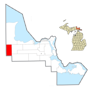
Clinton Township is a civil township of Lenawee County in the U.S. state of Michigan. The population was 3,624 at the 2000 census. The village of Clinton is located within the township.

Montmorency Township is a civil township of Montmorency County in the U.S. state of Michigan. The population was 1,202 at the 2000 census.

Fruitport Charter Township is a charter township of Muskegon County in the U.S. state of Michigan. The population was 12,533 at the 2000 census. The village of Fruitport is within the township.

<span class="mw-page-title-main">Edwards Township, Michigan</span> Civil township in Michigan, United States

Edwards Township is a civil township of Ogemaw County in the U.S. state of Michigan. The population was 1,413 at the 2010 census.

Fawn River Township is a civil township of St. Joseph County in the U.S. state of Michigan. The population was 1,648 at the 2000 census. The township is named for the Fawn River.

Bristol Township is a township in Fillmore County, Minnesota, United States. The population was 499 at the 2000 census.

Orion Township is a township in Olmsted County, Minnesota, United States. The population was 614 at the 2000 census.

Grove Township is a township in Stearns County, Minnesota, United States. The population was 493 at the 2010 census. The township includes the southern one-third of the City of Melrose and the City of Greenwald.

Lemond Township is a township in Steele County, Minnesota, United States. The population was 510 at the 2000 census.

Medford Township is a township in Steele County, Minnesota, United States. The population was 681 at the 2000 census.

Baytown Township is an urban township in Washington County, Minnesota, United States. The population was 1,533 at the 2000 census. The unincorporated community of Siegel is located within Baytown Township.

<span class="mw-page-title-main">Kimmel Township, Bedford County, Pennsylvania</span> Township in Pennsylvania, United States

Kimmel Township is a township in Bedford County, Pennsylvania, United States. The population was 1,522 at the 2020 census.

<span class="mw-page-title-main">Washington Township, Snyder County, Pennsylvania</span> Township in Pennsylvania, United States

Washington Township is a township in Snyder County, Pennsylvania, United States. The population was 1,756 at the 2020 census.

<span class="mw-page-title-main">Mineral Township, Venango County, Pennsylvania</span> Township in Pennsylvania, United States

Mineral Township is a township in Venango County, Pennsylvania, United States. The population was 494 at the 2020 census, a decrease from 538 in the 2010 census, which was, in turn, a gain over the 533 residents tabulated in 2000.

<span class="mw-page-title-main">Robinson Township, Washington County, Pennsylvania</span> Township in Pennsylvania, United States

Robinson Township is a township in Washington County, Pennsylvania, United States. The population was 1,705 at the 2020 census. It was formerly an area of interest concerning coal mining. A portion of the Montour Trail passes through Robinson Township.

<span class="mw-page-title-main">Loyalhanna Township, Westmoreland County, Pennsylvania</span> Township in Pennsylvania, United States

Loyalhanna Township is a township in Westmoreland County, Pennsylvania, United States. As of the 2020 census, the township had a total population of 2,093.

<span class="mw-page-title-main">Exeter Township, Wyoming County, Pennsylvania</span> Township in Pennsylvania, United States

Exeter Township is a township in Wyoming County, Pennsylvania, United States. The population was 624 at the 2020 census, of whom 382 people live in the village of West Falls, a census-designated place within the township.

<span class="mw-page-title-main">Tunkhannock Township, Wyoming County, Pennsylvania</span> Township in Pennsylvania, United States

Tunkhannock Township is a township in Wyoming County, Pennsylvania, United States. The population was 3,976 at the 2020 census.

References

  1. 1 2 "U.S. Census website". United States Census Bureau . Retrieved 2008-01-31.
  2. "US Board on Geographic Names". United States Geological Survey. 2007-10-25. Retrieved 2008-01-31.