
Morrison County is a county in the U.S. state of Minnesota. As of the 2020 census, the population was 34,010. Its county seat is Little Falls. Camp Ripley Military Reservation occupies a significant area in north-central Morrison County.
Alberta Township is a township in Benton County, Minnesota, United States. The population was 818 as of the 2010 census.
Graham Township is a township in Benton County, Minnesota, United States. The population was 582 as of the 2010 census.
Granite Ledge Township is a township in Benton County, Minnesota, United States. The population was 743 as of the 2010 census.

Buckman is a city in Morrison County, Minnesota, United States. The population was 307 at the 2020 Census.
Morrill Township is a township in Morrison County, Minnesota, United States. The population was 650 at the 2000 census.

Two Rivers Township is a township in Morrison County, Minnesota, United States. The population was 780 at the 2020 census.
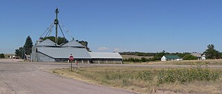
Cushing is an unincorporated community in Cushing Township, Morrison County, Minnesota, United States. The community is located along U.S. Highway 10 near Morrison County Road 5, Bear Road. Nearby places include Randall, Little Falls, and Motley.
Kelsey is an unincorporated community in Kelsey Township, Saint Louis County, Minnesota, United States.
Angora is an unincorporated community in northern Morrill County, Nebraska, United States. It lies along U.S. Route 385, north of the city of Bridgeport, the county seat of Morrill County. The community was established in 1900 by the Chicago, Burlington, and Quincy Railroad; it was named for the Turkish city of Ankara, which was then known as Angora. The Angora post office was established in 1901, and it remains open with the assigned ZIP code of 69331.
Little Rock is an unincorporated community in Buckman Township, Morrison County, Minnesota, United States. There are approximately 25 people living in Little Rock. The community is located along State Highway 25 near its junction with Morrison County Road 26, Nature Road. Nearby places include Buckman, Royalton, Rice, and Pierz. Bunker Hill Creek flows through the community.

North Prairie is an unincorporated community in Two Rivers Township, Morrison County, Minnesota, United States. The community is located along Morrison County Road 21 near Gable Road. Nearby places include Bowlus and Royalton. The Mississippi River is nearby.
Rice Lake is an unincorporated community in Stockholm Township, Wright County, Minnesota, United States. The community is located along Wright County Road 30 near Morrison Avenue SW.
Vawter is an unincorporated community in Morrison County, Minnesota, United States, near Little Falls and Royalton. The community is located along 103rd Street near Morrison County Road 35, Iris Road. Vawter is located within Bellevue Township and Little Falls Township. The Crane Meadows National Wildlife Refuge and the Rice–Skunk Lake Wildlife Management Area are both nearby.
Ramey is an unincorporated community in Morrill Township, Morrison County, Minnesota, United States. The community is located along 345th Avenue near its junction with Morrison County Road 26, Nature Road. Nearby places include Pierz, Hillman, and Foley.
Platte is an unincorporated community in Platte Township, Morrison County, Minnesota, United States, near Pierz. The community is located along 275th Avenue near its junction with Morrison County Road 48, 233rd Street. State Highway 25 is also in the immediate area. Wolf Creek and the Platte River meet at Platte.
Lincoln is an unincorporated community in Scandia Valley Township, Morrison County, Minnesota, United States. The community is located along U.S. Highway 10 near Holt Road. 320th Street and Azure Road are also in the immediate area. Nearby places include Motley, Cushing, and Little Falls.
Gregory is an unincorporated community in Little Falls Township, Morrison County, Minnesota, United States, near Little Falls. The community is located near the intersection of 123rd Street and Haven Road, Morrison County Road 76.
Freedhem is an unincorporated community in Belle Prairie Township, Morrison County, Minnesota, United States. The community is located near the junction of 203rd Street and Morrison County Road 45, Jewel Road. Nearby places include Little Falls, Pierz, and Camp Ripley.
Mae is an unincorporated community in Beulah Township, Cass County, Minnesota, United States, near Outing and Emily. It is located along Cass County Road 58, near Morrison Lake Road NE.


