Morrison County is a county in the U.S. state of Minnesota. As of the 2020 census, the population was 34,010. Its county seat is Little Falls. Camp Ripley Military Reservation occupies a significant area in north-central Morrison County.

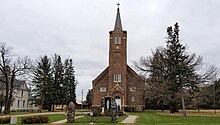
Little Falls is a city in Morrison County, Minnesota, United States, near the geographic center of the state. Established in 1848, Little Falls is one of the oldest European-American cities in Minnesota. It is the county seat of Morrison County. The population was 9,140 at the 2020 census, up from 8,343 in 2010. Little Falls was the boyhood home of noted aviator Charles Lindbergh. Just across from his former home is Charles A. Lindbergh State Park, named after Lindbergh's father, prominent Minnesota lawyer and U.S. Congressman Charles August Lindbergh.

Two Rivers Township is a township in Morrison County, Minnesota, United States. The population was 780 at the 2020 census.
Cushing is an unincorporated community in Cushing Township, Morrison County, Minnesota, United States. The community is located along U.S. Highway 10 near Morrison County Road 5, Bear Road. Nearby places include Randall, Little Falls, and Motley.
South Troy is an unincorporated community in Zumbro Township, Wabasha County, Minnesota, United States. It is located on U.S. Highway 63 about 13 miles north of Rochester. Nearby places include Hammond, Zumbro Falls, Mazeppa, Potsdam, and Oronoco. Wabasha County Roads 7 and 11 are nearby.
Bear River is an unincorporated community in Itasca and Saint Louis counties in the U.S. state of Minnesota.
French River is an unincorporated community in Duluth Township, Saint Louis County, Minnesota, United States; located on the North Shore of Lake Superior.

The Long Prairie River is a tributary of the Crow Wing River, 96 miles (154 km) long, in central Minnesota in the United States. Via the Crow Wing River, it is part of the watershed of the Mississippi River, draining an area of 892 square miles (2,310 km2) in a generally rural region.
Castle Rock is an unincorporated community in Castle Rock Township, Dakota County, Minnesota, United States.
Hope is an unincorporated community in Somerset Township, Steele County, Minnesota, United States. Hope has a post office with ZIP code 56046.
Little Rock is an unincorporated community in Buckman Township, Morrison County, Minnesota, United States. There are approximately 25 people living in Little Rock. The community is located along State Highway 25 near its junction with Morrison County Road 26, Nature Road. Nearby places include Buckman, Royalton, Rice, and Pierz. Bunker Hill Creek flows through the community.
Blackberry is an unincorporated community in Blackberry Township, Itasca County, Minnesota, United States.
Bixby is an unincorporated community in Aurora Township, Steele County, Minnesota, United States.

Jacobs Prairie is an unincorporated community in Wakefield Township, Stearns County, Minnesota, United States. The community is located along Stearns County Road 2 at Glacier Road near Cold Spring and Rockville.
Vawter is an unincorporated community in Morrison County, Minnesota, United States, near Little Falls and Royalton. The community is located along 103rd Street near Morrison County Road 35, Iris Road. Vawter is located within Bellevue Township and Little Falls Township. The Crane Meadows National Wildlife Refuge and the Rice–Skunk Lake Wildlife Management Area are both nearby.
Ramey is an unincorporated community in Morrill Township, Morrison County, Minnesota, United States. The community is located along 345th Avenue near its junction with Morrison County Road 26, Nature Road. Nearby places include Pierz, Hillman, and Foley.
Morrill is an unincorporated community in Morrill Township, Morrison County, Minnesota, United States. The community is located near the junction of 330th Avenue and Morrison County Road 26, Nature Road. Nearby places include Pierz, Hillman, Little Rock, Ramey, and Foley.
Lincoln is an unincorporated community in Scandia Valley Township, Morrison County, Minnesota, United States. The community is located along U.S. Highway 10 near Holt Road. 320th Street and Azure Road are also in the immediate area. Nearby places include Motley, Cushing, and Little Falls.
Freedhem is an unincorporated community in Belle Prairie Township, Morrison County, Minnesota, United States. The community is located near the junction of 203rd Street and Morrison County Road 45, Jewel Road. Nearby places include Little Falls, Pierz, and Camp Ripley.
Hassman is an unincorporated community in Morrison Township, Aitkin County, Minnesota, United States. The community is located near the junction of U.S. Highway 169 and State Highway 210, north of Aitkin. The Mississippi River and the Rice River both flow nearby.