Mary's Rock

Last updated
Mary's Rock

Marys rock.JPG

Mary's Rock in Autumn
Highest point
Elevation 3,514 ft (1,071 m)
Coordinates 38°39′01″N78°19′4″W / 38.65028°N 78.31778°W / 38.65028; -78.31778
Geography
Location Page / Rappahannock counties, Shenandoah National Park
Parent range Blue Ridge Mountains
Climbing
Easiest route Hike

Mary's Rock, also known as Marys Rock, is a 3,514-foot (1,071 m) tall mountain in Shenandoah National Park, Virginia, United States. The peak is just south of the Thornton Gap Entrance of the park, and north of the taller Pinnacle. Mary's Rock is the eighth highest peak in Shenandoah National Park.

Shenandoah National Park national park of the United States

Shenandoah National Park is a national park that encompasses part of the Blue Ridge Mountains in the U.S. state of Virginia. The park is long and narrow, with the broad Shenandoah River and Valley on the west side, and the rolling hills of the Virginia Piedmont on the east. Although the scenic Skyline Drive is likely the most prominent feature of the park, almost 40% of the land area 79,579 acres has been designated as wilderness and is protected as part of the National Wilderness Preservation System. The highest peak is Hawksbill Mountain at 4,051 feet (1,235 m).

Virginia State of the United States of America

Virginia, officially the Commonwealth of Virginia, is a state in the Southeastern and Mid-Atlantic regions of the United States located between the Atlantic Coast and the Appalachian Mountains. Virginia is nicknamed the "Old Dominion" due to its status as the first English colonial possession established in mainland North America and "Mother of Presidents" because eight U.S. presidents were born there, more than any other state. The geography and climate of the Commonwealth are shaped by the Blue Ridge Mountains and the Chesapeake Bay, which provide habitat for much of its flora and fauna. The capital of the Commonwealth is Richmond; Virginia Beach is the most populous city, and Fairfax County is the most populous political subdivision. The Commonwealth's estimated population as of 2018 is over 8.5 million.

Thornton Gap wind gap in Virginia, United States

Thornton Gap is a wind gap located in the Blue Ridge Mountains in Virginia separating the Shenandoah Valley from the Piedmont region of the state.

Contents

Hiking Mary's Rock

Two trails lead to the summit of Mary's Rock. One which starts from the Panorama Visitor Center and the other which starts from the Meadow Spring Parking Area. The trail from Panorama is somewhat longer and steeper, and is generally considered more difficult. It follows the white-blazed Appalachian Trail. The other trail is shorter and somewhat less difficult. The summit of the rock offers views of the northern section of Shenandoah National Park and Page Valley.

Appalachian Trail Hiking trail in the USA

The Appalachian National Scenic Trail, generally known as the Appalachian Trail or simply the A.T., is a marked hiking trail in the Eastern United States extending between Springer Mountain in Georgia and Mount Katahdin in Maine. The trail is about 2,200 miles (3,500 km) long, though the exact length changes over time as parts are modified or rerouted. The Appalachian Trail Conservancy describes the Appalachian Trail as the longest hiking-only trail in the world. More than 2 million people are said to take a hike on part of the trail at least once each year.

The Page Valley is a small valley geographically and culturally associated with the Shenandoah Valley. The valley is located between the Massanutten and Blue Ridge mountain ranges in western Virginia.

Legends of Mary's Rock

Mary's Rock Tunnel Mary's Rock Tunnel.jpg
Mary's Rock Tunnel

Mary's Rock has its fair share of legends of how the rock was named. One story claims that Francis Thornton wed Mary Savage and brought her up the mountain to show her the lands they would own together. In 2017 the song Mary's Rock, written by Will Hopkins, was recorded by Terry Baucom's Dukes of Drive. The popular bluegrass group had chart success with a version of this story, suggesting Francis Thornton pushed Mary, or Mary slipped and fell off the rock to her untimely death, allowing Thornton to inherit the land. Another legend claims that Thornton had a daughter named Mary, who climbed up the mountain when she was young and came back with a bear cub under her arm. Yet another states that it was named after the wife of William Randolph Barbee. [1]

William Randolph Barbee American sculptor

William Randolph Barbee was an American sculptor recognized for creating idealized, sentimental classical figures. Barbee's most notable works were the marble sculptures entitled Coquette and Fisher Girl.

Marys Rock Tunnel

Marys Rock Tunnel is a 610-foot (190 m) long tunnel blasted through the mountain that Skyline Drive passes through. Constructed in 1932, it is considered one of the engineering feats of Skyline Drive.

Marys Rock Tunnel building in Virginia, United States

The Marys Rock Tunnel is a vehicular tunnel in the Blue Ridge Mountains. Located at mile marker 32.2 on Skyline Drive, the scenic byway that traverses the length of Shenandoah National Park, it is the only vehicular tunnel in the park. Constructed in 1932 by workers employed with the Civilian Conservation Corps, the tunnel workers took three months to drill and blast through the east slopes of Mary's Rock. The two lane tunnel is 670 ft (200 m) long and only 12 ft 8 in (3.86 m) high, so recreational vehicles and taller trucks need to check their height restrictions before traveling through it.

Skyline Drive National Scenic Byway in Shenandoah National Park, Virginia, USA

Skyline Drive is a 105-mile (169 km) road that runs the entire length of the National Park Service's Shenandoah National Park in the Blue Ridge Mountains of Virginia, generally along the ridge of the mountains. The drive's northern terminus is at an intersection with U.S. Route 340 near Front Royal, and the southern terminus is at an interchange with US 250 near Interstate 64 (I-64) in Rockfish Gap, where the road continues south as the Blue Ridge Parkway. The road has intermediate interchanges with US 211 in Thornton Gap and US 33 in Swift Run Gap. Skyline Drive is part of Virginia State Route 48, which also includes the Virginia portion of the Blue Ridge Parkway, but this designation is not signed.

Related Research Articles

Rockingham County, Virginia County in the United States

Rockingham County is a county located in the U.S. state of Virginia. As of the 2010 census, the population was 76,314. Its county seat is the independent city of Harrisonburg.

Shenandoah Valley valley and cultural region of western Virginia and the Eastern Panhandle of West Virginia in the United States

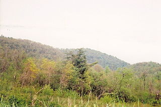
The Shenandoah Valley is a geographic valley and cultural region of western Virginia and the Eastern Panhandle of West Virginia in the United States. The valley is bounded to the east by the Blue Ridge Mountains, to the west by the eastern front of the Ridge-and-Valley Appalachians, to the north by the Potomac River and to the south by the James River. The cultural region covers a larger area that includes all of the valley plus the Virginia highlands to the west, and the Roanoke Valley to the south. It is physiographically located within the Ridge and Valley province and is a portion of the Great Appalachian Valley.

Blue Ridge Parkway scenic parkway in the United States

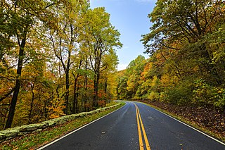
The Blue Ridge Parkway is a National Parkway and All-American Road in the United States, noted for its scenic beauty. The parkway, which is America's longest linear park, runs for 469 miles (755 km) through 29 Virginia and North Carolina counties, linking Shenandoah National Park to Great Smoky Mountains National Park. It runs mostly along the spine of the Blue Ridge, a major mountain chain that is part of the Appalachian Mountains. Its southern terminus is at U.S. 441 on the boundary between Great Smoky Mountains National Park and the Cherokee Indian Reservation in North Carolina, from which it travels north to Shenandoah National Park in Virginia. The roadway continues through Shenandoah as Skyline Drive, a similar scenic road which is managed by a different National Park Service unit. Both Skyline Drive and the Virginia portion of the Blue Ridge Parkway are part of Virginia State Route 48, though this designation is not signed.

Old Rag Mountain mountain in United States of America

Old Rag Mountain is a 3,284 feet (1,001 m) mountain near Sperryville in Madison County, Virginia. A part of the Blue Ridge Mountains, the peak is located within Shenandoah National Park and is the most popular hiking destination within the park.

Hawksbill Mountain mountain in United States of America

Hawksbill Mountain is a mountain with an elevation of 4,050 feet (1,230 m). Marking the border between Madison County and Page County in Virginia, the summit of Hawksbill Mountain is the highest point in Shenandoah National Park, as well as the highest point in both Madison and Page counties.

Rockfish Gap

Rockfish Gap is a wind gap located in the Blue Ridge Mountains between Charlottesville and Waynesboro, Virginia, United States, through Afton Mountain, which is frequently used to refer to the gap.

Swift Run Gap is a wind gap in the Blue Ridge Mountains located in the U.S. state of Virginia.

Big Meadows

Big Meadows is a recreational area of the Shenandoah National Park in Madison County and Page County, in the US state of Virginia. The meadow is located on the Skyline Drive at Milepost 51 and contains the park's Harry F. Byrd Visitor Center, a lodge, camp store, and camping area. Several hiking trails can be accessed from Big Meadows, including the Mill Prong Trail which leads to Rapidan Camp on the Rapidan River, the fishing retreat of President Herbert Hoover from 1929–1933, which is now restored to its 1930s configuration.

Sperryville, Virginia Census-designated place in Virginia, United States

Sperryville is a census-designated place (CDP) in Rappahannock County, Virginia, United States. The population as of the 2010 Census was 342.

Panorama Resort

Panorama Resort was one of the early resorts that lined what is now Skyline Drive in the Shenandoah National Park (SNP) in the United States, located at Thornton Gap. Like Skyland Resort and Little Switzerland, it was one of many private mountain resorts with nature themes that predated Skyline Drive and the Blue Ridge Parkway. Once one of Virginia’s best-known resorts, Panorama most recently operated as a restaurant destination in the Shenandoah National Park and was run by Aramark Parks and Resorts, the commercial vendor inside SNP that operated sister resorts Big Meadows and Skyland Resort. It was demolished in 2008.

Pignut Mountain mountain in United States of America

Pignut Mountain is a mountain in Rappahannock County, Virginia. It is part of the Blue Ridge Mountains. Its summit lies within Shenandoah National Park.

Knob Mountain Mountain in the Appalachian range

Knob Mountain is a mountain in Page County, Virginia. It is part of the Blue Ridge Mountains. Its summit lies within Shenandoah National Park at an elevation of 2,671 ft.

Neighbor Mountain part of Blue Ridge Mountains in Virginia

Neighbor Mountain is a mountain in Page and Rappahannock Counties, Virginia, near the city of Luray. It is part of the Blue Ridge Mountains. Its summit lies in Page County, within Shenandoah National Park.

High Knob is a peak of the Blue Ridge Mountains in Warren and Fauquier counties, Virginia.

Stony Man Mountain, also known as Stony Man, is a mountain in Shenandoah National Park, Virginia and is the most northerly 4,000 foot peak in the Blue Ridge Mountains. Its maximum elevation is 4,011 feet or 1,223 meters above sea level with a clean prominence of 651 feet. The mountain is co-located in Madison and Page counties and is easily accessed from Skyline Drive by hiking trails. Along with Hawksbill Mountain, it is only one of two peaks in the park higher than 4,000 feet. The shortest route to the summit is from the Skyland Resort and gains less than 400 vertical feet in about 1 kilometer. A longer, more challenging, route is from the Skyline Drive trail head at about milepost 39 of the Skyline Drive and gains almost 800 feet. The peak sits just southeast of the Appalachian Trail (AT) but the summit is accessible from the AT by previously mentioned spur trails. On the upper slopes of Stony Man one can see a few red spruce and balsam fir trees which typically grow in more northerly latitudes. The mountain is composed of ancient basalt which was metamorphosed into Greenstone through heat and pressure.

Hogback Mountain (Shenandoah National Park, Virginia)

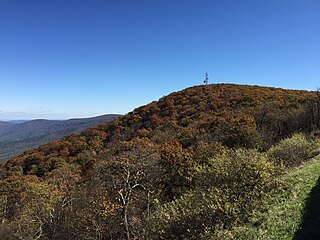
Hogback Mountain is the highest peak in the northern portion of Shenandoah National Park as well as the highest point in Warren County in northern Virginia, United States. A part of the Blue Ridge Mountains, it is located along the border of Warren and Rappahannock counties. It is easily accessible via Skyline Drive and the Appalachian Trail.

References

  1. Manning, Russ (31 March 2000). 75 Hikes in Virginia's Shenandoah National Park. The Mountaineers Books. pp. 76–. ISBN   978-0-89886-635-3 . Retrieved 23 August 2011.