Mile Oak

Last updated

Mile Oak
Eastward View along Chalky Road, Mile Oak (November 2015) (2).JPG
Eastward view along Chalky Road, Mile Oak, with the South Downs in the background
East Sussex UK location map.svg
Red pog.svg
Mile Oak
Location within East Sussex
Populationc. 10,300
OS grid reference TQ255065
Unitary authority
Ceremonial county
Region
Country England
Sovereign state United Kingdom
Post town Brighton
Postcode district BN41
Dialling code 01273
Police Sussex
Fire East Sussex
Ambulance South East Coast
UK Parliament
List of places
UK
England
East Sussex
50°51′18″N0°13′59″W / 50.855°N 0.233°W / 50.855; -0.233

Mile Oak is a locality forming the northern part of the former parish of Portslade in the northwest corner of the city of Brighton and Hove, England. Now mostly residential, but originally an area of good-quality agricultural land, it covers the area north of Portslade village as far as the urban boundary. [1]

Contents

Mile Oak is on the edge of the South Downs and as such has much farmland nearby; the Monarch's Way and Sussex Border Path long-distance footpaths skirt the edge of the built-up area. The first urban development occurred in the 1930s, and growth continued throughout the postwar era; houses were provided by the council, private builders and housing associations, many of them provided for people occupying substandard houses in the southern part of Portslade. [1]

The Portslade Aldridge Community Academy is located at Chalky Road and houses a public library, [2] although Brighton and Hove City Council announced in June 2023 that it would close the following month. Other local amenities include The Mile Oak Inn public house, the Anglican Church of the Good Shepherd and Mile Oak Farm.

History

The location of the oak tree to which the name "Mile Oak" refers is not known for certain, but researchers have suggested two sites. In 1935, a contributor to the Sussex County Magazine described "an old oak that stood on the roadway until about 30 years ago, when it gradually rotted away ... it was on the west side of the road, about a mile [north of] the old George Inn on [Portslade] High Street". Alternatively, it may have been at Mile Oak Farm further north. [3] Mile Oak, also spelt Mileoak in early documents, was first mentioned on a tithe map of 1840; and the Ordnance Survey map of 1873 identified Mileoak Cottages and Mileoak Barn on the road (now Mile Oak Road) leading north from Portslade village to the South Downs. Two families were recorded as living in Mile Oak in the 1881 census. [1] They were agricultural workers; the main farm in the area was Mile Oak Farm, which covered 294 acres (119 ha). [4]

Brighton Corporation bought Mile Oak Farm on 2 January 1890 with the intention of building a waterworks and pumping station there. This was completed in 1900 to the design of James Johnston, who also designed two adjacent cottages for waterworks employees [4] (these are now locally listed buildings). [5] The Corporation intended that the surrounding land should remain undeveloped to preserve the purity of the water. [1] Also in 1900, a rifle range was opened to replace an earlier facility in east Brighton. It was used by the 1st Volunteer Battalion of the Royal Sussex Regiment. It was in an isolated position north of Mile Oak Farm on the slopes of the South Downs; this seclusion made it an ideal location. The facility was set to be closed in September 1934, but it was used throughout World War II. No trace of it remains. [6]

Apart from a terrace of four houses on Mile Oak Road which date from the early 20th century and which are locally listed, [5] development of the area now known as Mile Oak began in the 1930s and was piecemeal. Portslade Council established a girls' school and built some council housing; private housing development also took place; and some people informally occupied land along Mile Oak Road and claimed squatters' rights. [1] A central focus to the Mile Oak area developed when Chalky Road was built up with private and housing association houses, shops and community buildings after World War II: until that time it was merely a chalk-covered cart track. East Sussex County Council built Portslade Senior Girls School, the predecessor of Portslade Community College, and a clinic and doctors' surgery in 1960. Mile Oak Gospel Hall followed in 1966. [7] Housebuilding then continued until the end of the 20th century, both on the land originally acquired by Brighton Corporation and on parcels of land in other ownership, and urban development is now continuous north of Portslade village to the South Downs. [1] Mile Oak Farm is still council-owned, and the remaining land and managed by tenant farmers. [8]

Notable buildings and areas

Church of the Good Shepherd, Mile Oak.jpg
Mile Oak Gospel Hall.jpg
The Church of the Good Shepherd (left) and Mile Oak Gospel Hall

Planning permission for an Anglican church for the Mile Oak area was granted in March 1936, and later that year a tin tabernacle was acquired with help from the Church of the Good Shepherd, Brighton and a private benefactor. The land and building cost £450, and it was dedicated on 8 November 1936. Work to replace this temporary facility began in June 1966, and on 28 October 1967 the new Church of the Good Shepherd was dedicated. It was designed by local architects Clayton, Black and Daviel (scheme architect M. G. Alford) in a Modernist style and cost £25,000; local churches including All Saints Church, Hove and St Nicolas Church, Portslade contributed towards this. It was consecrated in 1994 [9] and became a parish church in its own right in the same year, separating it from the parish of St Nicolas, Portslade. [10] It is a locally listed building. [11] Mile Oak Gospel Hall, a place of worship for the Church of God (Needed Truth Brethren), was built on Chalky Road in 1966. Hove Borough Council sold land to the community for £500, and construction cost £6,000; most of this was raised by the sale of the congregation's former chapel in Portslade. [7] It was registered for the solemnisation of marriages in August 1968. [12] The church closed in the early 2010s and is now occupied by the Brighton Wellness Centre. [13]

Mile Oak pub, Mile Oak Road, Mile Oak (November 2015) (2).JPG
Former Mill House pub, Mill Lane, Downs Park, Portslade (November 2015) (2).JPG
The Mile Oak Inn (left) and the former Mill House pub

The Mile Oak Inn on Mile Oak was designed in 1951 by local architects John Leopold Denman and Son for the Kemp Town Brewery of Brighton. [14] It is Neo-Georgian in style and opened in December 1954. The Campaign for Real Ale have listed it as a "Heritage Pub" with a historic interior of regional importance, noting the prevalence of original features and the retention of its traditional three-bar layout. [15] The Mill House Inn at the south end of Mile Oak, close to Portslade village, opened on Mill Lane in 1950 for the Tamplins Brewery of Brighton. [16] It closed in July 2013, [17] and a planning application for its demolition and replacement with houses was raised in July 2015. [18]

PORTSL~2.JPG
Mile Oak Community Centre, Chalky Road, Mile Oak (November 2015) (2).JPG
Portslade Aldridge Community Academy (left) and Mile Oak Community Centre

East Sussex County Council bought 12 acres (4.9 ha) of land at Mile Oak in 1937 and built Portslade Girls' School on the site. Pupils moved from a smaller school in Wellington Road in Portslade. The new building cost £19,800 and opened in 1940. It merged with Portslade Boys' School in Portslade High Street in 1972 to form Portslade Community College, which operated across both sites. [19] The Chalky Road building was extended soon after this, and a library which could be used by the public was also provided. Until it opened in May 1975, Mile Oak residents had to make do with "a few boxes of books in the community centre". The school is now called Portslade Aldridge Community Academy and is based solely at Mile Oak, the Portslade High Street site having been sold to another school. [20] The city council announced in June 2023 that the library would close on 21 July 2023. [21]

Portslade Industrial School, a "handsome structure of red brick", was built jointly by London County Council (who ran it from 1913) and Brighton Corporation in 1904 at a cost of £30,000. It was a reform school for boys, many of whom were sent there from outside Sussex. Later names were Mile Oak School, Mile Oak Approved School and finally (in 1971) Mile Oak Community Home. It closed in 1977, and after a brief period when the sixth form of Portslade Community College occupied it, the building and its attached farm were demolished and the site redeveloped for housing. [22]

Mile Oak Primary School opened in September 1965 on a site on Graham Avenue bought by East Sussex County Council 11 years earlier. It was designed by architect J. Catchpole and cost £48,000. By the start of the 21st century it had grown to be the largest primary school in the city of Brighton and Hove; an extension was built in 1999 at a cost of £475,000. [23] Hill Park School, for children with special educational needs, was created in September 2019 from the merger of Hillside and Downs Park Schools. [24] Downs Park School opened on its site on Foredown Road in October 1961, four years after it was established in the church hall of Bishop Hannington Memorial Church in West Blatchington. [25] Hillside School opened three years later on an adjacent site. [26]

Mile Oak Recreation Ground was laid out in the 1930s by Portslade Council. The land was part of a farm but had been used for dumping rubbish. It covers 3.4 hectares (8.4 acres) and is home to local football club Mile Oak F.C. A children's playground opened in 1992. [23]

Downs Park

Downs Park is an area of late 20th-century housing at the eastern edge of Mile Oak, between the estate and Hangleton. Although located in the borough of Hove, the land was owned by Brighton Borough Council. They built some council housing, and other houses were built by private developers and housing associations between the late 1970s and the 1990s. The area has no community facilities of its own, [25] although the large West Hove Sainsbury's supermarket is at the southern edge of the estate. The company bought the site in June 1989, and the store opened in October 1992 and was extended in July 1999. [27] Since 1986 Downs Park and the Sainsbury's supermarket have been served by the Brighton & Hove bus company's route 6 to Brighton station via Portslade station, Aldrington, central Hove and central Brighton. [28] A connecting road to the Mile Oak estate (Fox Way) was built the early 1990s but did not open until January 1996. [29] A large park was built on the north side of this road on a former chalk pit—a site with a "peculiar shape" and steep slope—funded by a housing trust and Brighton Borough Council; Hove Borough Council agreed to maintain the park. It opened in August 1994. [30]

Mile Oak and Portslade downland

Trig point at Mount Zion Trig point at Mount Zion - geograph.org.uk - 2587351.jpg
Trig point at Mount Zion

The A27 road separates the built-up area from a number of special downland areas to the north, which include Cockroost Hill to the northwest, Mount Zion to the northeast and Cockroost Bottom separating the two.

The name Cockroost may have come from the population of great bustard that used to inhabit the area and although bustards are no longer found here, there are some remarkable wildlife survivals, including the rare Pyralid Sitochroa palealis, orchids and butterflies. [31] There is also a lot of history to be found on these slopes including a large 4000-year-old Bronze Age settlement, which may have been a henge (as in Stonehenge), as well as evidence of Iron Age and Romano-British farming activity. [32]

Mount Zion's east slopes, north of New Barn Farm, are just as special. They have always been grazed and there are three valleys dotted with old anthills and orchids including the rare bee orchid. The most northerly valley has a little copse with hazel and dogwood. Goldfinches, linnets and migrant birds on passage enjoy its peace. [31]

There are two notable pathways on this downland. One of the two Mid Sussex tracks of the Sussex Border Path starts here, roughly separating East and West Sussex, and runs north into the parish of Fulking and then east through Pyecombe and as far as Ditchling. There is also the final stretch of the Monarch's Way which passes through Mile Oak and Portslade and follows the seafront west towards Shoreham. The Way is a 625-mile (1,006 km) long-distance footpath that runs from Worcester to Shoreham.

Transport

A route 1 bus to Mile Oak at Old Steine, Brighton BF12 KXR at Old Steine, Brighton, on Route 1 to Mile Oak (5 April 2015).JPG
A route 1 bus to Mile Oak at Old Steine, Brighton

A bypass for Brighton and Hove, rerouting the A27 trunk road away from inner suburban areas, was first discussed in the 1920s, but the borough and county councils only voted in favour of one in 1980–81. A route looping tightly around the northern boundary of the Mile Oak estate and the rest of the urban area was chosen. Hove Council insisted that the road must run entirely to the north of Mile Oak, rather than passing through it; this pushed the route further north and added engineering complexity, and the Department for Transport stated in 1982 that the budget would have to increase by £5.75 million to accommodate this change. Another disadvantage would be that it would sever Mile Oak Farm's buildings from its farmland. Construction started in 1989, but the section between Mile Oak and Southwick Hill Tunnel was the last to be built, between 1993 and 1995. The whole route opened in April 1996. [33] [34] There are no junctions leading into the estate; access can be obtained via the Hangleton Link Road (A293).

The Brighton & Hove bus company run regular services around the Mile Oak estate on routes 1 and 1A. Destinations include Portslade village, Portslade railway station, central Hove, central Brighton, Kemptown, the Royal Sussex County Hospital and Whitehawk. [28] Mile Oak's first bus service began in 1928 and ran from Portslade station to the waterworks. The "Mile Oak Shuttle", an express service to central Brighton using buses in a special livery, ran from 1982 to 1992. [8]

Sport and leisure

Mile Oak F.C. were founded in 1960 and play in Division One of the Southern Combination Football League, the tenth tier of the English football league system. They played in the Brighton, Hove & District Football League until 1987, when they moved up to the Sussex County League. [35] Home games are played at Mile Oak Recreation Ground, which has been equipped with floodlights since 1996. [36] Mile Oak Wanderers F.C. were formed in 2007 to provide youth football for the boys and girls within the local community. They originally played at Mile Oak Primary School, but since October 2010 all home matches have taken place at Southwick Hill Recreation Ground in Southwick, West Sussex. [37]

Portslade Sports Centre is part of the Portslade Aldridge Community Academy complex on Chalky Road. It has two sports halls, four squash courts, two exercise studios, a gymnasium and an all-weather 3G pitch. [38] The building, which opened at a cost of £115,200 in 1973, was designed by architect J. Catchpole. [39]

See also

Related Research Articles

<span class="mw-page-title-main">Hove</span> Seaside resort in East Sussex, England

Hove is a seaside resort in East Sussex, England. Alongside Brighton, it is one of the two main parts of the city of Brighton and Hove.

<span class="mw-page-title-main">Brighton and Hove</span> City and unitary authority in England

Brighton and Hove is a unitary authority with city status in East Sussex, England. There are multiple villages alongside the seaside resorts of Brighton and Hove in the district. It is administered by Brighton and Hove City Council, which is currently under Labour majority control.

<span class="mw-page-title-main">Portslade</span> Human settlement in England

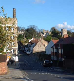
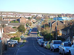
Portslade is a western suburb of the city of Brighton and Hove in the ceremonial county of East Sussex, England. Portslade Village, the original settlement a mile inland to the north, was built up in the 16th century. The arrival of the railway from Brighton in 1840 encouraged rapid development of the coastal area and in 1898 the southern part, formerly known as Copperas Gap, was granted urban district status and renamed Portslade-by-Sea, making it distinct from Portslade Village. After World War II the district of Mile Oak to the north was added. Today, Portslade is bisected from east to west by the old A27 road between Brighton and Worthing, each part having a distinct character.

<span class="mw-page-title-main">Hangleton</span> Suburb of Hove, Sussex, England

Hangleton is a suburb of Brighton and Hove, in the ceremonial county of East Sussex, England. The area was developed in the 1930s after it was incorporated into the Borough of Hove, but has ancient origins: its parish church was founded in the 11th century and retains 12th-century fabric; the medieval manor house is Hove's oldest secular building. The village became depopulated in the medieval era and the church fell into ruins, and the population in the isolated hilltop parish only reached 100 in the early 20th century; but rapid 20th-century development resulted in more than 6,000 people living in Hangleton in 1951 and over 9,000 in 1961. By 2013, the population exceeded 14,000.

<span class="mw-page-title-main">St Helen's Church, Hangleton</span> Church

St Helen's Church, an Anglican church in the Hangleton area of Hove, is the oldest surviving building in the English city of Brighton and Hove. It is the ancient parish church of Hangleton, an isolated South Downs village that was abandoned by the Middle Ages and was open farmland until the Interwar Period, when extensive residential development took place.

<span class="mw-page-title-main">St Peter's Church, West Blatchington</span> Church in England

St Peter's Church is an Anglican church in the West Blatchington area of Hove, part of the English city of Brighton and Hove. Although it has 11th- and 12th-century origins, the church was rebuilt from a ruined state in the late 19th century and extended substantially in the 1960s, and little trace remains of the ancient building. The church serves the parish of West Blatchington, a residential area in the north of Hove near the border with Brighton.

<span class="mw-page-title-main">St Nicolas Church, Portslade</span> Church in England

St Nicolas Church is an Anglican church in the Portslade area of the English city of Brighton and Hove. It has 12th-century origins, and serves the old village of Portslade, inland from the mostly 19th-century Portslade-by-Sea area.

<span class="mw-page-title-main">Holland Road Baptist Church</span> Church in Brighton and Hove , England

Holland Road Baptist Church is a Baptist church in Hove, part of the English city of Brighton and Hove. Built in 1887 to replace a temporary building on the same site, which had in turn superseded the congregation's previous meeting place in a nearby gymnasium, it expanded to take in nearby buildings and is a landmark on Holland Road, a main north–south route in Hove. It is one of ten extant Baptist church buildings in the city, and is the only one to have been listed by English Heritage in view of its architectural importance.

<span class="mw-page-title-main">Buildings and architecture of Brighton and Hove</span>

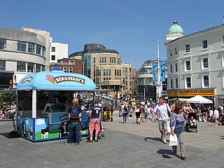
Brighton and Hove, a city on the English Channel coast in southeast England, has a large and diverse stock of buildings "unrivalled architecturally" among the country's seaside resorts. The urban area, designated a city in 2000, is made up of the formerly separate towns of Brighton and Hove, nearby villages such as Portslade, Patcham and Rottingdean, and 20th-century estates such as Moulsecoomb and Mile Oak. The conurbation was first united in 1997 as a unitary authority and has a population of about 253,000. About half of the 20,430-acre (8,270 ha) geographical area is classed as built up.

<span class="mw-page-title-main">Cemeteries and crematoria in Brighton and Hove</span> Review of the topic

The English coastal city of Brighton and Hove, made up of the formerly separate Boroughs of Brighton and Hove in East Sussex, has a wide range of cemeteries throughout its urban area. Many were established in the mid-19th century, a time in which the Victorian "cult of death" encouraged extravagant, expensive memorials set in carefully cultivated landscapes which were even recommended as tourist attractions. Some of the largest, such as the Extra Mural Cemetery and the Brighton and Preston Cemetery, were set in particularly impressive natural landscapes. Brighton and Hove City Council, the local authority responsible for public services in the city, manages seven cemeteries, one of which also has the city's main crematorium. An eighth cemetery and a second crematorium are owned by a private company. Many cemeteries are full and no longer accept new burials. The council maintains administrative offices and a mortuary at the Woodvale Cemetery, and employs a coroner and support staff.

<span class="mw-page-title-main">John Leopold Denman</span> British architect (1882–1975)

John Leopold DenmanFRIBA was an architect from the English seaside resort of Brighton, now part of the city of Brighton and Hove. He had a prolific career in the area during the 20th century, both on his own and as part of the Denman & Son firm in partnership with his son John Bluet Denman. Described as "the master of ... mid-century Neo-Georgian", Denman was responsible for a range of commercial, civic and religious buildings in Brighton, and pubs and hotels there and elsewhere on the south coast of England on behalf of Brighton's Kemp Town Brewery. He used other architectural styles as well, and was responsible for at least one mansion, several smaller houses, various buildings in cemeteries and crematoria, and alterations to many churches. His work on church restorations has been praised, and he has been called "the leading church architect of his time in Sussex"; he also wrote a book on the ecclesiastical architecture of the county.

<span class="mw-page-title-main">Hounsom Memorial United Reformed Church, Hove</span> Church in Brighton and Hove , United Kingdom

The Hounsom Memorial Church is a United Reformed place of worship in Hove in the English city of Brighton and Hove. One of six churches of that denomination in the city, it was built in 1938 for the Congregational Church, which became part of the United Reformed Church in 1972. Its name commemorates William Allin Hounsom, a local man and longstanding member of the Congregational church in central Hove, who had wide-ranging business interests and landholdings across Sussex. The red-brick building, one of many local works by Brighton-based architect John Leopold Denman, is embellished with carvings that have been called "quite startling for a Nonconformist church".

Clayton & Black were a firm of architects and surveyors from Brighton, part of the English city of Brighton and Hove. In a career spanning the Victorian, Edwardian and interwar eras, they were responsible for designing and constructing an eclectic range of buildings in the growing town of Brighton and its neighbour Hove. Their work encompassed new residential, commercial, industrial and civic buildings, shopping arcades, churches, schools, cinemas and pubs, and alterations to hotels and other buildings. Later reconstituted as Clayton, Black & Daviel, the company designed some churches in the postwar period.

<span class="mw-page-title-main">Palmeira Square</span> 19th century residences in Hove, England

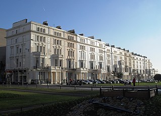
Palmeira Square is a mid-19th-century residential development in Hove, part of the English city and seaside resort of Brighton and Hove. At the southern end it adjoins Adelaide Crescent, another architectural set-piece which leads down to the seafront; large terraced houses occupy its west and east sides, separated by a public garden; and at the north end is one of Hove's main road junctions. This is also called Palmeira Square, and its north side is lined with late 19th-century terraced mansions. Commercial buildings and a church also stand on the main road, which is served by Brighton & Hove bus routes 1, 1A, N1, 2, 5, 5A, 5B, N5, 6, 25, 46, 49, 60, 71, 71A and 96.

<span class="mw-page-title-main">Prestonville, Brighton</span>

Prestonville is a largely residential area in the northwest of Brighton, part of the English city of Brighton and Hove. It covers a long, narrow and steeply sloping ridge of land between the Brighton Main Line and Dyke Road, two major transport corridors which run north-northwestwards from the centre of Brighton. Residential development started in the 1860s and spread northwards, further from central Brighton, over the next six decades. The area is characterised by middle-class and upper-middle-class housing in various styles, small-scale commercial development and long eastward views across the city. Two Anglican churches serve Prestonville—one at each end of the area—and there are several listed buildings.

<span class="mw-page-title-main">Libraries in Brighton and Hove</span>

The English coastal city of Brighton and Hove has a long and varied history of libraries going back over 250 years. Subscription libraries were among the earliest buildings in the resort of Brighton, which developed in the late 18th century; by the 1780s these facilities, which were more like social clubs than conventional book-borrowing venues, were at the heart of the town's social scene. The Brighton Literary Society, its successor the Brighton Royal Literary and Scientific Institution and its rival the Sussex Scientific Institution between them established a "very fine collection" of publications by the mid-19th century, and these books were donated to the town when a public library was founded in 1871. Neighbouring Hove, originally a separate village, established its own public library in 1890.

<span class="mw-page-title-main">Public services in Brighton and Hove</span>

Brighton and Hove, a city and unitary authority in the English county of East Sussex, has a wide range of public services funded by national government, East Sussex County Council, Brighton and Hove City Council and other public-sector bodies. Revenue to fund these services comes partly from Council Tax, which is paid annually by residents: this tax provides the city council with nearly 20% of its income and also helps to fund the local police force, Sussex Police, and the county's fire service, East Sussex Fire and Rescue Service. Some of Brighton and Hove's utilities and infrastructure are provided by outside parties, such as utility companies, rather than by the city council.

References

  1. 1 2 3 4 5 6 Middleton 2002 , Vol. 9, p. 43.
  2. "Mile Oak Library". Brighton & Hove City Council. Archived from the original on 9 August 2014.
  3. Middleton 2002 , Vol. 9, p. 42.
  4. 1 2 Middleton 2002 , Vol. 15, p. 40.
  5. 1 2 "Local List of Heritage Assets: M" (PDF). Brighton and Hove City Council. 2014. Archived (PDF) from the original on 5 March 2016. Retrieved 6 March 2020.
  6. Middleton 2002 , Vol. 9, pp. 50–51.
  7. 1 2 Middleton 2002 , Vol. 3, p. 22.
  8. 1 2 Middleton 2002 , Vol. 9, p. 47.
  9. Middleton 2002 , Vol. 6, p. 53.
  10. Middleton 2002 , Vol. 6, p. 54.
  11. "Local List of Heritage Assets: S" (PDF). Brighton and Hove City Council. 2014. Archived (PDF) from the original on 4 March 2016. Retrieved 6 March 2020.
  12. "No. 44669". The London Gazette . 5 September 1968. p. 9656.
  13. "Brighton Wellness Centre, Chalky Road, Mile Oak, Portslade, Brighton, East Sussex, BN41 2WF, United Kingdom". Shen Long Tai Chi Association UK. 2020. Archived from the original on 29 April 2018. Retrieved 4 March 2020.
  14. Middleton 2002 , Vol. 9, p. 48.
  15. "Mile Oak Inn". Campaign for Real Ale. 2020. Archived from the original on 4 March 2020. Retrieved 4 March 2020.
  16. Middleton 2002 , Vol. 9, p. 58.
  17. "Mill House". WhatPub website. Campaign for Real Ale. 6 January 2019. Archived from the original on 4 March 2020. Retrieved 4 March 2020.
  18. Wadsworth, Jo (14 July 2015). "Landmark Portslade pub set to be demolished to make way for homes". Brighton and Hove News. Archived from the original on 9 June 2017. Retrieved 4 March 2010.
  19. Middleton 2002 , Vol. 10, p. 102.
  20. Middleton 2002 , Vol. 10, pp. 87–89.
  21. le Duc, Frank (19 June 2023). "Mile Oak library to close next month". Brighton and Hove News. Archived from the original on 19 June 2023. Retrieved 19 June 2023.
  22. Middleton 2002 , Vol. 9, pp. 43–47.
  23. 1 2 Middleton 2002 , Vol. 9, p. 49.
  24. "Merger of Brighton and Hove special schools needs more money". 12 November 2018.
  25. 1 2 Middleton 2002 , Vol. 4, p. 32.
  26. Middleton 2002 , Vol. 7, p. 48.
  27. Middleton 2002 , Vol. 12, p. 19.
  28. 1 2 "Brighton Area Bus Routes" (PDF). Brighton & Hove Bus and Coach Company. September 2019. Archived (PDF) from the original on 3 May 2020. Retrieved 3 May 2020.
  29. Middleton 2002 , Vol. 5, p. 58.
  30. Middleton 2002 , Vol. 5, p. 57.
  31. 1 2 Bangs, Dave (2008). A freedom to roam Guide to the Brighton Downs : from Shoreham to Newhaven and Beeding to Lewes. Brighton: David Bangs. ISBN   978-0-9548638-1-4. OCLC   701098669.
  32. Wilkinson, K.N., 2003. Colluvial deposits in dry valleys of southern England as proxy indicators of paleoenvironmental and land‐use change. Geoarchaeology: An International Journal, 18(7), pp.725-755.
  33. Middleton 2002 , Vol. 2, pp. 119–120.
  34. Carder 1990 , §. 27.
  35. "Mile Oak". Football Club History Database. 2000–2019. Archived from the original on 4 September 2019. Retrieved 8 March 2020.
  36. Middleton 2002 , Vol. 9, p. 50.
  37. "History of Mile Oak Wanderers F.C." Mile Oak Wanderers F.C./Pitch Hero Ltd. November 2011. Archived from the original on 9 March 2020. Retrieved 9 March 2020.
  38. "Portslade Sports Centre". Freedom Leisure. 2020. Archived from the original on 21 October 2019. Retrieved 8 March 2020.
  39. Middleton 2002 , Vol. 10, p. 89.

Bibliography