National Register of Historic Places listings in Franklin County, Virginia

Last updated

Location of Franklin County in Virginia Map of Virginia highlighting Franklin County.svg
Location of Franklin County in Virginia

This is a list of the National Register of Historic Places listings in Franklin County, Virginia.

Contents

This is intended to be a complete list of the properties and districts on the National Register of Historic Places in Franklin County, Virginia, United States. The locations of National Register properties and districts for which the latitude and longitude coordinates are included below, may be seen in an online map. [1]

There are 26 properties and districts listed on the National Register in the county.


    This National Park Service list is complete through NPS recent listings posted March 3, 2023. [2]

Map all coordinates using: OpenStreetMap  
Download coordinates as: KML

Current listings

[3] Name on the Register [4] ImageDate listed [5] Location City or townDescription
1 Bleak Hill
Bleak Hill Bleak Hill Lane.jpg
Bleak Hill
November 21, 2002
(#02001374)
215 Bleak Hill Ln. [6]
36°58′13″N80°02′08″W / 36.970278°N 80.035556°W / 36.970278; -80.035556 (Bleak Hill)
Callaway
2 Boones Mill Depot
Boones Mill Depot Boones Mill Depot.jpg
Boones Mill Depot
June 5, 2017
(#100001042)
Digby Greene Rd. and Depot Dr.
37°06′57″N79°56′51″W / 37.115833°N 79.947500°W / 37.115833; -79.947500 (Boones Mill Depot)
Boones Mill
3 Boones Mill Historic District
Boones Mill Historic District Farmers and Merchants Bank, Boones Mill.jpg
Boones Mill Historic District
August 25, 2014
(#14000526)
U.S. Route 220, Maggodee Ln., Bethlehem, Dogwood Hill, and Boones Mill Rds., and Boon, Easy, and Church Hill Sts.
37°06′58″N79°57′18″W / 37.116111°N 79.955000°W / 37.116111; -79.955000 (Boones Mill Historic District)
Boones Mill
4 Booth-Lovelace House
Booth-Lovelace House Booth-Lovelace fields.jpg
Booth-Lovelace House
September 14, 2002
(#02000996)
130 Lovelace Ln.
37°10′18″N79°52′00″W / 37.171667°N 79.866667°W / 37.171667; -79.866667 (Booth-Lovelace House)
Hardy
5 Bowman Farm
Bowman Farm Bowman Farmhouse from the south.jpg
Bowman Farm
April 13, 2000
(#00000314)
1605 Cahas Mountain Rd.
37°06′01″N80°01′04″W / 37.100278°N 80.017778°W / 37.100278; -80.017778 (Bowman Farm)
Boones Mill
6 Brooks-Brown House
Brooks-Brown House Brooks-Brown House.jpg
Brooks-Brown House
November 2, 1989
(#89001930)
Truevine Rd. north of Snow Creek Rd.
36°55′17″N79°42′27″W / 36.921389°N 79.707500°W / 36.921389; -79.707500 (Brooks-Brown House)
Dickinson
7 Burwell-Holland House
Burwell-Holland House Burwell-Holland House from the road.jpg
Burwell-Holland House
June 6, 2002
(#02000624)
600 Jacks Mountain Rd.
36°58′38″N79°44′26″W / 36.977361°N 79.740556°W / 36.977361; -79.740556 (Burwell-Holland House)
Glade Hill
8 Cahas Mountain Rural Historic District
Cahas Mountain Rural Historic District Apple at Naff, outside Boones Mill.jpg
Cahas Mountain Rural Historic District
June 7, 1996
(#96000593)
From the peak of Cahas Mountain to near the Roanoke County line, near the junction of U.S. Route 220 and Naff Rd.
37°08′03″N79°59′09″W / 37.134167°N 79.985833°W / 37.134167; -79.985833 (Cahas Mountain Rural Historic District)
Boones Mill
9 John Craghead House
John Craghead House Faodail, The John Craghead House.jpg
John Craghead House
March 24, 2022
(#100007571)
1609 Windlass Rd.
37°06′10″N79°38′56″W / 37.1027°N 79.6488°W / 37.1027; -79.6488 (John Craghead House)
Moneta vicinity
10 Gwin Dudley Home Site
Gwin Dudley Home Site Gwin Dudley homeplace.jpg
Gwin Dudley Home Site
January 30, 2008
(#07000827)
Twin Chimneys Dr.
37°02′52″N79°41′20″W / 37.047778°N 79.688750°W / 37.047778; -79.688750 (Gwin Dudley Home Site)
Wirtz
11 Jubal A. Early House
Jubal A. Early House Jubal Early House.jpg
Jubal A. Early House
December 11, 1997
(#97001507)
Northwest of the junction of State Route 116 and Boones Mill Rd.
37°09′47″N79°52′50″W / 37.163056°N 79.880556°W / 37.163056; -79.880556 (Jubal A. Early House)
Boones Mill
12 Evergreen-Callaway-Deyerle House
Evergreen-Callaway-Deyerle House Evergreen-Callaway-Deyerle House in Franklin County Va.jpg
Evergreen-Callaway-Deyerle House
December 9, 1999
(#99001504)
536 Coles Creek Rd.
37°00′57″N79°58′25″W / 37.015833°N 79.973611°W / 37.015833; -79.973611 (Evergreen-Callaway-Deyerle House)
Rocky Mount
13 The Farm
The Farm The Farm, ironmaster's house in Rocky Mount.jpg
The Farm
November 2, 1989
(#89001910)
Lawndale Dr.
36°59′21″N79°53′35″W / 36.989167°N 79.892917°W / 36.989167; -79.892917 (The Farm)
Rocky Mount
14 Ferrum College Historic District
Ferrum College Historic District Britt Hall, Ferrum College.jpg
Ferrum College Historic District
October 29, 2013
(#13000889)
215 Ferrum Mountain Rd.
36°55′35″N80°01′14″W / 36.926389°N 80.020556°W / 36.926389; -80.020556 (Ferrum College Historic District)
Ferrum
15 Finney-Lee House
Finney-Lee House Finney-Lee House.jpg
Finney-Lee House
May 23, 1997
(#97000484)
0.75 miles (1.21 km) north of the junction of Sutton Hollow and Snow Creek Rds.
36°50′09″N79°47′45″W / 36.835972°N 79.795833°W / 36.835972; -79.795833 (Finney-Lee House)
Snow Creek
16 Greer House
Greer House Greer House in Rocky Mount.jpg
Greer House
December 28, 1990
(#90002011)
206 E. Court St.
36°59′41″N79°53′10″W / 36.994861°N 79.886111°W / 36.994861; -79.886111 (Greer House)
Rocky Mount
17 Holland-Duncan House
Holland-Duncan House Holland-Duncan House front.jpg
Holland-Duncan House
January 28, 2000
(#00000026)
13508 State Route 122
37°07′14″N79°42′42″W / 37.120556°N 79.711667°W / 37.120556; -79.711667 (Holland-Duncan House)
Moneta
18 Hook-Powell-Moorman Farm
Hook-Powell-Moorman Farm Hook-Powell-Moorman Farmhouse.jpg
Hook-Powell-Moorman Farm
July 21, 1995
(#95000893)
Junction of State Route 122 and Dovetail Rd.
37°08′27″N79°40′47″W / 37.140833°N 79.679722°W / 37.140833; -79.679722 (Hook-Powell-Moorman Farm)
Hale's Ford
19 Otter Creek Archaeological Site (44FR31)
Otter Creek Archaeological Site (44FR31) Otter Creek Site from Buffalo Ridge Rd.jpg
Otter Creek Archaeological Site (44FR31)
May 9, 1985
(#85000986)
Off Newcomb Rd. at the headwaters of Otter Creek [7]
36°56′29″N80°07′20″W / 36.941389°N 80.122222°W / 36.941389; -80.122222 (Otter Creek Archaeological Site (44FR31))
Ferrum
20 Piedmont Mill Historic District
Piedmont Mill Historic District Piedmont Mill and surroundings.jpg
Piedmont Mill Historic District
February 27, 2009
(#09000063)
1709 Alean Rd.
37°05′36″N79°51′17″W / 37.093333°N 79.854722°W / 37.093333; -79.854722 (Piedmont Mill Historic District)
Boones Mill
21 Rocky Mount Historic District
Rocky Mount Historic District Franklin County Courthouse Rocky Mount Virginia.JPG
Rocky Mount Historic District
June 3, 1999
(#99000683)
Roughly bounded by Franklin and Maynor Sts., Floyd Ave., E. Court St., and Maple Ave.; also Orchard Ave. between E. Court and Patterson Sts.
36°59′44″N79°53′21″W / 36.995556°N 79.889167°W / 36.995556; -79.889167 (Rocky Mount Historic District)
Rocky Mount Orchard Ave. represents a boundary increase of May 15, 2008
22 Snow Creek Anglican Church
Snow Creek Anglican Church Snow Creek Anglican Church.jpg
Snow Creek Anglican Church
February 21, 2017
(#100000676)
436 Old Chapel Rd.
36°55′06″N79°39′43″W / 36.918333°N 79.661944°W / 36.918333; -79.661944 (Snow Creek Anglican Church)
Penhook
23 Booker T. Washington National Monument
Booker T. Washington National Monument Burroughs Family Cemetery on former Burroughs Plantation now Booker T. Washington National Monument.jpg
Booker T. Washington National Monument
October 15, 1966
(#66000834)
15 miles (24 km) east of Rocky Mount on State Route 122
37°07′14″N79°43′54″W / 37.120417°N 79.731667°W / 37.120417; -79.731667 (Booker T. Washington National Monument)
Rocky Mount
24 Washington Iron Furnace
Washington Iron Furnace Exterior view Washington Iron Works Franklin County Virginia.JPG
Washington Iron Furnace
March 20, 1973
(#73002014)
108 Old Furnace Rd.
36°59′13″N79°53′31″W / 36.986944°N 79.891944°W / 36.986944; -79.891944 (Washington Iron Furnace)
Rocky Mount
25 Waverly
Waverly Waverly from SR 122.jpg
Waverly
November 7, 1996
(#96001329)
Northern side of State Route 122 2 miles (3.2 km) northeast of its junction with State Route 116
37°07′11″N79°47′28″W / 37.119722°N 79.791111°W / 37.119722; -79.791111 (Waverly)
Burnt Chimney
26 Woods-Meade House
Woods-Meade House Woods-Meade House in Rocky Mount.jpg
Woods-Meade House
July 8, 1982
(#82004557)
118 Maple St.
36°59′48″N79°53′16″W / 36.996667°N 79.887778°W / 36.996667; -79.887778 (Woods-Meade House)
Rocky Mount

See also

Related Research Articles

<span class="mw-page-title-main">National Register of Historic Places listings in Alleghany County, Virginia</span>

This is a list of the National Register of Historic Places listings in Alleghany County, Virginia.

<span class="mw-page-title-main">National Register of Historic Places listings in Amelia County, Virginia</span>

This is a list of the National Register of Historic Places listings in Amelia County, Virginia.

<span class="mw-page-title-main">National Register of Historic Places listings in Bedford County, Virginia</span>

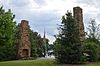
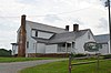
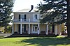
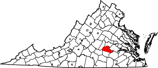
This is a list of the National Register of Historic Places listings in Bedford County, Virginia.

<span class="mw-page-title-main">National Register of Historic Places listings in Washington County, Virginia</span>

This is a list of the National Register of Historic Places listings in Washington County, Virginia.

<span class="mw-page-title-main">National Register of Historic Places listings in Clarke County, Virginia</span>

This is a list of the National Register of Historic Places listings in Clarke County, Virginia.

<span class="mw-page-title-main">National Register of Historic Places listings in Franklin County, Florida</span>

This is a list of the National Register of Historic Places listings in Franklin County, Florida.

<span class="mw-page-title-main">National Register of Historic Places listings in Brooke County, West Virginia</span>

This is a list of the National Register of Historic Places listings in Brooke County, West Virginia.

<span class="mw-page-title-main">National Register of Historic Places listings in Isle of Wight County, Virginia</span>

This is a list of the National Register of Historic Places listings in Isle of Wight County, Virginia.

<span class="mw-page-title-main">National Register of Historic Places listings in Goochland County, Virginia</span>

This is a list of the National Register of Historic Places listings in Goochland County, Virginia.

<span class="mw-page-title-main">National Register of Historic Places listings in Greene County, Virginia</span>

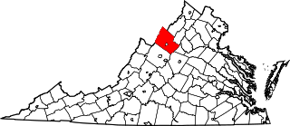
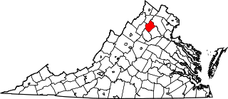
This is a list of the National Register of Historic Places listings in Greene County, Virginia.

<span class="mw-page-title-main">National Register of Historic Places listings in Rockingham County, Virginia</span>

This is a list of the National Register of Historic Places listings in Rockingham County, Virginia.

<span class="mw-page-title-main">National Register of Historic Places listings in New Kent County, Virginia</span>

This is a list of the National Register of Historic Places listings in New Kent County, Virginia.

<span class="mw-page-title-main">National Register of Historic Places listings in Northampton County, Virginia</span>

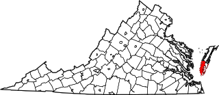
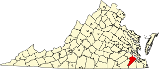
This is a list of the National Register of Historic Places listings in Northampton County, Virginia.

<span class="mw-page-title-main">National Register of Historic Places listings in Orange County, Virginia</span>

This is a list of the National Register of Historic Places listings in Orange County, Virginia.

<span class="mw-page-title-main">National Register of Historic Places listings in Rappahannock County, Virginia</span>

This is a list of the National Register of Historic Places listings in Rappahannock County, Virginia.

<span class="mw-page-title-main">National Register of Historic Places listings in Shenandoah County, Virginia</span>

This is a list of the National Register of Historic Places listings in Shenandoah County, Virginia.

<span class="mw-page-title-main">National Register of Historic Places listings in Patrick County, Virginia</span>

This is a list of the National Register of Historic Places listings in Patrick County, Virginia.

<span class="mw-page-title-main">National Register of Historic Places listings in Lewis County, West Virginia</span>

This is a list of the National Register of Historic Places listings in Lewis County, West Virginia.

<span class="mw-page-title-main">National Register of Historic Places listings in Franklin, Virginia</span>

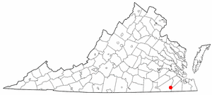
This is a list of the National Register of Historic Places listings in Franklin, Virginia.

<span class="mw-page-title-main">National Register of Historic Places listings in Grayson County, Virginia</span>

This is a list of the National Register of Historic Places listings in Grayson County, Virginia.

References

  1. The latitude and longitude information provided in this table was derived originally from the National Register Information System, which has been found to be fairly accurate for about 99% of listings. Some locations in this table may have been corrected to current GPS standards.
  2. National Park Service, United States Department of the Interior, "National Register of Historic Places: Weekly List Actions", retrieved March 3, 2023.
  3. Numbers represent an alphabetical ordering by significant words. Various colorings, defined here, differentiate National Historic Landmarks and historic districts from other NRHP buildings, structures, sites or objects.
  4. "National Register Information System". National Register of Historic Places . National Park Service. April 24, 2008.
  5. The eight-digit number below each date is the number assigned to each location in the National Register Information System database, which can be viewed by clicking the number.
  6. Beckett, Ann Stuart. National Register of Historic Places Inventory/Nomination: Bleak Hill. National Park Service, 2002-07-08, 23.
  7. Egloff, K.T., et al. "The Otter Creek Site (44FR31): a late woodland hamlet along the Blue Ridge escarpment." Quarterly Bulletin of the Archeological Society of Virginia 42.1 (1987): 1-15: 5