National Register of Historic Places listings in Mathews County, Virginia

Last updated

Location of Mathews County in Virginia Map of Virginia highlighting Mathews County.svg
Location of Mathews County in Virginia

This is a list of the National Register of Historic Places listings in Mathews County, Virginia.

Contents

This is intended to be a complete list of the properties and districts on the National Register of Historic Places in Mathews County, Virginia, United States. The locations of National Register properties and districts for which the latitude and longitude coordinates are included below, may be seen in an online map. [1]

There are 16 properties and districts listed on the National Register in the county.


    This National Park Service list is complete through NPS recent listings posted May 10, 2024. [2]

Current listings

[3] Name on the Register [4] ImageDate listed [5] Location City or townDescription
1 Billups House
Billups House Billups House.jpg
Billups House
March 26, 1980
(#80004199)
East of Moon
37°26′31″N76°17′11″W / 37.441944°N 76.286389°W / 37.441944; -76.286389 (Billups House)
Moon
2 Fort Cricket Hill
Fort Cricket Hill Fort Cricket Hill.jpg
Fort Cricket Hill
June 15, 1970
(#70000811)
East of the Gwynn's Island bridge [6]
37°29′15″N76°18′22″W / 37.487500°N 76.306111°W / 37.487500; -76.306111 (Fort Cricket Hill)
Hudgins Revolutionary War fortifications
3 Gwynn's Island Historic District May 6, 2024
(#100010202)
Generally including Route 223 (Cricket Hill Rd.), Route 633 (Old Ferry Road, N. Bay Haven Road). Route 740 (Hill Plantation Road)
37°30′20″N76°17′32″W / 37.5055°N 76.2921°W / 37.5055; -76.2921 (Gwynn's Island Historic District)
Gwynn
4 Hesse
Hesse Hesse estate entrance.jpg
Hesse
February 12, 1974
(#74002137)
East of Cobbs Creek off Proctor Ln.
37°30′49″N76°21′37″W / 37.513611°N 76.360278°W / 37.513611; -76.360278 (Hesse)
Blakes
5 The Lane Hotel
The Lane Hotel Lane Hotel in Mathews.jpg
The Lane Hotel
March 1, 2011
(#11000065)
68 Church St.
37°26′03″N76°19′19″W / 37.434167°N 76.322083°W / 37.434167; -76.322083 (The Lane Hotel)
Mathews
6 Mathews County Courthouse Square
Mathews County Courthouse Square MATHEWS COUNTY COURTHOUSE SQUARE.jpg
Mathews County Courthouse Square
August 18, 1977
(#77001491)
Church St.
37°26′00″N76°19′20″W / 37.433333°N 76.322222°W / 37.433333; -76.322222 (Mathews County Courthouse Square)
Mathews
7 Mathews Downtown Historic District
Mathews Downtown Historic District Main south of Court, Mathews CH.jpg
Mathews Downtown Historic District
September 18, 2017
(#100001642)
Mathews County Courthouse Square and vicinity
37°26′01″N76°19′16″W / 37.433611°N 76.321111°W / 37.433611; -76.321111 (Mathews Downtown Historic District)
Mathews
8 Methodist Tabernacle
Methodist Tabernacle METHODIST TABERNACLE.jpg
Methodist Tabernacle
May 21, 1975
(#75002024)
Southeast of Mathews on Tabernacle Rd. at its junction with Salem Church Rd.
37°25′19″N76°17′47″W / 37.421944°N 76.296389°W / 37.421944; -76.296389 (Methodist Tabernacle)
Mathews
9 New Point Comfort Lighthouse
New Point Comfort Lighthouse NEW POINT COMFORT LIGHTHOUSE 100 500.jpg
New Point Comfort Lighthouse
March 1, 1973
(#73002037)
Junction of Chesapeake Bay and Mobjack Bay
37°18′04″N76°16′40″W / 37.301111°N 76.277778°W / 37.301111; -76.277778 (New Point Comfort Lighthouse)
New Point
10 Old Thomas James Store
Old Thomas James Store James Store Interior.jpg
Old Thomas James Store
March 28, 2008
(#08000244)
Main and Maple Sts.
37°26′01″N76°19′14″W / 37.433611°N 76.320417°W / 37.433611; -76.320417 (Old Thomas James Store)
Mathews Court House
11 Poplar Grove Mill and House
Poplar Grove Mill and House Poplar Grove House.jpg
Poplar Grove Mill and House
November 12, 1969
(#69000259)
Southwest of the junction of State Route 14 and Poplar Grove Ln.
37°23′54″N76°20′07″W / 37.398333°N 76.335278°W / 37.398333; -76.335278 (Poplar Grove Mill and House)
Williams
12 Riverlawn
Riverlawn Riverlawn near Williams Wharf.jpg
Riverlawn
August 22, 2012
(#12000543)
134 Williamsdale Lane
37°24′36″N76°20′30″W / 37.410000°N 76.341667°W / 37.410000; -76.341667 (Riverlawn)
Mathews
13 Sibley's and James Store Historic District
Sibley's and James Store Historic District Sibley's and James Store HD.jpg
Sibley's and James Store Historic District
March 24, 2010
(#10000093)
239 Main St. (Main and Maple Sts.)
37°26′01″N76°19′15″W / 37.433611°N 76.320833°W / 37.433611; -76.320833 (Sibley's and James Store Historic District)
Mathews
14 Springdale
Springdale Springdale1735.JPG
Springdale
May 23, 2013
(#13000339)
1108 State Route 14
37°25′20″N76°19′41″W / 37.422222°N 76.328056°W / 37.422222; -76.328056 (Springdale)
Mathews
15 B. Williams & Co. Store
B. Williams & Co. Store Williams and Company Store, Mathews.jpg
B. Williams & Co. Store
June 3, 2009
(#09000394)
1030 Williams Wharf Rd.
37°24′15″N76°20′43″W / 37.404167°N 76.345278°W / 37.404167; -76.345278 (B. Williams & Co. Store)
Mathews
16 Wolf Trap Light Station
Wolf Trap Light Station USCGwolftraplight1960.jpg
Wolf Trap Light Station
December 2, 2002
(#02001434)
Southeast of New Point Comfort
37°13′49″N76°11′24″W / 37.230278°N 76.190000°W / 37.230278; -76.190000 (Wolf Trap Light Station)
Poquoson East

Former listings

[3] Name on the RegisterImageDate listedDate removedLocation City or townDescription
1 Donk's Theatre
Donk's Theatre Donk's.jpg
Donk's Theatre
January 28, 2011
(#10001185)
February 7, 2017259 Buckley Hall Rd.
37°28′18″N76°19′35″W / 37.471528°N 76.326389°W / 37.471528; -76.326389 (Donk's Theatre)
Hudgins On January 22, 2016, the roof of Donk's collapsed due to heavy snowfall from a winter storm, as did several of the outside walls. Little survived, and what remained required demolition. [7] [8]

See also

Related Research Articles

<span class="mw-page-title-main">National Register of Historic Places listings in Albemarle County, Virginia</span>

This is a list of the National Register of Historic Places listings in Albemarle County, Virginia.

<span class="mw-page-title-main">National Register of Historic Places listings in Alexandria, Virginia</span>

This is a list of the National Register of Historic Places listings in Alexandria, Virginia.

<span class="mw-page-title-main">National Register of Historic Places listings in Amelia County, Virginia</span>

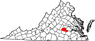
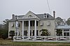
This is a list of the National Register of Historic Places listings in Amelia County, Virginia.

<span class="mw-page-title-main">National Register of Historic Places listings in Rockbridge County, Virginia</span>

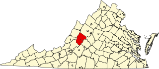
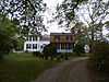
This is a list of the National Register of Historic Places listings in Rockbridge County, Virginia.

<span class="mw-page-title-main">National Register of Historic Places listings in Caroline County, Virginia</span>

This is a list of the National Register of Historic Places listings in Caroline County, Virginia.

<span class="mw-page-title-main">National Register of Historic Places listings in Richmond, Virginia</span>

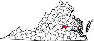
This is a list of the National Register of Historic Places listings in Richmond, Virginia.

<span class="mw-page-title-main">National Register of Historic Places listings in Hanover County, Virginia</span>

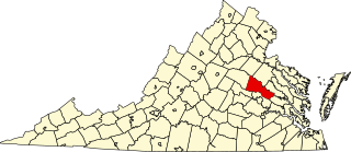
This is a list of the National Register of Historic Places listings in Hanover County, Virginia.

<span class="mw-page-title-main">National Register of Historic Places listings in Clarke County, Virginia</span>

This is a list of the National Register of Historic Places listings in Clarke County, Virginia.

<span class="mw-page-title-main">National Register of Historic Places listings in Fluvanna County, Virginia</span>

This is a list of the National Register of Historic Places listings in Fluvanna County, Virginia.

<span class="mw-page-title-main">National Register of Historic Places listings in Spotsylvania County, Virginia</span>

This is a list of the National Register of Historic Places listings in Spotsylvania County, Virginia.

<span class="mw-page-title-main">National Register of Historic Places listings in Gloucester County, Virginia</span>

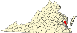
This is a list of the National Register of Historic Places listings in Gloucester County, Virginia.

<span class="mw-page-title-main">National Register of Historic Places listings in Goochland County, Virginia</span>

This is a list of the National Register of Historic Places listings in Goochland County, Virginia.

<span class="mw-page-title-main">National Register of Historic Places listings in Greene County, Virginia</span>

This is a list of the National Register of Historic Places listings in Greene County, Virginia.

<span class="mw-page-title-main">National Register of Historic Places listings in Orange County, Virginia</span>

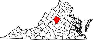
This is a list of the National Register of Historic Places listings in Orange County, Virginia.

<span class="mw-page-title-main">National Register of Historic Places listings in Powhatan County, Virginia</span>

This is a list of the National Register of Historic Places listings in Powhatan County, Virginia.

<span class="mw-page-title-main">National Register of Historic Places listings in Shenandoah County, Virginia</span>

This is a list of the National Register of Historic Places listings in Shenandoah County, Virginia.

<span class="mw-page-title-main">National Register of Historic Places listings in Wise County, Virginia</span>

This is a list of the National Register of Historic Places listings in Wise County, Virginia.

<span class="mw-page-title-main">National Register of Historic Places listings in Prince Edward County, Virginia</span>

This is a list of the National Register of Historic Places listings in Prince Edward County, Virginia.

<span class="mw-page-title-main">National Register of Historic Places listings in Richmond County, Virginia</span>

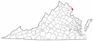
This is a list of the National Register of Historic Places listings in Richmond County, Virginia.

<span class="mw-page-title-main">National Register of Historic Places listings in Scott County, Virginia</span>

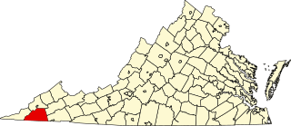
This is a list of the National Register of Historic Places listings in Scott County, Virginia.

References

  1. The latitude and longitude information provided in this table was derived originally from the National Register Information System, which has been found to be fairly accurate for about 99% of listings. Some locations in this table may have been corrected to current GPS standards.
  2. National Park Service, United States Department of the Interior, "National Register of Historic Places: Weekly List Actions", retrieved May 10, 2024.
  3. 1 2 Numbers represent an alphabetical ordering by significant words. Various colorings, defined here, differentiate National Historic Landmarks and historic districts from other NRHP buildings, structures, sites or objects.
  4. "National Register Information System". National Register of Historic Places . National Park Service. April 24, 2008.
  5. The eight-digit number below each date is the number assigned to each location in the National Register Information System database, which can be viewed by clicking the number.
  6. Mathews County Comprehensive Plan, Mathews County, 2001-06-26, 2:15. Accessed 2016-12-13.
  7. Michael Martz (January 23, 2016). "Roof collapses on historic Donk's Theater, known as "Virginia's Lil Ole Opry"". Richmond Times-Dispatch . Richmond, Virginia. Retrieved January 23, 2016.
  8. "Landmark in ruins". Daily Press (Virginia) . January 24, 2016. p. 1. Retrieved September 3, 2022 via Newspapers.com.