
Maryland is a state in the Mid-Atlantic region of the United States. It borders Virginia, West Virginia, and Washington, D.C., to its south and west; Pennsylvania to its north; and Delaware and the Atlantic Ocean to its east. With a total land area of 12,407 square miles (32,130 km2), Maryland is the eighth-smallest state by land area, but its population of 6,177,224 ranks it the 18th-most populous state and the fifth-most densely populated. Baltimore is the largest city in the state, and the capital is Annapolis. The western portion of the state contains numerous stretches of the Appalachian Mountains, while the central portion is primarily composed of the Piedmont. The eastern side of the state makes up the Chesapeake Bay, sharing the border with Delaware, and the southeastern side borders the Atlantic Ocean. Among its occasional nicknames are Old Line State, the Free State, and the Chesapeake Bay State. It is named after Henrietta Maria, the French-born queen of England, Scotland, and Ireland, who was known then in England as Mary.

Montgomery County is the most populous county in the state of Maryland. As of the 2020 census, the county's population was 1,062,061, increasing by 9.3% from 2010. The county seat and largest municipality is Rockville, although the census-designated place of Germantown is the most populous place within the county. Montgomery County, which adjoins Washington, D.C., is part of the Washington–Arlington–Alexandria, DC–VA–MD–WV metropolitan statistical area, which in turn forms part of the Baltimore–Washington combined statistical area. Most of the county's residents live in unincorporated locales, of which the most urban are Silver Spring and Bethesda, although the incorporated cities of Rockville and Gaithersburg are also large population centers, as are many smaller but significant places.

Annapolis is the capital city of the U.S. state of Maryland and the county seat of, and only incorporated city in, Anne Arundel County. Situated on the Chesapeake Bay at the mouth of the Severn River, 25 miles (40 km) south of Baltimore and about 30 miles (50 km) east of Washington, D.C., Annapolis forms part of the Baltimore–Washington metropolitan area. The 2020 census recorded its population as 40,812, an increase of 6.3% since 2010.

Philip Francis Thomas was an American lawyer, mathematician and politician. He served in the Maryland House of Delegates, was the 28th Governor of Maryland from 1848 to 1851, and was Comptroller of Maryland from 1851 to 1853. He was appointed as the 23rd United States Secretary of the Treasury in 1860 in the Buchanan administration. After unsuccessfully standing for the United States Senate in 1878, he returned to the Maryland House of Delegates, and later resumed the practice of law.

The United States District Court for the District of Maryland is the federal district court whose jurisdiction is the state of Maryland. Appeals from the District of Maryland are taken to the United States Court of Appeals for the Fourth Circuit.

These are tables of congressional delegations from Maryland in the United States House of Representatives and the United States Senate.
The 1986 United States House of Representatives elections was held on November 4, 1986, to elect U.S. Representatives to serve in the 100th United States Congress. They occurred in the middle of President Ronald Reagan's second term in office, while he was still relatively popular with the American public. As in most mid-term elections, the President's party — in this case, the Republican Party — lost seats, with the Democratic Party gaining a net of five seats and cementing its majority. These results were not as dramatic as those in the Senate, where the Republicans lost control of the chamber to the Democrats.

The Washington metropolitan area, also sometimes referred to as the National Capital Region or colloquially as the DMV, is the metropolitan area containing Washington, D.C., the federal capital of the United States. The metropolitan area includes all of Washington, D.C. and parts of Maryland, Virginia, and West Virginia. It is part of the larger Washington–Baltimore combined statistical area.

Maryland's 3rd congressional district comprises all of Howard county as well as parts of Anne Arundel and Carroll counties. The seat is currently represented by John Sarbanes, a Democrat.

Maryland's 5th congressional district comprises all of Charles, St. Mary's, and Calvert counties, as well as portions of Prince George's and Anne Arundel counties. The district is currently represented by Democrat Steny Hoyer, who from 2007 to 2011 and from 2019 to 2023 was House Majority Leader.
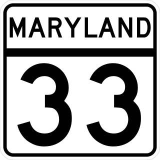
Maryland Route 33 is a state highway in the U.S. state of Maryland. The state highway runs 23.17 mi (37.29 km) from Tilghman Island east to Washington Street in Easton. MD 33 connects Easton, the county seat of Talbot County, with all communities on the peninsula that juts west into the Chesapeake Bay between the Miles River and Eastern Bay on the north and the Tred Avon River and Choptank River on the south. The state highway passes through the historic town of Saint Michaels, home of the Chesapeake Bay Maritime Museum, and enters Tilghman Island by passing over Knapps Narrows on the busiest bascule drawbridge in the United States.

Jeannie Haddaway-Riccio is a politician from Maryland who served as Secretary of the Maryland Department of Natural Resources. She previously served as the deputy chief of staff to Maryland Governor Larry Hogan (2016–2019); as director of intergovernmental affairs for Hogan (2015–2016); and as a member of the Maryland House of Delegates, from District 37B (2003–2015).
The following outline is provided as an overview of and topical guide to the U.S. state of Maryland:

Baltimore is the most populous city in the U.S. state of Maryland. With a population of 585,708 at the 2020 census, it is the 30th-most populous city in the United States. Baltimore was designated an independent city by the Constitution of Maryland in 1851, and today it is the most populous independent city in the nation. As of the 2020 census, the population of the Baltimore metropolitan area was estimated to be 2,838,327, making it the 20th-largest metropolitan area in the country. When combined with the larger Washington, D.C. metropolitan area, the Washington–Baltimore combined statistical area (CSA) has a 2020 U.S. census population of 9,973,383, the third-largest in the country.

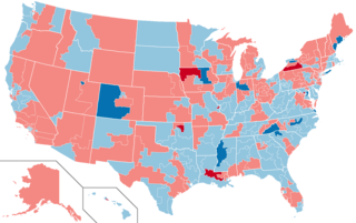
The 2012 United States presidential election in Maryland took place on November 6, 2012, as part of the 2012 United States presidential election in which all 50 states plus the District of Columbia participated. Maryland voters chose 10 electors to represent them in the Electoral College via a popular vote pitting incumbent Democratic President Barack Obama and his running mate, Vice President Joe Biden, against Republican challenger and former Massachusetts Governor Mitt Romney and his running mate, Congressman Paul Ryan.

The following is a list of federal, state, and local elections in the U.S. state of Maryland and can refer to one of the following elections:

