Related Research Articles

Peninsula is a village in Summit County, Ohio, United States. The population was 565 at the 2010 census. It is part of the Akron Metropolitan Statistical Area.

The Cuyahoga River is a river located in Northeast Ohio that bisects the City of Cleveland and feeds into Lake Erie.

Ralph Straus Regula was an American politician from Ohio. A member of the Republican Party, he served in the Ohio House of Representatives, the Ohio State Senate and the United States House of Representatives. He represented Ohio's 16th congressional district for 18 terms from 1973 to 2009. In the 110th Congress (2007–2009), he was the second longest serving Republican member of the House of Representatives.
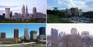
The region Northeast Ohio, in the US state of Ohio, in its most expansive usage contains six metropolitan statistical areas: Cleveland–Elyria, Akron, Canton–Massillon, Youngstown–Warren, Mansfield, and Weirton–Steubenville along with eight micropolitan statistical areas. Most of the region is considered either part of the Cleveland–Akron–Canton, OH Combined Statistical Area and media market or the Youngstown–Warren, OH-PA Combined Statistical Area and media market. In total the region is home to 4,502,460 residents. It is also a part of the Great Lakes megalopolis, containing over 54 million people. Northeast Ohio also includes most of the area known historically as the Connecticut Western Reserve. In 2011, the Intelligent Community Forum ranked Northeast Ohio as a global Smart 21 Communities list. It has the highest concentration of Hungarian Americans in the United States.

Cuyahoga Valley National Park is an American national park that preserves and reclaims the rural landscape along the Cuyahoga River between Akron and Cleveland in Northeast Ohio.

The Ohio and Erie Canal was a canal constructed during the 1820s and early 1830s in Ohio. It connected Akron with the Cuyahoga River near its outlet on Lake Erie in Cleveland, and a few years later, with the Ohio River near Portsmouth. It also had connections to other canal systems in Pennsylvania.
Botzum was a hamlet in Northampton Township, Summit County, Ohio around what is now the intersection of Bath and Riverview Roads in Akron and Cuyahoga Falls.
Tinker's Creek, in Cuyahoga, Summit and Portage counties, is the largest tributary of the Cuyahoga River, providing about a third of its flow into Lake Erie.
Summit Metro Parks is a Metroparks system serving the citizens of Summit County, Ohio by managing 14,000 acres (5,700 ha) in 16 developed parks, six conservation areas and more than 150 miles (240 km) of trails, with 22.4 miles (36.0 km) of the Ohio & Erie Canal Towpath Trail.

This is a list of properties and districts in Ohio that are listed on the National Register of Historic Places. There are over 4.000 in total. Of these, 73 are National Historic Landmarks. There are listings in each of Ohio's 88 counties.

The Pennsylvania and Ohio Canal, also known as the P & O Canal, the Cross Cut Canal and the Mahoning Canal was a shipping canal which operated from 1840 until 1877. It was unique in that it served to connect canals in two states and was funded by private interests.

Cuyahoga Valley Scenic Railroad is a Class III railroad operating diesel-electric and steam-powered excursion trips through Peninsula, Ohio in the Cuyahoga Valley, primarily through the scenic Cuyahoga Valley National Park.

Tinkers Creek Aqueduct is an aqueduct that was constructed to bridge the Ohio and Erie Canal over Tinkers Creek near its confluence with the Cuyahoga River in Valley View, Ohio. It is a relatively rare surviving example of an Ohio and Erie Canal aqueduct. It was originally constructed in 1825-1827 by, and re-built due to flood damage in 1845 and 1905. Tinkers Creek Aqueduct was included in a National Historic Landmark district established in 1966, and it was separately listed on the National Register of Historic Places in 1979. The original Tinkers Creek Aqueduct was a wood plank, steel truss, and Ashlar-sandstone structure constructed in 1827, south of the present aqueduct's location. Cuyahoga River and Tinkers Creek flooding caused continual damage to the original aqueduct, so successive structures were built in 1845 and 1905 in the present location. Today, Tinkers Creek Aqueduct is the only aqueduct which remains of the four original aqueducts in the Cuyahoga Valley. Of Furnace Run Aqueduct, Mill Creek Aqueduct, Peninsula Aqueduct, and Aqueduct; Mill Creek Aqueduct, of newer construction, is the only aqueduct which still carries Ohio and Erie Canal water. After 102 years of flooding, weathering, and deterioration, Tinkers Creek Aqueduct was removed in 2007. The National Park Service is currently working on Phase II of the project to reconstruct it from newer materials.
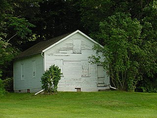
Everett Historic District is a rural village located within Cuyahoga Valley National Park. It is registered on the National Register of Historic Places. Everett is unique for being uncompromised by the pressures of suburban development. It represents a typical unincorporated hamlet of the turn of the 20th century rural America.

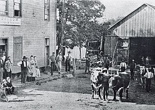
The Boston Mills Historic District is a historic district in the Cuyahoga Valley National Park in Northeast Ohio in the United States. With the opening of the Ohio and Erie Canal in 1827, people began to settle in this vicinity. By 1842, there was a water-powered mill, a large warehouse, a boat-yard, two stores and a hotel, and the population was around 300. A number of houses and other buildings dating back to that period remain.
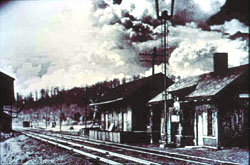
The Valley Railway Historic District is a historic district partially located in the Cuyahoga Valley National Park, extending from Independence to Akron, Ohio. It was added to the National Register of Historic Places in 1985.
The Ohio & Erie Canalway Scenic Byway is a 110-mile (177 km) scenic byway located within the Ohio & Erie Canalway National Heritage Area in Northeast Ohio.

The Ohio and Erie Canal Towpath Trail is a multi-use trail that follows part of the former route of the Ohio & Erie Canal in Northeast Ohio.
The Valley Railway was a shortline railroad which operated between the city of Cleveland and small town of Zoarville in the state of Ohio in the United States. The railroad was founded in 1871, but the first segment of track did not open until 1880 and the line was not completed until 1884. The Baltimore and Ohio Railroad (B&O) obtained a controlling interest in the Valley Railway in 1890. The railroad went bankrupt in 1895, at which time it was reorganized as The Cleveland Terminal and Valley Railroad Company (CT&V). The B&O took over operation of the CT&V in 1909, and the company was merged with the B&O in 1915.
References
- 1 2 "A National Heritage Area". Ohio & Erie Canalway Association. Retrieved 24 April 2012.