Cádiz is a province of southern Spain, in the southwestern part of the autonomous community of Andalusia. It is the southernmost part of mainland Spain, as well as the southernmost part of continental Europe.
Tarifa is a Spanish municipality in the province of Cádiz, Andalusia. Located at the southernmost end of the Iberian Peninsula, it is primarily known as one of the world's most popular destinations for windsports. Tarifa lies on the Costa de la Luz and across the Strait of Gibraltar facing Morocco.
Torrevieja is a seaside city and municipality located on the Costa Blanca in the province of Alicante, in the southern part of the Valencian Community, on the southeastern Mediterranean coast of Spain.
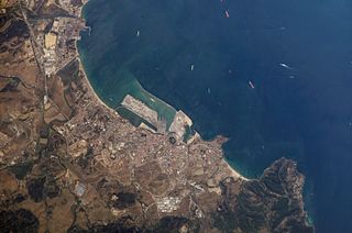
Algeciras is a municipality of Spain belonging to the province of Cádiz, Andalusia. Located in the southern end of the Iberian Peninsula, near the Strait of Gibraltar, it is the largest city on the Bay of Gibraltar.

Chiclana de la Frontera is a town and municipality in southwestern Spain, in the province of Cádiz, Andalucía, near the Gulf of Cádiz. It belongs to the association of municipalities of the Bay of Cádiz, the provincial capital of Cádiz, Jerez de la Frontera, San Fernando, El Puerto de Santa María, Puerto Real and Rota which form the third largest metropolitan area in Andalusia, behind Seville and Málaga, and the twelfth largest in Spain. It is located 20 kilometres south-east from Cádiz, and borders the municipalities of San Fernando and Puerto Real to the north. In 1877, the municipality's population was 11,677; in 2012, it was 81,473. It has a surface area is 203 square kilometres (78 sq mi) and a population density of 401 inhabitants / km2. The average elevation is 11 metres (36 ft) above sea level. The economy depends largely upon modern industry, especially salt processing and tourism, and the municipality is known for its beaches such as the 6 kilometres (3.7 mi) long Playa de la Barrosa, hotels and golf courses in the resort of Novo Sancti Petri. The municipality contains the largest number of hotel beds in the Province of Cádiz and the Costa de la Luz. The town's newspaper, Chiclana Información, is distributed on Saturday mornings.
Playas de Tijuana is the westernmost borough of the municipality of Tijuana, Baja California, stretching from the United States border in the north to Rosarito Beach Municipality in the south. The Bullring by the Sea was opened in 1960.

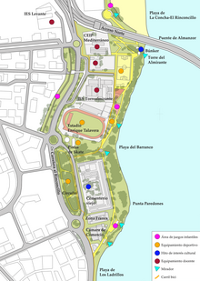
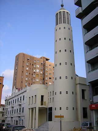
Torre del Almirante is a tower located in Algeciras, Spain. It was declared Bien de Interés Cultural in 1985.

Torre del Arroyo del Lobo is a ruined medieval defensive tower near Algeciras, Spain. It is located in the cove of Getares, and monitored the stretch of coast from Punta Carnero to Punta de San García between the cities of Algeciras and Tarifa as part of the defensive system of the Strait of Gibraltar in the Middle Ages.
The Kursaal of Algeciras is a building in the Paseo del Rio de la Miel of Algeciras, Spain. It is the work of artist Guillermo Pérez Villalta and architect Enrique Salvo. Also known as the Kursaal Congress Centre or Rio de la Miel, it was opened in 2007 after a decade of work. The building was designed in the late nineties as the seat of the Chamber of Commerce of Gibraltar but the work was halted until being rescued by the city council.

The Torre de los Adalides was a rectangular medieval look-out tower of Islamic design located in the vicinity of Algeciras, Spain. It was situated roughly 1 kilometre (0.62 mi) from the coast on a hill some 100 metres (330 ft) above sea level in the area which is now covered by the city's northern suburbs. The tower was demolished by the Spaniards during the Spanish–American War as they thought the Americans might use it as a base of their own. The ruins of the tower are within military limits and cannot be approached without a formal permit.

Playa del Barranco is a beach in the municipality of Algeciras, southeastern Spain. It overlooks the Bay of Algeciras. It is approximately 500 metres in length. To the north is the Playa de El Rinconcillo.

Playa de El Chinarral is a beach in the municipality of Algeciras, southeastern Spain. It overlooks the Bay of Algeciras and the tip of the rock of Gibraltar. It is approximately 250 metres in length and 40 metres wide on average. It is located between Punta de San Garcia and El Rodeo, south of the city.

Municipal Museum of Algeciras is a museum in Algeciras, Spain, located at the northern end of the Parque de las Acacias de Algeciras. It was established in 1995 and is run by the city's cultural department. It houses a large collection of archaeological items which were found in different parts of the city. With its two main divisions, archaeology and history, the museum documents three periods in the city's history: Roman-Byzantine Algeciras, the Andalusian city, and the modern era. A third division, religious art, is located in the Capilla del Cristo de la Alameda.

The Batería de la Atunara was an artillery battery in La Línea de la Concepción, Spain. Constructed by the Spanish military in 1735, it served as part of the line of defenses in the Gibraltar area. It was built by the Government of Spain in fear that the British Overseas Territory would spread over the isthmus.
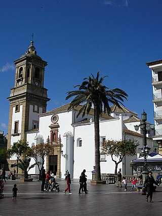
Plaza Alta is a square in the old town of Algeciras, Spain. It is one of the major centres of activity in the city, hosting numerous events and festivals throughout the year. Some of the city's most important buildings such as the Iglesia de la Palma and the Capilla de Europa stand on the square while neighbouring streets include Calle Ancha and Calle Convento.
The siege of Algeciras (1342–1344) was undertaken during the Reconquest of Spain by the Castillian forces of Alfonso XI assisted by the fleets of the Kingdom of Aragon and the Republic of Genoa. The objective was to capture the Muslim city of Al-Jazeera Al-Khadra, called Algeciras by Christians. The city was the capital and the main port of the European territory of the Marinid Empire.

The ruins of Fuerte de San Diego are the remains of a castle located in Algeciras, Spain. The castle was built in 1730 following the Capture of Gibraltar in 1704.