
Cádiz is a city and port in southwestern Spain. It is the capital of the Province of Cádiz, one of eight that make up the autonomous community of Andalusia.
Algeciras is a municipality of Spain belonging to the province of Cádiz, Andalusia. Located in the southern end of the Iberian Peninsula, near the Strait of Gibraltar, it is the largest city on the Bay of Gibraltar. The Port of Algeciras is one of the largest ports in Europe and the world in three categories: container, cargo and transshipment. The urban area straddles the small Río de la Miel, which is the southernmost river of continental Europe. As of 1 January 2020, the municipality had a registered population of 123,078, second in its province after Jerez de la Frontera and greater than Cádiz city population. It forms part of the comarca of Campo de Gibraltar.

Old San Juan is a historic district located at the "northwest triangle" of the islet of San Juan. Its area roughly correlates to the Ballajá, Catedral, Marina, Mercado, San Cristóbal, and San Francisco sub-barrios (sub-districts) of barrio San Juan Antiguo in the municipality of San Juan, Puerto Rico. Old San Juan is the oldest settlement within Puerto Rico and the historic colonial district of the city of San Juan. This historic district is a National Historic Landmark District and is listed on the United States National Register of Historic Places as the Old San Juan Historic District. Several historical buildings and structures, particularly La Fortaleza, the city walls, and El Morro and San Cristóbal castles, have been inscribed in the UNESCO World Heritage Site list since 1983. Historically the mixed use commercial and residential real estate in the main streets like Cristo Street, Fortaleza Street (north) from Tanca Street to the Governor’s Mansion is the most valuable in the area and it has kept its value and increased steadily through several years despite the past economic turmoils.

The University of Cádiz, commonly referred to as UCA, is a public university located in the province of Cádiz, Andalusia, Spain, noted for its medicine and marine sciences curricula. It was founded in 1979, and has the Latin motto Non Plus Ultra. Its headquarters are located in Cádiz, where the Rectorate is. During the 2007/2008 academic year, there were 17,280 students, 1698 lecturers, and 680 administration and services workers associated with the university.

Chiclana de la Frontera is a town and municipality in southwestern Spain, in the province of Cádiz, Andalucía, near the Gulf of Cádiz. It belongs to the association of municipalities of the Bay of Cádiz, the provincial capital of Cádiz, Jerez de la Frontera, San Fernando, El Puerto de Santa María, Puerto Real and Rota which form the third largest metropolitan area in Andalusia, behind Seville and Málaga, and the twelfth largest in Spain. It is located 20 kilometres south-east from Cádiz, and borders the municipalities of San Fernando and Puerto Real to the north. In 1877, the municipality's population was 11,677; in 2012, it was 81,473. It has a surface area is 203 square kilometres (78 sq mi) and a population density of 401 inhabitants / km2. The average elevation is 11 metres (36 ft) above sea level. The economy depends largely upon modern industry, especially salt processing and tourism, and the municipality is known for its beaches such as the 6 kilometres (3.7 mi) long Playa de la Barrosa, hotels and golf courses in the resort of Novo Sancti Petri. The municipality contains the largest number of hotel beds in the Province of Cádiz and the Costa de la Luz. The town's newspaper, Chiclana Información, is distributed on Saturday mornings.

Carúpano is a city in the eastern Venezuelan state of Sucre. It is located on the Venezuelan Caribbean coast at the opening of two valleys, some 120 km east of the capital of Sucre, Cumaná. This city is the shire town of the Bermúdez Municipality and, according to the 2010 Venezuelan census, the municipality has a population of 173,877 inhabitants. Carúpano is considered the gateway to the Paria Peninsula and its main commercial and financial center.

Arcos de la Frontera is a town and municipality in the Sierra de Cádiz comarca, province of Cádiz, in Andalusia, Spain. It is located on the northern, western and southern banks of the Guadalete river, which flows around three sides of the city under towering vertical cliffs, to Jerez and on to the Bay of Cádiz. The town commands a fine vista atop a sandstone ridge, from which the peak of San Cristóbal and the Guadalete Valley can be seen. The town gained its name by being the frontier of Spain's 13th-century battle with the Moors.

Santa Cruz, is the primary tourist neighborhood of Seville, Spain, and the former Jewish quarter of the medieval city. Santa Cruz is bordered by the Jardines de Murillo, the Real Alcázar, Calle Mateos Gago, and Calle Santa María La Blanca/San José. The neighbourhood is the location of many of Seville's oldest churches and is home to the Cathedral of Seville, including the converted minaret of the old Moorish mosque Giralda.

The Chapel of Our Lady of Europe is a Roman Catholic chapel located in the High Square of Algeciras (Spain). The popularly known "Capillita de Europa" is considered as the foundational element of the modern city of Algeciras. It was the host of the statue of the Virgin and the Child kept in the Shrine of Our Lady of Europe from the capture of Gibraltar by the Anglo-Dutch fleet in 1704 to 1864.
Almoraima is a studio album by Paco de Lucía.

The Chapel of the Charity (Spanish: Capilla de la Caridad is a Roman Catholic chapel in Villa Nueva, Algeciras, Spain.
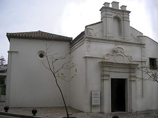
Capilla del Cristo de la Alameda is a chapel in Algeciras, Spain. It was built in 1776 at the initiative of the priest Domingo Perez. The building was then situated along one of Algeciras's main streets of the time, Calle Alameda, and was attended by many sailors entering the port. In 1931 the church was assaulted and in subsequent years was converted into a storehouse and then an auto repair shop until the late 1990s when the city recovered it and it became the headquarters of the Municipal Museum of Sacred Art. The chapel consists of a single room and a small sacristy, and has a Baroque gabled facade.

Municipal Museum of Algeciras is a museum in Algeciras, Spain, located at the northern end of the Parque de las Acacias de Algeciras. It was established in 1995 and is run by the city's cultural department. It houses a large collection of archaeological items which were found in different parts of the city. With its two main divisions, archaeology and history, the museum documents three periods in the city's history: Roman-Byzantine Algeciras, the Andalusian city, and the modern era. A third division, religious art, is located in the Capilla del Cristo de la Alameda.
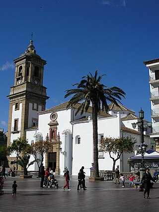
The Church of Our Lady of the Palm is a Roman Catholic church on the southwestern corner of the Plaza Alta in Algeciras, Spain. Listed as Bien de Interes Cultural by the Spanish Ministry of Culture in 1992, like the Spanish: Plaza Alta itself, it is an important city landmark.
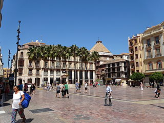
Plaza de la Constitución is a public square in the city center of Málaga, Spain.

Lares barrio-pueblo is a barrio and the administrative center (seat) of Lares, a municipality of Puerto Rico. Its population in 2010 was 2,690.

The Plaza de Isabel II is a historic public square between the Sol and Palacio wards in the central district of Madrid. The plaza is at the convergence of Arenal Street and the minor roads Arrieta, Calle de Campomanes, Caños del Peral, Escalinata and Vergara. It was formed by filling the ravine created by the Arenal stream and the source of the Fountain of the Canals of the Pear Tree. The square occupies part of the site where the old Theater of the Caños del Peral stood between 1738 and 1817.

The history of the Puerta del Sol represents an essential part of the memory of the Villa de Madrid, not only because the Puerta del Sol is a point of frequent passage, but also because it constitutes the "center of gravity" of Madrid's urban planning. The square has been acquiring its character as a place of historical importance from its uncertain beginnings as a wide and impersonal street in the sixteenth century, to the descriptions of the first romantic travelers, the receptions of kings, popular rebellions, demonstrations, etc. It has been the scene of major events in the life of the city, from the struggle against the French invaders in 1808 to the proclamation of the Second Republic in 1931, and it has also retained its place as the protagonist of the custom of serving twelve grapes on New Year's Eve, to the sound of the chimes struck by the Correos clock. Nowadays it is a communications hub, a meeting point, a place of appointments, a place for celebrations and the beginning of demonstrations in the Capital.


