Gibraltar has a limited public transport system, due to the compact size of the territory.

Cádiz is a province of southern Spain, in the southwestern part of the autonomous community of Andalusia. It is the southernmost part of mainland Spain, as well as the southernmost part of continental Europe.

Tarifa is a small town in the province of Cádiz, Andalusia, on the southernmost coast of mainland Spain. It is primarily known as one of the world's most popular destinations for wind sports. The town is located on the Costa de la Luz and across the Strait of Gibraltar facing Morocco.

Punta Cana is a resort town within the Punta Cana-Bávaro-Veron-Macao municipal district, in the municipality of Higüey, in La Altagracia Province, the easternmost province of the Dominican Republic. The area has beaches and balnearios which face both the Caribbean Sea and the Atlantic Ocean, and it is a tourist destination. The weather is hot and humid, especially in late summer and autumn when the Northern Tropics receive their most direct sunlight.

The Strait of Gibraltar crossing is a hypothetical bridge or tunnel spanning the Strait of Gibraltar that would connect Europe and Africa. The governments of Spain and Morocco appointed a joint committee to investigate the feasibility of linking the two continents in 1979, which resulted in the much broader Euromed Transport project.

Castellar de la Frontera is a town and municipality located in the province of Cádiz, in Andalusia, Spain. It is a medieval town within a castle.

The Roman Catholic Diocese of Gibraltar is a diocese of the Latin Rite of the Roman Catholic Church in the British overseas territory of Gibraltar. The Latin name for the diocese is Dioecesis Gibraltariensis. About twenty priests and nine sisters serve in the diocese. Carmelo Zammit was installed as bishop on 24 September 2016.

Punta Colorada is a small peninsula and a resort in the Maldonado Department of Uruguay.

The Action of 19 January 1799 was a minor naval battle of the French Revolutionary Wars fought in waters of the Strait of Gibraltar, off Punta Europa. A Spanish squadron of 14 gunboats with a mistico as flagship, commanded by Francisco Mourelle de la Rua, attacked a British merchant convoy escorted by several Royal Navy warships, among them a 74-gun ship of the line. The British warships failed to defend the convoy, losing a gunboat sunk and another captured. The convoy also lost a ship and two brigs. For this action Mourelle de la Rua was promoted to frigate captain.

Cala Arenas is a beach situated near the city of Algeciras in Spain, within the El Estrecho Natural Park. It is located at the southern end of the Bay of Gibraltar and faces the Strait of Gibraltar. It measures about 400 metres (1,300 ft) long by about 30 metres (98 ft) deep. The beach is somewhat difficult to access, but can be reached via coastal paths from Punta Carnero and Punta del Fraile. It consists of a series of three small coves of similar appearance, with beaches of rocks and small stones. Both the terrestrial and marine environment of the area lies within the natural park. Its surroundings are largely undisturbed by human activity; the nearest settlement is the coastal community of Getares, a small outlying development of the city of Algeciras located about 1 km to the north. The beach is framed by cliffs and the Isla de las Palomas lies a short distance offshore.

Fuerte de Isla Verde was a military installation formerly located in Algeciras, Spain. It occupied the Isla Verde, which gave its name to the city as a whole. The elongated island, which stood a short distance offshore of the city's old town, was already the site of an artillery battery in 1720. In 1734 the fort was constructed on the island to the plans of the military engineer Juan de Subreville. Further remodeling took place in 1745 under Lorenzo de Solís. The installation, which followed the roughly triangular shape of the island, was initially equipped with three batteries. These were:

Punta Carnero Lighthouse is an active lighthouse located on the headland known as Punta Carnero to the south of Algeciras, Spain. The lighthouse was designed and built by Jaime Font, who also designed the lighthouse at Chipiona. Opened in 1874, it overlooks the Strait of Gibraltar.

Torre del Arroyo del Lobo is a ruined medieval defensive tower near Algeciras, Spain. It is located in the cove of Getares, and monitored the stretch of coast from Punta Carnero to Punta de San García between the cities of Algeciras and Tarifa as part of the defensive system of the Strait of Gibraltar in the Middle Ages.

The Torre de los Adalides was a rectangular medieval look-out tower of Islamic design located in the vicinity of Algeciras, Spain. It was situated roughly 1 kilometre (0.62 mi) from the coast on a hill some 100 metres (330 ft) above sea level in the area which is now covered by the city's northern suburbs. The tower was demolished by the Spaniards during the Spanish–American War as they thought the Americans might use it as a base of their own. The ruins of the tower are within military limits and cannot be approached without a formal permit.
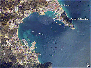
The Río Palmones is a river of the Province of Cádiz in Southeastern coastal Spain. Its source is in Lomas del Castaño, Sierra Blanquilla, and it flows for some 37 kilometres (23 mi) into the Bay of Gibraltar, North of the city of Algeciras, in the neighborhood of Palmones. The Battle of Río Palmones took place here in 1342.
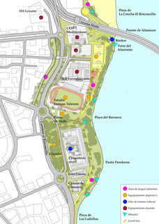
Paseo Cornisa is a park in Algeciras, Spain. It was inaugurated in May 2007. It stretches for just over a kilometre between Punta del Cementerio and Punta del Almirante in the north of the city near the old cemetery and parallel to the Playa del Barranco and Playa de El Rinconcillo. The park has an area of over 20,000 square metres (220,000 sq ft). Within the park is the Torre del Almirante or Admiral's Tower which dates from the 14th century.

Playa de El Chinarral is a beach in the municipality of Algeciras, southeastern Spain. It overlooks the Bay of Algeciras and the tip of the rock of Gibraltar. It is approximately 250 metres in length and 40 metres wide on average. It is located between Punta de San Garcia and El Rodeo, south of the city.

The ruins of Fuerte de San Diego are the remains of a castle located in Algeciras, Spain. The castle was built in 1730 following the Capture of Gibraltar in 1704.