
Shropshire is a landlocked historic county in the West Midlands region of England. It is bordered by Wales to the west and the English counties of Cheshire to the north, Staffordshire to the east, Worcestershire to the southeast, and Herefordshire to the south. A unitary authority of the same name was created in 2009, taking over from the previous county council and five district councils, now governed by Shropshire Council. The borough of Telford and Wrekin has been a separate unitary authority since 1998, but remains part of the ceremonial county.
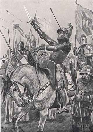
The Battle of Shrewsbury was a battle fought on 21 July 1403, waged between an army led by the Lancastrian King Henry IV and a rebel army led by Henry "Harry Hotspur" Percy from Northumberland. The battle, the first in which English archers fought each other on English soil, reaffirmed the effectiveness of the longbow and ended the Percy challenge to King Henry IV of England.

Shrewsbury and Atcham was a local government district with borough status in Shropshire, England, between 1974 and 2009.
Shropshire was established during the division of Saxon Mercia into shires in the 10th century. It is first mentioned in 1006. After the Norman Conquest it experienced significant development, following the granting of the principal estates of the county to eminent Normans, such as Roger De Montgomery and his son Robert de Bellême.

Bomere Heath is a village in Shropshire, England, which lies north of the county town of Shrewsbury and between Baschurch and Harlescott. It is situated between the A528 road and Berwick Road. The village has a primary school.

Condover is a village and civil parish in Shropshire, England. It is about 5 miles (8 km) south of the county town of Shrewsbury, and just east of the A49. The Cound Brook flows through the village on its way from the Stretton Hills to a confluence with the River Severn. Condover is near to the villages of Dorrington, Bayston Hill and Berrington. The population of the Condover parish was estimated as 1,972 for 2008, of which an estimated 659 live in the village of Condover itself. The actual population measured at the 2011 census had fallen to 1,957.

Albrighton is a large village and civil parish in Shropshire, England, 7.5 miles (12.1 km) northwest of Wolverhampton and 11.3 miles (18.2 km) northeast of Bridgnorth.

Battlefield is a village and suburb of the town of Shrewsbury in Shropshire, England. It is 3 miles (5 km) north of the town centre. The village is today split between three civil parishes - Shrewsbury, Astley and Pimhill.

Shrewsbury and Atcham is a constituency represented in the House of Commons of the UK Parliament since 2005 by Daniel Kawczynski, a Conservative.

Albrighton is a small village in the North Shropshire district of Shropshire, England. It is situated on the A528 Shrewsbury-Ellesmere road and is roughly 4.0 miles (6.4 km) north of Shrewsbury. After a history of being its own parish, it currently lies in the parish of Pimhill. According to the United Kingdom Census 2001, the parish population of Pimhill was 2008, with the number of these habiting in Albrighton being 273.

Shropshire Council is the local authority of Shropshire, in England, comprising the ceremonial county of Shropshire except Telford and Wrekin. It is a unitary authority, having the powers of a non-metropolitan county and district council combined.

Old Woods is a hamlet in Shropshire, England, located 4 miles (6.4 km) to the north-west of Shrewsbury. It is alternatively known and spelt as Oldwood, Oldwoods and Old Wood.

Preston Gubbalds is a small village in Shropshire, England. It lies on the A528 Shrewsbury-Ellesmere road and is in the parish of Pimhill.
Shrewsbury is a market town, civil parish, and the county town of Shropshire, England, on the River Severn, 150 miles (240 km) north-west of London. At the 2021 census, it had a population of 76,782.

St Martin's Church is a redundant Anglican church in the village of Preston Gubbals, Shropshire, England. It is recorded in the National Heritage List for England as a designated Grade II* listed building, and is under the care of the Churches Conservation Trust.

Battlefield Heritage Park is a country park situated north of Shrewsbury in Shropshire, in the area known as Battlefield. It marks the supposed site of the 1403 Battle of Shrewsbury fought between King Henry IV and English rebel nobleman Henry Percy.
Pimhill is a civil parish in Shropshire, England. It contains 67 listed buildings that are recorded in the National Heritage List for England. Of these, twelve are at Grade II*, the middle of the three grades, and the others are at Grade II, the lowest grade. The parish is to the northwest of Shrewsbury, it contains the villages of Albrighton, Atcham, Fitz, Leaton, Merrington and Preston Gubbals and smaller settlements, and is otherwise rural. In the parish are a former manor house and seven country houses that are listed, together with structures associated with them. Otherwise, most of the listed buildings are smaller houses, cottages, farmhouses and farm buildings, the older of which are timber framed, or have timber-framed cores. The other listed buildings include churches and items in the churchyards, a private chapel, a group of almshouses, an eyecatcher, a war memorial, and five mileposts,
